An Investigation into the 2012 drought on Apalachicola River. Steve Leitman, Bill Pine and Greg Kiker
|
|
|
- Lester Berry
- 5 years ago
- Views:
Transcription
1 An Investigation into the 2012 drought on Apalachicola River Steve Leitman, Bill Pine and Greg Kiker
2
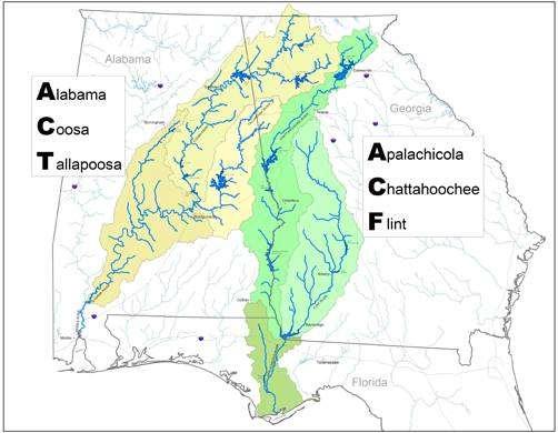
3 Apalachicola-Chattahoochee-Flint (ACF) River basin 20,400 sq. mi. One of the most actively disputed river basins in the U.S. Lies in Alabama (12.5%), Florida (12.5%), and Georgia (75%) No agreement on the allocation of water resources Average annual precipitation in the basin 55 Evapotranspiration about annually Average annual runoff 15-40
4 Apalachicola-Chattahoochee-Flint River basin Chattahoochee 13 dams, multi-purpose operations. Three large storage reservoirs operated by Corps, other dams have limited to no storage capacity. Lake Lanier largest reservoir and provides municipal water supply for Atlanta region. Flint 2 dams, no storage capacity Lake Blackshear largest Very large ag interests, surface and groundwater water withdrawals.
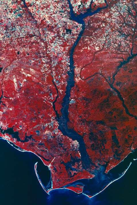
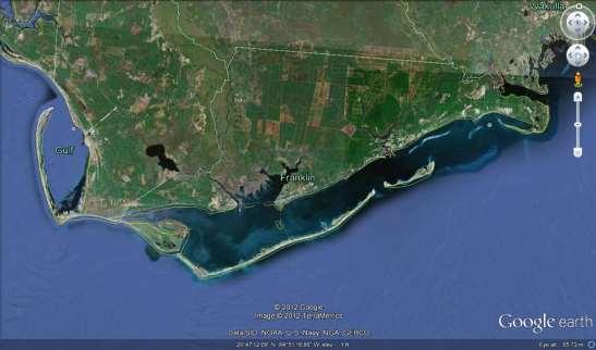
5 THE APALACHICOLA RIVER
6 . Apalachicola River River begins at the confluence of Chattahoochee and Flint Rivers. Most biologically diverse river ecosystem in the east. Flow in river defined by rainfall and water management in Georgia and Alabama, not local conditions. Jim Woodruff Dam Navigation, recreation Minimal storage capacity Head limit problems effect operation No fish passage Minimum flow 5000 CFS Influenced by upstream storage Apalachicola River 106 miles from dam to Apalachicola estuary 40 ft elevation change Large floodplain Average daily stream flow about 20,000 cfs at Jim Woodruff inflow and 23,600 cfs at Sumatra gage ( ) 5000-~200,000 CFS River width few hundred feet to 4.5 miles

7 Bluff at Estiffanulga (NM 63)
 Perception that reservoir operations have large impacts on")
8 Big river, small reservoirs About 1.2 million ac-ft active reservoir storage ~66% of storage in Lake Lanier (headwaters) Perception that reservoir operations have large impacts on downstream flows Reductions in downstream flows impacting coastal resources? Atlanta is stealing all of our water
9 ELEVATION IN FEET BUFORD DAM (Lake Sidney Lanier) PROFILE APALACHICOLA AND CHATTAHOOCHEE RIVERS Atlanta, GA WEST POINT LAKE Head of Navigation CHATTAHOOCHEE RIVER Columbus, GA WALTER F. GEORGE L&D 200 GEORGE W. ANDREWS L&D JIM WOODRUFF L&D 0 APALACHICOLA RIVER MILES
10 drought
11


12
13
14 Simple question. In 2012, could ACF reservoirs have been operated in a manner to restore Apalachicola River flows to levels that would have protected the Apalachicola estuary?
15 Simple question. In 2012, could ACF reservoirs have been operated in a manner to restore Apalachicola River flows to levels that would have protected the Apalachicola estuary? If YES Then reservoirs could be used to augment flows to Apalachicola River and Bay during extreme drought conditions. A simple intuitive solution to the complex issue related to freshwater inflows to Apalachicola Bay.
16 Simple question. In 2012, could ACF reservoirs have been operated in a manner to restore Apalachicola River flows to levels that would have protected the Apalachicola estuary? If YES Then reservoirs could be used to augment flows to Apalachicola River and Bay during extreme drought conditions. A simple intuitive solution to the complex issue related to freshwater flows to Apalachicola Bay. If NO By eliminating the simple, intuitive solution more holistic options need to be conceived.
17 2012 conditions in the ACF basin...
 River flow lowest on period of record (1922")
18 Drought Conditions 2012 Rainfall deficits 8-18 inches in the basin (15% 33% below average) Record low ground water levels Driest region in the country ( ) River flow lowest on period of record ( )
19 2012 conditions in Apalachicola... Record low river flows in 2012 (and several of preceding years)

20 2012 conditions in Apalachicola... Record low river flows in 2012 (and several of preceding years)
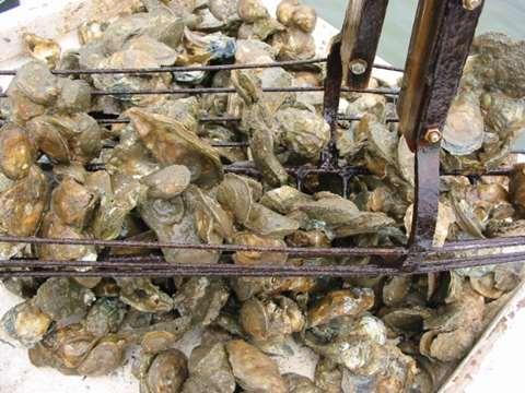
21 2012 conditions in Apalachicola Bay... High salinities and high temperatures
22 Simple question. Could reservoir releases increase Apalachicola River discharge, lower salinity in Apalachicola Bay, ultimately benefiting oyster populations?
23 Simple question. Could reservoir releases increase Apalachicola River discharge, lower salinity in Apalachicola Bay, ultimately benefiting oyster populations? We are not sure about the last part, but we can answer the first part
24 Methods Results are based on a simple accounting of flow deficits and storage available in the basin. At the beginning of 2012, reservoir storage in the ACF basin was not at full capacity and Corps was operating the reservoirs under emergency drought provision measures. By the current reservoir operating plan, emergency drought provision measures are not lifted until the reservoirs are nearly refilled.
25 All Values in Feet Above Mean Sea Level Lanier Elevations: TOP OF POOL TOP OF ZONE 2 TOP OF ZONE TOP OF ZONE elevations 2012 elevations Initial Impact Level Recreation Impact Level Water Access Limited Level Bottom of Conservation Pool Jan Jan Mar Apr May May Jun Jul Aug Sep Oct Nov Dec
26 All Values in Feet Above Mean Sea Level West Point Elevations: elevations 2012 elevations Initial Impact Level Recreation Impact Level Water Access Impact Level Bottom of Conservation Pool /1 1/31 3/1 3/31 4/30 5/30 6/29 7/29 8/28 9/27 10/27 11/26 12/26
27 Jan Jan Jan Feb Feb Mar Mar Apr Apr May May Jun Jun Jul Jul Jul Aug Aug Sep Sep Oct Oct Nov Nov Dec Dec Dec All Values in Feet Above Mean Sea Level W.F. George elevations: elevations 2012 elevations Initial Impact Level Recreation Impact Level Water Access Limited Level Bottom of Conservation Pool
28 Methods The average inflow from the Flint River to Lake Seminole for 2012 was 2,583 cfs, by far the lowest average ever in the period of record. When this average value is compared to the next lowest value in the period of record (2011), it is more than 1,000 cfs less than that year. To put the volume of this deficit in context, nearly half of the total storage capacity of the entire ACF reservoir system would have to be released to make inflow to Lake Seminole from the Flint basin for the 2011 and 2012 comparable.
29 Methods To further put this deficit into context, the total average annual consumptive withdrawals from the Flint and Chattahoochee Rivers above Jim Woodruff Dam was about 1,250 cfs in The net average annual municipal and industrial demands were about 750 cfs and the average annual agricultural irrigation demand effect on stream flow was about 500 cfs. The average annual withdrawal from the Chattahoochee basin was about 650 cfs and from the Flint basin about 600 cfs.
30 Flow (cfs) Bainbridge flow ( ) MEDIAN 75% EXCEEDED 90% EXCEEDED 95% EXCEEDED Jan Jan Feb Mar Mar Apr May May Jun Jul Jul Aug Sep Oct Oct Nov Dec Dec
31 Methods Average outflow from JW Dam in 2012 = 7,600 cfs. In the 90 year period of record for at Chattahoochee, Florida, average annual flows at this location were below 10,000 cfs in only three other years (2000, 2007 and 2011). The next lowest flow was > 9,300 cfs. The 1000 cfs + deficit from the Flint was only part of the problem, flows were also depressed on the Chattahoochee side of the basin.
32 Flow (cfs) Jim Woodruff outflow ( ) Jan Jan Feb Mar Mar Apr May May Jun Jul Jul Aug Sep Oct Oct Nov Dec Dec
33 Methods The amount of additional augmentation from the ACF reservoir system to make 2012 releases comparable to the next lowest year in the 90 year period of record would require releasing more than ¾ of the total storage capacity of the reservoir system. And, this would be required in a year where there was very limited refilling of the reservoirs, the volume of water in storage was already depressed from full storage and at a time the length of the drought was not known.
34 Flow (cfs) Sumatra flow ( ) MEDIAN 75% EXCEEDED 90% EXCEEDED 95% EXCEEDED Jan Jan Feb Mar Mar Apr May May Jun Jul Jul Aug Sep Oct Oct Nov Dec Dec
35 In summation, it is apparent that it would not have been possible to manage the federal storage reservoirs in a different manner to have increased Apalachicola River flows to median levels during 2012.
36 The fundamental issue in the ACF basin remains small storage capacity relative to large river discharge. Small storage capacity limits the ability to manage our ways out of climate related droughts. It does not seem that all of our problems can be solved by simply being better managers managing our way out of frequent drought will at best be extremely challenging.
37 Another interesting question relating to the 2012 drought is whether this event is an anomaly and the flow data in the period of record ( ) is what can be expected in the future? Or,is flow data in the period of record the anomaly and the drought a portent of what should be expected in the future?
38 Recent research into long-term climate data suggests that over the past 500 years there have been multiple droughts which are both longer and more severe and that the past years have had the least number of severe drought than any period in the last 500 years. This information further stresses the need to re-think our approaches to management problems in the ACF basin.
39 end