STATE COLLEGE BOROUGH WATER AUTHORITY LAND DEVELOPMENT LEGAL AUTHORITY. Robert Mix, Esq. Authority Solicitor Lee, Green & Reiter, Inc.
|
|
|
- Phoebe Moore
- 5 years ago
- Views:
Transcription
1 STATE COLLEGE BOROUGH WATER AUTHORITY LAND DEVELOPMENT LEGAL AUTHORITY Robert Mix, Esq. Authority Solicitor Lee, Green & Reiter, Inc.
2 STATE COLLEGE BOROUGH WATER AUTHORITY SYSTEM OVERVIEW Brian Heiser Assistant Executive Director State College Borough Water Authority
3 QUICK FACTS Susquehanna River Basin Commission Withdrawal Limit: 9.1MGD Average Daily Demand: 5.0 MGD Current Peak Day Demand: 6.2 MGD Current Minimum Day Demand: 3.6 MGD Customers: 14,700 Estimated Population Served: 75,000 Service Area: State College Boro & Benner, College, Ferguson, Harris, Patton Twps
4 SOURCES OF SUPPLY Slab Cabin Run: 7.3 MGD (All Sources Filtered) Shingletown Gap Reservoir MGD, Peak Harter Well Field MGD, Peak Thomas Well Field MGD, Peak Nixon Well Field: 3.00 MGD Kocher Well Field: Not to Exceed 25% of Total Demand Chestnut Ridge Well Field: 1.01 MGD Alexander Well Field: 4.70 MGD Grays Woods Well Field: 3.88 MGD

5 WATER SUPPLY, PUMPING AND TREATMENT FACILITIES MAP

")


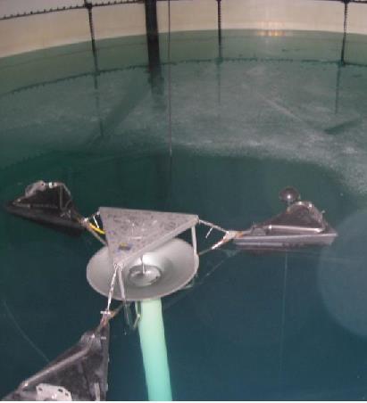
6 WATER SUPPLY AND TREATMENT FACILITIES 7 Well Fields (23 Wells) Woodside Water Treatment Plant (6 MGD) Shingletown Reservoir 6 Pump Stations


7 DISTRIBUTION, STORAGE & CUSTOMER FACILITIES 240 Miles of Pipe & 1,100 Fire Hydrants 14,700 Meters (Advanced Metering Infrastructure) Tank Mixing Systems 13 Storage Tanks (15.75 MG)

8 WOODSIDE WATER TREATMENT FACILITY SOURCES Raw Water Sources: Shingletown Gap Reservoir Seasonal Harter Well Field 3 Wells, GUDI Thomas Well Field 4 Wells, GUDI Potential Sources of Contamination: Agricultural Activities Highway Runoff On-Lot Septic Systems Sinkholes


9 WOODSIDE WATER TREATMENT PROCESS Treatment: Multi-Media Filters for Particle & Bacterial Removal Chemical Addition to Enhance Particle Removal Chlorine Disinfection Production: 3.0 MGD (60% of total production) Age: Approaching 20 Years of Service Condition: Upgrade Required in 5 to 10 Years
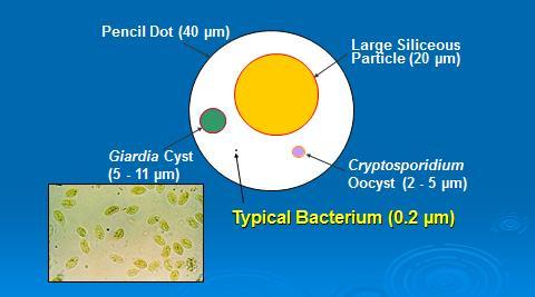
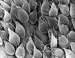
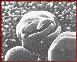
10 FILTRATION SYSTEM REMOVAL - RELATIVE PARTICLE SIZE
11 PROTECTING GROUNDWATER IN THE SPRING CREEK WATERSHED David Yoxtheimer, PG AquaLith Technologies, LLC SCBWA Hydrogeological Consultant
, MOST OF IT IS RETURNED VIA WASTEWATER")
12 SPRING CREEK BASIN HYDROLOGIC CHARACTERISTICS THE BASIN DRAINS 175 SQ. MI. INCLUDING 29 SQ. MI. WITHIN SPRUCE CREEK VIA GROUNDWATER DIVERSION AVERAGE GROUNDWATER RECHARGE RATE OF ABOUT 734,000 GALLONS PER DAY PER SQ. MI. AVERAGE BASEFLOW OF ~125 MILLION GALLONS/DAY AT MILESBURG PUBLIC WATER SUPPLIES WITHDRAW ~7-8% OF TOTAL GROUNDWATER RECHARGE FROM THE BASIN (9-10 MGD), MOST OF IT IS RETURNED VIA WASTEWATER TREATMENT PLANTS (Source: USGS, 2005)

13 GROUNDWATER IN THE SPRING CREEK BASIN GROUNDWATER IS THE PRIMARY SOURCE OF DRINKING WATER IN THE SPRING CREEK BASIN (>95%) BASE FLOW IN SPRING CREEK SUSTAINS 86% OF ITS FLOW THE FRACTURED, KARSTIFIED CARBONATE BEDROCK AQUIFERS THAT UNDERLIE THE VALLEY FLOOR PROVIDE PROLIFIC WATER SUPPLIES.YET ARE VULNERABLE TO DEGRADATION MOUNTAIN RIDGES AND SLOPES REPRESENT ABOUT 22% OF THE BASIN S AREA WHILE MOUNTAIN RUNOFF REPRESENTS AT LEAST 33% OF SPRING CREEK S FLOW


14 GEOLOGIC MAPPING OF SPRING CREEK WATERSHED Basin s geology consists of complex folded and faulted carbonate bedrock valleys with sandstone ridges and shale slopes (Source: USGS, 2005)

15 WATER TABLE MAP OF SPRING CREEK BASIN (Source: USGS, 2005)

16 GROUNDWATER RECHARGE MECHANISMS IN SPRING CREEK (Source: USGS, 2005)
17 WELLHEAD PROTECTION AREA DELINEATION PADEP defines three (3) Wellhead Protection Areas: Zone 1: radius around each well which is dependent on pumping rate and aquifer characteristics. No activity can occur within this area and must be controlled by the public water supplier. Zone 2: Capture zone within the aquifer of each well/wellfield that can be estimated through groundwater flow modeling or through hydrogeologic mapping/interpretation Zone 3: Surface area that drains into the capture zone which is determined topographically It is important to identify potential sources of contamination within source water protection areas and prevent impacts through Best Management Practices and zoning restrictions

18 ZONE 2 SCBWA WELLHEAD PROTECTION AREAS Alexander WF Airport Grays Woods WF Nixon-Kocher WF Thomas-Harter WF Halfmoon Valley The Cottages Ramblewood Pine Grove Mills Ag Prog Days PA Furnace
19 POTENTIAL CONTAMINATION SOURCES TRANSPORTATION CORRIDORS: SPILLS, DEICING CHEMICALS AGRICULTURE ACTIVITIES: FERTILIZERS, HERBICIDES, PESTICIDES, ANIMAL WASTE SANITARY SEWERS: LINE BREAKS DISCHARGING UNTREATED SEWAGE ON-LOT SEWAGE DISPOSAL SYSTEMS: FAILING SEPTIC TANKS AND DRAIN FIELD SYSTEMS COMMERCIAL/RESIDENTIAL DEVELOPMENT: STORMWATER RUNOFF SINKHOLE DEVELOPMENT: DIRECT PATHWAYS TO AQUIFERS DUMPS: ILLEGAL DUMPS WITH MISCELLANEOUS CONTAMINANTS DRINKING WATER PLANTS: CHLORINE GARAGES/GAS STATIONS: UG STORAGE TANK PETROLEUM PRODUCT LEAKAGE RCRA FACILITIES: RELEASE OF INDUSTRIAL COMPOUNDS

20 KARST SYSTEM RECHARGE MECHANISM THE NATURE OF THE GROUNDWATER FLOW SYSTEM AND ITS MORE DIRECT CONNECTION TO THE SURFACE CAUSES KARST AREAS TO BE VULNERABLE TO GROUNDWATER CONTAMINATION FROM SURFACE SOURCES


21 ZONE 2 & 3 WELLHEAD PROTECTION AREAS FOR THOMAS HARTER WELLS - POTENTIAL CONTAMINATION SOURCES The Cottages Thomas-Harter WF Ag Prog Days Pine Grove Mills


22 STORMWATER, SOILS & SINKHOLES Red: Closed depression Green: Sinkhole THE COMBINATION OF KARST TERRAIN AND LAND USE CHANGES IN THE WRONG PLACES ON THE WRONG SOILS WITHOUT ADEQUATE STORMWATER MANAGEMENT PRACTICES CAN HAVE ADVERSE IMPACTS ON THE REGION S WATER QUALITY.
23 LESSONS LEARNED FROM THE SCBWA SWP PROGRAM NON-POINT SOURCES OF CONTAMINATION (ROADS, SURFACE RUNOFF, AGRICULTURAL) ARE MORE OF A THREAT THAN POINT SOURCES CONTAMINANTS HAVE POTENTIAL TO MOVE THROUGH THE KARST AQUIFER RAPIDLY (100 s s of FEET PER DAY) REGIONAL WATER SUPPLY WELL FIELDS HAVE RELATIVELY LARGE RECHARGE AREAS WITH VARYING LAND USES WITHIN LONG-TERM MANAGEMENT OF VARYING LAND USES IN MULTIPLE MUNICIPALITIES CAN BE CHALLENGING, NEED REGIONAL COOPERATION THERE ARE EXAMPLES OF HISTORIC AND RECENT SURFACE ACTIVITIES THAT SHOW SIGNS OF IMPACTING WATER QUALITY: SMALL CHANGES IN LAND USE ADD UP TO MEASURABLE CUMULATIVE IMPACTS CONSIDER SOIL AND BEDROCK CONDITIONS TO GUIDE LAND USE OVERALL, THE REGION S WATER SOURCES ARE HIGH QUALITY BUT WE NEED TO WORK HARD TO KEEP IT THAT WAY!
24 THE COTTAGES STORMWATER MANAGEMENT PLAN TECHNICAL REVIEW PROCESS Mark Glenn, P.E., President Gwin, Dobson & Foreman, Inc. SCBWA Engineering Consultant
25 TECHNICAL REVIEW PROCESS SCBWA was invited to participate in the technical review of the plans for the Toll Brothers The Cottages Planned Residential Development. SCBWA input was provided in advisory capacity to the Township which is responsible for implementing and enforcing its zoning, land planning and site development ordinances. Review was undertaken by SCBWA Source Water Protection Committee, SCBWA Staff, Authority Hydrogeologist and Authority Consulting Engineer
26 TECHNICAL REVIEW TEAM Technical Review Team Team oversight by SCBWA Source Water Protection Committee Legal review and guidance by Robert Mix, Authority Solicitor Aquifer and geological impacts assessed by David Yoxtheimer, PG, Authority Hydrogeologist Site stormwater management system reviewed by Gwin, Dobson & Foreman, Authority Engineer Water system operational impacts assessed by SCBWA staff Site soils and stormwater detention input from Source Water Protection Committee team members
27 GUIDANCE DOCUMENTS Reports, Manuals, Reference Standards & Ordinances 2007 SCWBA Source Water Protection Plan SCBWA Well Head Protection (WHP) Area Delineations PADEP Stormwater Management Best Management Practices Manual Ferguson Township Ordinance No. 990 Ferguson Township Chapter 26 Stormwater Management Ordinance
28 TECHNICAL REVIEW TIMELINE Technical review comments were provided at the following plan review milestones: March 24, 2014: October 9, 2014: January 7, 2015: April 21, 2015: June 26, 2015: Planning Level Review Preliminary PRD Plan Review Preliminary PRD Plan Resubmission Review Final PRD Initial Plan Submission Final PRD Final Plan Submission
29 TECHNICAL REVIEW COMMENTS Preliminary Determinations: The Cottages is located in the Zone 2 Well Head Protection (WHP) area of Thomas-Harter well field aquifer Note: SCBWA Zone 2 WHP area does not precisely correspond to Twp. sensitive area boundary (Nittany Geoscience, 1992, Exh. 1, Appendix B) Tributary of Slab Cabin Run bisects site (recharge mechanism for aquifer) Field investigations show rock outcrops and shallow bedrock; property bounded by sinkholes and fracture traces Water quality concerns: deicing agents, nitrates, oil/gas spills, soil migration, lawn chemicals Based on location in Zone 2 WHP area, Chapter 7.6 of DEP Stormwater Management BMP Manual for Well Head Protection areas was consulted
30 TECHNICAL REVIEW COMMENTS SCBWA Technical Review Highlights Best Management Practices (BMPs): Activities or structural improvements that help reduce the quantity and improve the quality of stormwater runoff. BMPs include treatment requirements, operating procedures and practices to control site runoff Stormwater Management (SWM) Design: Use Pretreatment BMP s with amended soil layers for filtering pollutants Non-Structural BMP s Maximize use of vegetated channels and buffers Existing Soils: Retain soil profile for natural stormwater filtering, where practicable Rock Excavation: Minimize excavation to prevent rock shattering and fracturing Drilling & Blasting: If required, prepare pre-blast plan & geological report Construction Practices: Prohibit compaction of swales, channels and basin bottoms
31 TECHNICAL REVIEW COMMENTS SCBWA Technical Review Highlights Geophysical Surveys: Perform electrical resistivity testing to identify existing sinkholes and rock fractures as accelerated pathways to aquifer system Stormwater Detention: Decentralize SW detention throughout site, reconfigure detention basins sited in rock, retain soil as a base for amended soil layers Sinkhole Development: Repair details, contingency plans, notification protocols Construction and Post-Construction Inspections: SCBWA access Monitoring Well: Water Quality Monitoring installed down-gradient of site (Refer to Detailed Technical Review at under News/Meetings)

32 RECOMMENDED DECENTRALIZED SWM AND BMP PLAN
33 TOWNSHIP LAND DEVELOPMENT RECOMMENDATIONS Jason Grottini, Chairman Source Water Protection Committee State College Borough Water Authority
34 POLICY RECOMMENDATIONS Development of a new Well Head Protection Area Overlay District which corresponds to the delineated SCBWA Well Head Protection Zones (1, 2 & 3) In conjunction with the above, develop Regulated Land Uses and Activities permitted in the WHPA Overlay District As a Interested Stakeholder, Solicit Input and Participation of SCBWA in the Township Planning and Review Process
35 STANDARDS & PRACTICES RECOMMENDATIONS Develop Specific Land Development Standards and Practices for Site Developments in WHPA Overlay Districts: Geological Reports & Investigations that Demonstrate Compliance Identify closed depressions, sinkholes, outcrops, lineaments, faults & fracture traces, surface drainage into ground Geophysical Testing of Subsurface Conditions (sinkholes, fractures, etc) Decentralization of SWM Detention Facilities Maximize Use of Non-Structural BMP s Minimize Rock Disturbance and Limit Disturbance of Native Soils Reference PADEP BMP Guidance Manual for SWM Design Criteria
36 STANDARDS & PRACTICES RECOMMENDATIONS Develop Specific Land Development Standards and Practices for Site Developments in WHPA Overlay Districts: Provisions for SCBWA Construction Inspection Access Develop Specifications for SWM Construction Practices & Performance Post Construction Monitoring and Inspection Township Engineer to Review SWM/BMP Plans in a Fashion Similar to SCBWA Review of The Cottages Plans Provisions for Developer to reimburse SCBWA-incurred costs