City of Barrie Ross/Collier/Bayfield Streets Study Design DRAFT
|
|
|
- Jessica Melton
- 5 years ago
- Views:
Transcription


1 City of Barrie Ross/Collier/Bayfield Streets Study Design DRAFT November 7, 2016 BT Eng Project Number
2 Table of Contents 1.0 Study Introduction Preface Study Area Background Need and Justification Study Approach Guiding Principles Environmental Assessment Act Requirements EA Phases Study Process Public Consultation Approach Work Program Study Schedule Assessment of Planning Solutions Alternative Planning Solutions Preliminary Design Alternatives Preferred Design Criteria Preliminary Design Considerations List of References 35 Appendix A: Glossary of Terms 36 List of Figures Figure 1: Study Area 2 Figure 2: City of Barrie Waterfront/Downtown Transportation Improvements Class EA (2004) 4 Figure 3: Municipal Class EA Process 8 Figure 4: Generalized Study Process 9 Figure 5: Long List of Ross/Collier/Bayfield Intersection Alternatives 21 Figure 6: Carried Forward Intersection Alternatives A, B and C 22 Figure 7: Carried Forward Intersection Alternatives D, E and F 23 Figure 8: Carried Forward Intersection Alternatives G and H 24 Figure 9: Range of Roundabout Inscribed Circle Diameters under Design Consideration 25 i
3 Figure 10: Ross Street Preliminary Alternative Concepts 27 Figure 11: Collier Street Preliminary Alternative Concepts 28 Figure 12: Bayfield Street Preliminary Alternative Concepts 29 Figure 13: TAC Sidewalk Requirements 30 List of Photos Photo 1: Adjacent Intersections 34 Photo 2: Existing Ross/Collier/Bayfield Street Intersections 34 List of Tables Table 1: Design Criteria for Bayfield Street 31 Table 2: Design Criteria for Collier Street 31 Table 3: Design Criteria for Ross Street 32 ii
4 1.0 Study Introduction 1.1 Preface The City of Barrie has initiated this Municipal Class Environmental Assessment (EA) to review and validate Phases 1 and 2 and then to undertake the completion of Phases 3 and 4 of the Municipal Class EA Process for the proposed widening and realignment of Ross Street from Toronto Street to Bayfield Street to three lanes with buffered bicycle lanes and sidewalks on both sides. Intersection improvements will be considered for the intersection of Ross Street, Collier Street and Bayfield Street including signalization, roundabout or traffic operations improvement in the downtown traffic analysis study area. Improvements would extend to Collier Street and Clapperton Street. The project will obtain environmental clearance and seek stakeholder consensus for the improvements that will include definition of the municipal servicing to properties, roadway entrance locations, property requirements, stormwater management, sidewalks and bike lanes to support multiple modes of travel (pedestrian, bicycling, transit, vehicular traffic and truck traffic). The roadway plan will establish the servicing for the land use plan to accommodate potential residential and commercial redevelopment for the next years. It will need to have flexibility to accommodate future modifications to the lot fabric and land uses. This report is the initial public document for the Ross/Collier/Bayfield Streets EA Study. It presents a blueprint of the Work Plan and Study Process for the planning and design of this future transportation project. 1.2 Study Area The project location is within the City of Barrie. The Study will define the entire right-of-way protection plan to accommodate: Proposed horizontal alignment; Vertical alignment; Intersection modifications; Intersection treatments; Cross section elements (sidewalks, boulevards, bicycle lanes or shared lanes); Utilities and municipal services; Lighting; Driveway entrance locations; and Any required widening to accommodate grading. The Study Area, illustrated in Figure 1, consists of Ross Street from Toronto Street to Bayfield Street (including both intersections); Bayfield Street from Ross Street to Collier Street (including both intersections); and, Collier Street from Bayfield Street to Clapperton Street (including both intersections). The traffic analysis will involve a wider study area, as shown in Figure 1. 1

5 Figure 1: Study Area 2
6 1.3 Background Ross/Collier/Bayfield is an east-west twolane collector road with an urban cross section providing access to residential and commercial properties in downtown Barrie. Due to increased traffic volumes in the downtown core, the proximity of signalized intersections, the volume of pedestrians and recommendations from the MMATMP, there is a need to optimize the road network. Existing infrastructure limits the opportunity for road widening through downtown, therefore the offset T-intersections at Ross/Collier/Bayfield are recognized to be a critical location for improving traffic operations through the downtown core. The current offset intersections restrict the movement of through traffic for Collier and Ross Streets and the conflicting left turn movements on Bayfield Street can result in gridlock. Intersection improvements will consider: realignment of Ross Street to Collier Street; construction of a roundabout at Ross/Bayfield Streets; or signalization of the intersection. With realignment of Ross and/or Collier Streets the installation of traffic signals in such close proximity would create a challenge for signal coordination and issues related to traffic queuing through the adjacent signals. Roadway widening is limited by the adjacent development; however, opportunities for auxiliary lanes and accommodating all active modes of transportation will be major considerations along with other municipal infrastructure improvements. The City of Barrie Waterfront/Downtown Transportation Improvements Class Environmental Assessment dated December 2004, examined the need for improvements in the area of Lakeshore Drive, Bradford Street, Simcoe Street and Toronto Street. The Phase 3 and Phase 4 Class EA reviewed a subset of the previous Phase 1 and Phase 2 Class EA Waterfront/Downtown Transportation Improvements Needs Assessment dated November 2002, which had included the intersections of Ross Street and Collier Street at Bayfield Street within the study area. A City of Barrie staff report, dated September 8, 2003, appended in the 2004 Class EA, indicated that the intersections of Ross Street and Collier Street at Bayfield Street operated inefficiently and that the 1999 Transportation Study by Read, Voorhees Ltd recommended realignment of the Ross/Bayfield/Collier intersection. Realignments considered, and presented to the public, as part of the 2002 Class EA, were: Collier Street to the north, Ross Street to the south and a combination of both. The recommended alignment, as shown in Figure 1, realigned Ross Street to the south. This option was generally consistent with the 1999 Transportation Study and was generally supported by the public, while not impacting the historically significant building on the northeast corner of the intersection of Collier and Bayfield Streets (or the Barrie Community Health Centre or Youth Centre occupying part of the building). The final EA report was not advertised for a 30 day review period. The City chose to adopt the preferred alternative for planning purposes only because implementation was anticipated to occur beyond the 10 year window allowed under the Environmental Assessment Act. 3
")
7 Figure 2: City of Barrie Waterfront/Downtown Transportation Improvements Class EA (2004) 4
8 1.4 Need and Justification The Multi-Modal Active Transportation Master Plan (MMATMP) addressed Phases 1 and 2 of the five-phase Municipal Class EA Process for Citywide transportation improvements. Ross Street is an existing 2-lane major collector with an urban cross-section and sidewalks on both sides. The MMATMP recommends widening this road to 3 lanes with the addition of a continuous two way left turn lane, buffered bicycle lanes and sidewalks on both sides. This project will include an assessment of intersection alternatives at the intersection of Ross Street, Collier Street and Bayfield Street including signalization, roundabout or traffic operations improvements in the downtown traffic analysis study area. Transportation improvements would extend to Collier Street and Clapperton Street. As part of the road widening, intersection improvements will be determined for each intersection within the study area as per the traffic operations assessment. In addition, all proposed improvements will be developed in consideration of lane widenings identified for 2031 and 2051 where applicable. The intersection of Ross Street, Collier Street and Bayfield Street was previously studied as part of the Downtown/Waterfront Transportation Improvements Class EA. This study recommended the realignment of Ross Street to the south (through 56/66 Bayfield Street) to align with Collier Street. Council adopted this recommendation for planning purposes. The City wishes to re-evaluate alternatives for this intersection that improve traffic operations in the downtown and mitigate existing traffic congestion on Dunlop Street and Simcoe Street. This re-evaluation will include a traffic operation assessment of the downtown core. As part of the transportation improvements, municipal infrastructure renewal is required. Renewal will be dependent on the project limits established by the preferred alternative design solution. 2.0 Study Approach This Study will be completed as a standalone EA study meeting the requirements the Municipal Class EA. The final document will be an Environmental Study Report (ESR). This project will complete all requirements of a Schedule C project under the Municipal Class EA by establishing the need and justification for the project, considering all reasonable alternatives with acceptable effects on the natural, social and cultural environments, and proactively involving the public in defining a recommended plan for improvements. Should the project trigger federal approvals, the documentation will present recommended mitigation measures to satisfy federal requirements in principle. 5
9 2.1 Guiding Principles The study approach includes the following Ministry of the Environment and Climate Change s (MOECC) five guiding principles for EA studies, namely: Consider all reasonable alternatives; Provide a comprehensive assessment of the environment; Utilize a systematic and traceable evaluation of net effects; Undertake a comprehensive public consultation program; and, Provide clear and concise documentation of the decisionmaking process and public consultation program. 2.2 Environmental Assessment Act Requirements The Environmental Assessment will follow the Class EA process meeting the requirements of the Municipal Class EA (amended 2011 and 2015). Based on the range of anticipated effects and capital cost of the project, the study is being initiated as a Municipal Schedule C project. This Schedule C project will include two Public Information Centres (PICs) and will conclude with the preparation of an ESR report. Following this approach the public will be provided a 30-day review period at the Study conclusion. As the initial step in the Class EA process this Study Design Report is being made available to the public as the discretionary Step 1.2 in the Municipal Class EA process illustrated in Figure 3. The public and agencies will have this initial opportunity to comment on the proposed approach. 2.3 EA Phases Municipal Class EA The Municipal Class EA Process is illustrated in Figure 3. The following is the specific breakdown of tasks by phase for a Municipal Schedule C project: Phase 1: Identify the Problem (completed by the MMATMP) Step 1: Step 2: Identification and description of the problem or opportunity. Discretionary public consultation (Draft Study Design available on the City s website). Phase 2: Alternative Solutions (completed by the MMATMP) Step 1: Step 2: Step 3: Step 4: Step 5: Identification of alternative solutions to the problem. Identify the study area and a general inventory of the natural, social and cultural environments. Identification of the net positive and negative effects of each alternative solution. Review and validation of Alternative Solutions considered by TMP and preliminary recommendation of a preferred solution. Identification of reasonable design alternatives for the preferred solution. 6
10 Step 6: Step 7: Step 8: Public consultation at PIC No.1. Confirmation; finalization of Study Design for work program; and refinements and/or addition of design alternatives to be carried forward for Phase 3. Selection of the preferred solution, following public and agency review. Phase 3: Alternative Design Concepts for the Preferred Solution Step 1: Step 2: Step 3: Step 4: Step 5: Identification of alternative designs. Preparation of a detailed inventory of the social and economic environments. Identification of the potential impacts of the alternative designs. Evaluation of the alternative designs. Public consultation at PIC No. 2. Phase 4: Environmental Study Report (ESR) Step 1: Step 2: Step 3: Completion of the ESR. 30-day public review period File the ESR and Notice of Completion. Phase 5: Implementation Future phase after this Study. A simplified generalized EA process is illustrated in Figure 4. 7
11 PHASE 1 PHASE 2 PHASE 3 PHASE 4 PHASE 5 PROBLEM OR OPPORTUNITY CONSIDERATION OF ALTERNATIVE SOLUTIONS/ ALTERNATIVE PROJECTS ALTERNATIVE DESIGN CONCEPTS FOR PREFERRED SOLUTION ENVIRONMENTAL STUDY REPORT IMPLEMENTATION 1. IDENTIFY PROBLEM OR OPPORTUNITY 1. IDENTIFY ALTERNATIVE SOLUTIONS TO PROBLEM OR OPPORTUNITY APPROVED MAY PROCEED 1. IDENTIFY ALTERNATIVE DESIGN CONCEPTS FOR PREFERRED SOLUTION 1. COMPLETE ENVIRONMENTAL STUDY REPORT (ESR) 1. COMPLETE CONTRACT DRAWINGS AND TENDER 2. DISCRETIONARY PUBLIC CONSULTATION TO REVIEW PROBLEM OR OPPORTUNITY (STUDY COMMENCEMENT NOTICE STUDY DESIGN AVAILABILITY) DETERMINE APPLIC-ABILITY OF MASTER PLAN APPROACH SELECT SCHEDULE (Appendix I) 2. INVENTORY NATURAL, SOCIAL, ECONOMIC ENVIRONMENT 3. IDENTIFY IMPACT OF ALTERNATIVE SOLUTIONS ON THE ENVIRONMENT AND MITIGATIONG MEASURES 4. EVALUATE ALTERNATIVE SOLUTIONS, IDENTIFY RECOMMENDED SOLUTIONS 5. CONSULT REVIEW AGENCIES & PUBLIC PROBLEM OR OPPORTUNITY AND ALTERNATIVE SOLUTIONS 6. SELECT PREFERRED SOLUTION i.e. PROJECT PART II ORDER GRANTED, PROCEED WITH INDIVIDUAL EA OR ABANDON PROJECT SCHEDULE A IF NO PART II ORDER MAY PROCEED OPPORTUNITY FOR PART II ORDER REQUEST TO PROVINCIAL MINISTER WITHIN 30 DAYS OF NOTIFICATION NOTICE OF COMPLETION TO REVIEW AGENCIES & PUBLIC 2. DETAIL INVENTORY OF NATURAL, SOCIAL AND ECONOMIC ENVIRONMENT 3. IDENTIFY IMPACT OF ALTERNATIVE DESIGNS ON THE ENVIRONMENT AND MITIGATING MEASURES 4. EVALUATE ALTERNATIVE DESIGNS, IDENTIFY RECOMMENDED DESIGN 5. CONSULT REVIEW AGENCIES & PREVIOUSLY INTERESTED & DIRECTLY AFFECTED PUBLIC 6. SELECT PREFERRED DESIGN REVIEW ENVIRONMENTAL SIGNIFICANT & CHOICE OF SCHEDULE 7. PRELIMINARY FINALIZATION OF PREFERRED DESIGN We are here DISCRETIONARY PUBLIC CONSULTATION TO REVIEW PREFERRED DESIGN PART II ORDER GRANTED PROCEED AS PER MINISTER S DIRECTION OR ABANDON PROJECT 2. ENVIRONMENTAL STUDY REPORT (ESR) PLACED ON PUBLIC RECORD NOTICE OF COMPLETION TO REVIEW AGENCIES & PUBLIC COPY OF NOTICE OF COMPLETION TO MOE EA BRANCH 3. OPPORTUNITY TO REQUEST MINISTER WITHIN 30 DAYS OF NOTIFICATION TO REQUEST AN ORDER Optional formal MATTER REFERRED TO MEDIATION PART II ORDER DENIED WITH OR WITHOUT MINISTERS CONDITIONS 2. PROCEED TO CONSTRUCTION AND OPERATION 3. MONITOR FOR ENVIRONMENTAL PROVISIONS AND COMMITMENTS SCHEDULE B LEGEND SCHEDULE C INDICATES POSSIBLE EVENTS MANDATORY PUBLIC CONTACT POINTS Note: This flowchart is modified from the Province of Ontario s Municipal Engineers Association Municipal Class Environmental Assessment dated June 2000 and approved by the Minister of the Environment 4 Oct REVIEW & CONFIRM CHOICE OF SCHEDULE INDIVIDUAL EA INDICATES MANDATORY EVENTS INDICATES PROBABLE EVENTS DECISION POINTS ON CHOICE OF SCHEDULE OPTIONAL PLANNING COMPONENT DESIGN AND CONSTRUCTION COMPONENT Figure 3: Municipal Class EA Process 8
12 INITIATE PROJECT IDENTIFY PROBLEM OR OPPORTUNITY REVIEW PLANNING SOLUTIONS FROM MMATMP DRAFT STUDY DESIGN ISSUE STUDY COMMENCEMENT NOTICE CONFIRM ASSESSMENT OF PLANNING INITIATE TECHNICAL ADVISORY COMMITTEE (TAC) ANALYZE TRAFFIC INVENTORY NATURAL AND SOCIAL ENVIRONMENTS DEVELOP DESIGN ALTERNATIVES TAC REVIEW ALTERNATIVES PUBLIC INFORMATION CENTRE (PIC) NO. 2 ANALYZE MUNICIPAL SERVICES PERFORM TECHNICAL ANALYSIS ASSESS DESIGN ALTERNATIVES TAC ENDORSE TECHNICALLY PREFERRED ALTERNATIVES FINALIZE ANALYSIS AND EVALUATION OF ALTERNATIVES ASSESS REFINEMENTS TO DESIGN ALTERNATIVE SELECT RECOMMENDED PLAN IDENTIFY MITIGATION MEASURES TAC REVIEW RECOMMENDED PLAN CITY COUNCIL ENDORSE RECOMMENDED PLAN FINALIZE ESR DISTRIBUTE REPORT NOTICE OF STUDY COMPLETION COLLECT AND ASSEMBLE BACKGROUND DATA OBTAIN, ANALYZE DEVELOP SUPPLEMENTARY ENGINEERING DATA PIC NO. 3 DRAFT ENVIRONMENTAL STUDY REPORT (ESR) 30-DAY PUBLIC REVIEW PERIOD STUDY COMMENCEMENT INFORMATION GATHERING AND GENERATION OF ALTERNATIVES ANALYSIS AND EVALUTION RECOMMENDED PLAN PREPARATION OF ESR PLANNING COMPONENT Figure 4: Generalized Study Process 9
13 3.0 Study Process 3.1 Public Consultation Approach The study will use several techniques to proactively involve the public including Public Information Centres (PIC s), and meetings with external agencies. Meetings will be organized with a Technical Advisory Committee (TAC), and will include as a minimum, Lake Simcoe Region Conservation Authority (LSRCA), and Emergency Services. These meetings will be in addition to the progress meetings with the Project Team. The use of separate meetings with project team and interest groups will ensure a high level of communication with the community on issues and alternatives. Two rounds of Public Information Centre meetings will be held to present the project, the assessment of opportunities, the preliminary transportation improvement alternatives and the prioritization of improvements. The PIC s will be an integral component of the studies - seeking input and comments from the local road users/ stakeholders. With respect to public involvement, the work program proposes the following key elements: Study commencement notice and PIC notices in local papers. Maintaining and updating study mailing lists. Facilitating a Value Planning workshop with agency, City and stakeholders early in the Study to solicit opinions and receiving early input to prepare the draft Study Design. Submission and review of a Draft and Final Study Design Report (Scoping Document) that will be available on the City s web site for public review PIC No. 2 (1 st PIC for this project stage) will present the project goals, problem and opportunity statement, Draft Study Design (Work Plan), environmental inventories, traffic analysis, assessment of Planning Solutions and seek public/agency input. A session will be scheduled to present information to agencies and elected officials in advance of the public. PIC No. 3 (2 nd PIC for this project stage) will present the assessment of design alternatives and the Technically Preferred Alternative (TPA) for the Study Area. Council members will be invited to an advance session of the PIC and the consultant will be available to present to Council in advance of the public meeting. Note: PIC No. 1 occurred as part of the MMATMP. This project will have two PICs: PIC No. 2 and PIC No. 3. It is essential that there be contact and interaction with the following major agencies and groups including: First Nations, Public, DFO (Federal Fisheries Act), LSCRA, Ministry of Natural Resources and Forestry (MNRF), Ministry of the Environment and Climate Change (MOECC), Ministry of Tourism, Culture and Sport (MOTCS), and Utility Companies. 10
14 3.2 Work Program The major elements of the technical work program to be completed include the following: Task 1: Project Start-Up Upon initiation of the projects, meetings will be held to: review study scope; budget and schedule; establish membership, meeting dates and role of the Project Team, Staff Technical Committee, and Stakeholder s Group; review the Notice of Study Commencement; and prepare all required agreements. The Project Team and Staff Technical Committee will provide guidance into the technical elements of the study including the study issues, data collection, and weighting of factors and the evaluation of alternatives. Task 2: Information Gathering The collection and organization of the data necessary for the analysis, evaluation and design activities will include: Assembly and review of study materials; Field reviews and the collection of photographs to maintain a visual record of existing conditions; Collect reports and modelling data/output from the City s MMATMP; Review the Official Plan, relevant Official Plan Amendments and Secondary Plans; Gather existing natural/social environmental inventories and stormwater reports; and Review of existing and projected traffic volumes as identified in any area traffic studies and the Multi- Modal Active Transportation Master Plan (MMATMP). Task 3: Study Design and Value Planning Workshop This Study Design document will help establish the foundation for all of the remaining environmental planning and public consultation processes. The Study Design allows the early identification of the major issues and concerns, and in addition, recognizes areas of consensus or agreement and defines the Problem Statement. The preliminary identification and assessment of Planning Solutions/Alternatives to the Undertaking in the Study Area will be presented in this report for public/agency review and comment. An early Value Planning workshop will be organized for the TAC to attend. This early workshop will allow open discussion with stakeholders as an event before the study presents any conclusions. Task 4: Transportation Analysis The transportation analysis will build upon the previous work that has been completed. The operational implications of existing and projected traffic demands and the improvement alternatives will be examined. In this regard, the transportation analysis will involve the following key tasks: An initial review of the previous traffic modelling activities; Documentation of existing profile of road users including all modes of travel (vehicular, bicycles, 11
15 pedestrians and emergency services); Analysis of forecast traffic demands and future projections, and identification of level of service for roadway links and intersections (building and documenting on previous forecasts) for land use development; Examination of area collision histories to identify areas of concern and possible improvement opportunities; and identification of existing /future operational problems and timelines for need for additional capacity of the transportation network; Providing input into the performance of each alternative (traffic operation and safety); and Confirmation of the need and justification for roadway improvements and timing. The Traffic Analysis will provide documentation of the Synchro modelling within the study area and measure the operational performance of intersections and roadway links. The traffic report will also provide recommendations on the timing of the improvements. This analysis will be used to identify the preliminary design level of geometric needs of the various alternatives (i.e. storage lengths, auxiliary lanes, signal/traffic controls, etc.) and in addition, will be used to evaluate the impacts/benefits of the various competing alternatives. Active Transportation: The roadway design should reflect physical geometric design elements that match the community design objectives. Safety of bicycle lanes and pedestrian crossings and potential buffering of any bicycle lanes will be key elements. The key task will be the development and approval of design criteria. Task 5: Inventory of Natural, Social and Cultural Environment Social Environment: Areas of investigation include existing and proposed land uses, land use policies and regulations, aesthetics, recreation facilities, and links with pedestrian and cycling facilities. This will document the community plan of the existing and future land uses and form the baseline from which alternatives will be measured. Noise Analysis: The acoustical assessment for this project will determine existing daytime sound level contours and future sound levels associated with the improvements for areas with existing residential (noise sensitive) land uses. STAMSON noise software will be used for the noise assessment. Noise mitigation will be assessed in accordance with applicable standards and bylaws and the MTO Environmental Reference Manual. Any proposed noise mitigation will be consistent with the existing land uses and will define the future sound levels that might need to be mitigated by land developers and noise sensitive land uses in the study area. The need for mitigation will be preliminary based on the forecasted sound change created by the proposed improvements. 12
16 Natural Habitat Assessment: This non-fisheries natural environment assessment will investigate and categorize the natural and near-natural habitats of the study area, identify native biodiversity and identify their supporting ecological functions. These investigations, aided through advance consultation with the Conservation Authority and/ or Ontario Ministry of Natural Resources and Forestry, will particularly address the potential for agency-designated significant features and functions as well as any provincially or regionally rare or ecologically significant features to be present. Particular attention will be paid to the potential occurrence of designated Species at Risk (SAR). Cultural Heritage: A desktop assessment of available historical sources, mapping and City of Barrie information to identify potential for significant cultural heritage resources within or adjacent to the study area will be completed. The local heritage staff will be contacted to determine if any listed or designated properties are located within or adjacent to the study area. A technical memorandum outlining the preliminary screening will be completed, recommending whether additional study may be necessary to confirm the presence of cultural heritage resources; assess the potential impact of any of the selected alternatives; and identify mitigation measures that may be required to reduce adverse impacts to any identified cultural heritage resources. Archaeology: The Stage 1 archaeological assessment to be undertaken for this project will be conducted in accordance with the Ministry of Tourism, Culture and Sport (MTCS) Standards and Guidelines for Consultant Archaeologists (2010). The objectives of a Stage 1 archaeological background study are: to develop an inventory of archaeological resources in the proposed area; to determine the presence of any archaeological sites in the area; and, to recommend appropriate strategies for future planning consideration. This will be accomplished by conducting detailed documentary research of the land use, archaeological history, and present condition of the property. This information will be gathered by reviewing the National Archaeological Site Registration Database. The data gathered will advise of the location, type, and significance of registered archaeological sites for a typical radius of one kilometre around the subject property. Reviewing the registered archaeological site database will identify significant heritage resources on or adjacent to the study area, and will summarize the form and extent of previous cultural heritage investigations undertaken within the general project vicinity. Landscape Architecture: The aesthetics of the corridor will be evaluated and recommendations for complementing/ enhancing the aesthetics of the roadway will be incorporated into the preliminary streetscape design. Urban/rural corridor 13
17 greening techniques will be recommended in appropriate areas in consideration of City standards.these techniques could include plantings for canopy cover, buffer plantings, riparian zone restoration and general aesthetic upgrades to the roadway. The use of salt tolerant, drought tolerant and native species wherever appropriate will be recommended. Tree Inventory Plan and Arborist Report: The inventory component of this project is anticipated to take approximately one day to complete for each study area, with an anticipated delivery of a preservation plan and an arborist report two weeks following the completion of field work. The report component of the program will identify trees that pose a specific risk, as well as any trees that may require removal or specific preservation criteria dependent upon the type and limits of construction, construction staging areas, and access points to successfully complete the work. Task 6: Technical investigations Illumination: The existing roadway illumination will be reviewed. Available documentation will be studied and the design criteria for the roadway classification will be established. Based on these site investigation findings and the proposed roadway design, the requirements for illumination will be determined and identified. Lighting calculations with photometric printouts for various alternatives will be carried out. Topographic & Legal Survey: A detailed topographic & legal survey will be completed within the project limits and extended as necessary where topography might deal with grading/elevation differences. The survey will establish the location of property lines in the project limits. Drainage and Hydrology: The drainage and storm water management design criteria will be confirmed with the City. Hydrologic calculations will be performed to determine the flows for the 2 to 100 year return period rainfall events, including regulatory event, and to establish the capacities of the existing and required system. As the various alternatives are developed, the corresponding drainage and storm water design will be developed and detailed in a storm water management plan, sufficient to permit identification of constraints and prepare preliminary cost estimates. The following is a breakdown of the drainage and hydrology work plan: 1. Background information review, field investigations, and documentation of existing conditions; 2. Determining the design criteria for drainage and stormwater management, and conceptual storm water management; and 3. Completion of hydrology studies, analyze conveyance system alternatives, preliminary design, and final design of the recommended solution. 14
18 Watermain and Sanitary Sewer Watermain and sanitary sewer improvements and upgrades in the study area will also be identified. This will include location and analysis of existing facilities, and detailed design of the new alignments, services, tie-ins etc. Task 7: Development, Analysis and Evaluation of Alternatives As previously noted, the consideration of all reasonable alternatives is a guiding principle for EA studies. The context sensitive design roadway alignment, cross section, intersection alternatives will be generated through discussions with the City, Project Team, Stakeholders Group, agencies and the general public. The list of design alternatives will be confirmed with the public, as required as part of the EA process, including the Do Nothing option. These alternatives will consider the community and planning visions of the study area. This study will include a systematic, traceable analysis and evaluation of the needs in the study area, the process used to identify alternatives and the methodology used to analyze and evaluate alternative planning solutions. Additionally, this assignment will include a comprehensive public consultation programme which will assist in the development of a recommended plan. The identification of evaluation criteria will include potential factors such as roadway level of service, traffic safety, property impacts, noise, natural environment and cost. The evaluation process Multi Attribute Trade-off System (MATS) will assign a weight to each criteria and an iterative process will be used for the evaluation of individual competing alternatives. The iterative process will involve one, or possible two levels of evaluation and sensitivity testing. The evaluation process is transparent and can be readily defended where significant trade-offs are involved. The Project Team and Staff Technical Committee will participate in weighting exercises to provide direct input into the decision-making process. The evaluation and analysis of design alternatives will identify all improvement options and associated cost estimates including lifecycle costs, development charges, alternative construction/ material options, proposed timeline and innovative solutions. Based on the results of the MATS evaluation results, a technically preferred alternative (TPA) will be identified. A technical memorandum outlining the results of the MATS process/analysis and Evaluation will be completed and will include: the assessment of alternatives to the undertaking; generation and assessment of preliminary design alternatives; evaluation criteria (i.e. environmental inventories and technical investigations); selection of the technically preferred alternative; and alternative refinements to the technically preferred alternative (if applicable). Task 8: PIC No. 2* (1 st project PIC) Public Information Centre (PIC) No. 2 will present the Problem Statement, 15
19 Draft Study Design, and our preliminary analysis of Planning Alternatives. This meeting will be consistent with our open and objective fresh approach to the study. We will listen before decisions are made. It will present preliminary recommendations for a basket of solutions. PIC No. 2 will summarize the traffic and needs analysis, the environmental inventories, an initial list of preliminary design alternatives and potential coarse screening of those planning alternatives. The public will be given the opportunity to provide input on the priorities of evaluation criteria Factor Groups. Task 9: PIC No. 3* (2 nd project PIC) The second Public Information Centre will present the detailed MATS evaluation of alternatives and recommendation for a Preferred Plan. This will quantify measurable differences between the options (performance and environmental effects). This evaluation will present a sensitivity analysis of the distribution of weights by evaluators for the evaluation criteria, which will demonstrate the trade-offs involved in the Study. Each PIC will include coloured graphics and text boards to describe the process and opportunities for the public to provide comment. In addition, we will hold an initial viewing and briefing of the materials for elected officials and external agencies (afternoon) before opening the meeting to the public (evening). * PIC No. 1 occurred as part of the MMATMP. This project will have two PICs, PIC No. 2 and PIC No. 3. Task 10: Preparation of Environmental Study Report (ESR) The preparation of the draft and final report will follow the format and content for an ESR accepted by MOE. The ESR will document the study methodology, findings, public involvement and recommendations. A draft version will be submitted to the City and external review agencies and made available for PIC No. 3. After PIC No. 3, the document will be updated and finalized. A presentation will be made to City Council. The project schedule includes a provisional presentation of the ESR at the General Information Committee meeting. Task 11: Public Notification of the PIC/ESR Individual letters (or s) will be sent to persons/ organizations on the contact lists maintained throughout the course of the study advising of the PIC dates and availability of the ESR. The ESR is anticipated to be available for PIC No. 3. The ESR will be made available for review on the project website, City Hall (Clerks Office and 6th Floor Engineering), the Downtown and Painswick Libraries. 16
20 4.0 Study Schedule A draft schedule for this Study is shown in Table 1. TASKS DATES Project Start-up Meeting August 2016 Study Design September 2016 Alternative Design Solutions September 2016 Assessment of Planning Alternatives September 2016 Value Planning Workshop September 7, 2016 PIC No. 2 Fall 2016 Transportation Analysis Fall 2016 Municipal Infrastructure Memorandum Fall 2016 Archaeological Assessment Fall 2016 Built Heritage and Cultural Heritage Assessment Fall 2016 Natural Heritage Impact Assessment Fall 2016 Arborist Report/Tree Survey Fall 2016 Topographic Survey Fall 2016 Legal Survey Fall 2016 Traffic Operations Report Fall 2016 Noise Study Fall 2016 Draft ESR November 2016 Development of Preliminary Design Alternatives Winter 2017 Assessment of Preliminary Design Alternatives Winter 2017 PIC No. 3 Winter 2017 Complete Draft Final ESR / Initiate 30% Detailed Design Winter 2017 Final ESR/Notice of Completion Spring
21 5.0 Assessment of Planning Solutions This section is a summary of the recommendations from the MMATMP. For a full assessment, please refer to the original report. Alternative Planning Solutions represent alternative ways or methods of addressing the problem to be solved by the project. These reflect different strategies and include the Do Nothing approach (maintaining the status quo). Following the assessment of Alternative Planning Solutions, those alternatives judged to address the problem statement will be carried forward and will form the Recommended Planning Solution. The recommended planning solution will address the problem statement required to plan for the safety of the travelling public, while providing the best overall balance between transportation engineering objectives, life cycle costs, and other environmental, cultural, socio-economic, and land use planning objectives. The City s MMATMP has previously identified the need for a roadway and intersection improvements. 5.1 Alternative Planning Solutions In determining the preferred planning alternative for the City, Alternative Planning Solutions were analyzed in the MMATMP. These included: 1) Do Nothing; 2) Transportation Demand Management; 3) Limited Land Use planning; and, 4) Provide Transportation / Municipal Infrastructure. The Do Nothing Alternative as mandated by the Class EA, must be considered. It represents a baseline from which other approaches can be compared. Transportation Demand Management (TDM) This strategy would reduce vehicular demand and would encourage more active modes of transportation (cycling and walking). Limited Land Use Planning this strategy would be an approach that would limit any new residential development and therefore eliminate the need for roadway improvements. Provide Transportation / Municipal Infrastructure This strategy would be to provide roadway and intersection improvements to accommodate future demand and vehicular turning movements. Coarse Screening of Planning Solutions Based on traffic demands, the Do Nothing alternative and Limited Land Use Planning are not recommended to be carried forward. TDM is not carried forward as a standalone solution, but rather will be incorporated with the Provide Transportation/Municipal Infrastructure alternative as a Recommended Solution. This recommendation is consistent with 18
22 the findings of the MMATMP and will be presented to the public at PIC No. 2. Should no objection to this recommendation be received by the public at PIC No. 2, then it will be accepted and the study will continue forward to assess preliminary design alternatives. 5.2 Preliminary Design Alternatives Preliminary design alternatives are site specific design solutions to implement the recommended planning solution. The following sections describe the consideration of roadway and intersection improvements. The assessment of roadway and intersection improvements will be presented at PIC No Study Area Evaluation Areas The study area will be divided into two sub-study areas to reflect the problem statement/needs of each geographic area and to allow alternatives that address these needs. The sub-study areas include: Study Area 1: Ross Street from Toronto Street to Bayfield Street, cross section alternatives Study Area 2: Collier Street connection to Ross Street, intersection alternatives Coarse Screening of Preliminary Design Alternatives Study Area 1 Cross Section Alternatives: The long list of preliminary design alternatives for the roadway includes the following: 2-lane urban (Do Nothing) 3-lane continuous centre turn lane urban 4-lane urban 3-lane urban with improvements for active transportation The recommendation from the MMATMP is to carry forward the 3-lane urban cross section with improvements for active transportation. This recommendation will be presented at PIC No. 2 and should no comments be received to object to this recommendation it will be carried forward. Study Area 2 Intersection Alternatives The long list of intersection alternatives, illustrated in Figure 5, includes to the following: Alternative A: Existing geometrics and Traffic Control (Do Nothing); Alternative 0: Existing alignment with improved signalization (carried forward as Alternative B); Alternative 1A: Realignment of Ross to Collier with a signalized 19
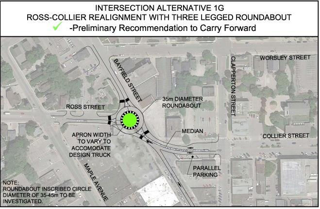
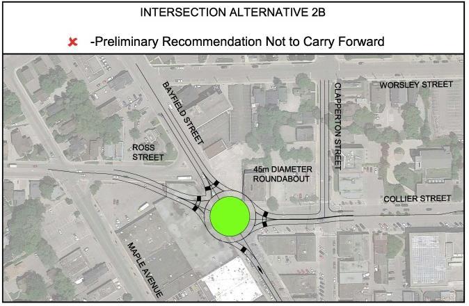
23 intersection (carried forward as Alternative C); Alternative 1B to 1D: Four-leg roundabout with relocation of intersecting roadways (not carried forward); Alternative 1E: Three-leg roundabout (not carried forward); Alternative 1F and 1G: Three-leg roundabout (carried forward as Alternative E and F, respectively; Alternative 2A:Realignment of Ross to Collier with a signalized intersection (carried forward as Alternative D); Alternative 2B: Roundabout with relocation of intersecting roadways (not carried forward); Alternative 2C: Roundabout with relocation of intersecting roadways (45 m diameter) (carried forward as Alternative G). Alternative 2D: Roundabout with relocation of intersecting roadways (35 m diameter) (carried forward as Alternative H); Alternative 3: Block roundabout; and, Alternative 4: Roadway realignment of Ross and Collier using one-way east/west roadways with provision for green space or parking. do not accommodate turning movements. The alternatives carried forward were renumbered as alternatives A to H as presented in Figure 6, Figure 7 and Figure 8. These carried forward alternatives may have a 35 m, 40 m or 45 m radius, shown in Figure 9. Those alternatives not carried forward are due to a limited amount of geometric space available to accommodate individual legs of the roundabout, do not provide sufficient left turn storage and/or 20


24 City of Barrie Ross/Collier/Bayfield Streets EA Study Figure 5: Long List of Ross/Collier/Bayfield Intersection Alternatives 21


25 Figure 6: Carried Forward Intersection Alternatives A, B and C 22


26 Figure 7: Carried Forward Intersection Alternatives D, E and F 23


27 Figure 8: Carried Forward Intersection Alternatives G and H 24

28 Figure 9: Range of Roundabout Inscribed Circle Diameters under Design Consideration 25
29 Road Improvements for Active Transportation Road improvement alternatives for active transportation will include but not be limited to the following: Raised cycle tracks and sidewalks on both sides of Ross Street; Shared bike/vehicular lane; Dedicated bike lanes ( m) and sidewalks on both sides of Ross Street; Two cross-section alternatives for Ross Street will be carried forward for evaluation and are shown in Figure 10.These alternatives carried forward would facilitate the implementation of the MMATMP recommendations. Widen to the south. Based on the level of adjacent development, a preliminary recommendation is to carry forward equal widening on each side (widen on centre). This preliminary recommendation will be presented at PIC 2 for public comment. Sidewalk Alternatives The sidewalk alternatives will include but are not limited to the following: 1.5 m sidewalk; 1.8 m sidewalk; and, 2.0 m sidewalk. As the implementation of the intersection improvements is beyond the 10-year capital plan, altenratives are being studied that would facilitiate the implementation of the MMATMP recommendations as an interim condition. The two alternatives carried forward for evaluaton for Collier Street are illustrated in Figure 11. One alternative is being carried forward for Bayfield Street and is illustrated in Figure 12. Road Alignment Alternatives Road alignment alternatives for Ross Street includes the following: Widen to the north; Widen on the centre; and, 26
30 Figure 10: Ross Street Preliminary Alternative Concepts 27
31 Figure 11: Collier Street Preliminary Alternative Concepts 28
32 Figure 12: Bayfield Street Preliminary Alternative Concepts 29
33 Figure 13: TAC Sidewalk Requirements 30
34 6.0 Preferred Design Criteria The design criteria for Bayfield Street and Ross/Collier Streets are illustrated in Table 1 and Table 2. Table 1: Design Criteria for Bayfield Street Road Class Arterial Posted Speed km/h Design Speed km/h Minimum Horizontal Curve Radius 130 m Maximum Superelevation 4 % Minimum Vertical Crest Curve: Crest: Sag (headlight control): K=24 K=20 Stopping Sight Distance 100 m Lane Width 3.5 m Bike Lane m Shared Bicycle Lane 4.5 m Sidewalks 1.5 m to 2.0 m Right-of-way 20m (Collier to Ross) Side Street Day-Lighting Distance Triangles: 5 m (arterial to minor collector/local) 10m (arterial/major collector to arterial) Watermain Cover to Obvert (common) 1.7 m Storm Cover to Obvert (common) 1.5 m Sanitary Cover to Obvert (common) 2.5+ m or 2% from basement elevation Truck Route Yes Boulevard 1.0 minimum Continuous Two Way Left Turn Lane 4.0 m Table 2: Design Criteria for Collier Street Road Class Major Collector Posted Speed km/h Design Speed km/h Minimum Horizontal Curve Radius 130 m Maximum Superelevation 4 % Minimum Vertical Crest Curve: Crest: Sag (headlight control): K=24 K=20 Stopping Sight Distance 100 m Lane Width 3.5 m Bike Lane 1.5 m Shared Bicycle Lane 4.5 m 31
35 Sidewalks Right-of-way Side Street Day-Lighting Distance Triangles: Watermain Cover to Obvert (common) Storm Cover to Obvert (common) Sanitary Cover to Obvert (common) Truck Route Boulevard Continuous Two Way Left Turn Lane 1.5 m to 2.0 m 30 m 5 m (local to major collector) 10m (major collector to arterial) 1.7 m 1.5 m 2.5+ m or 2% from basement elevation Yes 1.0 minimum 4.0 m Table 3: Design Criteria for Ross Street Road Class Major Collector Posted Speed km/h Design Speed km/h Minimum Horizontal Curve Radius 130 m Maximum Superelevation 4 % Minimum Vertical Crest Curve: Crest: Sag (headlight control): K=24 K=20 Stopping Sight Distance 100 m Lane Width 3.5 m Bike Lane 1.5 m Shared Bicycle Lane 4.5 m Sidewalks 1.5 m to 2.0 m Right-of-way 27 m Side Street Day-Lighting Distance Triangles: 5 m (local to major collector) 10m (major collector to arterial) Storm Cover to Obvert (common) 1.5 m Sanitary Cover to Obvert (common) 2.5+ m or 2% from basement elevation Truck Route Yes Truck Route Yes Boulevard 1.0 minimum Continuous Two Way Left Turn Lane 4.0 m 32
36 7.0 Preliminary Design Considerations The existing conditions in the study area present a variety of issues and constraints for the improvements to Ross/Collier/Bayfield Streets. Issues in the study area include: Transportation and Structures: Accommodate major desire lines for vehicular and transit vehicles from Ross Street and Collier Street. The alternatives must accommodate requirements for access to businesses during and post construction. Accommodate wheel tracking of trucks and transit vehicles. Traffic capacity (accommodating turning movements). Accommodating safe active modes of transportation will be a focus (pedestrian friendly streetscapes and connectivity for cyclists are recognized as key components) Conflicts between bicycle lanes and existing on-street parking along Bayfield Street Traffic impacts of design alternatives The investigation and evaluation of minor and major gateways in the project area and the feasibility and impact of roundabouts and signalized intersections. Utilities: Condition and capacity of the existing storm and sanitary sewers in the study area Evaluation of future capacity requirements for storm and sanitary sewers Location of existing utility conflicts within the study area. Social Environment: Disturbances to businesses during construction. Protection and mitigation of negative effects on existing commercial buildings during construction. Considerations for vulnerable road users (pedestrians, cyclists etc.). Potential property impacts to commercial properties and potential encroachment on privately owned land. Potential impacts to development potential. Potential for archeological and heritage sites. Landscaping/Streetscaping which will include an assessment of existing features and planning of new landscaping and potential street furniture to increase aesthetics and historical significance. Natural Environment: Stormwater best management practices for widened roadways and consultation with the City. 33

 limits available queuing space and opportunities for")
37 Engineering: Future right-of-way protection to accommodate utilities and services, stormwater management, sidewalks, curbs and cycling facilities. Geometric Design Standards and potential horizontal and vertical alignment adjustments. Investigation of existing commercial properties and the impact and control of any hazardous or deleterious materials used in their operations (including the effect of new construction). The proximity and operations of adjacent signalized intersections (such as the Barnes Dance/Pedestrian Phasing at Bayfield/Dunlop/Clapperton) limits available queuing space and opportunities for coordination. Potential signalization or roundabout at Ross Street/Collier Street. Photo 2: Existing Ross/Collier/Bayfield Street Intersections Economics: Capital costs including property acquisition. Life cycle costs including operations and maintenance costs. Photo 1: Adjacent Intersections Evaluation and alternatives of using innovative design throughout the project area, including but not limited to LID techniques and innovative materials. 34