Free Bridge Congestion Relief Project: Using FHWA s Eco-Logical Process
|
|
|
- Dustin Hubbard
- 5 years ago
- Views:
Transcription


1 Free Bridge Congestion Relief Project: Using FHWA s Eco-Logical Process An Ecosystem Approach to Developing Infrastructure Projects June 27, 2014 Charlottesville Albemarle Metropolitan Planning Organization (CAMPO) and The Thomas Jefferson Planning District Commission


2 Introduction: History of Eco-Logical Federal Highway Administration, in partnership with other Federal infrastructure and environmental agencies developed Eco-Logical in response to the 2002 Executive Order Environmental Stewardship and Transportation Infrastructure Project Reviews. The Eco-Logical approach relies on enhanced cooperation between transportation and regulatory agencies to more effectively link transportation system planning with natural and cultural resource concerns Free Bridge: Developed as one of the first Eco-logical pilot projects Collaboration of Albemarle Board of Supervisors Charlottesville Area Transit Charlottesville Bike + Pedestrian Safety Commission Citizens City Planning Commission City Parks and Recreation County Planning Commission Department of Conservation and Recreation Department of Environmental Quality Department of Game and Inland Fisheries Department of Historic Resources Federal Highway Administration JAUNT Lewis and Clark Exploratory Center Martha Jefferson Hospital Piedmont Environmental Council Rivanna Conservation Society Sierra Club Southern Environmental Law Center Streamwatch US Corps of Engineers US Fish and Wildlife Service Virginia Department of Transportation 2


3 Eco-Logical Grant: To help guide agencies and partners to work proactively in developing and implementing an ecosystem approach for mitigating the effects of infrastructure projects- the public works that provide the basic facilities and services on which communities depend. To test the Eco-Logical approach for infrastructure planning and development on a local scale. Increase awareness of Eco-Logical approach among federal, state, and local transportation and resources agencies. Assess and develop the Regional Eco-Logical Framework Tool.


4 Regional Eco-Logical Framework What: Why: How: Inventory of resources of regional significance that form the ecological framework To establish an ecological blueprint that can inform future planning of all types Collect available natural resources from diverse sources. Apply valuations to data that indicate biodiversity, rarity, and quality of existing resources. Prioritizing mitigation sites Depiction of how the spatial analyst analyzes raster data


5 Regional Eco-Logical Framework The Regional Ecological Framework tool was developed by TJPDC with funding from FHWA. The Tool is made up of ten environmental spatial datasets which were included at the suggestion of an advisory committee. The tool was built using GIS and is designed to function in GIS It consists of a rasterized heat map Uses existing GIS functions and tools to conduct analyses. Made up of 10 different spatial environmental datasets overlaid spatially Datasets and attributes ranked then aggregated to form the heat map 5


6 Regional Eco-Logical Framework Built with existing datasets Tiered Species Habitat Threatened and Endangered Species Waters Species observations Natural Landscape Assessment Cores and Corridors Priority Conservation Sites Important Bird Areas National Wetlands Inventory VCLNA Watershed Integrity Model Cold Water Stream Survey National Hydrography Dataset Ranking system: 2 52 High scores representing highest value ecosystem Prioritizes preservation for ecosystem areas (especially wetlands) Free Bridge 6

7 Free Bridge Problem: The US 250 link across the Rivanna River known locally as Free Bridge. This bridge is a key connection for local and regional traffic, but continued use of this link will result in more congestion, economic development and public safety issues that must be addressed. Goal: To find a project option that will alleviate these congestion, economic development, and public safety issues but will do so with the least costs to environmental, social and cultural resources. Traffic Projections ,500 vehicles per day Level of Service: E/F ,000 vehicles per day Level of Service: F 180 hours of delay per day Rendering of a F Level of Service


8 History of Free Bridge Constraints of topography and development make capacity improvements to US250 very expensive. Eco-logical: flexible approach to identify best alternative. Allows MPO to implement a stakeholderdriven process. Previously Discussed Solutions South Pantops Drive 2-Lane Eastern Connector 4-Lane Eastern Connector Limited Access on 250 State Farm Boulevard Widening US 29/250 & 64 Pantops: 1957 Pantops:

9 Eco-Logical s Application to Free Bridge What: Why: How: Development of decision support tools to assist public officials, decision makers, planners, administrators, and the public in reducing conflicts between the built environment and ecosystems. Ecosystem services are provided by green infrastructure. Cost avoidance and revenue are also considerations. Integrate infrastructure and natural resources plans. Allow the Regional Ecological Framework to inform project alternatives. Strategically identify mitigation projects that provide the maximum ecological benefit for the dollars spent. 9
10 Process: Stakeholder Input Session Discuss issues and history of Free Bridge Stakeholders identify transportation alternatives. Group as a whole selects no more than 10 alternatives for analyses by engineering firm. Feasibility and cost (engineering) Engineering firm will analyze 10 alternatives, develop project cost estimates and construction feasibility reports. REF modeling TJPDC staff will take results from the engineers study and run the viable alternatives through the Regional Ecological Framework tool. Staff will produce a detailed report highlighting transportation benefits and environmental costs for each feasible alternative. Stakeholder Input Session TJPDC staff will present the results of the engineering study and REF modeling to stakeholders. Stakeholders will review alternatives and suggest alternatives to move forward with. 10
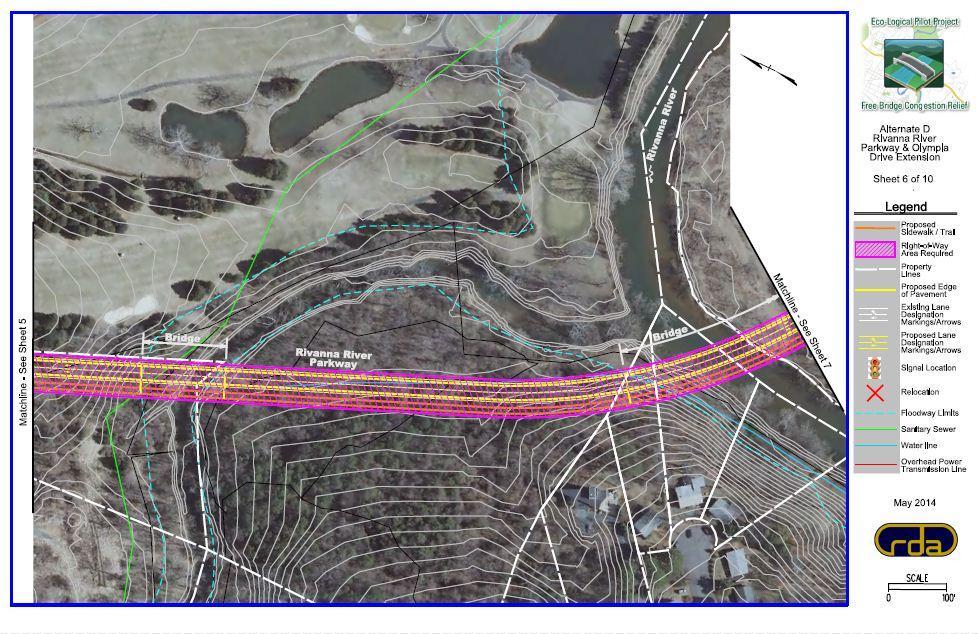
11 Stakeholder Alternatives A: Free Bridge Overpass and Intersection Improvements at US 250 and High Street B: Transit, Park and Ride, and Bike/Pedestrian D: Rivanna River Parkway F: HOV/Reversing lane on US 250 Free Bridge G: South Pantops Drive Connector Bridge I: Intersection improvements at US 250/Route 20 Alternative Construction Feasibility Cost A Low $$$ B Moderate $$ D Moderate $$$ F Moderate $ G High $$ I High $ 11
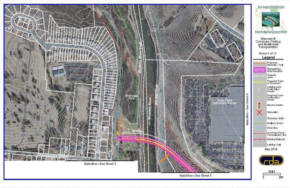
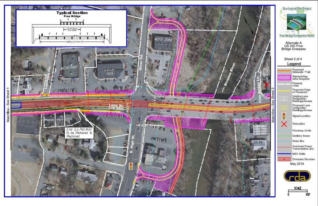
12 A B D
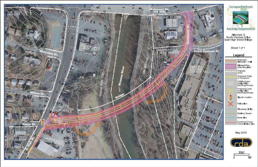
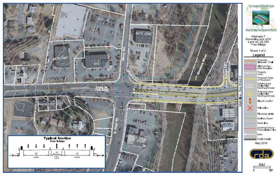
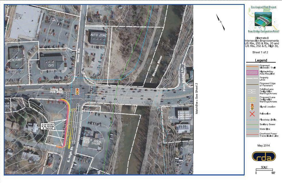
13 F G I 13
14 Next Steps Cost Estimation RDA will be developing cost estimates based on the revised alternatives. These cost estimates will be presented at the July 16 th stakeholder team meeting. REF Tool Analysis The REF Tool is currently being redeveloped based on input from the stakeholders and state environmental agencies. Transportation Modeling Analysis The MPO is currently work with VDOT to use the MPO s Travel Demand Model to model the project alternatives that can be modeled. Stakeholder Input & Review The stakeholders will review all the information about the alternatives (Construction Feasibility, Costs, REF Tool Analysis and Travel Demand Modeling Analysis) and, hopefully, select and project(s) to be implemented. Presentation of Selected Alternatives to MPO for consideration in the 2040 LRTP The MPO will consider the stakeholder teams recommendation for inclusion in the 2040 Long Range Transportation Plan. 14

15 Questions? Contact Information: Sarah Rhodes MPO Program Manager Thomas Jefferson Planning District Commission