Whatcom County Code Chapter Critical Areas Regulations: Wetlands, Streams, and Wildlife
|
|
|
- Edgar Hines
- 5 years ago
- Views:
Transcription

1 Whatcom County Code Chapter Critical Areas Regulations: Wetlands, Streams, and Wildlife August 20, 2014 Wayne Fitch Natural Resources Supervisor Erin Page Natural Resources Planner III
2 CAO Basics Title 16, Chapter Effective Date: September 30, 2005 Purpose: to carry out the goals of the Whatcom County comprehensive land use plan and the State of Washington Growth Management Act by protecting the functions and values of critical areas while allowing for appropriate economically beneficial or productive use of land and property. This chapter seeks to maintain harmonious relationships between human activities and the natural environment. (WCC (A))
)")
3 Wetlands There shall be no activity allowed within a regulated wetland or applicable buffer without meeting the mitigation requirements of section [ Mitigation Requirements ] unless the activity is authorized through section [ Activities Allowed Without a Permit ]. (WCC (A))
4 Wetlands Defined those areas that are inundated or saturated by surface or ground water at a frequency and duration sufficient to support, and that under normal circumstances, do support a prevalence of vegetation typically adapted for life in saturated soil conditions. (WCC ) Wetlands are defined by three parameters: Vegetation Soils Hydrology
5 Wetlands Defined (cont.) Vegetation Wetlands are dominated by hydrophytes Hydrophytes are visible plants that are at least periodically deficient in oxygen due to excessive water content Indicator Status Examples of hydrophytic vegetation

6 Skunk Cabbage

7 Red Osier Dogwood
8 Wetlands Defined (cont.) Soils Wetlands are dominated by hydric soils Hydric soils are formed under conditions of saturation, flooding, or ponding long enough during the growing season to develop anaerobic (lacking oxygen) conditions in the upper part Two categories: hydric mineral soils and organic soils

9 An example of hydric soil
 Saturated to the surface for at least two weeks")
10 Wetlands Defined (cont.) Hydrology It has to be wet! (though not necessarily year round) Saturated to the surface for at least two weeks during the growing season (March - October)
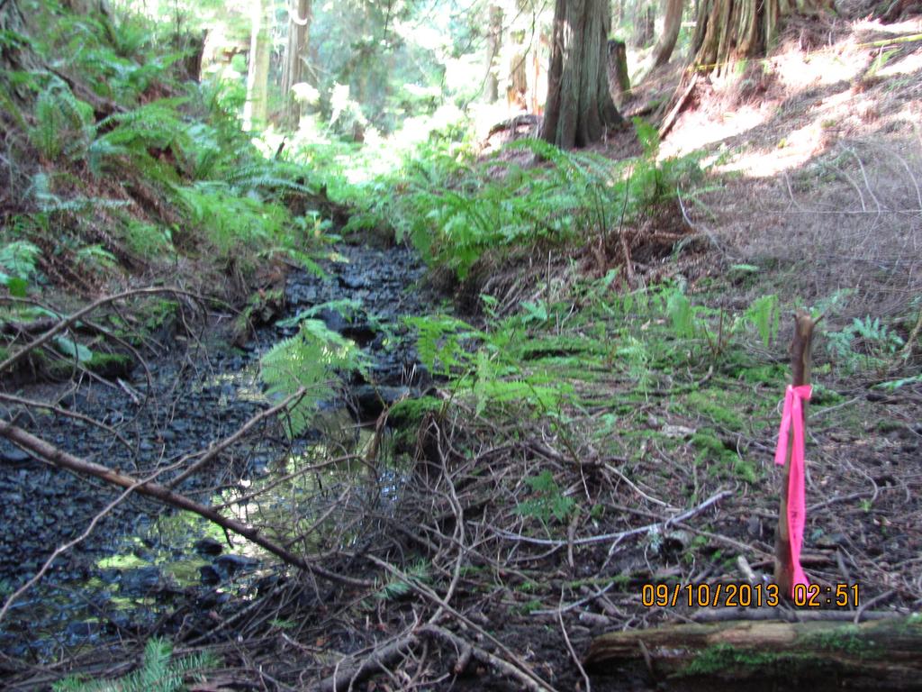
11 Wetlands and how they are delineated Whatcom County has adopted Federal and State laws into the Critical Areas regulations in order to implement these laws on a local level Wetlands have a legal definition that we use to determine if they are regulated or not. It takes training in wetland ecological principles in order to determine. Wetland scientists undergo years of training and are encouraged to become certified Professional Wetland Scientists (PWS) by the SWS Certification Board. An applicant will receive critical areas review in the beginning stages of their permit (Shoreline, NR Assessment, Land Disturbance Permit, etc.). Residents are often surprised as to the presence or extent of wetlands, streams and associated buffers on their property, or their neighbors property And if, or how, these critical areas will restrict their building plans

12 Though this field looks uniformly dry, a wetland was found in this general area
13 What is a Stream? Do you have a ditch on your property that is not part of the County right-of-way? Streams are those areas where surface waters produce a defined channel or bed. A defined channel or bed is an area that demonstrates clear evidence of the annual passage of water and includes, but is not limited to, bedrock channels, gravel beds, sand and silt beds, and defined-channel swales. The channel or bed need not contain water yearround. This definition includes drainage ditches or other artificial water courses where natural streams existed prior to human alteration, and/or the waterway is used by anadromous or resident salmonid or other fish populations or flows directly into shellfish habitat conservation areas.
14
15 Stream and HCA Buffers Shoreline streams: 150 feet Fish-bearing streams: 100 feet Non-fish-bearing streams: 50 feet Buffers for Other Habitat Conservation Areas - The technical administrator shall determine appropriate buffer widths for other habitat conservation areas based on the best available information
16 Why are Buffers so Important? Vegetated wetland buffers function to reduce adverse impacts to water quality by controlling the severity of soil erosion and removing a variety of pollutants from stormwater runoff (Shisler et al. 1987) Large, sudden fluctuations in wetland water levels often destroy wetland vegetation, particularly along the wetland edge (Clark, 1977). Wetland buffers play a role in moderating water level fluctuations Wetland buffers provide essential habitat for wetland-associated species. In Washington, stream buffers and riparian areas provide essential habitat for mammals, birds, amphibians, and reptiles. Vegetated buffers provide visual separation between wetlands and developed environments, blocking glare and human movement from sensitive wildlife (Young, 1989). Buffers also discourage direct human disturbance within a wetland in the form of dumping debris, cutting vegetation, or trampling.
 Generally, the purpose of these areas is to enhance and preserve fish and wildlife and their")
17 Fish and Wildlife Fish and Wildlife are protected under Article VII of the CAO through Fish and Wildlife Habitat Conservation Areas (HCAs) Generally, the purpose of these areas is to enhance and preserve fish and wildlife and their habitat


18 Fish and Wildlife, Cont. Listed Species: those officially designated by the State Department of Fish and Wildlife and/or U.S. Fish and Wildlife Service as endangered, threatened, sensitive, or candidate. red legged frog Bald eagle
 Great blue heron Species of local importance: Vulnerable species: those susceptible to significant population declines because they are uncommon, have a very limited distribution, or have special")
19 Fish and Wildlife (cont.) Great blue heron Species of local importance: Vulnerable species: those susceptible to significant population declines because they are uncommon, have a very limited distribution, or have special space or habitat requirements. Recreationally important species: species with high recreational importance or high public profile and that are vulnerable to habitat loss or degradation.
20 Other HCAs include: Shellfish Habitat Conservation Areas Kelp and Eelgrass Beds, Pacific Herring Spawning Areas Surf smelt and Pacific Sand Lance Spawning Areas Ponds Lakes and Marine Water Bodies Natural Area Preserves

21 Staff Checks for Consistency and BAS, while adhering to Appendix D
22
23 Best Available Science for Critical Areas and Buffers As new research is published about how wetlands and buffers play different functions for habitat, water quality, flood storage, etc., it is important that scientists and planners keep themselves educated in order to protect Whatcom County s resources and find an appropriate balance between development and preservation. CAO allows us to us BAS to ensure there is no net loss of ecological values or functions on site. However, mitigation ratios are generally prescriptive based on the BAS of the current wetland ratings system. Our critical areas code is currently written so that there is room to use best available science as a recommendation tool for mitigation. Mitigation ratios for wetland and HCA buffer impacts are 1:1 per WCC (Standards Habitat Conservation Areas) and WCC (Standards Wetland Buffer Widths). Wetland buffer widths vary depending on the category of the wetland, intensity of the land use, and the habitat value score.
24 Natural Resource Administrative Policies/Procedures and the CAO Update Hazard Tree Removal in Critical Areas Prior Converted Cropland Conversion Policy Farm Plan Disclosure Farm Plan Monitoring and Compliance Conservation Program on Ag Land (CPAL) Animal Threshold Resource Policy Interpretation of non-conforming lot building areas in Shoreline Jurisdiction
25 Flexibilities allowed within wetland General Standards Buffer reduction Buffer averaging Reasonable Use and HCA buffers Variance Alternative Mitigation through a Planned Unit Development or Developers Agreement.
26 Mitigation As discussed previously No activity is permitted within regulated wetlands, rivers, streams, or their associated buffers unless it meets the mitigation requirements of the CAO or is an Activity Allowed Without A Permit Projects shall avoid, minimize, or mitigate for adverse impacts to the functions of regulated critical areas or their buffers by one or more of the following
 Avoid the adverse impact altogether Minimize the adverse impact Rectify the adverse impact (repair, restore or rehabilitate the effected environment) Reduce or")
27 Mitigation (cont.) Avoid the adverse impact altogether Minimize the adverse impact Rectify the adverse impact (repair, restore or rehabilitate the effected environment) Reduce or eliminate the adverse impact over time (preservation) Mitigate the adverse impact by replacing, enhancing or providing substitute resources or environments
28 Mitigation Requirements Mitigation plan shall be prepared by qualified Consultant Assignment of Savings Notice on Title and signage if appropriate Agreement to Maintain mitigation site As-built Report Monitoring 5-10 years or until the mitigation is successful Close mitigation case

29 Linear Review Residential Building Permit Process Pre-Screen for Natural Resource Assessment or Shoreline Permit Natural Resource Team Review (Consolidated Notice of Additional Requirements or Natural Resource Determination)