J O I N T P U B L I C N O T I C E
|
|
|
- Ezra May
- 5 years ago
- Views:
Transcription
1 J O N T P U B L C N O T C E CHARLESTON DSTRCT, CORPS OF ENGNEERS 69A Hagood Avenue Charleston, South Carolina and THE S.C. DEPARTMENT OF HEALTH AND ENVRONMENTAL CONTROL Office of Ocean and Coastal Resource Management 1362 McMillan Avenue, Suite 4 Charleston, South Carolina 2945 REGULATORY DVSON Refer to: PN SAC September 24, 218 Pursuant to Section 1 of the Rivers and Harbors Act of 1899 (33 U.S.C. 43), and the South Carolina Coastal Zone Management Act ( et.seq.), an application has been submitted to the Department of the Army and the South Carolina Department of Health and Environmental Control by Mr. Richard Lee Shipyard Creek Associates, LLC co Mr. Steve Brooks of Brooks Environmental Consulting Services 334 Peachtree Road NE, Suite 6 Atlanta, Georgia 3326 for a permit to construct a public boardwalk in Shipyard Creek at 18 Pittsburgh Avenue, North Charleston, Charleston County, South Carolina (Latitude: N, Longitude: W), Charleston Quad Sheet. n order to give all interested parties an opportunity to express their views N O T C E is hereby given that written statements regarding the proposed work will be received by the Corps until 15 Days from the Date of this Notice, and SCDHEC will receive written statements regarding the proposed work until 3 Days from the Date of this Notice from those interested in the activity and whose interests may be affected by the proposed work. The proposed work consists of the creation of a mixed-use development on the subject property with waterfront dining and retail establishments. Specifically, the in water work consists of
2 REGULATORY DVSON September 24, 218 SAC the construction of a public use boardwalk. The proposed structure would include a 2 x 1,19 fixed timber boardwalk with handrails and benches, five (5) 12 wide access walkways (from North to South) - one at 74 long, one at 128 long, one at 56 long, one at 57 long and one at 13 long), three (3) 24 wide access walkways (from North to South one at 51 long, one at 11 long and one at 4 long), three (3) covered observation platforms (from North to South one at 18 x37, one at 16 x 24 and one at 32 x 33 ), one (1) multi-level covered observation tower (3 x 3 footprint, 2 x 2 covered observation platform, total height of 52.5 above mean low water approximately 43 above the existing grade on the shoreline). No docking facilities are proposed. The applicant has not proposed to mitigate for impacts to wetlands andor waters of the United States. The applicant stated that the project purpose is to facilitate public access along the shoreline to observe and appreciate the waters of Shipyard Creek. NOTE: This public notice and associated plans are available on the Corps website at: The District Engineer has concluded that the discharges associated with this project, both direct and indirect, should be reviewed by the South Carolina Department of Health and Environmental Control in accordance with provisions of Section 41 of the Clean Water Act. The work shown on this application must also be certified as consistent with applicable provisions of the Coastal Zone Management Program (15 CFR 93). This activity may also require evaluation for compliance with the S. C. Construction in Navigable Waters Permit Program. State review, permitting and certification is conducted by the S. C. Department of Health and Environmental Control. The District Engineer will not process this application to a conclusion until such certifications are received. The applicant is hereby advised that supplemental information may be required by the State to facilitate the review. This notice initiates the Essential Fish Habitat (EFH) consultation requirements of the Magnuson-Stevens Fishery Conservation and Management Act. mplementation of the proposed project would impact.76 acre of estuarine substrates and emergent wetlands utilized by various life stages of species comprising the shrimp, and snapper-grouper management complexes. The District Engineer s initial determination is that the proposed action would not have a substantial individual or cumulative adverse impact on EFH or fisheries managed by the South Atlantic Fishery Management Council and the National Marine Fisheries Service (NMFS). The District Engineer s final determination relative to project impacts and the need for mitigation measures is subject to review by and coordination with the NMFS. Pursuant to the Section 7 of the Endangered Species Act of 1973 (as amended), the Corps has reviewed the project area, examined all information provided by the applicant, and the District Engineer has determined, based on the most recently available information that the project would have no effect on the Green sea turtle (Chelonia mydas), Kemp s Ridley sea turtle (Lepidochelys kempii), Leatherback sea turtle (Dermochelys coriacea), Loggerhead sea turtle (Caretta caretta), Shortnose sturgeon (Acipenser brevirostrum) and Atlantic sturgeon (Acipenser oxyrinchus oxyrinchus). Additionally, the proposed project is not likely to adversely affect the West ndian manatee (Trichechus manatus) or the wood stork (Mycteria americana). Furthermore, the District Engineer has determined that the proposed project would not result in the destruction or adverse modification of designated or proposed critical habitat. This public notice serves as a request for written concurrence from the U.S. Fish and Wildlife Service andor the National Marine Fisheries Service on this determination. 2
3 REGULATORY DVSON September 24, 218 SAC Pursuant to Section 16 of the National Historic Preservation Act (NHPA), this public notice also constitutes a request to ndian Tribes to notify the District Engineer of any historic properties of religious and cultural significance to them that may be affected by the proposed undertaking. n accordance with Section 16 of the NHPA, the District Engineer has consulted South Carolina ArchSite (GS), for the presence or absence of historic properties (as defined in 36 C.F.R. 8.16)(l)(1)), and has initially determined that no historic properties are present; therefore, there will be no effect on historic properties. To ensure that other historic properties that the District Engineer is not aware of are not overlooked, this public notice also serves as a request to the State Historic Preservation Office and any other interested parties to provide any information they may have with regard to historic properties. This public notice serves as a request for concurrence within 3 days from the SHPO (andor Tribal Historic Preservation Officer). The District Engineer s final eligibility and effect determination will be based upon coordination with the SHPO andor THPO, as appropriate and required and with full consideration given to the proposed undertaking s potential direct and indirect effects on historic properties within the Corps-identified permit area. Any person may request, in writing, within the comment period specified in this notice, that a public hearing be held to consider this application. Requests for a public hearing shall state, with particularity, the reasons for holding a public hearing. The decision whether to issue a permit will be based on an evaluation of the probable impact including cumulative impacts of the activity on the public interest. The benefit which reasonably may be expected to accrue from the project must be balanced against its reasonably foreseeable detriments. All factors which may be relevant to the project will be considered including the cumulative effects thereof; among those are conservation, economics, aesthetics, general environmental concerns, wetlands, historic properties, fish and wildlife values, flood hazards, flood plain values, land use, navigation, shoreline erosion and accretion, recreation, water supply and conservation, water quality, energy needs, safety, food and fiber production and, in general, the needs and welfare of the people. A permit will be granted unless the District Engineer determines that it would be contrary to the public interest. n cases of conflicting property rights, the Corps cannot undertake to adjudicate rival claims. The Corps is soliciting comments from the public; Federal, state, and local agencies and officials; ndian Tribes; and other interested parties in order to consider and evaluate the impacts of this activity. Any comments received will be considered by the Corps to determine whether to issue, modify, condition or deny a permit for this project. To make this decision, comments are used to assess impacts on endangered species, historic properties, water quality, general environmental effects, and the other public interest factors listed above. Comments are used in the preparation of an Environmental Assessment andor an Environmental mpact Statement pursuant to the National Environmental Policy Act. Comments are also used to determine the need for a public hearing and to determine the overall public interest of the activity. 3
4 REGULATORY DVSON September 24, 218 SAC Please submit comments in writing, identifying the project of interest by public notice number, to the following address: U.S. Army Corps of Engineers ATTN: REGULATORY DVSON 69A Hagood Avenue Charleston, South Carolina f there are any questions concerning this public notice, please contact Courtney M. Stevens, Project Manager, at (843)
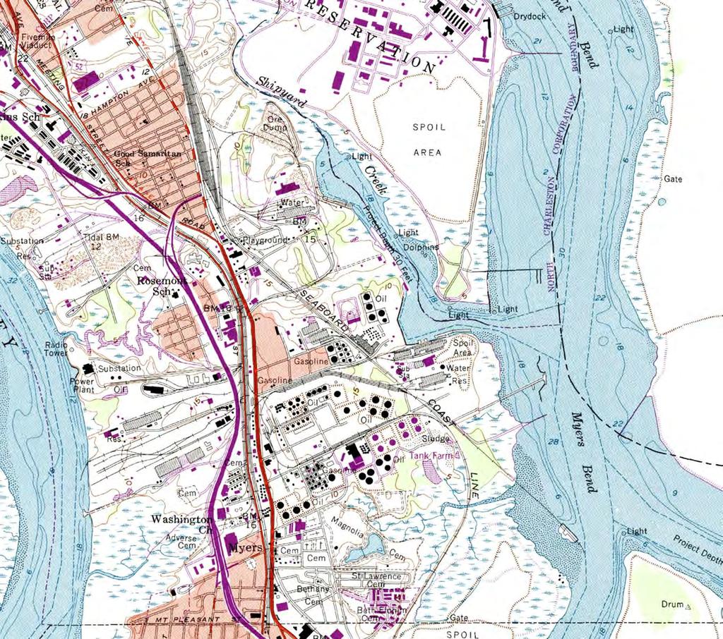


5 SAC Shipyard Creek Boardwalk Sheet 1 September 21, 218

6 ',!(...,:;A,._,,.,, 't1 -, Cl1Y OF NORTH CHARLESTON,... 4.::;.. : fl A' - l PROJECT LOCATON r; - ", "?. or. -r- -' i;- ' 1 ' ' f;. )> '"'ff "'rill "'"' -< :: - cr :: ( " '.., ',,,' 1Jf.7 -? { r:1-ii - :: - -,..,_,..... 'J. J.t "': -.. i P r>p9lli 'f'11btc c-- l>_.. _... DATU.M: "MLW- -'... - Cl1Y OF CHARLESTON -- SOURCES: 1. USGS 7.5 MN. TOPOGRAPHC QUADRANGLE 'CHARLESTON. SC". OBTANED FROM SCDNR GS DATABASE. FOR PERMTTNG PURPOSES ONLY. NOT FOR CONSTRUCTON. - - NORTH _..._ 1., SCALE: 1" = 2,'... cc-e-ss_b_o_a_rd_w_a_l_k p-r--po_s_t_d_: -P-US_U_C_B_OA_R_O_W_A_lK--- APPLCATON BY: SHPYARD CREEK ASSOCATES. llc USACE J: N A f ADJACENT PROPERTY OWNERS: SEE EXHBT B DATE: 6618 LOCATON MAP SHPYARD CREEK ASSOCfA TES, LLC 334 PEACHTREE RD. NE. STE. 6 ATLANTA, GA 3326 AT: 18 PTSBURGH AVENUE ANO SHPYARD CREEK COUl'TY Of: CHARLESTON STATE: SOUTH CAROLNA SHEET 1
7 SAC Shipyard Creek Boardwalk Sheet 3 September 21, 218
8 APPROX. ' LMTS OF MARSH VEGETATON r ' '-.. '.- PROPOSED 2' x 1, 19' BOARDWALK WTH (3) COVERED OBSERVATON PLATFORMS, (1) COVERED OBSERVATON TOWER AND (8) ACCESS WALl<JlAYS. SEE SHEETS 4AND 5 FOR DMENSONS. ', ' ETS ,;,,:- f ' 1 11_ ( lp:lpt --- -focj-- EXSTNG CONCRETE BOAT RAMP TO REMAN -5-1 >'1 f:c1-f1fi:;i:; [ --- ", p",., ADJACENT PROPERTY OWNER (TYP.) SEE EXHBT B.. _J' NORTH 4. FOR PERMTTNG PURPOSES ONLY NOT FOR CONSTRUCTON. APPLCATON BY: SHPYARD CREEK ASSOC ATES, LLC USACE #: N A ADJACENT PROPERTY OWNERS: SEE EXHBT 8 DATE: PROPOSED: PUBLC BOARDWALK PURPOSE: PUBLC ACCESS BOARDWALK DATUM: MLW 1 SCALE: 1" = 2' PROPOSED MPROVEMENTS SHPYARD CREEK ASSOCATES, LLC 334 PEACHTREE RD. NE, STE. 6C ATLANTA, GA 3326 SAC Shipyard Creek Boardwalk AT: 18 PTTSBURGH AVENUE AND Sheet 4 SHPYARD CREEK September 21, 218 COUNTY OF: CHARLESTON STATE: SOUTH CAROLNA SHEET 3
9 ... CRTCAL, N: E: PROPERTY LNE AND MLW LNE 17' J.. " N: E: A 122' 2' (T't N: E: PROPOSED 18' x 37' COVERED OBSERVATON PLATFORM (485 SF) o' 'n <}_ %1. -z_ SHPYARD CREEK ASSOCATES, LLC TMS# N: E: PROPOSED 2' x 1,19' BOARDWALK 12' N: E: N: E: NOTES: BASE NFORMATON COMPLED FROM SURVEYS PERFORMED BY GEL ENGNEERNG, LLC. 2. SOUNDNGS SHOWN ARE EXSTNG, MEASURED N FEET, AND REFERENCED TO MEAN LOW WATER (MLW). DATE OF BATHYMETRC SURVEY: MAY SEE SHEET 5 FOR ENLARGED VEWS OF SOUTHEASTERN PORTON OF NORTH PROPOSED BOARDWALK SEE SHEET 6 FOR CROSS SECTON A - A. SEE SHEET 7 FOR CROSS SECTON B - B. 4. PROPOSED UPLAND STE PLAN S CONCEPTUAL N NATURE AND 5 1 SUBJECT TO CHANGE PENDNG LOCAL APPROVALS AND FNAL DESGN. SCALE : 1" = 1' FOR PERMTTNG PURPOSES ONLY. NOT FOR CONSTRUCTON. " "'" PURPOSE: PUBLC ACCESS BOARDWALK DATUM: MLW APPLCATON BY: SHPYARD CREEK ASSOCATES, LLC USACE #: N A ADJACENT PROPERTY OWNERS: SEE EXHBT 8 DATE: 6618 PROPOSED: PUBLC BOARDWALK SAC PROPOSED MPROVEMENTS Shipyard Creek Boardwalk ENLARGED VEW AT: 18 PTTSBURGH AVENUE AND Sheet 5 September 21, 218 SHPYARD CREEK SHPYARD CREEK ASSOCATES, LLC 334 PEACHTREE RD. NE, STE. 6C COUNTY OF: CHARLESTON ATLANTA, GA 3326 STATE: SOUTH CAROLNA SHEET 4
10 ' '. N: E: PROPOSED 3' x 3' COVERED OBSERVATON N: E: PROPOSED 2' x 1,19' BOARDWALK PROPOSED 16' x 24' COVERED OBSERVATON PLATFORM (335 SF) N: E: N: E: N: E: PROPOSED 32' x 33' COVERED OBSERVATON., PLATFORM (71 SF) N: E: N: E: ) '-- "' :1t.,ll;ig 1 1 1# NOTES: 1. BASE NFORMATON COMPLED FROM SURVEYS PERFORMED BY GEL ENGNEERNG, LLC. 2. SOUNDNGS SHOWN ARE EXSTNG, MEASURED N FEET, AND REFERENCED TO MEAN LOWWATER (MLW). DATE OF BATHYMETRC SURVEY: MAY SEE SHEET 6 FOR CROSS SECTON A - A. SEE SHEET 7 FOR CROSS SECTON B - B. SEE SHEET 8 FOR ELEVATON C - C. 4. PROPOSED UPLAND STE PLAN S CONCEPTUAL N NATURE AND SUBJECT TO CHANGE PENDNG LOCAL APPROVALS AND FNAL DESGN.. NORTH FOR PERMTTNG PURPOSES ONLY. NOT FOR CONSTRUCTON. EXSTNG CONCRETE BOATRAMP 'To REMAN 5 SCALE : 1" 1 = 1' ""' "'2 o PROPOSED: PUBLC BOARDWALK PURPOSE:. PUBLfC ACCESS BOARDWALK DATUM : MLW APPLCATON BY: SHPYARD CREEK ASSOCATES, LLC USAGE #: N A ADJACENT PROPERTY OWNERS: SEE EXHBT 8 DATE: 6618 SAC PROPOSED MPROVEMENTS Shipyard Creek Boardwalk ENLARGED VEW AT: 18 PTTSBURGH AVENUE AND SHPYARD CREEK ASSOCATES, LLC Sheet 6 SHPYARD CREEK September 21, 218 OF: CHARLESTON 334 PEACHTREE RD. NE, STE. 6C COUNTY ATLANTA, GA 3326 STATE: SOUTH CAROLNA SHEET 5
11 WDTH VARES: 2<f FOR BOARDWALK, 12' OR 24' FOR ACCESS WAUCWAYS 42" TMBER HANDRAL TMBER DECKNG TMBER BENCH TMBER STRNGER (TYP.) DECK EL.: 9.5 MLW TMBER SPLT PLE CAP MHW (5.5 MLW) VD 88 (3.14 MLW) TMBER PLE (TYP.) APPROXMATE EXSTNG GRADE (VARES) CROSS SECTON A-A SCALE: 1"=4' FOR PERMTTNG PURPOSES ONLY. NOT FOR CONSTRUCTON. PURPOSE: PUBLC ACCESS BOARDWALK PROPOSED: PUBLC BOARDWALK DATUM: MLW CROSS SECTON A - A APPLCATON BY: SHPYARD CREEK ASSOCATES, LLC USACE #: NA ADJACENT PROPERTY OWNERS: SEE EXHBT B DATE: 6618 AT: 18 PTTSBURGH AVENUE AND SHPYARD CREEK ASSOCATES, LLC SHPYARD CREEK 334 PEACHTREE RD. NE, STE. 6 COUNTY OF: CHARLESTON ATLANTA, GA 3326 STATE: SOUTH CAROLNA SHEET 6
12 TMBER STRNGER (TYP.) r---- 2' WDE BOARDWALK COVERED OBSERVATON PLATFORM. DMENSONS VAAY - SEE SHEETS 4AND5 TMBER BENCH (TYP.) TMBER HANDRAL DECK EL.: 9.5 MLW TMBER SPLT PLE CAP MHW (5.5 MLW) --=t"-1--- NAVD 88 (3.14 MLW) MLW(.) TMBER PLE {TYP.) APPROXMATE EXSTNG GRADE (VARES) CROSS SECTON B - B SCALE: 1 "' 1' FOR PERMTTNG PURPOSES ONLY. NOT FOR CONSTRUCTON. PURPOSE: PUBLC ACCESS BOARDWALK PROPOSED: PUBLC BOARDWALK DATUM: MLW CROSS SECTON B - B APPLCATON BY: SHPYARD CREEK ASSOCATES, LLC USACE #: NA ADJACENT PROPERTY OWNERS: SEE EXHBT B DATE: 6618 AT: 18 PTTSBURGH AVENUE AND SHPYARD CREEK SHPYARD CREEK ASSOCATES, LLC 334 PEACHTREE RD. NE, STE. 6C COUNTY OF: CHARLESTON ATLANTA, GA 3326 STATE: SOUTH CAROLNA SHEET 7
13 SAC Shipyard Creek Boardwalk Sheet 1 September 21, 218