Water is a renewable but limited resource. It is renewable because water is constantly circulating through the global water cycle.
|
|
|
- Millicent Barton
- 5 years ago
- Views:
Transcription

1 Our Water Cycle and Sweetwater Wetlands Water - The Most Precious Resource on Our Water Planet Water is a renewable but limited resource. It is renewable because water is constantly circulating through the global water cycle. It is limited because its availability and form are always changing. Water s availability in the form we most rely on fresh liquid varies greatly and is not evenly distributed throughout the earth. The Earth has often been called the water planet because nearly three-fourths of our planet s surface is covered with water. Water is continuously changing its form but the total amount of water on Earth remains constant. Water exists in three forms: solid (ice), liquid (lakes, oceans, rain, etc.), and gas (water vapor, clouds). Ninety-seven percent of the earth s water is in our oceans and seas. The rest is in our polar icecaps and glaciers, rivers and lakes, and groundwater. A small amount is in water vapor and soil moisture. Thus, even on a water planet, only a tiny portion of our water is available for our use as fresh water at any particular time or place. Water is indeed a precious resource.
, condensing to form clouds (condensation), raining or snowing back to the earth")

2 The Water Cycle The water cycle is the continual circulation of water through its various forms, occurring in a predictable pattern. The pattern we are most familiar with includes water rising from the earth in the form of a vapor (evaporation), condensing to form clouds (condensation), raining or snowing back to the earth (precipitation) and flowing downhill over the earth due to gravity (runoff). The global water cycle is far more complex than this model but the same basic processes are constantly occurring all around the earth. Water also cycles on different time scales; it might take one year or it could take millions of years for a single water molecule to come full cycle. Watersheds While the water cycle is a global system, smaller cycles also occur on local levels. To better understand the movement of water on a local scale, it helps to understand our watersheds. The total land area that contributes water to a particular drainage channel (wash, arroyo, or stream) is called its watershed. For example, the rain or snowmelt from Mount Lemmon that flows south into Sabino Canyon belongs to the Sabino Creek watershed. On a larger scale, a community s watershed includes all the land area around it that contributes water to any of its water sources (including rivers, lakes or groundwater aquifers). Unless a system is established that imports water from outside a local area (e.g., Colorado River water via the Central Arizona Project), the water supply of a community comes from the immediate watershed. Because the water cycle is continual, water is constantly being added to a community s watershed and thus its water supply. In Tucson, we have long relied on water from our watershed to percolate through the earth to recharge (add to) our groundwater aquifer currently our main source of water. To understand a watershed, consider a particular watershed to be like a funnel. Any water that falls in the area of the funnel will be channeled into the funnel. Any water that falls beyond the edge of the funnel flows somewhere else and is outside the watershed of the funnel. In nature, the sides of the funnel are similar to the sides of mountains, which shed water downhill toward a particular drainage.

3 Water Cycle Words Crossword Puzzle Directions: Complete the crossword puzzle using the clues below. Refer to the text and glossary if necessary ACROSS 2. an underground geologic formation that contains water 4. the process of a liquid changing to a vapor 9. the process of water moving down through layers of soil and rock 10. water that flows downhill over the earth s surface 11. water found on the earth s surface (as in runoff, rivers, or lakes): water 12. the addition of water to an aquifer 13. the process of a vapor changing to a liquid (as when clouds form) DOWN 1. water that falls to the earth in such forms as rain or snow 3. the total land area that drains to a specific river, wash, or lake 5. effluent that is highly treated and can be used again: water 6. the process of water moving from above to below the earth s surface 7. water found below the earth s surface 8.water that is treated and released by a sewage treatment plant

4 Water Cycle and Sweetwater Wetlands B C D A E F G H Directions: Use the clues from the crossword puzzle to find which water cycle words are needed to correctly label this water cycle diagram. Write the correct letter beside the water cycle word to indicate its location in the diagram. As an example, the first one is done for you. Crossword clue Water cycle word letter location in diagram 6 Down infiltration e 9 Across 4 Across 13 Across 1 Down 12 Across 7 Down 10 ACROSS
.")
5 Tucson s Water Cycle In our local water cycle, precipitation delivers water to our watershed. The runoff infiltrates (moves through) the surface of the soil. Once in the soil, it slowly percolates down to recharge our groundwater aquifer (water occurring below the surface of the earth). Tucson s water supply was originally surface water (water on the earth s surface) flowing primarily in the Santa Cruz River. There was enough runoff that, coupled with the level of our groundwater, the Santa Cruz River kept flowing pretty much year-round. Extensive human use caused surface water in our valley to largely disappear. Our water supply changed from surface water to groundwater, which we pump up with wells. Continued use has caused our groundwater table to drop to such a level that we have started importing water from the Colorado River using the Central Arizona Project (CAP) canal to minimize the impacts of excessive use of groundwater. Tucson s water is always cycling. The mountain ranges surrounding our city continue to funnel water into our watershed. Some of this water percolates down to recharge the aquifer. However, we use more water than is being recharged into our groundwater aquifer. Additionally, we live in a desert. Limited precipitation and high evaporation rates naturally result in water scarcity. Hydrologists are constantly seeking ways to conserve and, more recently, reuse water. Sweetwater Wetlands plays a role in Tucson s water cycle by helping us reuse valuable water. Reclaimed Water The water that we use in our homes and businesses throughout Tucson is primarily a mix of groundwater and CAP water. After we use this water, the resulting wastewater (also called primary effluent) flows to the county sewage treatment plant where it is treated mechanically, biologically and chemically. When it reaches the level of quality set by state and federal environmental standards, it is called secondary effluent. Some of this water is released into the Santa Cruz riverbed. Some is recharged through special basins. And some of this effluent is further treated through a system of filtration and chlorination at Tucson Water s reclaimed water treatment plant. Here, it is cleansed to an even higher level of quality and becomes reclaimed water.

6 Water Cycle and Sweetwater Wetlands A small portion of the secondary effluent is sometimes piped directly to Sweetwater Wetlands for natural filtration. However, Sweetwater Wetlands gets most of its water from the backwash of Tucson Water s reclaimed water treatment plant. (Backwash water is produced when the silica/carbon filters at the plant are cleaned.) Sweetwater Wetlands serves to naturally cleanse and filter this effluent. From the wetlands, it is delivered to the recharge basins, where it filters through 140 feet of soil to the aquifer. The water stored in the ground beneath the recharge basins is pumped up, chlorinated and mixed with the other reclaimed water to be used on city parks, golf courses, street medians and school playgrounds. What s So Special About Reclaimed Water and Sweetwater Wetlands? As our population grows, more water is used, leaving less groundwater available for future use. However, there is more wastewater. Because water is such a vital resource, it makes sense that we should find ways to recycle and reuse this water. Reclaimed water is recycled water, but it is cycled on a time scale for immediate human use. Our reclaimed water has its own system of pipes for delivery throughout Tucson. Most is used to water golf courses, school playgrounds, and parks. Using reclaimed water for irrigation and other activities saves groundwater and CAP water for other needs such as drinking and bathing. Sweetwater Wetland s role in cleaning up our wastewater is small but extremely important. It takes a lot of resources and time to filter effluent through Tucson Water s water treatment plant. Sweetwater Wetlands accomplishes much of the same results but through the natural water cleansing processes that occur in wetlands. At the same time, a habitat is created which supports a diversity of plants and animals that were once common along the Santa Cruz River.
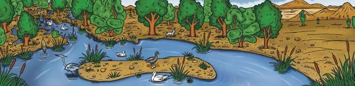
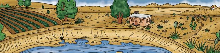
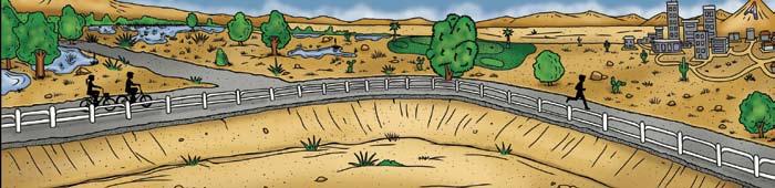
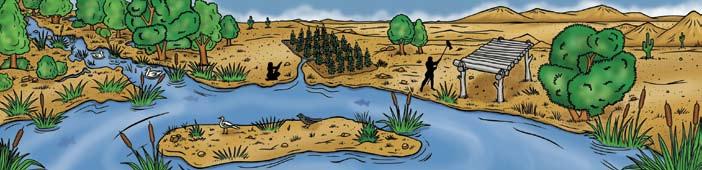
7 History of the Santa Cruz River and Sweetwater Wetlands Sweetwater Wetlands is located on the banks of the Santa Cruz River. Although it is a dry riverbed today, the Santa Cruz once flowed year-round. Construction of the wetlands has restored some of the native habitat that occurred along the Santa Cruz before the 1900 s. Although it is a constructed wetlands, the plants and animals found at Sweetwater Wetlands are typical of the species that were once common along the Santa Cruz River. Directions: The scenes to the right shows changes along the Santa Cruz River over time. Can you put the pictures in order? Use the images and descriptions below for clues! Write the correct date by each picture. When you are done, answer the questions at the bottom of this page s Long ago, the Santa Cruz River flowed year-round in our area. The water table was close to the surface. Beautiful riparian and wetland habitats were found along the river! Many birds and other animals lived in these lush habitats s - The river served as a reliable water source. This drew Native Americans and then other people. These early settlers did not use very much water. The water they did use was replaced by the water cycle. The water table stayed close to the surface s - More people moved to Tucson. They used river water and dug wells. A turning point came near the middle of this century. People began using more groundwater than was replaced by rainfall. The water table fell. The river stopped flowing regularly. Riparian and wetland habitats shrunk s - Tucson grew into a larger and larger city. Because more water was needed for the growing city, people drilled many deep wells. Over time, the water table dropped 200 feet in some areas. The riparian and wetland areas were almost all gone. The beautiful river had become a dry, barren channel. Many plants and animals were lost. early 2000 s - A few years ago, Tucson began using Colorado River water. Also, many parks, golf courses, and school grounds started using reclaimed water. This means that less groundwater is needed. Some wells have been turned off. The water table is rising! Sweetwater Wetlands was built on the banks of the Santa Cruz River. This constructed wetland purifies treated sewage water and provides wildlife habitat. Answer these questions: 1. Describe two differences and two similarities between the scene from the 1500 s and the scene from the 2000 s. Differences: Similarities: 2. Why is there very little difference between the first two scenes? 3. Which illustration shows the most drastic change from the scene before it? Why do you think the change is so drastic? 4.Describe how the scene might look in 50 years from now and explain why it might look like this.

8 Water Cycle and Sweetwater Wetlands DATE: DATE: DATE: DATE: DATE:
 each year. In Tucson, 15 use reclaimed water.")
9 Tucson Basin Diagram: Finding Water In the Desert Directions: It looks like a desert but water is actually everywhere in Tucson.Can you find the following items in this diagram of the Tucson basin? Santa catalina mountains Santa cruz river Just one of these courses uses over 130 million gallons of water (about 200 Olympic size pools) each year. In Tucson, 15 use reclaimed water. Sabino canyon Sweetwater wetlands U of A Jackrabbit Golf course Rillito river San xavier mission Effluent is naturally treated here before entering Tucson s reclaimed water system. Pete the beak Reid park Soccer field Housing development Saguaro cactus This north flowing river once ran year-round and attracted early settlers to Tucson. snake Finger rock Groundwater aquifer Coyote When this mission was built, the Santa Cruz River flowed most of the year. 10

10 These mountains to our north are the main contributor of water in our watershed. A creek flows through this popular recreation area at the base of the Santa Catalina Mountains. This little river flows west and drains into the Santa Cruz River. This park, home of our city s zoo, is kept lush and green with reclaimed water. Along with schools and parks, many of these playing fields use reclaimed water. This institution, like others around town, uses reclaimed water for landscaping. Over 10,000 new homes are built each year in Tucson. The average household in Tucson uses around 270 gallons of water each day. This deep, underground area of rock and sand is the source of most of our drinking water.