Urban Watershed Renewal in Berry Brook: An Examination of Impervious Cover, Stream Restoration and Ecosystem Response
|
|
|
- Carmel Moore
- 5 years ago
- Views:
Transcription


1 Urban Watershed Renewal in Berry Brook: An Examination of Impervious Cover, Stream Restoration and Ecosystem Response Robert Roseen, Tom Ballestero, Melinda Bubier, Joel Ballestero, James Houle, Dean Peschel, Bill Boulanger, David Burdick, Lorie Chase, Viktor Hlas, Ann Scholz, Sally Soule, John Magee, Ben Nugent, Matt Carpenter, University of New Hampshire Stormwater Center, City of Dover, University of New Hampshire, Cocheco River Watershed Coalition, New Hampshire Fish and Game, New Hampshire Department of Environmental Services May 15, 2012 Funding Sources: NHDES 319 Watershed Assistance NHDES Aquatic Resource Mitigation Funds 1
2 Project Objectives This project will foster habitat restoration through urban watershed renewal by restoring and reconnecting a small highly urbanized watershed of a 1st order stream by : 1. Physical restoration by stream and wetland restoration, fish barrier removal, 2. Low Impact Development for base flow augmentation, and water quality improvements. 2
3 Hypothesis Reduction of impervious cover will lead to improvements in stream health as measured by a range of response parameters including: chemical, biological, and hydrologic. Parameter response will vary with respect to time and location 3


4 Impervious Cover and Stream Impairments Source: Impacts of Impervious cover on Aquatic Systems, CWP March Source: Effects of Urbanization on Stream Quality at Selected Sites in the Seacoast Region in New Hampshire, , USGS


5 Stormwater Management LID Systems vs. Common Practice Common Practice Runoff to catch basin Source: Discharge sediment plume Source: 5

 6 Horne St.")
6 Stormwater Management LID Systems vs. Common Practice Bioretention Systems Tedeschi P-Lot (Durham, NH) 6 Horne St. School (Dover, NH)
7 Stormwater Management LID Design Horne St. School Bioretention System Cross-Section Detail 7

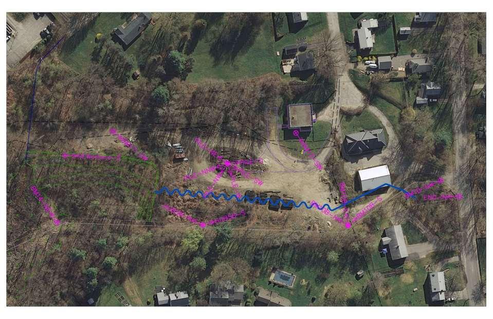
8 Berry Brook Watershed Renewal Project Berry Brook Dover, NH NHDES named Berry Brook to the 303d list of impaired surface waters due to lack of aquatic life support. Current Project Comprises of 2 Components 1) Stream and wetland restoration 2) Stormwater management Berry Brook Watershed Area 185acres 8
9 Experimental Design Watershed Characterization Land Use Impervious Cover Pre- Construction Monitoring Macro Invertebrate Sampling Stream Monitoring- Baseline Conditions Design LID Implementation Construction Examine Watershed Response Water Quality Parameters (Nutrients, TSS, Flow, Temp, Conductivity, IBI) Watershed Model 9

 Source: Adapted from Mapping Impervious Surfaces in the Berry Brook Watershed Complex")
10 Berry Brook Watershed Overview Impervious Surfaces Surface Area (acres) Total Watershed 185 Pervious Asphalt Roads 14.3 Asphalt Driveways 12.4 Compacted Soil 1.0 Parking Lots 7.0 Rooftops 17.6 Other Asphalt 1.7 Other (decks, patios) 1.3 Impervious Total 55.3 (30%) Source: Adapted from Mapping Impervious Surfaces in the Berry Brook Watershed Complex Systems Research Center, August,

11 Response Monitoring 1. Flow, Conductivity, Temperature 2. TSS, Metals, Nutrients, Petroleum Hydrocarbons 3.Fish Species and Abundance 4.Marco invertebrates 13 Source: Google Earth, Imagery 7/4/2009
 Depth,")
 Nutrients,")


12 Data Collection Instruments Aqua TROLL 200 (5) Depth, Conductivity, Temp. ISCO Water Sampler (3) Nutrients, Me, TPH, TSS Surber Sampler (4) Macro Invertebrates Aqua TROLL 200 Surber Sampler Aqua TROLL 200 ISCO ISCO Water Sampler 14 Invertebrate sampling with the Surber
13 TSS & SSC (mg/l) Total Nitrogen & Total Phosphorus (mg/l) Stream-Mile Iron Concentration (mg/l) Nitrate Concentration (mg/l) Stream-Mile Manganese Concentration (mg/l) 10 1 TP & TN Roosevelt-TP Maple-TP Station-TP Data: Pre-Construction Roosevelt-TN 40.0 Maple-Mn Station-Mn Maple-TN Maple-Fe Station-Fe Fe & Mn Stream-Mile Stream-Mile TSS & SSC Roosevelt Maple Station NO Roosevelt-TSS Maple-TSS Station-TSS Roosevelt-SSC Maple-SSC Station-SSC 12 Storms have been observed to date

: Potential for fish to use for thermal refuge, canopy cover")
14 Fish Counts Pre-Monitoring white sucker (1); Orange algae covering stream bottom. Bottom mostly sand. Abundant trash. American eel (1), common sunfish (1), fallfish (5), hatchery brook trout (2), white sucker (1): Potential for fish to use for thermal refuge, canopy cover close to 100% American eel (2), fallfish (10), 16
15 Data: Hypothetical Response Pollutant Response [X] X1 X2 X % Impervious Cover 17
16 Time Line Task Completion Pre-Construction Monitoring June - October 2011 LID Phase 1 Winter LID Phase 2 Spring Fall 2012 Post-Construction Monitoring Fall 2012 Data Analysis Fall 2012 Watershed Model 18 Winter

17 Recreate a stream last seen in the 1800 s 19

18 20


19 21

20 22
21 23
22 24

23 25

24 26

25 27
26 28

27 29

28 30

29 31

30 32

31 33
32 34

33 35

34 36
35 37

36 38

37 39

38 40

39 41
40 42 Hydrology StreamStats Geomorphology Regional Curves Hydraulics HEC-RAS Incipient Motion Shields, LWM Sediment Transport MPM, EB Stream Design Regional equations (Johnson)
41 43 White sucker Brook trout Blacknosed dace Fall fish American eel

42 44
43 45

44 46

45 47
46

47 29 April 2011 BM10-N

48 21 March 2012 BM10-N

49 29 April 2011 BM10B-S

50 21 March 2012 BM10B-S

51 29 April 2011 BM10B-E

52 21 March 2012 BM10B-E

53 29 April 2011 BM10B-N

54 21 March 2012 BM10B-N
55 29 April 2011 BM17-SW

56 21 March 2012 BM17-SW

57 18 August 2011 NEWetland-S

58 21 March 2012 NEWetland-S

59 29 April 2011 Pile-NNW

60 21 March 2012 Pile-NNW

61 29 April 2011 Pile-NW

62 21 March 2012 Pile-NW

63 29 April 2011 Pile-W

64 21 March 2012 Pile-W

65 29 April 2011 Pile-SW

66 21 March 2012 Pile-SW


67 69

68 70

69 71


70 72

71 73

72 74

73 75

74 Thank You 76 Stream Restoration