USGS Watershed Model Evolution RRM(1972) to GSFLOW(2012)
|
|
|
- Gilbert Horton
- 5 years ago
- Views:
Transcription

1 Engineering Conferences International ECI Digital Archives Fifty Years Of Watershed Modeling - Past, Present And Future Proceedings 2012 USGS Watershed Model Evolution RRM(1972) to GSFLOW(2012) George Leavesley USGS, USA Steve Markstrom USGS, USA Follow this and additional works at: Part of the Civil and Environmental Engineering Commons Recommended Citation George Leavesley and Steve Markstrom, "USGS Watershed Model Evolution RRM(1972) to GSFLOW(2012)" in "Fifty Years Of Watershed Modeling - Past, Present And Future", A.S. Donigian, AQUA TERRA Consultants; Richard Field, US EPA (retired); Michael Baker Jr., Inc. Eds, ECI Symposium Series, (2013). This Article is brought to you for free and open access by the Proceedings at ECI Digital Archives. It has been accepted for inclusion in Fifty Years Of Watershed Modeling - Past, Present And Future by an authorized administrator of ECI Digital Archives. For more information, please contact franco@bepress.com.
2 USGS Watershed Model Evolution RRM(1972) to GSFLOW(2012) George Leavesley, USGS Retired and Steve Markstrom, USGS, Denver
3 Model Evolution MMS GSFLOW Time DR3M RRM PRMS Mountain Watershed Model MODFLOW Developers
4 Guiding Principles Integrated Model and System Development Multi-disciplinary integration of models and tools Incorporation of new science advances Open source Modular approach to model development Model composition is function of problem objectives, data constrains, time-space of application Credit Dave Dawdy for planting the seeds of modular design during a grad level class at CSU in early 1970 s
5 Rainfall Runoff Model (RRM) Model Components ANTECEDENT-MOISTURE ACCOUNTING COMPONENT Saturated-unsaturated soil moisture regimes INFILTRATION COMPONENT Philip infiltration equation ROUTING COMPONENT Clark instantaneous unit hydrograph Vars & Params Daily rainfall Daily pan evaporation Initial conditions di/dt = K (1. + (P(m-m 0 ) / i)) Vars & Params Storm rainfall Initial conditions Ksat and P Vars & Params Rainfall excess Time-area curve Linear reservoir coeff Dawdy, D.R., Lichty, R.W., and Bergmann, J.M., 1972, A rainfall- runoff simulation model for estimation of flood peaks for small drainage basins: U.S. Geological Survey Professional Paper 506-B, 28 p.
6 Model Evolution DR3M (Distributed) Time ENHANCEMENTS Green-Ampt infiltration Flow planes and channels Kinematic routing Leclerc, Guy, and Schaake, J.C., Jr., 1973, Methodology for assessing the potential impact of urban development on urban runoff and the relative efficiency of runoff control alternatives: Ralph M. Parsons Laboratory Report no. 167, Massachusetts Institute of Technology, 257 p. RRM (Lumped) Developers
7 Distributed Routing Rainfall Runoff Model (DR3M) Model Features Pervious and impervious area rainfall excess Green-Ampt infiltration equation for rainfall excess Kinematic routing for flow planes and channels Multiple solution techniques for kinematic routing Soil moisture accounting between storms Interflow and baseflow not simulated Snow accumulation and melt are not simulated Dawdy, D.R., Schaake, J.C., Jr., and Alley, W.M., 1978, User's guide for distributed routing rainfall-runoff model: U.S. Geological Survey Water- Resources Investigations Report 78-90, 146 p. Alley, W.M., and Smith, P.E., 1982, Distributed routing rainfall- runoff model--version II: U.S. Geological Survey Open-File Report , 201 p.
8 Distributed Routing Rainfall Runoff Model (DR3M) Flow Planes and Channels EXPLANATION Hydrologic response unit Watershed boundary Stream Direction of streamflow Streamflow gage at basin outlet
9 Mountain Watershed Model Model Features Daily time step Distributed hydrologic response unit (HRU) based Surface runoff computed using contributing area concept Subsurface and groundwater flows computed as nonlinear and linear reservoirs Snow accumulation and melt computed using an energy budget approach Leavesley, G.H., 1973, A mountain watershed simulation model: Fort Collins, Colorado, Colorado State University, Ph. D. dissertation, 174 p.


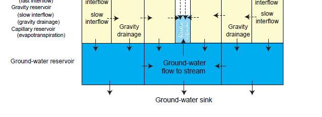
10 Mountain Watershed Model
11 Model Evolution Time DR3M PRMS Mountain Watershed Model Developers
12 Precipitation-Runoff Modeling System (PRMS) Model Features Modular design Integrates daily and storm mode time steps Computes surface, subsurface, and groundwater flow at all time steps User selectable components for ET, precip and temp distribution, surface runoff, and solar radiation computations Includes optimization and sensitivity analysis tools Leavesley, G.H., Lichty, R.W., Troutman, B.M., and Saindon, L.G., 1983, Precipitation-runoff modeling system User s manual: U.S. Geological Survey Water-Resources Investigations Report , 207 p.
13 PRMS
14 PRMS Modular Design Conceptually a great idea Implementation in PRMS, less than desirable Few support tools Coding complexity Spaghetti coding Enter the Modular Modeling System (MMS) Developed in collaboration with the Center for Advanced Decision Support in Water and Environemental Systems (CADSWES), Univ of Colorado, Boulder, CO Leavesley, G.H., Restrepo, P.J., Markstrom, S.L., Dixon, M., and Stannard, L.G., 1996b, The Modular Modeling System (MMS): User s manual: U.S. Geological Survey Open-File Report , 142 p.
15 MMS Developed to Address a Range of Modular Design Levels PROCESS MODEL FULLY COUPLED MODELS LOOSELY COUPLED MODELS RESOURCE MANAGEMENT DECISION SUPPORT SYSTEMS ANALYSIS AND SUPPORT TOOLS


 MMS")

16 MODULAR Model Builder MODELING SYSTEM (MMS) MMS Interface Object User Interface
17 Analysis and Support Tools Integrated with MMS and PRMS The GIS Weasel LUCA A Multi-step multiobjective calibration tool Esemble Streamflow Prediction Data retrieval Downsizer
18 Model Evolution GSFLOW Time PRMS Revised PRMS MODFLOW Developers


19 Conceptual Revised Soil Zone Structure and Flow Computation Sequence
20 A Revision Adds Cascading 21 HRU Flow Paths 1 21 EXPLANATION Hydrologic response unit and numerical identification Watershed boundary Stream Direction of streamflow Direction of runoff and interflow among hydrologic response units Streamflow gage at basin outlet

21 Revised PRMS Conceptualization
22 Coupled Groundwater Surface- Water Flow Model (GSFLOW) Model Features Daily time step Simultaneously simulates flow across the land surface, within subsurface saturated and unsaturated materials, and within streams and lakes 3 simulation modes (integrated, PRMS only, MODFLOW only) allow incrimental setup and calibration Markstrom, S.L., Niswonger, R.G., Regan, R.S., Prudic, D.E., and Barlow, P.M., 2008, GSFLOW Coupled ground-water and surface-water flow model based on the integration of the Precipitation-Runoff Modeling System (PRMS) and the Modular Ground-Water Flow Model (MODFLOW-2005): U.S. Geological Survey Techniques and Methods 6-D1, 240 p.
23 PRMS to SFR2 GSFLOW -- Coupled PRMS, MODFLOW, SFR, and Unsaturated Zone Models Unsaturated Zone Model: PRMS to MODFLOW PRMS to UZF UZF to MODFLOW MODFLOW to SFR2 Streamflow
24 Model Developer Credits Alley, W.M. Barlow, P.M. Bergman, J.M. Dawdy, D.R. Dixon, M. Hay, L.E. Harbaugh, A.W. Lichty, R.W. Markstrom, S.L. Niswonger, R.G. Prudic, D.E. Regan, R.S. Restrepo, P.J. Schaake, J.W. Jr Smith, P.E. Stannard, L.G. Troutman, B.M.
25 In Conclusion Legacy of watershed model development and application that goes back 40 years Responds to the technology and need of the time Many people have contributed