U.S. ARMY CORPS OF ENGINEERS BUILDING STRONG LOS ANGELES DISTRICT
|
|
|
- Jean Conley
- 5 years ago
- Views:
Transcription

1 PUBLIC NOTICE U.S. ARMY CORPS OF ENGINEERS BUILDING STRONG LOS ANGELES DISTRICT APPLICATION FOR PERMIT Surfer s Point Cobble Nourishment Project Public Notice/Application No.: SPL AJS Project: Surfer's Point Cobble Nourishment Project Comment Period: June 4 - June 30, 2013 Project Manager: Antal Szijj; ; Antal.J.Szijj@usace.army.mil Applicant Joe McDermott City of Ventura P.O. Box 99 Ventura, California Contact Richard W. Parsons 2271 Los Encinos Ojai, California Location Pacific Ocean at Surfer s Point in the city and county of Ventura, CA (at: lat N; long W). Activity To place up to 9,600 cubic yards of cobble material along an 800-foot segment of Surfer's Point Beach, adjacent to Seaside Park over a 5-year period in association with Surfer's Point Beach Nourishment Project (see attached drawings). For more information see page 3 of this notice. Interested parties are hereby notified that an application has been received for a Department of the Army permit for the activity described herein and shown on the attached drawing(s). We invite you to review today s public notice and provide views on the proposed work. By providing substantive, site-specific comments to the Corps Regulatory Division, you provide information that support the Corps decision-making process. All comments received during the comment period become part of the record and will be considered in the decision. This permit will be issued, issued with special conditions, or denied under Section 404 of the Clean Water Act and Section 10 of the Rivers and Harbors Act. Comments should be mailed to: Antal Szijj, Senior Project Manager Ventura Field Office 2151 Alessandro Drive, Suite 110 Ventura, CA 93001
2 Alternatively, comments can be sent electronically to: The mission of the U.S. Army Corps of Engineers Regulatory Program is to protect the Nation's aquatic resources, while allowing reasonable development through fair, flexible and balanced permit decisions. The Corps evaluates permit applications for essentially all construction activities that occur in the Nation's waters, including wetlands. The Regulatory Program in the Los Angeles District is executed to protect aquatic resources by developing and implementing short- and long-term initiatives to improve regulatory products, processes, program transparency, and customer feedback considering current staffing levels and historical funding trends. Corps permits are necessary for any work, including construction and dredging, in the Nation's navigable water and their tributary waters. The Corps balances the reasonably foreseeable benefits and detriments of proposed projects, and makes permit decisions that recognize the essential values of the Nation's aquatic ecosystems to the general public, as well as the property rights of private citizens who want to use their land. The Corps strives to make its permit decisions in a timely manner that minimizes impacts to the regulated public. During the permit process, the Corps considers the views of other Federal, state and local agencies, interest groups, and the general public. The results of this careful public interest review are fair and equitable decisions that allow reasonable use of private property, infrastructure development, and growth of the economy, while offsetting the authorized impacts to the waters of the United States. The permit review process serves to first avoid and then minimize adverse effects of projects on aquatic resources to the maximum practicable extent. Any remaining unavoidable adverse impacts to the aquatic environment are offset by compensatory mitigation requirements, which may include restoration, enhancement, establishment, and/or preservation of aquatic ecosystem system functions and services. Evaluation Factors The decision whether to issue a permit will be based on an evaluation of the probable impact including cumulative impacts of the proposed activity on the public interest. That decision will reflect the national concern for both protection and utilization of important resources. The benefit, which reasonably may be expected to accrue from the proposal must be balanced against its reasonably foreseeable detriments. All factors which may be relevant to the proposal will be considered including the cumulative effects thereof. Factors that will be considered include conservation, economics, aesthetics, general environmental concerns, wetlands, cultural values, fish and wildlife values, flood hazards, flood plain values, land use, navigation, shoreline erosion and accretion, recreation, water supply and conservation, water quality, energy needs, safety, food production and, in general, the needs and welfare of the people. In addition, if the proposal would discharge dredged or fill material, the evaluation of the activity will include application of the EPA Guidelines (40 CFR Part 230) as required by Section 404 (b)(1) of the Clean Water Act. The Corps of Engineers is soliciting comments from the public; Federal, state, and local agencies and officials; Indian tribes; and other interested parties in order to consider and evaluate the impacts of this proposed activity. Any comments received will be considered by the Corps of Engineers to determine whether to issue, modify, condition or deny a permit for this proposal. To make this decision, comments are used to assess impacts on endangered species, historic properties, water quality, general environmental effects, and the other public interest factors listed above. Comments are used in the preparation of an Environmental Assessment and/or an Environmental Impact Statement pursuant to the National Environmental Policy Act. Comments are 2
3 also used to determine the need for a public hearing and to determine the overall public interest of the proposed activity. Preliminary Review of Selected Factors EIS Determination- A preliminary determination has been made that an environmental impact statement is not required for the proposed work. Water Quality- The applicant is required to obtain water quality certification, under Section 401 of the Clean Water Act, from the California Regional Water Quality Control Board. Section 401 requires that any applicant for an individual Section 404 permit provide proof of water quality certification to the Corps of Engineers prior to permit issuance. For any proposed activity on Tribal land that is subject to Section 404 jurisdiction, the applicant will be required to obtain water quality certification from the U.S. Environmental Protection Agency. Coastal Zone Management- The applicant has certified that the proposed activity would comply with and would be conducted in a manner that is consistent with the approved State Coastal Zone Management Program. For those projects in or affecting the coastal zone, the Federal Coastal Zone Management Act requires that prior to issuing the Corps authorization for the project, the applicant must obtain concurrence from the California Coastal Commission that the project is consistent with the State's Coastal Zone Management Plan. The District Engineer hereby requests the California Coastal Commission's concurrence or non-concurrence. Essential Fish Habitat- The Corps made a preliminary determination that the proposed activity may adversely affect Essential Fish Habitat, but that the effects would not be substantial. Pursuant to Section 305(b)(2) of the Magnuson-Stevens Fishery Conservation and Management Act (MSA), the Los Angeles District consulted with the National Marine Fisheries Service (NMFS) regarding this preliminary determination. NMFS concurred that the proposed action would have adverse but insubstantial adverse effects on EFH. NMFS further recommended the Corps submit an annual report documenting the volume and extend of any sand or cobble nourishment undertaken in association with the proposed action. This provision would be included as a special condition of the proposed permit. Cultural Resources- The latest version of the National Register of Historic Places has been consulted and this site is not listed. This review constitutes the extent of cultural resources investigations by the District Engineer, and he is otherwise unaware of the presence of such resources. The project area has been subject to past disturbance from cobble placement and is in an active surf zone. For these reasons the likelihood the proposed action would affect any previously unknown cultural resources is extremely unlikely. Endangered Species- Preliminary determinations indicate that the proposed activity would not affect federally-listed endangered or threatened species, or their critical habitat. Critical habitat for the threatened western snowy plover (Charadrius nivosus nivosus) is designated along Buenaventura State beach, approximately 2,000 feet to the east and critical habitat for the endangered tidewater goby (Eucyclogobius newberryi) is designated in the Ventura River estuary, approximately 2,000 feet to the west. The project area is a cobble-dominated beach/surf zone that does not provide suitable habitat for either species. Furthermore, the distance from the project site to areas of suitable habitat for the goby and plover would preclude any indirect effects to either species. Therefore, the Corps 3
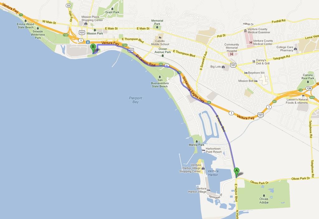
4 has determined the proposed action would not affect any federally listed threatened or endangered species and formal consultation under Section 7 of the Endangered Species Act is not required. Public Hearing- Any person may request, in writing, within the comment period specified in this notice, that a public hearing be held to consider this application. Requests for public hearing shall state with particularity the reasons for holding a public hearing. Proposed Activity for Which a Permit is Required Basic Project Purpose- The basic project purpose comprises the fundamental, essential, or irreducible purpose of the proposed project, and is used by the Corps to determine whether the applicant's project is water dependent (i.e., requires access or proximity to or siting within the special aquatic site to fulfill its basic purpose). The basic project purpose for the proposed project is beach nourishment, which does not require placement of fill in any special aquatic site. No special aquatic sites exist at the project site and the project would not impact any such sites. Overall Project Purpose- The overall project purpose serves as the basis for the Corps' 404(b)(1) alternatives analysis and is determined by further defining the basic project purpose in a manner that more specifically describes the applicant's goals for the project, and which allows a reasonable range of alternatives to be analyzed. The overall project purpose for the proposed project is to control beach erosion in the vicinity of Surfer s Point. Additional Project Information Baseline information- The disposal site is an 800-foot section of beach adjacent to the parking lot at Seaside Park, also known as Surfer s Point. The western portion of the project above the high tide line is owned by the California 31st Agricultural District (operator of the Ventura County Fairgrounds) and has been subject to erosion during storm surges. The eastern portion of the project is owned by the City of Ventura. The City of Ventura is also a trustee of the intertidal land below high tide along the entire project limits. The project area is a cobble-dominated surf zone, which has been prone to erosion in the past. Continued erosion threatens to damage an existing bike and pedestrian pathway and the adjacent parking area. A managed retreat project, which is addressing beach erosion by removing and/or relocating a portion of a parking lot and pathway that were threatened by ongoing erosion, is currently being implemented between the project area and the Ventura River estuary to the west. The project area was not included in the managed retreat plan due to the extent of existing infrastructure that would have to be removed or relocated, including a sewer transfer station, public restroom facility, parking lot and concrete bike path. Erosion continues to present a problem along this 800-foot section of beach. An experimental cobble nourishment project was implemented at the project site in 2000, which provided approximately 10 years of protection to the bike path and other public facilities. Currently, the project area has eroded up to the bike path where there is an immediate drop of about four to five feet from the bike path surface to the beach surface. The City is concerned that future winter storms could erode additional substrate and cause a portion of the bikeway and parking area adjacent to the project area to collapse. Project description- The City is proposing to nourish the beach site with cobble material that is similar in appearance and physical makeup to the existing materials at the beach site, thus increasing the size of the beach surface at this location and protecting the bikeway and parking lot. Cobble would be placed as it becomes available, not to exceed a total of 9,600 cubic yards over the five-year 4
5 life of the permit (equivalent to 14,400 tons or 1,440, 10-yard trucks). The first deposition would attempt to address at least 200-feet of the total 800-foot segment of the beach, which would increase protection for the most severely eroded sections. Subsequent depositions would address the remainder of the beach segment and/or to top off areas that have already been protected and where cobble has settled out or migrated into the ocean. The maximum amount of cobble to be placed in any given year would be 4,800 cubic yards (equivalent to 7,200 tons or 480, 10-yard trucks). The top of the cobble blanket would be recessed approximately two feet below the level of the bike path and filled in with suitable beach sand. The sand topping would extend for a width of about 10 to 15 feet to provide a useable area for beachgoers and a buffer between the bike path and exposed cobble blanket. Sand used for topping the cobble is not expected to remain stationary throughout the year. Wave rush up during storm events at high tide, primarily during winter and early spring months, is expected to wash this sand away and/or into the voids between the cobble underlying the sand layer. The City would replenish this sand layer between the months of April and May of each year over the five-year period in preparation for the summer season. The maximum amount of sand topping in any given year would be 1,000 cubic yards (equivalent to 100, 10-yard trucks). The maximum amount of sand placed over the entire five-year period, which includes replenishing sand that washes away from high tide and storm events, would be 5,000 cubic yards (500, 10-yard trucks). Sand would not be placed below high tide. Beach sand would be obtained from City's stockpile at River Haven located at City owned land near the intersection of Olivas Park Drive and Harbor Blvd approximately 4 miles away (see attached map). This sand stockpile is comprised of beach sand removed from nearby Pierpont Beach and is of suitable color and gradation for beach nourishment. The sand would be screened of any deleterious debris, including vegetation, rocks or concrete debris prior to deposition at the nourishment site. Prior to placing any cobble along the beach, existing debris would be removed to the greatest extent possible. There are large chunks of asphalt, concrete walkway that have collapsed, and similar debris that has fallen into the intertidal zone as a result of the erosion that has occurred along this section of the shoreline. Some of the concrete debris was purposely placed along the shoreline many decades ago in order to provide erosion protection at the time. Access will be limited from the top of the beach or bike path level utilizing a claw attachment on an excavator. Due to access limitations, only debris that is exposed at the surface and that can be reached with the excavator would be removed. Any remaining debris would be covered with the cobble. Prior to covering any cobble, any exposed steel reinforcement would be cut away from concrete rubble. Any removals that leave a void would be expected to naturally fill in with sand or would be filled with the imported cobble. Equipment would consist of one or two track-mounted loaders/excavators that would spread and redistribute cobble piles that are directly deposited onto the beach from hauling trucks. The loaders would be used to spread out and shape the cobble blanket. An excavator with a claw attachment may also be used to lift and place cobble in order to help shape the cobble blanket. The concrete rubble and debris located closer to Figueroa Drain is not being removed as part of this project. This segment of the beach, which is just east of the 800-foot segment proposed for cobble nourishment, contains high volumes of debris and is not being proposed for cobble nourishment at this time as it has been providing protection to the beach from erosion. The City anticipates addressing this area at a future time as part of a separate project. Access to and from this section of shoreline would be from one of the driveways located along Shoreline Drive. Appropriate traffic control devices would be implemented, including warning signs for pedestrians using the bike path, flaggers (as determined necessary), and protective steel plates on 5
6 top of the bike path to protect it from damage from construction equipment. Orange safety fence or similar barriers would be erected to keep pedestrians and beachgoers out of the active work area. The bike path along the Promenade would remain open at all times except for brief intermittent when trucks unload cobble or sand onto the beach. Work hours would be between the hours of 7:00 A.M. to 5:00 P.M. Monday through Friday excluding holidays. No work would occur during the annual Ventura County Fair. The only work to occur outside of the grunion run months of April through August would be for the replenishment of beach sand, which would occur during the months of April through May. Cobble would be imported directly from the cobble source and no stockpile site is proposed in the vicinity of the project. Construction equipment would not be stored within the public right-of-way, nor on the beach during non-work hours. Work in place would be monitored approximately once per year over the five year period. Monitoring would consist of conducting surveys of the surface of sand and cobble that is placed at pre-established transects along the 800-foot section of nourishment. The survey results would determine the extent of any re-nourishment using cobble or sand for any given year. Proposed Mitigation The proposed mitigation may change as a result of comments received in response to this public notice, the applicant's response to those comments, and/or the need for the project to comply with the 404(b)(1) Guidelines. The project is not anticipated to result in any substantial adverse impacts to the aquatic environment, either individually or cumulatively. In consideration of the above, the proposed mitigation sequence (avoidance/minimization/compensation), as applied to the proposed project is summarized below: Avoidance: The proposed action is intended to protect existing infrastructure adjacent to Surfer s Point Beach. Complete avoidance would only be possible with the installation of a seawall or by removing or relocating existing infrastructure. These alternatives would be considered in the Corps alternatives analysis. Minimization: Adverse effects to the area would be minimized through limitations on the timing and volume of material placed along the beach. Material would be properly screened to ensure compatibility with the existing beach composition. Compensation: Compensatory mitigation is not anticipated to be required given the site conditions and nature of the activity. The project would not result in any permanent loss of waters of the U.S. or any special aquatic sites. Proposed Special Conditions The following list is comprised of proposed Permit Special Conditions, which are required of similar types of projects: 1. Discharges of fill material into waters of the U.S. authorized in this permit shall be limited to the volume and cobble/grain size distribution specified on a case-by-case basis. Cobble. No discharge of fill material into waters of the U.S. is authorized for any single proposed project until the Corps Regulatory Division has provided a Final signed notification to proceed (NTP). 2. Prior to each discharge event and in order to receive an NTP authorizing work, the permittee shall prepare a report providing the following information: 6

7 A) Source, volume, size and composition of cobble material B) Need for any Corps permits to obtain material C) Proposed discharge site D) Proposed start and completion dates E) A debris management plan to prevent disposal of unsuitable debris at all beach discharge locations. The debris management plan shall include: sources and expected types of debris, debris separation and retrieval methods, and debris disposal methods. F) A summary of previous discharge events (including dates, quantities and locations) 3. If source material is to be dredged or excavated from waters of the United States, separate authorization under Sections 10 and/or 404 will be required. 4. The Permittee shall implement all appropriate, standard Best Management Practices to ensure that toxic materials, silt, debris, or excessive eroded materials do not enter waters of the U.S. 5. The applicant will establish a safety flag perimeter of the beach nourishment area during disposal activities, and monitor the premises to protect the general public from construction hazards and equipment. 6. No maintenance, storage, or fueling of heavy tracked equipment or vehicles will occur within 500 feet of the high tide line of waters of the U.S. 7. Upon completion of each discharge event, the permittee shall prepare a post-discharge report documenting compliance with the terms and conditions of this permit. Copies of the report shall be provided within 30 calendar days of completion of each discharge event to the Corps of Engineers and the National Marine Fisheries Service. The report shall include: A) Corps permit number B) Quantities and locations of sand and cobble placed C) Survey results documenting pre- and post-discharge elevations D) Actual start date and completion date of transport and discharge operations. E) Summary of any debris removal required as part of the operation For additional information please call Antal Szijj of my staff at or via at Antal.J.Szijj@usace.army.mil. This public notice is issued by the Chief, Regulatory Division. Regulatory Program Goals: To provide strong protection of the nation's aquatic environment, including wetlands. To ensure the Corps provides the regulated public with fair and reasonable decisions. To enhance the efficiency of the Corps administration of its regulatory program. U.S. ARMY CORPS OF ENGINEERS LOS ANGELES DISTRICT Ventura Field Office 2151 Alessandro Drive, Suite 110 Ventura, CA

8

9
10
11