Ury and Fisher s Getting to Yes?? This tale is more about responsibly knowing when getting to no is the right decision to make.
|
|
|
- Joshua Thomas
- 5 years ago
- Views:
Transcription
1 Thanks for the opportunity. Ury and Fisher s Getting to Yes?? This tale is more about responsibly knowing when getting to no is the right decision to make. Focused on minimizing risk and life cycle costs, project plans, phasing and stakeholder impacts are adjusted to improve its feasibility. Port project attributes are influenced by several types of stakeholders such as port authorities, port users, communities and regulatory agencies. Identifying and quantifying impacts to these stakeholders is an initial project feasibility effort typically required by funding entities. 1

2 Feasibility is at the core of our effort to annex West Hayden Island. We ve held the 800 acre property in marine strategic reserve, but when asked by the city we agreed to pursue annexation. Feasibility is guided or informed by CERTAINTY around use, mitigation and enhancement requirements and the ultimate value of the asset. COMMITTMENT to a defined development process with approvals given as part of the annexation process. FLEXIBILITY supports feasibility by allowing for a limited range of specific uses. 2

3 Some context: Portland and the Port of Portland are 100 miles upstream from the Pacific via access and maintenance of a 43 shipping channel in the Columbia River. 3

4 Portland The City of Roses Bi state region includes Vancouver/Clark County in Washington and five counties in Oregon. Portland Metropolitan Area 2014 pop: 2,348,247 4

5 Majority of Port properties are located in Portland located at the confluence of Willamette and Columbia, on the deep draft navigation channel, and upriver barge system, two Class I rail lines/network, and two interstate highways 5

6 The Port consists of public and private terminals handling a wide range of goods for both import and export. Liquid and dry bulks make up the largest tonnage of material handled in the harbor. The four public terminals reflect that tonnage by handling large volumes of grains, soda ash and potash. Auto imports and exports are also important to the Port s business and are handled at Terminal 4 and 6. There is a minimal amount of land available for forecasted expansion and development, especially the demand for large, 100+ acres sites. This information helped drive the West Hayden Island planning process. 6

7 WHI is strategically located at the intersection of two major highways, two rivers and two transcontinental railroads. It is adjacent to existing marine terminals in Portland and across the river in Vancouver Washington. It is also adjacent to: Columbia, Willamette and Columbia Slough waterways High functioning wetlands and open spaces owned by the Port and others. The property was brought into the regions Urban Growth Boundary in 1983, while owned by Portland General Electric, to meet the demand for marine terminal land. The Port purchased it in 1994 for future expansion opportunities. Current county zoning is Multiple Use Forestry with Significant Environmental Concern overlay. This allows for 20 acre housing development or farm and forest uses. 7
8 The current uses on WHI include: 100 acres for dredge material placement (site designated through channel deepening EIS)- City used site for placement of material from the construction of the expansion of the Columbia wastewater treatment plant. BPA, PPL and PGE own power lines and some of the land underneath crisscrossing the island BES owns an easement for a discharge pipe which runs across the island to the dechlorinization plant and into the Columbia 7

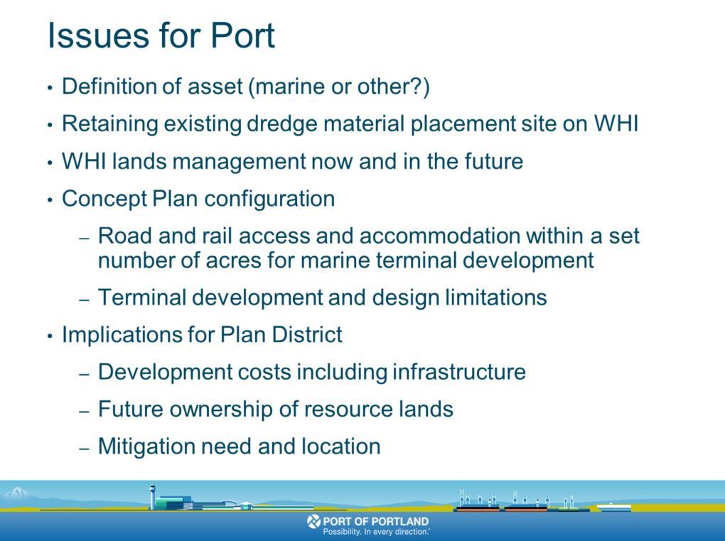
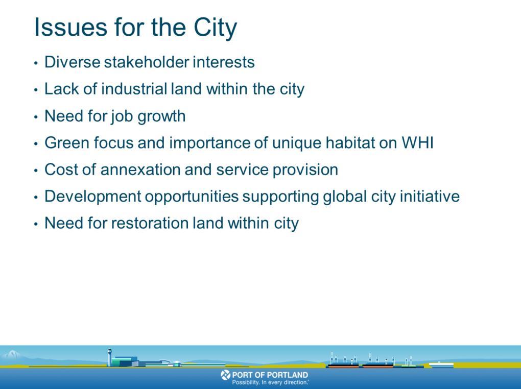
9 We did not have a customer so we knew this would be a BROAD based planning effort, it would lack the specificity that might be seen in some other plan districts where a specific economic opportunity might drive the process and schedule. We truly didn t know if this would be an auto, container or bulk terminal, or some other marine industrial use. The plan district would be based on Diverse stakeholder interests Lack of industrial land within the city Need for job growth Green focus and importance of unique habitat on WHI Cost of annexation and service provision Transportation access Development opportunities supporting global city initiative Need for restoration land within city Reflects technical work, stakeholder and public interests and defines general areas and acreage for future development, recreation and natural 8
10 resource enhancement. Define zoning, use limitations and triggers for development 8
11 9
12 10

13 Part way through the process, in , the City and Port committed to split development and protection on the site between 300 acres of development and 500 acres of natural resource lands. This mid-point understanding had an impact on everything that followed, especially concept planning and the final plan district proposal in With that overview of the planning effort I want to revisit the critical elements of the planning process as they relate to: minimizing risk and life cycle costs, project plans, and phasing and stakeholder impacts that are adjusted to improve outcomes. 11

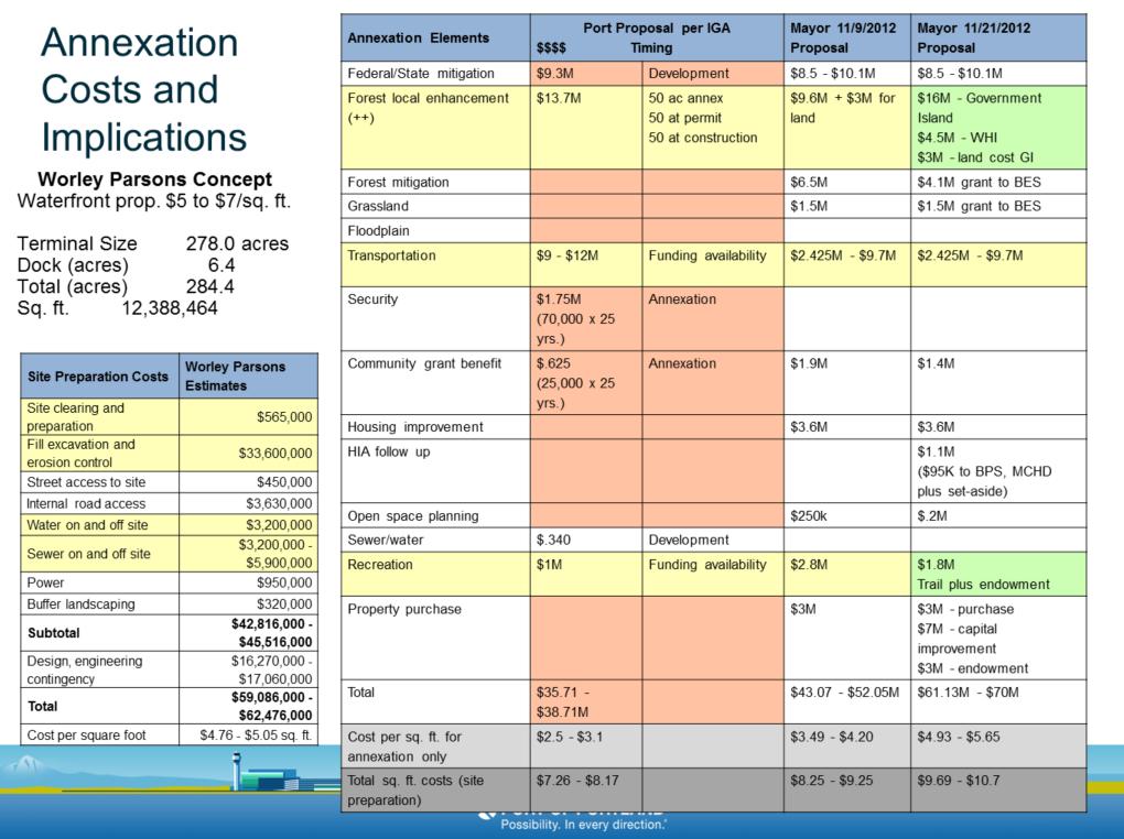
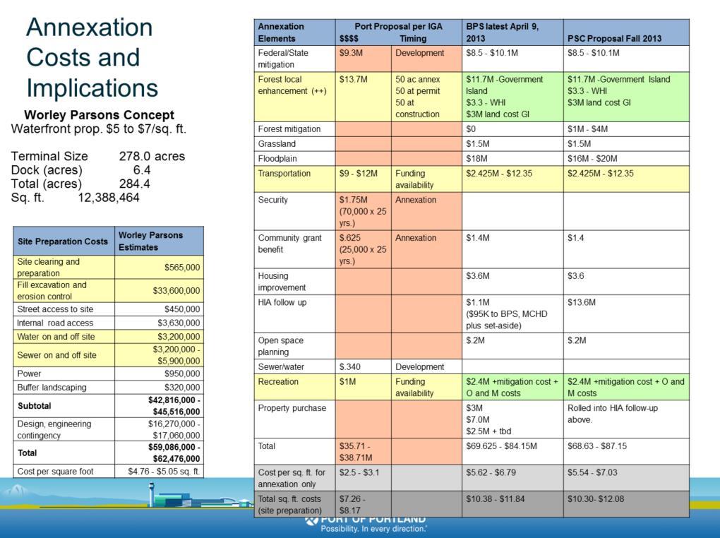
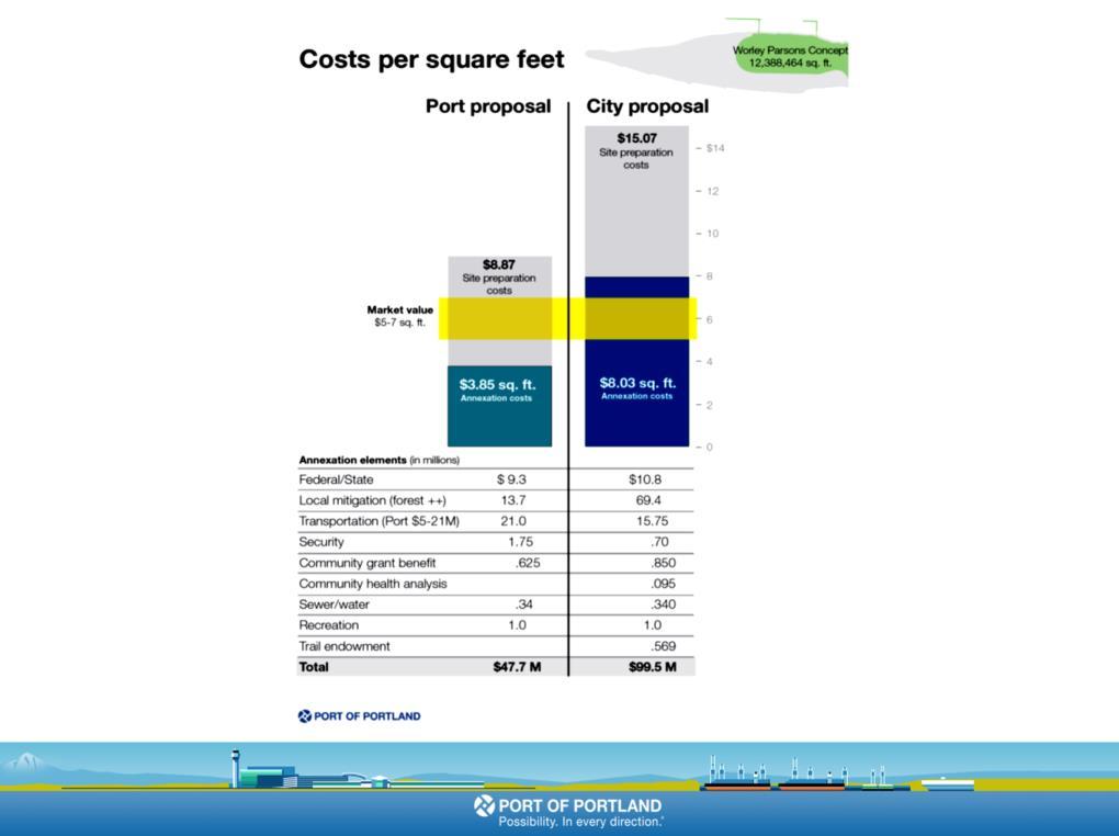
14 A $6 per square foot valuation for shovel ready marine industrial land was at the basis of our feasibility assessment. WHI was and is a long way from shovel ready. As issues like: site preparation - dredging and filling in particular, rail and road access, natural resource mitigation, community impact mitigation and floodplain mitigation were addressed The Port came back to this number over and over again as site conditions, market conditions, and stakeholder concerns were better understood. 12

15 The point of the annexation and plan district process was to allow for future marine terminal development to go forward based on decisions being made today. This is difficult to accomplish and was made more so by the lack of a specific development proposal. Conceptual development plans played a critical role in illustrating land use and zoning that could be accepted by the Port, the city and various stakeholders. We went through a lengthy and detailed concept planning process which I will describe shortly. Entitlements, on the ground guarantees, needed to support financially viable outcomes. 13

16 The Port was simultaneously undergoing a plan district process for the airport, called PDX Futures, while addressing WHI. It became apparent during PDX Futures that defining and committing to a future permitting process would be critical to development and controlling costs and schedule. We were successful in this regard with PDX Futures. Setting up a broadly accepted and well-bounded public review process would also have a positive impact on development feasibility. Addressing mitigation requirements, agreeing to a mitigation program and a mitigation review process was just as important as a development review process. 14

17 Because we did not have tenants we needed to retain some flexibility in site design and use alternatives, for both development and natural resource protection and mitigation. This would be affected by the amount of acreage devoted to the two base zoning types, marine industrial and open space. 15
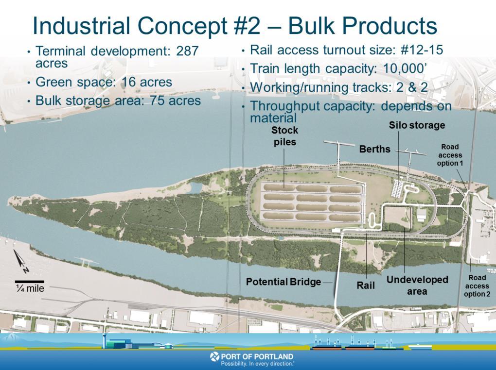
18 To concept planning and feasibility. A reminder of the current state of the island and its location between Portland and Vancouver marine terminals and natural resource lands. The BNSF mainline rail bridge forms the eastern boundary of the site. While the city pursued their own concept planning process with Worley Parsons, the Port undertook a unique effort to do our own concept planning. We hired HDR, ParsonsBrinckerhoff and TransDevelopment to develop concept plans. Each was to design a facility capable of housing 2-3 possible tenants on 300 acres. Each developed versions of a bulk facility, an auto facility and a mixed use facility. The Port then hosted a workshop with all three firms in attendance presenting their proposals to the Port and each other. From the presentations and based on criticism and comments from all those present, including the three consulting firms City staff, and Port staff and management, one concept plan was selected from each firm as the best of its type. Those are shown here. These concept designs were transmitted to the City concept plan team at Worley Parsons to assist in their concept planning process. 16
19 Concept work was based on shared assumptions highlights of which include: City defined boundaries Minimum two terminal configuration Automobile, dry and liquid bulks, or mixed use terminals Rail access, design and operations based on the BNSF Design Guide for Industrial Track Projects Road access and alignment options based on level of use and trip generation rate Rail and road options utilizing existing, planned or potential rights-ofway and infrastructure Vessel berths located to minimize dredging and maximize river channel capacity Dock structures designed to minimize impacts to river and shallow water habitat Maintain a 100 setback from the ordinary high water line 17
20 18

21 The final step in the concept planning process, the step that brings us back to feasibility assessment was conducting a CapEx study using Parson Brinckerhoff s CapEx cost-estimating tool on an HDR developed layout, the BASE LAYOUT, that combined the best attributes of all the concept plans. That BASE LAYOUT looked very much like this mixed use concept. With this information in hand were we better able to assess the financial feasibility of various concepts and most importantly have a solid understanding of site preparation costs. At this point those costs were $ per sq ft. 19

22 The City s concept plan shared some of our site design concepts and included many of the natural resource enhancement and mitigation concepts. 20

23 The Port s ultimate proposal is summarized here, inclusive of mitigation approaches. The port is proposing annexation of WHI into the City of Portland, with appropriate zoning, comp plan, mapping and urban services to provide the opportunity for future marine terminal development. The Port is willing to annex the entire site ( acres) even though City Council has directed only 300 acres to be studied for deep water marine terminal and that is the only portion of the site that requires urban services. In exchange for the annexation of the 300 acres the Port agrees to annex into the city and downzone the remaining 500+ acres restricting development on that portion of the site to a very limited set of open space uses. Will be the first new terminal since the Port purchased the marine facilities from the City of Portland Commission of Public docks in Will ensure Portland a sustainable means to continue participation in the global marketplace Future job growth Direct, Indirect and Induced Estimated at jobs Generating $ Million in personal income Providing $18-30 Million in local and state taxes Local hiring practice will give consideration to residents of Hayden Island and North Portland first. 21
24 The operation will be Rail served and dependent facility Future development permitting would require a completely separate process that considers traffic, noise and other environmental and quality of life concerns Future operation will include state of the art green performance terminal operations including Dark Sky design, zero waste, Leed certified water utilization standards, noise minimization programs, incorporating renewable or alternative energy sources 21

25 At this point, the Port s proposal is above our feasibility goal, the $6 base figure, approaching $8 per square foot. Recall site preparation costs at $4- $5 per square foot. 22
26 23
27 24
28 25

29 F - feasibility M - market A - access Jobs, taxes, economic activity/vitality 26

30 Increasing local mitigation requirements Forest Grassland Flood plain Local discretionary environmental requirements added to state and federal Wetland Shallow water New requirements created specifically for WHI Health analysis 27
31 28