I-69 OHIO RIVER CROSSING HISTORY AND HYDRAULIC UPDATE
|
|
|
- Evangeline Kelley
- 5 years ago
- Views:
Transcription

1 I-69 OHIO RIVER CROSSING HISTORY AND HYDRAULIC UPDATE MARSHALL CARRIER, KYTC, PROJECT MANAGER
2 PROJECT OVERVIEW 2

3 I-69 ORX: A Missing Link Will connect Evansville, IN and Henderson, KY I-69 ORX is one of the last segments needed to complete I-69 in Indiana and Kentucky Both states have made major investments in the I-69 corridor Recent improvements extend from Mayfield, KY to Martinsville, IN 3

4 Project History 2001 Notice of Intent 2004 Draft Environmental Impact Statement (DEIS) Conducted early in KY and IN s plans to expand I-69 Purpose and Need National I-69 Section of Independent Utility #4 Sufficient cross-river mobility in region Strengthen the regional transportation network 4

5 2004 DEIS Key Issues Angel Mounds (visual and noise) Residential/business relocations Traffic performance Floodplains Funding Preferred alternative was not financially feasible With no funding, the project stalled with no Record of Decision 5

6 Purpose and Need Complete the I-69 connection between Indiana and Kentucky Develop a solution to address long-term cross-river mobility Provide a cross-river connection to reduce congestion and delay Improve safety for cross-river traffic 6

7 Project Timeline Spring 2017 Work started in earnest Five broad corridors identified Summer 2017 Short list of corridors identified January 2018 Preliminary alternatives developed Fall 2018 Preferred alternative to be identified DEIS published Fall 2019 Final Environmental Impact Statement and Record of Decision expected 7

8 Stay Informed Website Facebook I-69 Ohio River Crossing 8
9 ALTERNATIVES DEVELOPMENT 9
 East Corridor")
10 Broad Corridors (presented April 2017) No Build Alternative West Corridor 1 West Corridor 2 Central Corridor 1 Central Corridor 2 (2004 DEIS Preferred Alternative) East Corridor 10

11 Screening Approach Develop screening criteria Conduct windshield surveys Collect additional data Evaluate Corridors Does it meet the Purpose and Need? What are impacts to homes, businesses and the natural environment? Can we build it and, if so, how much might it cost? 11
12 Alternatives Development and Supplemental Screening Identify and evaluate interchanges (access, traffic performance, safety) Minimize or avoid impacts to sensitive resources Consider US 41 corridor accessibility and visibility Adjust cost estimates to year of expenditure Estimate life-cycle maintenance costs for I-69 and US 41 bridges Use traffic models to evaluate bridge and toll scenarios 12

13 Preliminary Alternatives January 2018 West Alternative 1: 4-lane I-69 bridge and one US 41 bridge for local traffic West Alternative 2: 6-lane I-69 bridge with both US 41 bridges removed from service Central Alternative 1: 4-lane I-69 bridge and one US 41 bridge for local traffic No Build Alternative: Required to serve as baseline for comparison Other alternatives could be considered based on further analysis Pending updated graphic 13
14 Updated Cost Estimates May 2018 No Build West Alternative 1 West Alternative 2 Central Alternative 1 Design, approvals, right of way, mitigation, procurement, construction inspection $17 M $312 M $352 M $200 M Construction cost (roadway, bridge, toll system, utilities) Construction (2017$) $0 $879 M $874 M $807 M Construction inflation $0 $367 M $347 M $255 M Subtotal - construction $0 $1,245 M $1,221 M $1,062 M Roadway and bridge operations and maintenance (35 years) $270 M $252 M $107 M $234 M Total $287 million $1.81 billion $1.68 billion $1.497 billion 14
15 Paying for I-69 ORX 15 Requires multiple funding sources: Traditional federal and state funding Toll revenues More than 80% cross-river traffic today is local, forecasted to be 65% in 2045 NEPA must consider consequences and mitigation for possible tolling policies No scenarios pay for 100% of the project What we know today: I-69 will be tolled With W1 and C1, tolling US 41 may be necessary Ohio River Crossings and Regional Through Traffic 41,000 AADT 10% Trucks 20% 80% Local traffic 50,000 55,000 AADT 20% Trucks 35% 65% Through traffic Final toll policies determined outside of NEPA, with funding plan before construction
16 ENVIRONMENTAL IMPACTS 16

17 Environmental Impacts Socioeconomic impacts vs. natural environment impacts Dramatic differences between West Alternative 1/West Alternative 2 and Central Alternative 1 West 1 and West 2 follow or are adjacent to US 41, a highlydeveloped main thoroughfare Central 1 is largely green space and farmland 17

18 Natural Environment West 1 and West 2 Fewest impacts to rivers/streams, floodplains, prime and active farmland Low impacts to forested habitat Central 1 Highest impact to forested wetlands and forested habitat Highest impact to active farmland 18
19 Relocation Estimates May 2018 West Alternative 1 West Alternative Residences 27 Businesses 96 Residences 64 Businesses Central Alternative 1 4 Residences 0 Businesses February 2018 Estimates Residences Businesses West Alternative West Alternative Central Alternative

20 Interagency Cooperation Coordination with federal, state and local agencies Multi-jurisdictional coordination Interagency Advisory Committee Regular meetings and field tour Includes formal consultation with US Fish & Wildlife for early discussion of approach to survey work, mussels and bats 20

21 Green River National Wildlife Refuge Long-proposed wildlife refuge along the Ohio River in Henderson Halted for years by lack of funds for land acquisition Approximately 24,000 acres Supporters believe I-69 ORX could mean new life for proposed refuge Opportunity for creative, project-area mitigation options 21
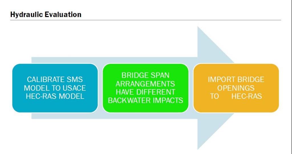
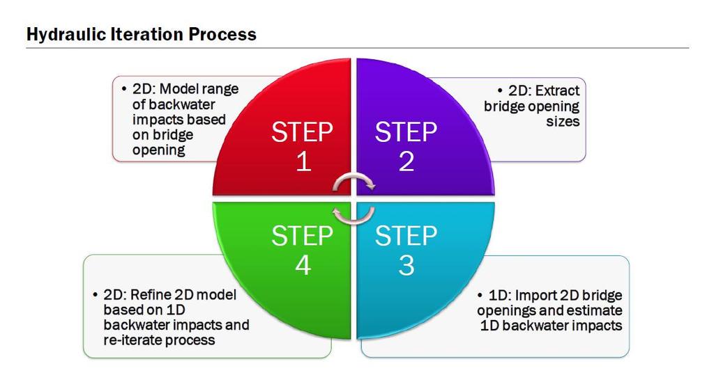
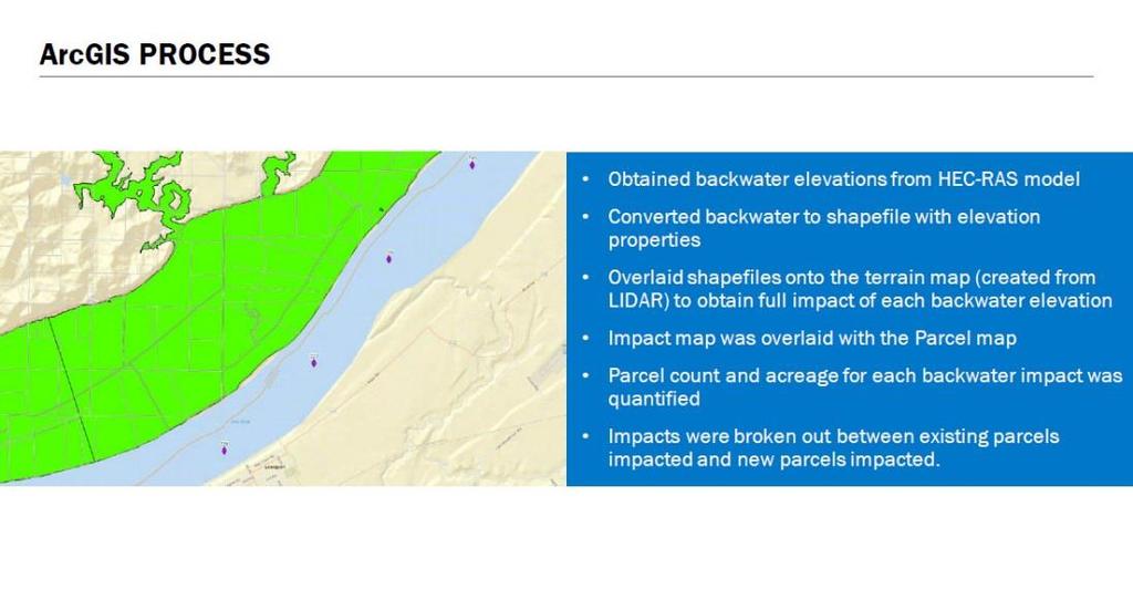
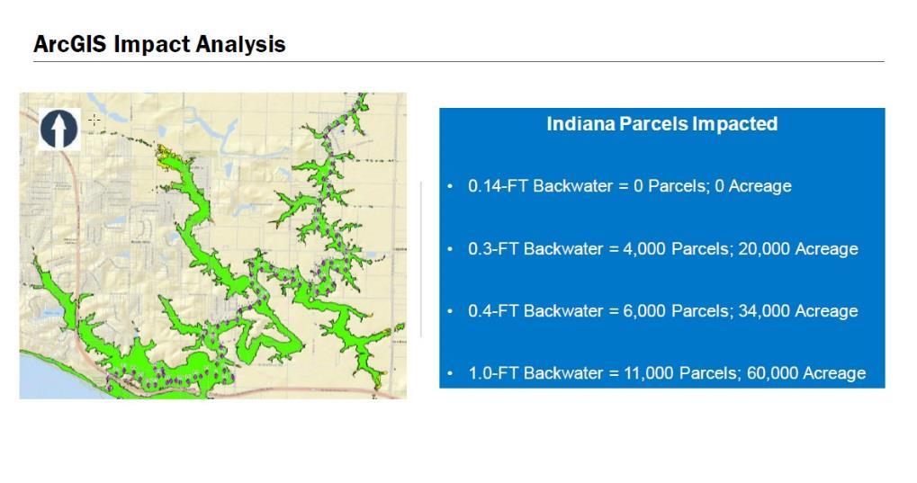
22 22 HYDRAULIC UPDATE
23 23
24 24
25 25
26 26
27 27
28 28
29 29
30 30

31 THANK YOU