Ellerton. Ellerton. Non Technical Summary
|
|
|
- Britney O’Neal’
- 5 years ago
- Views:
Transcription
1 Ellerton

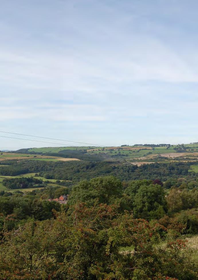
2 View over Ellerton looking south 1. INTRODUCTION Ellerton Quarry is an active sand and gravel quarry that has operated for 15 years. Planning permission was granted in 1994 for the extraction of sand and gravel and under the current permission extraction can continue until 2030 with restoration being completed by The Environment Act 1995 requires that existing mineral permissions are subject to a periodic review every 15 years. North Yorkshire County Council as the Minerals Planning Authority gave notice in June 2009 that the mineral permissions at Ellerton are subject to periodic review. An Environmental Statement has been prepared to assess the potential impacts associated with the working of phases 7-10 over the next 15 years. The sand and gravel reserve is already included in the landbank of reserves allocated to supply North Yorkshire s future needs for aggregate. 2. SITE DESCRIPTION 2.1 SITE LOCATION Ellerton Quarry is located on the north bank of the River Swale approximately 1km east of Catterick at grid reference SE The site lies 11km south east of Northallerton and 17km south of Darlington. It is an operational sand and gravel site, with progressive restoration of worked areas. The total site area is 97ha and working has been arranged in ten phases, six of which have been worked and the seventh is active. Prior to further extraction the soils would be stripped and used in restoration of exhausted phases or temporarily stored for future restoration. Access to the site is from the B6571 which lies on the northern boundary of the site and this would continue to be used.

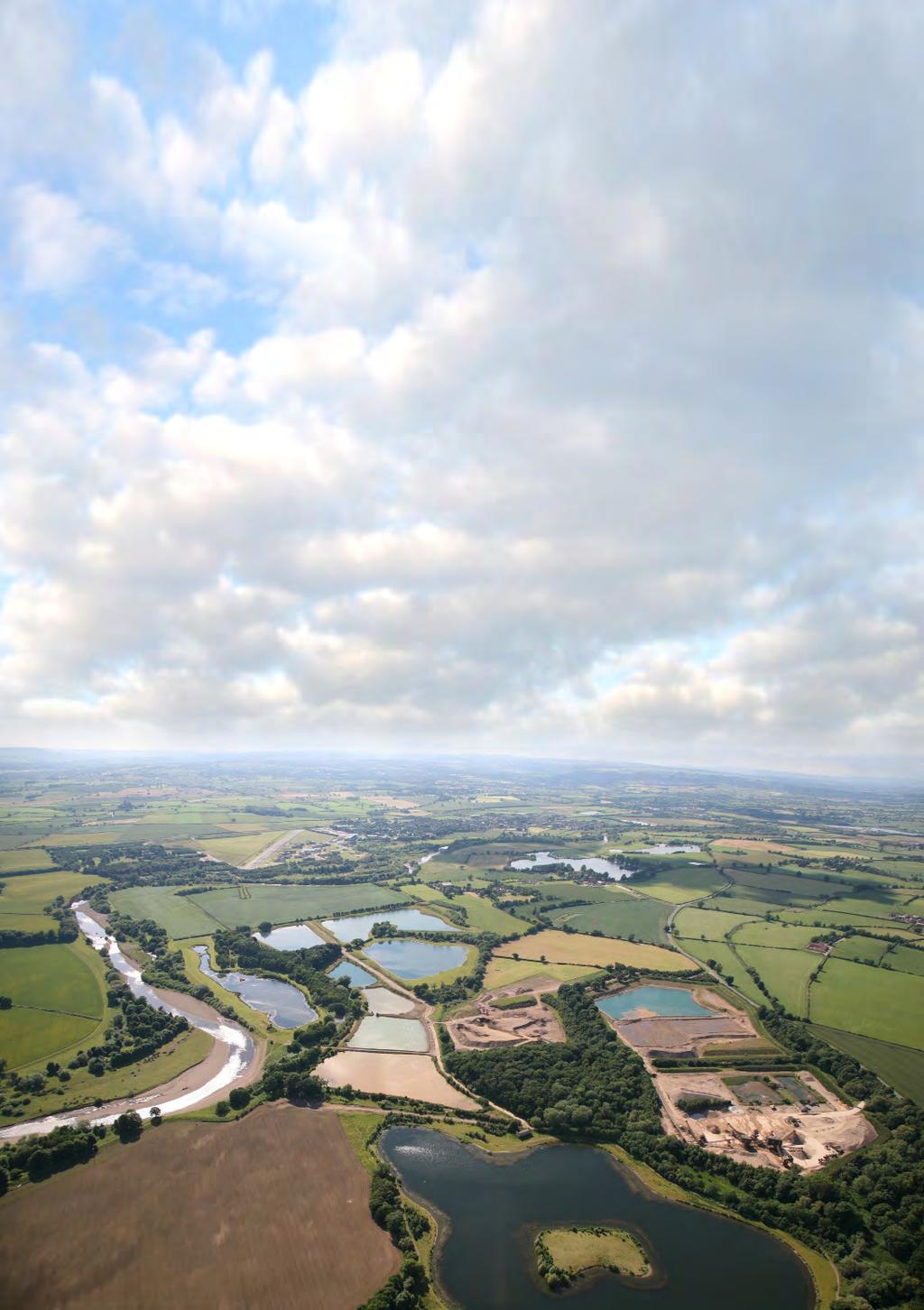
3 2.2 Topography and drainage Ellerton Quarry is on the floodplain of the River Swale, which flows in a generally southeasterly direction, and forms the west and south boundaries of the site. The site itself is almost flat with a very slight gradient towards the river. 2.3 GEOLOGY Ellerton quarry consists of shallow river terraces comprising undifferentiated fluvial sand and gravel deposits which were laid down during a phase between ice ages approximately 15,000 16,000 BP (before present). The sand and gravel deposits are variable with medium to coarse grained sand, coarse gravel and cobbles or finer sands with a finer gravel content. Both have interbedded clay and silt horizons. The sediments originate from uplands to the west and are comprised of Carboniferous sandstones and limestone. The sands and gravels are underlain by glacial clays which in turn lie on a Permo-Triassic bedrock of sandstones and limestones. Ellerton Restored lakes in phases 2 to 6 3. PROJECT DESCRIPTION 3.1 Hours of operation Mineral extraction working hours Monday Friday hours Saturday hours Sundays and public holidays No working

.")
4 3.2 Mineral extraction scheme design The site is being worked in ten phases, six of which have been completed and are being progressively restored. Phase 7 is an active phase and phases 8, 9 and 10 have yet to be worked. Sand and gravel extracted from the site is currently transported by conveyor to the neighbouring Kiplin Hall Quarry for processing, however, this arrangement is expected to cease in the near future when Kiplin Hall closes and thereafter processing would take place at Ellerton in accordance with the original permission Phase 7 ( ). This is the active phase with extraction in progress on the west side. Extraction will continue southwards in an anti-clockwise direction. Some of the topsoils, overburden and clay layers within the sands and gravels would be used to complete the restoration of the central lake (created in Phase 5). The remaining clays would used as a barrier along the western side as extraction progresses to minimise water ingress when dewatering is undertaken. Phase 8 (2015) Excavation would commence on the western side and progress in an anti clockwise direction with excavated clays being used as a barrier along the western boundary to minimise water ingress during dewatering. The clays arising from Phase 8 would be used to divide the proposed north-west and south-west lakes. Once completed, the north-west lake would be partially flooded to within 1.0 metre of final water level. Phase 9 ( ) After striping soils the extraction would follow the same anticlockwise working method as the previous phases starting in the west. Stored topsoils would be used to complete the restoration of the lake margins. Phase 10 ( ) As in the previous phase, extraction will commence in the west and excavated clays will be used as a barrier along the west and southern boundaries. The remaining soils and clays would be used in the restoration of the south-west lake. Phases of working

5 Concept Restoration 3.3 restoration scheme The fully restored site will create a series of lakes and wetland areas within a framework of causeways, determined principally by the retention of existing site features. The proposals include two fishing lakes; one board sailing lake; one dingy sailing lake; a riverside lake and a series of reed beds separated by a belt of alder/ willow carr. The processing plant and stockpile areas on the northern side of the site will be returned to agricultural use with field boundaries created by new hedgerows. Two lakes suitable for fishing are located in the north-eastern section of the site created from phases 3 and 5 of the extraction. They are profiled with irregular shorelines with gradient variations to maximise the variety of aquatic and marginal habitats. The shallower part of the shore profiles and submerged gradients are soiled to a depth of 300mm to promote the establishment of the micro flora and fauna which form the base of the fish food chain. Two larger lakes in the western section of the site and will be created from phases 7 to 10 of the extraction. These will be developed for sailing. The nature reserve has been developed in the south-eastern section of the site created from the extraction of phases 1, 2, 4 and 6. and includes a riverside lake, reed beds and woodland. The reed beds are being created from the silt lagoons planted with reeds, rushes and reedmace. The riverside lake includes some shorelines surfaced with cobbles and shingle to provide continuity with the nearby river bank habitats. The existing woodland will be supplemented with additional alder and willow carr wet woodland planting within the nature reserve area.

6 4. LANDSCAPE AND VISUAL IMPACT The continuing extraction and restoration of the site will not significantly alter the landscape character of the area as it is a well established use. There will be slight adverse effects on the landscape character during operations, which will be offset by positive intervention including progressive restoration and the retention of surrounding woodland. After restoration the character of the site landscape will be improved. View of proposed extraction area 5. CULTURAL HERITAGE Following a thorough study of the area yet to be worked including desk-based research and a walkover survey, the potential for archaeological remains to exist within this area at Ellerton Quarry is considered low to medium. No archaeological remains are currently known within the proposed development area. This view is based on a informed professional judgement of the known archaeological and historic features immediately around the site and in the wider 3km radius study area, together with knowledge of the likelihood of typical archaeological associations with the types of landforms that comprise the extraction area. However, given the shifting course of the River Swale across the southern and western parts of the study area, archaeological deposits there are likely to have been eroded by river action or covered by the deposition of alluvial deposits. It is proposed that a watching brief on is implemented during operation of the unworked phases and land below the soil bunds. This work will be done far enough in advance of extraction to allow a full record of any archaeological features in this area to be made. The development will not affect the setting of any of the surrounding cultural heritage sites. 6. SOILS & AGRICULTURE The extraction of sand and gravel from the remaining undisturbed land at Ellerton, followed by restoration to areas of nature conservation interest, will result in the permanent loss of approximately 20 ha of low quality agricultural land. At present, land on the periphery of the site is used for storage of previously stripped soils and these soils would be used in the restoration of the site. All soil resources will be used in site restoration.

7 View over the phase 7 area 7. WATER RESOURCES The surface and groundwater in the vicinity of Ellerton have been investigated and potential impacts associated with mineral extraction have been considered. A substantial proportion of the sand and gravel is situated beneath the watertable. Therefore, all future phases of extraction will require dewatering in order to allow dry working of the mineral. The highest dewatering rates being required during Phases 7 and 8. Water generated from dewatering will be directed through the existing silt lagoons before being discharged via the consented discharge point. This will prevent any silt entering the watercourse. No long-term significant impacts to groundwater flow and direction are predicted after the restoration of the quarry. There are concentrations of metals from past mining activities upstream found in the floodplain sediments of the River Swale. Samples collected on site have been laboratory tested and indicate that soils can be used in the restoration of the site, because the lead, zinc and cadmium are not in soluble form. Mitigation measures include: The water used within the plant for washing sand and gravel would be pumped to settlement lagoons to prevent any silt entering waterways. Tarmac s environmental management system would ensure there is no contamination from fuel and oil. All long term soil storage mounds would be grass seeded to prevent leaching of nutrients and silt from entering waterways. A flood risk assessment indicates that there is adequate storm water storage within the lagoons during the operational and restoration phases. On completion of the restoration, the area of open water will increase, which would provide further flood storage on site.
8 8. AIR QUALITY Air quality could potentially be affected by dust arising from soil stripping and storage, site haulage, mineral processing, backfilling and site restoration. However, since the sand and gravel would be extracted when still wet no dust would arise from this operation. Notwithstanding this the vast majority of any dust emissions from the Ellerton site would be large particles that do not move travel than 100m from the site. No residential properties have been identified within this distance of the site; the closest is Manor House 115m to the north of the Phase 7 boundary. In order to ensure there is no nuisance caused in the local area, mitigation measures are implemented on site. With these in place, any dust generated would be controlled at source. Such measures include: Damping of haul roads Vehicle speeds restricted to 10mph/hr Minimising drop heights when loading vehicles Wheel washing facilities Sheeting of vehicles 9. NOISE The site is in a relatively quiet rural location. The closest residences that could be affected by noise are Manor House, 115m north of the Phase 7 boundary, and Killerby Hall 500m to the south of the Phase 10 boundary. Minerals Policy Statement 2 (MPS2), Controlling and Mitigating the Environmental Effects of Minerals Extraction in England provides noise level limits that can be set to ensure noise is controlled within acceptable levels. Predicted noise levels have been calculated for the long-term operations of mineral extraction and short-term operations such as soil stripping. This has shown that noise levels can conform to the noise criteria provided by MPS2. Noise control measures include: The use of temporary soil storage mounds to act as acoustic barriers. The stand-off distances between the sensitive residential receptors and the processing plant. Noise-monitoring will be carried out in accordance with a documented programme and remedial measures enforced if required. Any noise complaints will be recorded and investigated, in accordance with the site environmental management plan, which includes the requirement of liaison with relevant officers from the District Council.
, supporting a range of fauna, including a diverse bat population.")
9 10. flora AND FAUNA Much of the site value is a result of extraction and restoration completed to date and which has resulted in the creation of a variety of wetland habitats within a matrix of woodland and scrub habitats, adjacent to the River Swale. The River Swale is a Site of Nature Conservation Interest (SNCI), supporting a range of fauna, including a diverse bat population. The future extraction areas, however, primarily comprise arable land of little ecological value. Ellerton The quarry s breeding bird population includes species linked to Swale Lakes SSSI and species of national conservation concern. During the winter months the quarry provides habitat for species that are of national conservation concern such as Golden Plover, Green Sandpiper and Lapwing and notable concentrations of a number of other species, particularly waterfowl. Appropriate working methods will be implemented to ensure that all wetland habitats both within the site and the river corridor adjacent are protected, ensuring no degradation of the adjacent river local wildlife site or the various wetlands present within the site. With appropriate mitigation including undertaking checking surveys, implementing precautionary working methods, the risk of harming or disturbing protected species during works will be minimised. Restoration works and the provision of features such as bat boxes, will ensure the long term conservation status of these key species. Priority within the restoration will be given to the use of native species and wherever possible the creation of habitats of value to those protected species present and those included in Tarmac s Biodiversity Action Plan for Ellerton. The restored site will enhance the range of wetland habitats in the River Swale corridor. A Lapwing
10 11. TRANSPORT At present sand and gravel extracted at Ellerton is transported by field conveyor to the adjacent Kiplin Hall Quarry for processing and distribution. This arrangement is due to cease in the near future, at which time processing will revert to Ellerton. When this happens the total number of heavy goods vehicle movements from Ellerton (HGVs) would be an average of 25 vehicles in and 25 out per day. In 2016 production will cease at Scorton Quarry and production and the accompanying vehicle movements will shift to Ellerton. HGV movements from Ellerton would increase to 125 vehicles in and 125 vehicles out per day. Under the present planning permission there is no restriction on vehicle movements from Ellerton. Overall there will be no net increase in numbers of vehicles carrying sand and gravel from Tarmac sites. A Transport Assessment has analysed existing traffic flows and highway accident records, and considered the effects of traffic flows. The findings of the study were that that: The continued working of the quarry would not produce any additional HGV traffic from that which is currently in operation by Tarmac. Analysis of the routes and main junctions demonstrate that they all operate well under capacity with the current level of quarry based HGVs and other traffic flow. North Yorkshire County Council (NYCC) has confirmed that there are no reported problems with HGV accidents on the local road network. The wheel wash and the fully surfaced access road will prevent any mud tracking onto the road and thus alleviate the risk of road accidents. 12. ACCESS AND RECREATION The impacts of the development on recreation amenity and public rights of way have been assessed. There are no public rights of way within the site. Pedestrian access to the nature reserve would be restricted to key holders. The proposed use of the lakes for fishing and sailing would be subject to further permission. Access would be controlled and informal parking bays provided along the access tracks together with an area between the sailing lakes for boats. 13. CONCLUSION The potential environmental effects of the proposed mineral extraction operation has been assessed in the Environmental Statement. Overall it can be concluded that the proposed development will increase the landscape and visual qualities of the area while also providing ecologically diverse, species rich habitats. The local environment can be protected throughout operations and the amenity of local residents will not be adversely affected. The existing markets for sand and gravel can continue to be supplied.