DEPARTMENT OF THE ARMY JACKSONVILLE DISTRICT CORPS OF ENGINEERS P. O. BOX 4970 JACKSONVILLE, FLORIDA PUBLIC NOTICE
|
|
|
- Ferdinand Willis
- 5 years ago
- Views:
Transcription
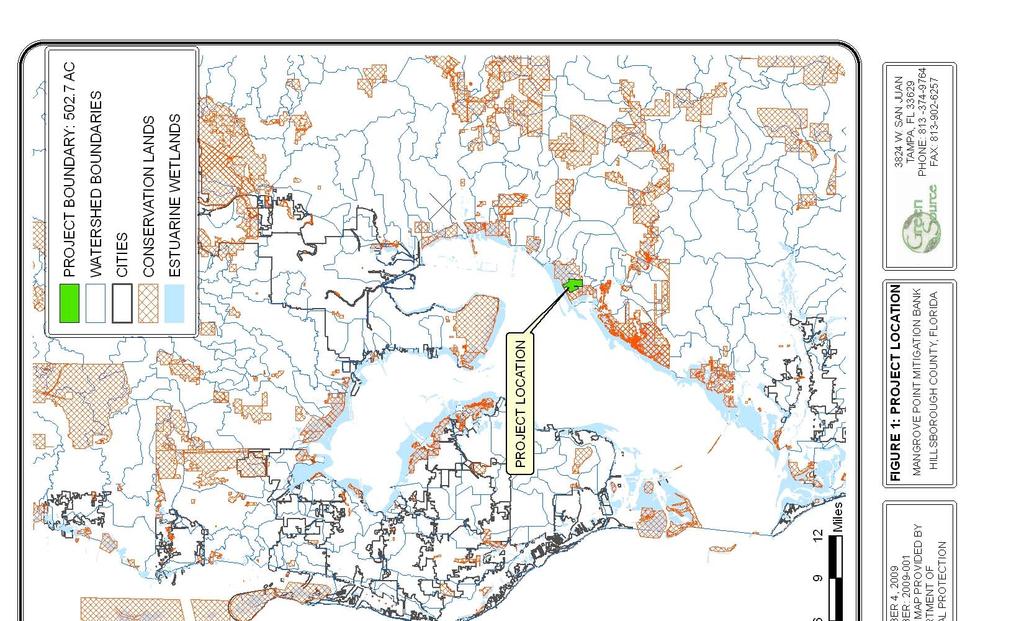
1 DEPARTMENT OF THE ARMY JACKSONVILLE DISTRICT CORPS OF ENGINEERS P. O. BOX 4970 JACKSONVILLE, FLORIDA REPLY TO ATTENTION OF Regulatory Division Special Projects and Enforcement Branch Jacksonville Regulatory Office March 2, 2010 PUBLIC NOTICE Permit Application No. SAJ CLB TO WHOM IT MAY CONCERN: This District has received an application for a Department of the Army permit pursuant to Section 404 of the Clean Water Act (33 U.S.C. 1344) as described below. APPLICANT: Mangrove Point Mitigation Bank, LLC 888 SE Third Avenue, Suite 501 Fort Lauderdale, FL WATERWAY & LOCATION: The proposed project, referred to as Mangrove Point Mitigation Bank (MPMB), is approximately 503 acres and drains west into Tampa Bay. MPMB is located west of Ruskin, north of 19 th Avenue and west of US 41 in southern Hillsborough County, Florida. The project is specifically located in Sections 25, 35, and 36, Township 31 South, Range 18 East (see attached Location Map). DIRECTIONS: From Tampa, take US 41 south, make a left heading west on 19th Avenue, and the project site is on the right-hand side before E.G. Simmons Park. LATITUDE & LONGITUDE: (center of site) Latitude Longitude PROJECT PURPOSE: BASIC: To create a wetland mitigation bank that could be used to provide compensatory mitigation required for authorized project impacts to waters of the United States. OVERALL: The restoration/enhancement of aquatic resources based on a watershed approach that would provide off-site compensatory mitigation for federal jurisdictional aquatic resource impacts within an appropriate service area.
2 -2- PROPOSED WORK: OBJECTIVES OF THE PROPOSED BANK: The objective of the MPMB is to provide appropriate compensatory mitigation for authorized saltwater (estuarine/marine) wetland impacts within the Tampa Bay watershed. The MPMB would increase wetland function within the watershed by restoring, enhancing, creating, preserving, and managing in perpetuity significant amounts of ecologically valuable and regionally significant wetland habitat that contain endangered and threatened wildlife, plants, habitats, and other natural resources located within Tampa Bay. The applicant proposes to fill approximately 6.7 acres of waters of the United States (wetlands). The fill would be in mosquito ditches on site (see attached map.) A functional analysis has not yet been finalized on the proposed MPMB by the Federal IRT. The Uniform Mitigation Assessment Method (UMAM) would be used to quantify the wetland functions and values and determine the number of potential wetland mitigation credits (ecological lift) the proposed mitigation bank could possibly generate. The analysis would include applying a Risk Factor and a Temporal Lag Factor (a correction factor of time) to appropriate assessment areas. Credits are proposed to be released through a combination of specific tasks or programs and meeting specific performance-based success criteria. The amount of credits available in the MPMB would be the product of the multiplier (based on tasks completed or success criteria met) and the acreage of each mitigation category type. No credits are derived from upland assessment areas (non-wetlands), which are excluded from Federal UMAM calculations. The MPMB proposed credit yield is saltwater credits. If it is determined that the issuance of a permit for the proposed MPMB is appropriate, and credits are approved and released by the Corps, the MPMB would be permitted to withdraw and sell those credits. These credits would be used to offset wetland impacts from private and public sector clients, for the purpose of providing required compensatory mitigation for their project(s). These credits could only be used if the Corps has determined the use of MPMB to be appropriate and the proposed impact site is located within the approved geographic service area of the MPMB. The credits necessary to offset specific wetland impacts would be based upon the type and quality of wetlands being impacted by the project(s) and would require approval by the Corps. The official credit ledger would be
3 -3- maintained by the Corps. Each Corps permit application that proposes to use the MPMB would contain an up-to-date account of the credits available, credits used, and the number of credits proposed to offset the project impacts. With the issuance of a Department of the Army Permit, authorizing wetland fill or impacts and the use of the MPMB for mitigation credits, the Corps would verify all changes to the credit balance. BANK ESTABLISHMENT AND OPERATION: The proposed work for the MPMB consists of multiple mitigation methods intended to create, restore, enhance, and preserve in perpetuity wetland functions as similar as possible to the historical conditions prior to anthropomorphic disturbances while considering existing logistical constraints. The applicant proposes the following activities to generate credits: Backfilling of ditches/removal of spoil piles Removal of berms/access roads Creation of meandering tidal creeks Removal of trash Fencing and signage to prohibit unauthorized access Elimination of nuisance and/or exotic plant species Management of nuisance wildlife species (feral hogs) Installation of native herbaceous, shrub, and tree species Implementation of an objective-based Adaptive Habitat Management Plan, including adaptive monitoring Placement of a conservation easement Funding provided for short-term restoration activities Funding provided for long-term management activities Cooperation of a long-term management steward The target community types for the MPMB are designed to help fulfill restoration targets set by the Tampa Bay Estuary Program, for the Tampa Bay watershed. Currently there are deficits of 1,205 acres of salt marsh, 544 acres of saltern, and 1,813 acres of seagrass habitats. These rare habitats are in need of expansion through creation, restoration, and enhancement, and protection through preservation; the establishment of the MPMB will assist in the increase of these rare habitats. The target community types for the MPMB will include seagrass, mud flats, mangrove, saltern, small ponds, and oligohaline marsh.
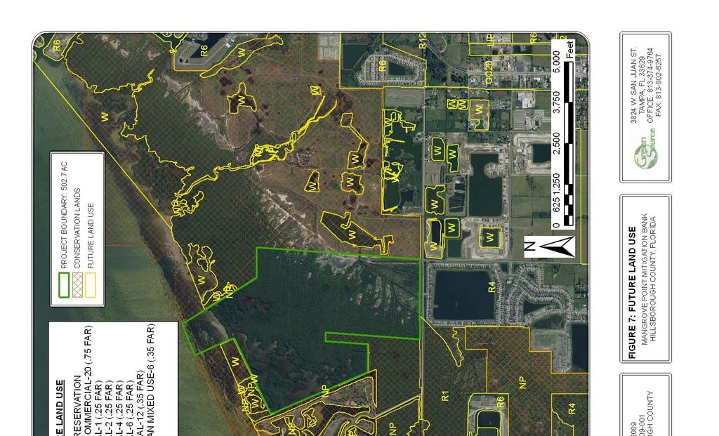
4 -4- PROPOSED SERVICE AREA: The Mitigation Service Area (MSA) for the MPMB is proposed to be the entire estuarine component of the Tampa Bay watershed and the tidally influenced reaches of the rivers emptying into Tampa Bay (Basin Number 13) (see attached Proposed Service Area Map). These rivers include the Hillsborough, Alafia, Manatee, and Little Manatee. Anticipated customers of the MPMB include private developers and government agencies required to offset unavoidable impacts to wetlands. THE NEED FOR AND TECHNICAL FEASIBILITY OF THE BANK: Establishment of the MPMB will contribute significantly to many ongoing regional conservation efforts. All of the project parcels are located adjacent to existing conservation lands managed by Hillsborough County Parks, Recreation, and Conservation Department. The MPMB will contribute to the expansion and effective management of these conservation lands, as well as protect these existing conservation areas from the detrimental effects of continued development. Specific regional conservation efforts that will benefit from the establishment of the MPMB include the preeminent regional conservation effort, the Tampa Bay Estuary Program Comprehensive Conservation and Management Plan, Charting the Course. The natural hydrologic regime of the MPMB has been significantly altered by extensive mosquito ditching and adjacent spoil pile deposition. These actions have resulted in significantly degraded wetland function, particularly decreased water quality, onsite, upslope, and downslope. Within the historical extent of the saltern habitat, ditches will be completely backfilled by the adjacent spoil piles to return to natural grade, restoring the MPMB habitats to a more natural hydrologic regime. This restoration method has been utilized in several other projects of similar scope, including the Weedon Island restoration project, the Alligator Point restoration project, and most notably, the adjacent Wolf Branch Park restoration project. The large mosquito ditch fragmenting the saltern on Wolf Branch Park contiguous with the MPMB to the east was backfilled to return the saltern to natural grade, restoring the area of the ditch and spoil piles and enhancing the adjacent slattern by returning the natural hydrologic regime. A baseline evaluation of the nekton communities within the mosquito ditches will be conducted to ascertain where the mosquito ditches no longer provide suitable habitat. A large berm in the southeastern corner of the site that obstructs natural flow will be removed by replacing the spoil into the
5 -5- borrow pit. Wolf Branch Park restoration deposited spoil into this pit. The entire area will be re-graded to natural topography to reestablish the natural hydrologic regime. Meandering tidal creeks have been demonstrated to be instrumental in achieving success of mangrove restoration. They slow water flowing into the estuary, allowing absorption of nutrients, sediment settling, and water temperature equilibrium. They also provide habitat for fish communities. Upon restoration, a meandering tidal creek will be created to reroute water through two ponds in order to facilitate tidal flushing. Trash and construction debris on the site can contaminate surface and ground water and threaten wildlife utilization. All trash will be removed and contaminants, if present, will be remediated. Fencing will be constructed at appropriate locations to prohibit unauthorized access. Nuisance and/or exotic species removal will be conducted to address historical disturbances and unavoidable edge effects from adjacent land uses. A combination of manual, mechanical, and chemical treatments will be utilized as appropriate. Management of feral hogs will be conducted where it is determined that there is sufficient damage to warrant control. Many of the community types that have been altered would not be able to recover without restoration of natural hydrologic regime and elimination of exclusionary exotic species. Once these adverse impacts have been rectified, native species will be replanted to restore the natural community type if natural recruitment does not occur. Historical aerial photography, adjacent community structure and composition, and relic examples of native community types will be utilized to determine the most natural community structure and composition. Herbaceous, shrub, and tree species will be planted accordingly, based on the appropriate hydrological and topographic conditions. An objective-based Adaptive Habitat Management Plan (AHMP) will be developed and utilized to inform management decisions for the project site. This will include components for vegetation and wildlife management, and monitoring protocols for water, vegetation, and wildlife. OWNERSHIP ARRANGEMENTS AND LONG-TERM MANANGEMENT STRATEGIES: The MPMB will be protected in perpetuity with a conservation easement (CE) placed over the entire site and dedicated to a long-term management steward. It is anticipated that the CE will be dedicated to the Hillsborough County Parks and Recreation Department (HCPRD) because they are responsible for management of
6 -6- the adjacent E.G. Simmons Park and Wolf Branch Park. Surety will be provided for short-term management activities. A non-wasting escrow fund will be established to finance long-term management activities. The specific mechanisms for the financial assurances will be developed in coordination with the IRT. A portion of each credit sale will be deposited into the escrow fund for the longterm management activities. The amount of the deposit will be determined during the consultation with the IRT, once long-term management costs have been agreed upon. The escrow fund for the project will be available for use by the long-term management steward upon disposal of the MPMB. It is anticipated that the long-term management steward will be the grantee of the conservation easement unless otherwise determined. SPONSOR QUALIFICATIONS: The sponsor is utilizing the services of GreenSource biologists experienced in verifying, assessing, maintaining, creating, and restoring aquatic resources. GreenSource is currently working on several other mitigation and conservation banks. They have completed feasibility studies for banks and have permitted several permittee-responsible mitigation projects for residential developers and sand mines. EXISTING SITE CONDITIONS: The MPMB contains a mosaic of estuarine habitats, utilized by a large number of recreationally and commercially important fish, shellfish, and wading bird species. The MPMB contains subtidal seagrass habitats, subtidal and intertidal mangrove with remnants of historical meandering tidal creeks, intermixed with mud flats, saltern, and oligohaline marsh. An extensive series of mosquito ditches and adjacent spoil piles has significantly impacted the intertidal habitats, with the most extensive degradation occurring to the rare and sensitive saltern habitat. Other disturbances to the oligohaline marsh include the excavation of a borrow pit, and an adjacent access road. Historical aerial photography was available for the site beginning in The 1938 aerial has been chosen for this project as the reference condition because that year showed no onsite degradation and the lowest amount of upslope encroachment by agriculture. Currently, the MPMB project contains a large amount of important natural resources, including listed wildlife species, listed plant species, and listed habitats, as well as a variety of other types of significant natural resources, such as priority wetlands, surface waters, and wildlife corridors. THREATENED & ENDANGERED SPECIES: The U.S. Army Corps of Engineers has determined that the proposed project may affect,
7 -7- but is not likely to adversely affect the following federally threatened and endangered species: the eastern indigo snake (Drymarchon corais couperi), the West Indian manatee (Trichechus manatus), and the wood stork (Mycteria americana). Consultation with the U.S. Fish and Wildlife (USFWS) and the National Marine Fisheries Service (NMFS) will be initiated separately by the Corps. The Corps final determination related to any potential impact to threatened and endangered species is subject to review and coordination with the USFWS and NMFS. ESSENTIAL FISH HABITAT (EFH): This notice initiates consultation with the National Marine Fisheries Service on EFH as required by the Magnuson-Stevens Fishery Conservation and Management Act The proposed work would result in a net enhancement of aquatic resources, such as mangrove, seagrass, mud flats, tidal creek, and oligohaline marsh, which may be utilized by various life stages of coastal migratory pelagics, red drum, reef fish, shrimp, and stone crab. However, there may be some temporary disturbance of mangrove habitat during the filling of mosquito ditches. Our initial determination is that the proposed action would not have a substantial adverse impact on EFH. Consultation with the National Marine Fisheries Service will be initiated separately by the Corps. The Corps final determination related to the project impacts is subject to review and coordination with the National Marine Fisheries Service. NOTE: This public notice is being issued based on information furnished by the applicant. Not all of the information has been verified. The proposed project is shown on the attached figures. AUTHORIZATION FROM OTHER AGENCIES: A State Water Quality Certification/Permit is required for this project. The Southwest Florida Water Management District (SWFWMD) or the Florida Department of Environmental Protection (FDEP) will concurrently review this project. Comments regarding the application should be submitted in writing to the District Engineer, as shown on the above letterhead address, within 30 days from the date of this notice. If you have any questions concerning this application, you may contact Carrie L. Bond by letter using the letterhead address, by Carrie.L.Bond@usace.army.mil, by telephone or by fax
8
9

10
11
12
13

14
15
16
17 MANGROVE POINT MITIGATION BANK MITIGATION SERVICE AREA TAMPA BAY BASINS MANGROVE POINT MITIGATION BANK ± DATE: FEBRUARY 4, 2010 PROJECT NUMBER: SOURCE: HILLSBOROUGH CO. GIS DEPARTMENT 0 MITIGATION SERVICE AREA MANGROVE POINT MITIGATION BANK HILLSBOROUGH COUNTY, FLORIDA Miles 3824 W. SAN JUAN ST. TAMPA, FL OFFICE: FAX:
18 Project Boundary ± ,480 2,220 2,960 Feet DATE: JANUARY 20, 2010 PROJECT NUMBER: SOURCE: USGS USGS 7.5' QUADRANGLE MANGROVE POINT MITIGATION BANK HILLSBOROUGH COUNTY, FLORIDA 3824 W. SAN JUAN ST. TAMPA, FL OFFICE: FAX:


19


20
21 Proposed Fill ac PROPOSED FILL LOCATION