Prepared for. Urban Water Management Plan Sonoma County Water Agency. June 2011
|
|
|
- Rose Campbell
- 5 years ago
- Views:
Transcription


1 Prepared for 2010 Urban Water Management Plan Sonoma County Water Agency June 2011


2 2010 Urban Water Management Plan Prepared for Sonoma County Water Agency Santa Rosa, CA June North Civic Drive, Suite 115 Walnut Creek, California 94596
3
4 Table of Contents List of Figures... v List of Tables... v List of Abbreviations... vii 1. Introduction Urban Water Management Planning Act Resources Maximization and Import Minimization Coordination Public Participation and Plan Adoption Plan Organization Assumptions Potter Valley Project Threatened and Endangered Species -- Russian River Biological Opinion Future Water Supply Projects Climate Change Description of Existing Water System Description of Service Area and Climate Surface Water Supply Facilities Lake Pillsbury and the Potter Valley Project (PVP) Lake Mendocino and Coyote Valley Dam Lake Sonoma and Warm Springs Dam Groundwater Facilities Water Transmission System Projected Wholesale System Deliveries Evaluation of Portion of Projected Total Water Demand to be Met by Water Agency Supplies Evaluation of Water Demand Projections by Water Agency s Water Contractors and MMWD Evaluation of Water Demand Projections for Other Water Transmission System Customers and Russian River Customers Employment, Land Use, and Population Employment Characteristics Land Use Characteristics Population Projections Water Use Water Supply Surface Water Physical Constraints iii
5 Sonoma County Water Agency 2010 UWMP Table of Contents Legal Constraints Russian River System Model (RR ResSim) Model Approach Model Study Results Groundwater Description Sonoma County Groundwater Basin Assessment and Management Program Activities Alexander Valley and Sonoma Valley Basins Santa Rosa Plain Subbasin Other Water Agency Groundwater-Related Studies/Programs Groundwater Banking Feasibility Study Flood-Control/Groundwater Recharge Watershed Studies CASGEM Compliance Water Agency s Groundwater Supply Wells Physical Constraints Legal Constraints Transfer and Exchange Opportunities Desalination Recycled Water Coordination and Promotion of Recycled Water Use Wastewater Collection, Treatment, and Disposal Sonoma Valley County Sanitation District Airport-Larkfield-Wikiup Sanitation Zone Recycled Water Use Current and Projected Water Supplies Water Supply Strategies Water Supply Reliability Climate Change Water Quality Impacts on Future Water Supply Water Conservation BMP Implementation Water Supply Versus Demand Comparison Normal Water Supply vs. Demand Comparison Dry Year Water Supply vs. Demand Comparison Multiple Dry Year Water Supply vs. Demand Comparison References... REF-1 Appendix A: UWMP Outreach and Coordination... A Appendix B: Best Management Practices Report Filing... B Appendix C: Water Shortage Contingency Plan... C Appendix D: Urban Water Management Plan Checklist... D iv
6 Sonoma County Water Agency 2010 UWMP Table of Contents List of Figures Figure 2-1. Precipitation Map Figure 2-2. Russian River Watershed Figure 2-3. Water Agency Service Areas and Water Transmission System Facilities Figure 4-1. Groundwater Basins List of Tables Table 1-1. (DWR Table 1) Coordination with Appropriate Agencies Table 2-1. Climate Table 3-1. (DWR Table 2) Population Current and Projected Table 3-2. (DWR Tables 9 and 12) Water Agency Sales to Water Agency Contractors and Customers (ac-ft/yr) Table 3-3. (DWR Table 10) Additional Water Uses and Losses (ac-ft/yr) Table 3-4. (DWR Table 11) Total Water Use (ac-ft/yr) Table 4-1. Future Water Agency Russian River Demands Modeled Table 4-2. Average Year Minimum Lake Mendocino Storage (1962) Table 4-3. Average Year Minimum Lake Sonoma Storage (1962) Table 4-4. Single Dry Year Minimum Lake Mendocino Storage (1977) Table 4-5. Single Dry Year Minimum Lake Sonoma Storage (1977) Table 4-6. Multiple Dry Year Minimum Lake Mendocino Storage ( ) Table 4-7. Multiple Dry Year Minimum Lake Sonoma Storage ( ) Table 4-8. (DWR Table 18) Amount of Groundwater Pumped by the Water Agency (ac-ft/yr) Table 4-9. (DWR Table 19) Amount of Groundwater Projected to be Pumped by the Water Agency (ac-ft/yr) Table Water Agency Groundwater Pumping Rights (ac-ft/yr) Table (DWR Table 20) Transfer or Exchange Opportunities (ac-ft/yr) Table (DWR Table 26) Future Water Supply Projects Table (DWR Table 16) Water Supplies - Current and Projected (ac-ft/yr) Table Water Supply Strategies Table (DWR Table 28) Supply Reliability for the Water Agency Historic Conditions (ac-ft/yr) Table (DWR Table 31) Supply Reliability for the Water Agency Current Water Sources (ac-ft/yr) Table (DWR Table 27) Basis of Water Year Data for Water Agency Supply Reliability v
7 Sonoma County Water Agency 2010 UWMP Table of Contents Table (DWR Table 29) Factors Resulting in Inconsistency of Supply Table (DWR Table 30) Water Quality Current and Projected Water Supply Impacts (ac-ft/yr) Table 5-1. Water Conservation Demand Management Measures Listed in MOU Table 6-1. (DWR Table 32) Supply and Demand Comparison Normal Year (ac-ft/yr) Table 6-2. (DWR Table 33) Supply and Demand Comparison Single Dry Year (ac-ft/yr) Table 6-3. (DWR Table 34) Supply and Demand Comparison -Multiple Dry Year Events vi
8 Sonoma County Water Agency 2010 UWMP Table of Contents List of Abbreviations ABAG Act ac-ft ac-ft/yr ALWSZ BAP bgs BMP CASGEM CCP CDFG CDPH CEQA cfs County DEIR DMM DSS DWR EIR ESA ETo FERC GMP GP gpd Association of Bay Area Governments Urban Water Management Planning Act acre-feet acre-feet per year Airport-Larkfield-Wikiup Sanitation Zone Basin Advisory Panel below ground surface best management practices California Statewide Groundwater Elevation Monitoring Program Center for Collaborative Policy California Department of Fish and Game California Department of Public Health California Environmental Quality Act cubic feet per second County of Sonoma Draft Environmental Impact Report demand management measure Decision Support System California Department of Water Resources Environmental Impact Report Endangered Species Act evapotransporation Federal Energy Regulatory Commission Groundwater Management Plan General Plan gallons per day MCRRFC&WID Mendocino County Russian River Flood Control and Water Conservation Improvement District MCL maximum contaminant level MG million gallons mgd million gallons per day MMWD Marin Municipal Water District MOU Memorandum of Understanding MSL mean sea level NBWRA North Bay Water Reuse Authority NMFS National Marine Fisheries Service PES PES Environmental, Inc. PG&E Pacific Gas and Electric Plan Urban Water Management Plan PVP Potter Valley Project Restructured Agreement Restructured Agreement for Water Supply RR ResSim Russian River System Model SB Senate Bill SVCSD Sonoma Valley County Sanitation District SWRCB State Water Resources Control Board USACE United States Army Corps of Engineers USGS United States Geological Survey Water Agency Sonoma County Water Agency WSA Rohnert Park City-Wide Water Supply Assessment vii
9
10 Section 1 Introduction This wholesale Urban Water Management Plan (Plan) addresses the Sonoma County Water Agency (Water Agency) water transmission system and includes a description of the water supply sources, historical and projected water use, and a comparison of water supply to water demands during normal, single-dry, and multiple-dry years. The Water Agency provides wholesale water, principally from the Russian River, to eight water contractors, 1 other water transmission system customers, 2 and the Marin Municipal Water District 3 (MMWD), collectively referred to as the Water Agency s Customers. The Water Agency also supplies small quantities of water (when available) from its transmission system to surplus water customers, and allows other entities known as Russian River customers 4 to divert water from the Russian River under the Water Agency s water rights using their own facilities. This Plan addresses the Agency s Customers. Each of the water contractors and MMWD has prepared its own 2010 urban water management plan. This section provides background information on the Plan, an overview of coordination with other agencies in the service area, and a description of public participation and Plan adoption. 1.1 Urban Water Management Planning Act The Water Agency Plan has been prepared in accordance with the Urban Water Management Planning Act (Act), as amended, California Water Code, Sections through The Act requires every urban water supplier that provides water for municipal purposes to more than 3,000 connections, or supplying more than 3,000 acre-feet (ac-ft) of water annually, to adopt and submit a plan every five years to the California Department of Water Resources (DWR). This plan serves as a long-range planning document for the Water Agency s wholesale water supply. Individual water contractors plans should be consulted for details on their supplies. The Act was most recently amended in November 2009 with the adoption of Senate Bill (SB) X7-7. The most significant revision is the requirement for establishing per capita water use targets and an option to delay Plan adoption to July 1, Resources Maximization and Import Minimization The Water Agency utilizes water management tools to maximize the efficient use of water resources. The Water Agency does not import water. 5 The Water Agency has been working with its water 1 The Cities of Santa Rosa, Petaluma, Rohnert Park, Cotati, and Sonoma, the Town of Windsor, and the North Marin and Valley of the Moon Water Districts. 2 These include the Forestville Water District, California-American Water Company (with respect to the Larkfield-Wikiup area), the Kenwood Village Water Company, Lawndale Mutual Water Company, and Penngrove Water Company, the County of Sonoma, the State of California, and Santa Rosa Junior College. 3 The Agency s deliveries to Marin Municipal Water District are authorized by the Restructured Agreement for water supply (See Section 4.1.2) and are subject to the terms of a Supplemental Water Supply Agreement, dated January 25th, 1996, between the Agency and the Marin Municipal Water District, which amended two existing agreements (the Offpeak Water Supply Agreement and the Agreement for the Sale of Water ). Deliveries to Marin Municipal Water District under the Supplemental Water Supply Agreement are subject to a number of limitations, including sufficient transmission system capacity. The maximum monthly delivery limit for Marin Municipal Water District is 12.8 mgd during the months of May through October, which is a combination of the limits under the Agreement for the Sale of Water (9 mgd) and the Offpeak Water Supply Agreement (360 ac-ft/month). 4 These Russian River Customers include: City of Healdsburg, Russian River County Water District, Camp Meeker Recreation and Park District, and Occidental Community Services District. Russian River customers divert at least a portion of their water supply under the Water Agency s water rights. 5 As noted in Section 4.1, however, Pacific Gas and Electric Company s Potter Valley Project uses water from the Eel River watershed for hydroelectric power generation, and discharges water into the East Fork of the Russian River. 1-1
11 Sonoma County Water Agency 2010 UWMP Section 1 contractors and other water transmission system customers to implement water conservation measures and supports implementation of recycled water projects by its water contractors and MMWD. The Water Agency is working with the United States Geological Survey (USGS) to conduct groundwater basin studies in Sonoma County. The Water Agency is also involved in groundwater management activities with stakeholder groups and is evaluating conjunctive use strategies to further improve water resources sustainability. The Water Agency has been an active supporter and participant in the integrated regional water management planning process for the North Coast Hydrologic Region (Region 1) and the San Francisco Bay Hydrologic Region (Region 2), because the Water Agency provides water supply within both hydrologic regions. By working to integrate water resources planning across jurisdictional boundaries, the Water Agency maximizes water resources. 1.3 Coordination The Act requires the Water Agency to coordinate the preparation of its Plan with other appropriate agencies in the area, including other water suppliers that share a common source, water management agencies, and relevant public agencies. The Water Agency coordinated the preparation of this Plan with its Customers, as well as many other relevant agencies. Table 1-1 provides a summary of the Water Agency s coordination with the appropriate agencies. Table 1-1. (DWR Table 1) Coordination with Appropriate Agencies Water Contractors Was notified that Plan development was initiated Participated in developing the Plan Commented on the draft Attended Water Agency public meetings Held public meeting Was contacted for assistance Was sent a copy of the draft Plan Was sent a notice of intention to adopt Not involved / No information City of Cotati North Marin Water District City of Petaluma City of Rohnert Park City of Santa Rosa City of Sonoma Valley of the Moon Water District Town of Windsor 1-2
12 Sonoma County Water Agency 2010 UWMP Section 1 Table 1-1. (DWR Table 1) Coordination with Appropriate Agencies Was notified that Plan development was initiated Participated in developing the Plan Commented on the draft Attended Water Agency public meetings Held public meeting Was contacted for assistance Was sent a copy of the draft Plan Was sent a notice of intention to adopt Not involved / No information Other Transmission System Customers and MMWD Forestville Water District Marin Municipal Water District California American Water Company (Larkfield) Penngrove Water Company Lawndale Mutual Water Company Kenwood Water Company Russian River Customers (Direct Diverters) Russian River Community Services District Camp Meeker Recreation and Park District Occidental Community Services District City of Healdsburg Counties County of Marin County of Sonoma County of Mendocino Regional Agencies Mendocino County Russian River Flood Control and Water Conservation Improvement District (MCRRFC&WID) State Agencies North Coast Regional Water Quality Control Board San Francisco Bay Regional Water Quality Control Board State Water Resources Control Board California Department of Fish and Game (CDFG) 1-3
13 Sonoma County Water Agency 2010 UWMP Section 1 Table 1-1. (DWR Table 1) Coordination with Appropriate Agencies Was notified that Plan development was initiated Participated in developing the Plan Commented on the draft Attended Water Agency public meetings Held public meeting Was contacted for assistance Was sent a copy of the draft Plan Was sent a notice of intention to adopt Not involved / No information Federal Agencies U.S. Army Corps of Engineers (USACE) Pacific Gas & Electric (PG&E) Federal Energy Regulatory Commission (FERC) National Marine Fisheries Service (NMFS) Other City of Cloverdale City of Ukiah City of Sebastopol Potter Valley Irrigation District Redwood Valley County Water District Sweetwater Springs Water District General Public Diverse Social and Cultural Groups 1.4 Public Participation and Plan Adoption The Water Agency encouraged community and public interest involvement in the Plan update through public notifications, internet and social media postings, public hearings and inspection of the draft document. Approximately 2,000 postcards stating that the Water Agency was starting the process of updating its Plan were mailed to organizations and persons who had shown interest in past related projects. The Water Agency worked with a multi-cultural outreach consultant to develop a list of diverse social and cultural groups within the Water Agency s service area. This list included cultural community based organizations. These diverse groups received a postcard inviting their participation in the Plan update process. The Water Agency also included articles about the Plan update process in its monthly electronic newsletter (SCWA ENews) in March, April and May The Water Agency utilized social media as a part of its Plan update outreach strategy. This effort included producing a brief Plan update video on YouTube and making it available to the general public. Links to this video were placed on the Water Agency s social media sites including Facebook and Twitter. A special Plan update account (uwmp2010@scwa.ca.gov) was established at the Water Agency to help coordinate public input. The 1-4
14 Sonoma County Water Agency 2010 UWMP Section 1 Water Agency s external public web site ( featured a special Plan update web page that included public notices, Plan update schedule and staff contact information. Public hearing notifications were published in the Santa Rosa Press Democrat, in the May 2011 issue of the Water Agency monthly public electronic newsletter (SCWA ENews), on the Water Agency s website and included in its social media sites. A copy of the published Notice of Public Hearing is included in Appendix A. The public hearing on May 24, 2011 provided an opportunity for all residents and those employed in the service area to learn and ask questions about their water supply and the Water Agency s plans for providing a reliable, safe, high-quality water supply. Copies of the draft Plan were made available for public inspection at the Water Agency s Administration building, the Clerk of the Water Agency s Board of Directors, and the Water Agency s web site. Copies of the public outreach notices and outreach lists are provided in Appendix A. Adoption of this Plan was considered by the Water Agency s Board of Directors on June 21, A copy of the adopted resolution is provided in Appendix A. The 2010 Plan was submitted to DWR, the California State Library, and Sonoma, Mendocino, and Marin Counties within 30 days after adoption. The Plan was made available for public review on the Water Agency s web site within 30 days after filing a copy of the Plan with DWR. The Water Agency shall implement the adopted Plan in accordance with the schedule described in this Plan. 1.5 Plan Organization This section provides a summary of the sections in the Plan. Section 2 provides a description of the climate, water supply facilities, and transmission system. Section 3 presents historical and projected water use. Water supplies are described in Section 4. Section 5 addresses water conservation and water shortage contingency planning. Section 6 provides a comparison of future water supply to demand. Appendices A through D provide relevant supporting documents. DWR has provided a checklist of the items that must be addressed in each Plan based upon the Act. This checklist makes it simple to identify exactly where in the Plan each item has been addressed. The checklist is completed for this Plan and provided in Appendix D. It references the sections and page numbers where the specific items can be found. The tables that are recommended by DWR are identified in this Plan with their applicable DWR table number (DWR, 2011). 1.6 Assumptions The evaluation and conclusions in this Plan are based in part upon assumptions (identified below and discussed in subsequent chapters) about the most likely outcome of decisions by regulatory agencies and other circumstances beyond the Water Agency s control over the 25-year planning period. The Water Agency recognizes that regulatory agencies may make different decisions or take different actions than those assumed by the Water Agency, which may affect the availability of water and the adequacy of the Water Agency s transmission system. Similarly, the Water Agency worked closely with its water contractors and MMWD as they developed their future water demand projections and their projections of the portion of their future demands to be supplied by the Water Agency (after considering conservation, recycled water, and local supplies). The Water Agency concludes, given the facts currently available, that the assumptions in this Plan are reasonable, but will monitor the assumptions and update subsequent Plans as warranted by new information. Local planning agencies choosing to consider this document as a reference for analysis of water availability are encouraged to check with the Water Agency or the appropriate water retailer for updated information regarding the assumptions on which this Plan is based. 1-5
15 Sonoma County Water Agency 2010 UWMP Section Potter Valley Project This Plan assumes that PG&E s existing Federal Energy Regulatory Commission (FERC) license for the Potter Valley Project (PVP) will not be modified, and that a new license will be issued in 2022 or thereafter that will not change the amount of water discharged from the PVP into the Russian River system. With respect to the PG&E FERC license for the PVP, the Water Agency acknowledges that the diversion of water by PG&E from the Eel River watershed into the Russian River watershed has been a source of controversy. The diversion has been ongoing for more than 100 years, and extensive agricultural, municipal, and commercial economies have developed during those 100 years in Mendocino and Sonoma Counties in reliance upon the PVP diversions. Also, salmonid species within the Russian River watershed listed as threatened and endangered under the Endangered Species Act (ESA) depend on these continued diversions. For these reasons, it is reasonable to assume that the PVP diversions into the Russian River watershed will continue. For example, in the license amendment proceeding at FERC involving PVP flows, FERC noted that [b]oth [the National Environmental Policy Act] and section 10(a)(1) [of the Federal Power Act] require consideration of the effects of proposed [PVP flow] actions on, respectively, the environment and other public interest uses of the waterways. FERC explicitly recognized the importance of the PVP diversions to Mendocino and Sonoma Counties, both in its Environmental Impact Statement in the license amendment proceeding, and in its orders concluding the proceeding. 6 In addition, having a sufficient supply of water in Lake Mendocino in the fall is of critical importance to the salmonid species in the Russian River that are listed as threatened under the federal Endangered Species Act (ESA). For example, the State Water Resources Control Board has approved several requests by the Water Agency to temporarily reduce flows in the Russian River above Healdsburg to conserve water in Lake Mendocino for benefit of the listed Russian River salmonid species. In approving the Water Agency s requests, the State Board noted that [t]he proposed change will help conserve cold water in Lake Mendocino so that it can be released for listed Russian River salmonid fisheries present in the Russian River during the late summer and fall months. It is in the public interest to preserve water supplies for these beneficial uses when hydrologic circumstances intervene to cause dangerous reductions in these water supplies. (SWRCB, 2004, 2007, 2009). Given the importance of the PVP diversions to the agricultural, commercial, and industrial economy in Mendocino and Sonoma Counties, as well as the importance of a sufficient water supply in Lake Mendocino to the threatened Chinook salmon and steelhead in the Russian River watershed, it is reasonable to assume that decisions about the extent of PVP diversions into the Russian River watershed made in any future proceedings by FERC (or by any other regulatory agencies potentially having jurisdiction over PVP flows) will recognize the importance of those diversions to Mendocino and Sonoma Counties and the Russian River fishery. Operating under the assumption that PVP flows into the East Fork Russian River will continue to be maintained at the levels set forth in the existing FERC PVP license is an assumption that is supported by the evidence, given the history of proceedings regarding the PVP at FERC and the historical reliance of Mendocino and Sonoma counties on the diversions. In order to base the water supply analysis in this Plan on an alternate assumption, the Water Agency would have to select a specific alternate assumption out of a universe of potentially available assumptions. The Water Agency s reliance on existing conditions instead of some speculative future alternative is reasonable and appropriate. 6 See Order on Rehearing (June 2, 2004) at 16 ( The Tribes and the Eel River Groups object to the fact that the EIS includes a detailed analysis of the potential economic impacts of the various alternatives on Russian River interests, but does not include a comparable analysis of economic impacts on Eel River Basin interests. As the January 28 Order explained, this is because the alternatives have direct and substantial effects on the Russian River Basin economy, which has strong agricultural and consumptive urban components. ) 1-6
16 Sonoma County Water Agency 2010 UWMP Section Threatened and Endangered Species -- Russian River Biological Opinion Two salmonid species inhabiting the Russian River watershed (Chinook salmon and steelhead) have been listed as threatened under the federal ESA, and one species Coho salmon has been listed as endangered under the federal Endangered Species Act (ESA) and under the California ESA. Protective regulations promulgated under the ESA prohibit the take of these species. Take is broadly defined in the ESA and its implementing regulations; it includes not only intentionally killing a protected species, but also actions that unintentionally result in actual harm to a member of a protected species, including adverse modification of habitat. Civil and criminal penalties may be imposed under the ESA for the take of protected species. Because the Water Agency s water supply facilities and operations have the potential to adversely affect the three listed species, the Water Agency entered into a Memorandum of Understanding in December 1997 to participate in a consultation under Section 7 of the ESA. The other signatories to the MOU included the U.S. Army Corps of Engineers (USACE), the National Marine Fisheries Services (NMFS), and the MCRRFC&WCD. NMFS issued its Biological Opinion for Water Supply, Flood Control Operations, and Channel Maintenance conducted by the U.S. Army Corps of Engineers, the Water Agency, and the MCRRFC&WCD in the Russian River Watershed (Russian River Biological Opinion) on September 24, CDFG issued a consistency determination on November 9, 2009, finding that the NMFS Russian River Biological Opinion was consistent with the requirements of the California ESA and adopting the measures identified in the Russian River Biological Opinion. The Biological Opinion requires the Water Agency and the USACE to implement a series of actions to modify existing water supply and flood control activities that, in concert with habitat enhancement, are intended to minimize impacts to listed salmon species and enhance their habitats within the Russian River and its tributaries. In return, the Biological Opinion contains an incidental take statement that allows the Water Agency to take listed salmonid species (within limits specified in the Biological Opinion) while operating its water transmission system and flood control activities, without violating the federal Endangered Species Act. (The CDFG consistency determination gives similar protection to the Water Agency under the California Endangered Species Act.) The Biological Opinion is in effect until September The Water Agency must carry out the following general categories of actions under the Biological Opinion: Modifying minimum instream flows in the Russian River and Dry Creek Enhancing salmon habitat in Dry Creek and its tributaries Developing a feasibility study of a bypass pipeline around Dry Creek that would be considered if habitat enhancement is unsuccessful Changing Russian River estuary management Improving water diversion infrastructure at the Water Agency s Wohler and Mirabel facilities Modifying flood control maintenance activities on the mainstem Russian River and its tributaries Continued participation in the Coho Broodstock program at the Warm Springs Dam Fish Hatchery This Plan assumes that the Biological Opinion will remain in effect and that the Water Agency will carry out the actions required by (and be subject to the restrictions set forth in) the Biological Opinion. Although the Biological Opinion is only in effect until 2023, for purposes of this Plan the Water Agency assumes that it will engage in a new Section 7 consultation with NMFS and the Corps of Engineers and that a new Biological Opinion will be issued prior to the expiration of the existing one. The Plan also assumes that the requirements and limitations in the existing Biological Opinion will continue to be applicable through Although it is likely that any new Biological Opinion will have some provisions that differ from the existing Biological Opinion, it is impossible for the Water Agency to guess what new 1-7
17 Sonoma County Water Agency 2010 UWMP Section 1 provisions might be added in Moreover, given the long history of coordination and cooperation between the Water Agency, the Corps of Engineers, NMFS, and CDFG, the Water Agency reasonably assumes that any changes to the Biological Opinion will not affect the Water Agency s ability to deliver the quantities of water from its transmission system projected in this Plan. The Water Agency has met the requirements of the Biological Opinion since its issuance, and has worked closely with NMFS and CDFG on the implementation of projects under the Biological Opinion. (The current status of Water Agency activities related to the Biological Opinion is available on-line at The long history of cooperation between the Water Agency and NMFS/CDFG and the successful implementation by the Water Agency of the Biological Opinion to date establish the reasonableness of the Water Agency s assumption. Section provides more detail about the constraints and requirements of the Biological Opinion with respect to water supply Future Water Supply Projects Section 4.7 and Table 4-12 describe the expected future water supply projects that will be necessary for the Water Agency to deliver the quantities of water from its transmission system projected in this Plan. This Plan assumes that those facilities will be approved and constructed within the times described in Table The assumption that the Water Agency will obtain water rights approvals from the State Water Resources Control Board to increase its Russian River diversions above 75,000 acre-feet in 2027 and to 80,000 acre-feet per year by 2035 is reasonable. This date represents the professional opinion of Water Agency staff as to the date by which the Agency will receive approvals to increase diversions, given the various regulatory processes (including CEQA review and completion of the Section 7 consultation process). There is substantial evidence supporting this assumption. The physical water supply supporting the additional requested diversion already exists -- the Water Agency already has the right to divert and store the necessary water in Lake Sonoma and Lake Mendocino. The amount of the additional diversions to be requested is relatively small. The need for the additional diversions is supported by the projections in this Plan, and as noted later in this Plan, the Water Agency and its Customers are maximizing conservation in order to reduce diversions to the extent practicable. Finally, the timing of the requests for additional diversions to the State Board will allow the Water Agency to incorporate the additional diversions into the new Section 7 consultation with NMFS described in Section Given the long history of ongoing cooperation between the Water Agency and NMFS, it is the professional opinion of Water Agency staff that NMFS is likely to issue a new Biological Opinion that will provide incidental take coverage for the increased diversions. Again, while nothing in the future is certain, there is substantial evidence to support the Water Agency s assumption that it will receive approval to increase its Russian River diversions up to 80,000 ac-ft per year Climate Change The Water Agency has investigated whether existing climate models can be used or modified to provide reliable estimates of the effects of increased concentrations of carbon dioxide and other greenhouse gases on temperatures and precipitation patterns within the Water Agency s service area and within the watersheds from which the Water Agency obtains its water supply during the 25-year planning horizon. As of this time, no detailed analysis exists of potential climate change impacts that takes into consideration regional climate factors such as the influence of marine layers, whose effects on the region are difficult to model. For these reasons, this Plan assumes that the climatic patterns and associated hydrology experienced over the past 99 years of record ( ) provide a reasonable basis for the 25-year planning horizon that would impact the water supply and water demand analysis set forth in the Plan. As discussed in Section 4.9, however, the United States Geological Survey (USGS) is currently conducting a study for the Water Agency on the potential effects of climate change on the 1-8
18 Sonoma County Water Agency 2010 UWMP Section 1 Water Agency s water supply, which when completed may provide additional information on the specific impacts of climate change on the Water Agency s service area. If one or more of these assumptions about the Potter Valley Project, Biological Opinion or Climate Change, discussed above, do not come to pass, there are other potential alternative projects that could be evaluated and potentially implemented to mitigate the effect of any reduction in water supply caused thereby. Although the assumptions set forth above are reasonable and supported by substantial evidence at the present, certainty of outcomes over the 25 year planning horizon of this Plan is not possible. For this reason, this Plan will be updated in 2015 and every five years thereafter, so that new information can be considered, and the Water Agency will make interim modifications to the Plan as warranted. Customers of the Water Agency, local planning agencies, and other persons relying on this Plan as a reference for analysis of water supply availability are encouraged to check with the Water Agency for updated information regarding these assumptions. 1-9
19
20 Section 2 Description of Existing Water System This section describes the Water Agency s service area, climate in the Water Agency s service area and the Water Agency s water supply facilities. Section 4 of the Plan describes the quantities of water available to the Water Agency. 2.1 Description of Service Area and Climate The Agency s water service area covers a large part of Sonoma County, as well as the northern portion of Marin County. The service areas of the Water Agency s Customers are shown on Figure 2-3. The climate in the service area influences water demands, primarily outdoor water use. The climate of the Russian River watershed, the source of the majority of the Water Agency s water supply, influences the magnitude and timing of Russian River flows. The Russian River watershed is influenced by its proximity to the Pacific Ocean. In common with much of the California coastal area, the year is divided into wet and dry seasons. Approximately 93 percent of the annual precipitation normally falls during the wet season, October to May, with a large percentage of the rainfall typically occurring during three or four major winter storms. Winters are cool, and below-freezing temperatures seldom occur. A significant part of the region is subject to marine influence and fog intrusion. Summers are warm and the frost-free season is fairly long. Daily minimum and maximum temperatures averaged monthly ranged from 34ºF to 90ºF for a 12 to 22 year period based on several weather stations located in the service area and the Russian River watershed (Santa Rosa, Windsor, Petaluma East, Bennet Valley, Hopland, and Sanel Valley). Average annual evapotranspiration (ETo) ranged from 43 to 51 inches and average annual precipitation varied from 21 to 36 inches for the six weather stations. The climatic conditions are different in areas other than the locations of the six weather stations. For example, as shown in Figure 2-1, average annual precipitation is as high as 80 inches in some areas of the upper watershed. The quantity of rainfall over the watershed increases with elevation, with the greatest precipitation occurring over the highest ridges. Prevailing winds are from the west and southwest. Table 2-1 summarizes the monthly average climatic data at the Santa Rosa climate station operated under DWR s California Irrigation Management Information System (CIMIS) for January 1990 through February 2011 (CIMIS, 2011). 2-1

21 Sonoma County Water Agency 2010 UWMP Section 2 Figure 2-1. Precipitation Map 2-2
22 Sonoma County Water Agency 2010 UWMP Section 2 Standard average monthly ETo, in. Table 2-1. Climate (a) Average monthly rainfall, in. January February March April May June July August September October November December Annual Average monthly temperature, F (a) Data represent the monthly average from January 1990 to February 2011 and was recorded from Santa Rosa CIMIS Station 83. Data obtained from CIMIS website ( on March 29, ETo, or reference evapotranspiration, is the loss of water from evaporation and transpiration from plants and is specifically related to turf 2.2 Surface Water Supply Facilities The Russian River provides most of the Water Agency s water supply. Groundwater supply from the Santa Rosa Plain is also provided, as described in Section 2.4. Most of the Water Agency s Customers use other water supplies, in addition to those provided by the Water Agency, including local surface water, local groundwater, and recycled water. These local supplies are accounted for in these entities retail urban water management plans. With the exception of limited quantities of water sold by the Water Agency to government entities and a few surplus water and fire service customers, all of the water supplied by the Water Agency through the water transmission system is sold wholesale to retail water suppliers. Figure 2-2 depicts the Russian River watershed and the Water Agency s water supply system. This section describes the facilities that comprise the Water Agency s surface water supply system. The surface water supply quantities, supply constraints, and reliability are described in Section

23 Sonoma County Water Agency 2010 UWMP Section 2 Figure 2-2. Russian River Watershed 2-4
24 Sonoma County Water Agency 2010 UWMP Section 2 The Russian River watershed drains an area of 1,485 square miles that includes much of Sonoma and Mendocino counties. The headwaters of the Russian River are located in central Mendocino County, approximately 15 miles north of Ukiah. The Russian River is approximately 110 miles in length and flows generally southward to Mirabel Park, where it changes course and flows westward to the discharge point at the Pacific Ocean near Jenner, approximately 20 miles west of Santa Rosa. Two federal projects impound water in the Russian River watershed: the Coyote Valley Dam on the Russian River east of the city of Ukiah in Mendocino County (forming Lake Mendocino), and the Warm Springs Dam on Dry Creek (a tributary of the Russian River) northwest of the City of Healdsburg in Sonoma County (forming Lake Sonoma). Because the Water Agency was the local sponsor for the dams and partially financed their construction, the Water Agency has the right to control releases from the water supply pools of both reservoirs. PG&E s PVP, discussed below, imports water from the Eel River into the Russian River watershed. Lake Sonoma and Lake Mendocino and their associated facilities, collectively referred to as the Russian River Project, are operated in accordance with criteria established by the SWRCB s Decision 1610, which established minimum instream flow requirements for Dry Creek and the Russian River. The Water Agency makes no diversions from the Russian River between Lake Mendocino and the Russian River's confluence with Dry Creek, but does authorize diversions by others (see Section 4.1.2) under its water rights permits. Flood management releases from both reservoirs are controlled by the USACE. The Water Agency diverts water from the Russian River near Forestville and conveys the water via its transmission system (including diversion facilities, treatment facilities, aqueducts, pipelines, water storage tanks, and booster pump stations) to its Customers Lake Pillsbury and the Potter Valley Project (PVP) PG&E s PVP, originally constructed in 1908, includes a diversion tunnel to transfer water from the Eel River into the Russian River watershed. Water is stored in Lake Pillsbury on the Eel River (constructed for the PVP in 1922), then released and re-diverted 12 miles downstream at Cape Horn Dam through a diversion tunnel to the Potter Valley powerhouse in the Russian River watershed. The water is discharged from the powerhouse into a canal from which the Potter Valley Irrigation District diverts water. It then flows into the East Fork of the Russian River to Lake Mendocino. PVP diversions are regulated by a license issued to PG&E by FERC and serve multiple purposes, including power generation, Potter Valley agricultural irrigation, and minimum instream flow requirements in the East Fork of the Russian River Lake Mendocino and Coyote Valley Dam Coyote Valley Dam impounds water, forming Lake Mendocino on the East Fork of the Russian River. Lake Mendocino has been an operating reservoir since 1959 and captures water from two sources: (1) runoff from a drainage area of approximately 105 square miles and (2) Eel River water diverted by PG&E s PVP. Natural drainage and stream flow (as opposed to reservoir releases) contribute the majority of the Russian River flow downstream of Coyote Valley Dam and above Dry Creek during the rainy season (November through April). In contrast, during the drier months of May through October, water released from Lake Mendocino accounts for most of the water in the Russian River upstream of Dry Creek. The Water Agency and the Mendocino County Russian River Flood Control and Water Conservation Improvement District (MCRRFC&WCID) have water right permits authorizing storage up to the design capacity of 122,500 acre-feet per year (ac-ft/yr) in the reservoir. The water supply pool capacity of Lake Mendocino is currently 68,400 ac-ft. The Water Agency controls releases from the water supply pool in Lake Mendocino. However, the USACE manages flood control releases when the water level exceeds the top of the water supply pool elevation. The USACE allows the Water Agency to encroach into the flood pool in the spring so that the summer water supply pool can be increased to 111,000 ac-ft. 2-5
25 Sonoma County Water Agency 2010 UWMP Section Lake Sonoma and Warm Springs Dam Water stored behind Warm Springs Dam, completed in 1983, forms Lake Sonoma, which lies approximately 10 miles northwest of the City of Healdsburg on Dry Creek. Runoff from a drainage area of approximately 130 square miles contributes water to Lake Sonoma. Lake Sonoma has a design capacity of 381,000 ac-ft at the spillway crest and a design water supply pool capacity of 245,000 ac-ft. The Water Agency controls water supply releases from Lake Sonoma and the USACE manages flood control releases. Natural drainage and stream flow (as opposed to reservoir releases) contribute the majority of the Dry Creek flow downstream of Warm Springs Dam during the rainy season (November through April). During the dry season (May through October), reservoir releases contribute the majority of the flow in Dry Creek. Such reservoir discharges supply flow to meet minimum instream flow requirements and municipal, domestic, and industrial demands in the lower Russian River area. Water released from Lake Sonoma and runoff from other tributaries contribute to meeting these demands. Since Warm Springs Dam became operational in the 1980s, it has been the Water Agency s policy to make water supply releases to serve transmission system demands primarily from Warm Springs Dam and not from Coyote Valley Dam. However, for normal water supply conditions, because minimum instream flow requirements below the confluence of Dry Creek and the Russian River are (and under the proposed reduced Biological Opinon flows will continue to be) lower than the instream flow requirements in the Russian River above Dry Creek, the Water Agency will not likely be required to release water from Warm Springs Dam to meet instream flow requirements in the Russian River below Dry Creek. Consequently, along with meeting minimum instream flow requirements, water released from Lake Mendocino will benefit agricultural, municipal (including Water Agency customers), recreational and domestic users during normal water supply conditions under the proposed Biological Opinion flows. 2.3 Groundwater Facilities In addition to surface water, groundwater is an important source of water in Sonoma County because it provides the domestic water supply for most of the unincorporated portion of the County, and is a primary source of water for agricultural uses. Groundwater, extracted from three Water Agency wells located along the Russian River-Cotati Intertie Pipeline in the Santa Rosa Plain, also provides a portion of the Water Agency s water supply. The locations of the wells are depicted on Figure 2-3. Most of the Water Agency s Customers also have their own local groundwater supplies. The Water Agency s groundwater supply characteristics, quantities, and constraints are described in Section Water Transmission System The Water Agency diverts water from the Russian River and delivers it to the Water Agency s Customers through a transmission system. Figure 2-3 depicts the service areas of the water contractors and MMWD, and the transmission system. The Water Agency s diversion facilities extract Russian River underflow, which is reported under the Water Agency s surface water rights. The Water Agency operates six radial collector wells at the Wohler and Mirabel production facilities adjacent to the Russian River. The first two collector wells (Collectors 1 and 2) were constructed in the late 1950s in the vicinity of Wohler Bridge. Between 1975 and 1983, Collectors 3, 4, and 5 were constructed near Mirabel Park. Collector 6, located in the Wohler area, was completed in Each collector well consists of a 13 to 18 foot diameter concrete caisson extending vertically approximately 60 to 110 feet into the alluvial aquifer. Horizontal perforated intake laterals extend radially from the bottom of each caisson into the aquifer. Each collector well houses two vertical turbine pumps driven by electrical motors. The Water Agency also operates the Russian River Well Field consisting of seven vertical wells located in the Mirabel area. These wells are currently not operated as primary production facilities, but are maintained 2-6
26 Sonoma County Water Agency 2010 UWMP Section 2 for standby production and may be used as primary production facilities as needed. Three of the wells have a direct connection to the transmission system. An important method used to increase production capacity during peak demand months involves raising an inflatable dam on the Russian River near Mirabel that allows for operation of five infiltration ponds at Mirabel that increase the area of infiltration along the Russian River. Water pools behind the inflatable dam and is diverted into the infiltration ponds to recharge the aquifer in the vicinity of Collectors 3, 4, and 5. Backwater conditions along the river also result in increased infiltration in the Wohler area, thereby enhancing the production capacity of Collectors 1, 2 and 6. The Water Agency s transmission system extends from the Water Agency s Russian River diversion facilities located near Forestville to the Santa Rosa, Petaluma, and Sonoma valleys. The transmission system consists of over 85 miles of pipelines that range in diameter from 16 to 54 inches, seven booster pump stations, and 18 storage tanks with a combined storage capacity of 129 million gallons. The major pipelines that comprise the system are known as the Santa Rosa Aqueduct (built in 1959), the Sonoma Aqueduct (built in 1963), the Petaluma Aqueduct (built in 1962), and the Russian River to Cotati Intertie (built in 1977). The Water Agency owns the northern portion of the North Marin Aqueduct that extends from the terminus of the Petaluma Aqueduct to the Kastania Booster Station, located near the border of Marin County with Sonoma County. The remainder of the North Marin Aqueduct is owned and maintained by the North Marin Water District, which transfers water to the District s service area. The Water Agency s major storage facilities are located at Ralphine (36 MG), Cotati (36 MG), Kawana Springs (20 MG), Kastania (12 MG), Sonoma (10 MG), Eldridge (8.0 MG), and Annadel (5.5 MG). 2-7

27 Sonoma County Water Agency 2010 UWMP Section 2 Figure 2-3. Water Agency Service Areas and Water Transmission System Facilities 2-8
28 Section 3 Projected Wholesale System Deliveries This section presents information regarding regional demographics, and estimated future water demands projected to be supplied by the Water Agency to its Customers and direct diverters. 3.1 Evaluation of Portion of Projected Total Water Demand to be Met by Water Agency Supplies This section describes: (1) the general process that the Agency s retail water contractors and MMWD employed to develop water demand projections; and (2) the Agency s analysis of water demands for other Water Agency transmission system customers 7 and Russian River customers Evaluation of Water Demand Projections by Water Agency s Water Contractors and MMWD The Water Agency coordinated with its water contractors and MMWD as they developed water demand projections through 2035 as part of their urban water management plans. 8 The projections of water demand presented in this Plan include the combined results of these individual evaluations. Details regarding demand projections, water conservation savings, recycled water use, and local supplies are provided in each of the water contractor s and MMWD s urban water management plans. Their urban water management plans also contain their analysis of low income water demand projections and per capita demand targets as defined by SBX7-7. To identify the portion of future water demand that the Water Agency, as a wholesaler, is projected to supply to the water contractors and MMWD, the following process was followed: 1. The total projected population and water demand was estimated by each water contractor and MMWD utilizing its respective land use planning information (e.g., general plans, Association of Bay Area Governments [ABAG] projections) and Decision Support System (DSS) modeling, or equivalent methods of analysis. 2. The amount of conservation savings was estimated by each water contractor and MMWD utilizing the DSS model or other methods of analysis in compliance with SBx7-7 requirements. 3. The water contractors and MMWD evaluated the amount of the remaining water demand that could be offset by their respective projected recycled water and local supplies. 4. The remaining net demand represents the portion of water supply projected to be provided by the Water Agency. The projected portion of MMWD s water demands to be met by the Water Agency was based on MMWD s analysis presented in its urban water management plan. The Water Agency, water contractors, and MMWD coordinated with each other throughout this evaluation process. 7 The Water Agency only developed water demand projections for Customers that are not required to prepare urban water management plans because they are small and are exempt from the Act. Water Agency Customers that do not prepare urban water management plans due to exemptions based on their size include the Forestville Water District, California-American Water Company (with respect to the Larkfield District), the Kenwood Water Company, Lawndale Mutual Water Company, Penngrove Water Company, the County of Sonoma, the State of California, and Santa Rosa Junior College. 8 Water contractors that provided water demand projections to the Water Agency include the Cities of Santa Rosa, Petaluma, Rohnert Park, Cotati, and Sonoma, the Town of Windsor, and the North Marin and Valley of the Moon Water Districts. 3-1
29 Sonoma County Water Agency 2010 UWMP Section Evaluation of Water Demand Projections for Other Water Transmission System Customers and Russian River Customers The Water Agency developed population and water demand projections for other water transmission system customers and Russian River customers (Section 1.0) that are not required to prepare an urban water management plan given their small number of connections and/or annual deliveries. With the exceptions noted below for California American Water Company and the City of Healdsburg, the projected demands for these customers were evaluated by considering the historical Water Agency deliveries to each customer and then increasing those deliveries through 2035 using the ABAG 2009 population growth rate for the area served. The populations were estimated based on published ABAG projected growth rates (2009) for the census tracts that overlap the applicable service areas. The Water Agency based California American Water Company s projected water deliveries on its contractual annual limit of 700 ac-ft/yr. The estimated future annual diversions by the City of Healdsburg under the Water Agency s water rights were based on information provided by Healdsburg. 3.2 Employment, Land Use, and Population This section describes employment and land use characteristics and current and future population estimates for the Water Agency s service area Employment Characteristics Within the Water Agency s service area, employment is primarily in the public sector and in the service and manufacturing industries. Regionally, employment in the agricultural industry is associated with vineyards, livestock, orchards, silage crops, and timber. The primary industrial activities in the region include: telecommunications, wine production, recreation, tourism, timber and other agricultural product processing, energy production, and miscellaneous manufacturing Land Use Characteristics Land use within the Water Agency s service area is characterized as urbanized. Residential development is more densely concentrated in the cities of Santa Rosa, Rohnert Park, Petaluma, Windsor, Cotati, and Sonoma, with Forestville, Valley of the Moon, and Larkfield-Wikiup having less concentrated development. In Marin County, residential development is concentrated along Highway 101 and adjacent to San Pablo Bay. Sonoma County, by policy, concentrates urban growth within incorporated cities, not in the unincorporated area. Sonoma County has a voter-approved County-wide urban growth boundary and each city has an urban growth boundary. There are voter-approved taxes supporting open space acquisition in Sonoma and Marin Counties. Most of the Water Agency s water contractors have locally approved growth management ordinances Population Projections Table 3-1 provides current and projected populations through the year 2035 for the Water Agency s Customers. The water contractors and MMWD provided the population estimates to the Water Agency that are contained in Table 3-1, developed during the preparation of their own urban water management plans. The Water Agency developed the population projections for the other Water Agency customers based on census tracts and ABAG data, as identified in Section
30 Sonoma County Water Agency 2010 UWMP Section 3 Table 3-1. (DWR Table 2) Population Current and Projected Water Contractors (a) City of Cotati 7,711 8,105 8,518 8,953 9,409 9,889 North Marin Water District 60,423 62,589 64,804 66,272 67,626 67,808 City of Petaluma 60,214 63,306 66,376 69,447 72,517 75,587 City of Rohnert Park 43,398 46,400 47,900 49,300 51,000 53,000 City of Santa Rosa 163, , , , , ,520 City of Sonoma 11,426 12,149 12,871 13,594 14,316 14,471 Valley of the Moon Water District 23,478 24,174 24,873 25,229 25,586 25,943 Town of Windsor 28,134 29,515 30,715 31,915 32,815 33,815 Other Water Transmission System Customers (b) Larkfield (California American Water Company) 8,300 8,390 8,460 8,540 8,610 8,690 Forestville Water District 2,170 2,240 2,310 2,400 2,460 2,510 Kenwood 1,000 1,010 1,020 1,030 1,040 1,060 Lawndale Penngrove 1,660 1,710 1,760 1,800 1,850 1,900 Marin Municipal Water District (a) 190, , , , , ,500 Total 602, , , , , ,063 (a) As provided by the water contractors and MMWD. (b) Estimated by the Water Agency using the 2009 ABAG population projections. 3.3 Water Use The Water Agency provides wholesale water to its Customers, which then retail water directly to different water user categories, including single-family, multi-family, commercial, irrigation/agricultural, industrial, institutional/governmental, and landscape. Because the Water Agency does not itself retail water to these end user categories, the Water Agency is not required by the Act to provide the information contained in DWR Tables 3 through 8 (which present information about such retail deliveries, including low income water demands). This information is contained in the plans prepared by the Agency s Customers. Section 3.1 provides a description of the evaluation of projected wholesale water demands to be met by the Water Agency. Table 3-2 summarizes actual wholesale water deliveries to the Water Agency s water contractors, other transmission system customers and Russian River customers for 2005 and 2010 and projected wholesale water deliveries through Customers demand projections are based on information provided by the Water Agency s Customers as described above. Therefore, Table 3-2 fulfills DWR Tables 9 and 12. Table 3-2 does not include demands that are met by water conservation or are supplied by the Customers recycled water or local supplies (consisting of groundwater, and, in the case of North Marin Water District and MMWD, surface water). 3-3
31 Sonoma County Water Agency 2010 UWMP Section 3 Table 3-2. (DWR Tables 9 and 12) Water Agency Sales to Water Agency Contractors and Customers (ac-ft/yr) Projected Actual (a) Volume (ac-ft/yr) (e) Water Contractors (b) City of Cotati 1, ,065 1,155 1,246 North Marin Water District 10,577 6,198 9,182 9,291 9,831 10,372 10,912 City of Petaluma 10,050 7,158 10,489 9,705 10,273 10,841 11,409 City of Rohnert Park 4,984 2,974 3,514 4,583 4,937 5,292 5,646 City of Santa Rosa 22,897 18,514 25,343 26,082 26,835 27,896 29,041 City of Sonoma 2,305 1,909 2,355 2,392 2,485 2,576 2,626 Valley of the Moon Water District 2,988 2,196 2,995 2,994 3,099 3,192 3,308 Town of Windsor (f) 3,901 3,471 5,006 5,118 5,200 5,200 5,200 Other Water Transmission System Customers (c) Larkfield (California American Water Company) Forestville Water District Kenwood Lawndale Penngrove Marin Municipal Water District (d) 7,154 6,521 8,500 8,500 8,500 8,500 8,500 Other Customers (g) Total 67,325 50,796 69,699 71,161 73,768 76,596 79,480 (a) Sales figures (2005 and 2010). (b) Projections of future demand in this table represent the water demand figures provided by the water contractors as developed for their individual urban water management plans less savings due to an individual water contractor s water conservation and local water supply development (groundwater, recycled water, or surface water). Pursuant to the Restructured Agreement for Water Supply, the water contractors have also agreed to use their best efforts to secure the implementation of recycled water or local supply projects to reduce the water contractors collective deliveries from the Transmission System. (c) Projections based on historical deliveries and ABAG 2009 populations trends. (d) Projections provided by MMWD. (e) Because the figures in this table from 2015 to 2035 are projections, actual local water supply development amounts may vary over time from those estimated for purposes of the figures set forth in the table, as may the manner in which contractors achieve those local water supply amounts (i.e., projected savings and local supply/recycled water may vary). (f) Includes Windsor transmission system and direct diversion demands. (g) 2005 and 2010 actual sales include surplus sales and small non-surplus customers (the County of Sonoma, the State of California, and Santa Rosa Junior College); projections through 2035 only include small non-surplus customers. As noted above, the future water demand estimates in Table 3-2 were based upon information provided by the Water Agency s Customers, and were in some instances based upon future population estimates derived from their respective planning departments General Plan projections. If the actual future population in the Water Agency s Customers service areas is less than that estimated by the Customers, then the actual future water demands may be less than those shown in Table 3-2. During many of the years from , climatic conditions and regulatory/financial constraints resulted in significantly reduced deliveries by the Water Agency to its Customers, thus depressing water use by consumers in those areas. There is evidence that such multiple-year suppression of water use (caused by drought, 3-4
32 Sonoma County Water Agency 2010 UWMP Section 3 economic conditions or otherwise) may result in permanent longer-term reductions in water consumption by water users. It is also unclear how quickly the local economy will recover from the effects of the stillongoing economic downturn or what that recovery will look like. For these reasons, actual future demands on the Water Agency s transmission system, particularly those shown for the year 2015, may be less than those shown in Table 3-2. Table 3-3 identifies and quantifies additional water uses. Table 3-3. (DWR Table 10) Additional Water Uses and Losses (ac-ft/yr) (a) Water Use Unaccounted-for system losses (a) (242) 1,247 1,556 1,727 1,897 2,068 2,239 Total (242) 1,247 1,556 1,727 1,897 2,068 2,239 (a) Losses consist of unmetered uses, leaks, and meter inaccuracies for the Water Agency s transmission system. Values for 2005 & 2010 are based on analysis of water loss by water year. Projections are based on assumed water loss of 3% of transmission system deliveries. The total amount of water projected to be distributed by the Water Agency is presented in Table 3-4 and is the sum of Tables 3-2 and 3-3. The Water Agency does not purchase water from other agencies. Sales to Other Water Agencies (DWR Table 9) Table 3-4. (DWR Table 11) Total Water Use (ac-ft/yr) Water Use ,325 50,796 69,699 71,161 73,768 76,596 79,480 Additional Water Uses and Losses (DWR Table 10) (242) 1,247 1,556 1,727 1,897 2,068 2,239 Total 67,083 52,043 71,255 72,888 75,665 78,664 81,
33
34 Section 4 Water Supply This section describes the water supply sources, quantities, supply constraints, reliability, and water quality factors affecting the Water Agency s water supplies. The urban water management plans of the Water Agency s Customers should be consulted for details on their individual local water supplies. 4.1 Surface Water This section describes the constraints to the Water Agency s water supply. As described in Section 2, the Water Agency obtains its surface water from the Russian River Physical Constraints The availability of water in the Russian River and the delivery capacity of Water Agency s transmission system are potential physical constraints on the delivery of water to the Water Agency s Customers, particularly during high demand periods in the summer months. The Water Agency uses the Reservoir System Simulation (ResSim) program developed by the Hydrologic Engineering Center of the U.S. Army Corps of Engineers to evaluate the amount of water available for diversion from the Russian River, and a transmission system hydraulic model to evaluate transmission capacity constraints on delivering water. Depending on their location in the transmission system, some customers are more susceptible than others to the impacts of transmission system constraints. Delivery of projected future water supplies depends on planned infrastructure improvements being approved and constructed, as discussed in Sections 4.7 and Legal Constraints The Water Agency s Russian River water supply is controlled and influenced by a variety of agreements and decisions. This section describes the water rights held by the Water Agency and the various agreements and issues that may influence the availability of the surface water supply. Water Rights. Currently, four water rights permits 9 issued by the SWRCB authorize the Water Agency to store up to 122,500 ac-ft/yr of water in Lake Mendocino and up to 245,000 ac-ft/yr of water in Lake Sonoma, and to divert or redivert up to 180 cubic feet per second (cfs) of water from the Russian River with a limit of 75,000 ac-ft/yr. The permits also establish minimum instream flow requirements for fish and wildlife protection and recreation. These minimum instream flow requirements vary based on the hydrologic classifications of normal, dry, and critical conditions as defined by SWRCB Decision 1610, adopted in The Water Agency meets the various instream flow requirements set by Decision 1610 by making releases from Coyote Valley Dam and Warm Springs Dam. The evaluation of future Russian River supply availability is based upon the assumption that that proposed changes to the minimum instream flow requirements under Decision 1610 set forth in the Biological Opinion are implemented, and that the Water Agency will obtain water rights approvals necessary to increase its total Russian River diversions above 75,000 ac-ft/yr by 2027 and to 80,000 ac-ft/yr by 2035, as described below and in Section 1.6. Restructured Agreement for Water Supply. The Restructured Agreement for Water Supply (Restructured Agreement), which was executed in 2006, generally provides for the finance, construction, and operation 9 The four SWRCB Permit numbers are 12947A, 12949, 12950, and
35 Sonoma County Water Agency 2010 UWMP Section 4 of existing and new diversion facilities, transmission lines, storage tanks, booster pumps, conventional wells, and appurtenant facilities. The Restructured Agreement provides the contractual relationship between the Water Agency and its eight contractors, and includes specific maximum amounts of water that the Water Agency is obligated to supply to its water contractors. 10 The Water Agency also has agreements that allow certain entities to divert water from the Russian River under the Water Agency s water rights using their own diversion facilities. These Russian River Customers include: City of Healdsburg, Town of Windsor, Russian River County Water District, Camp Meeker Recreation and Park District, and Occidental Community Services District (pending petition approval from State Water Board). The Water Agency s agreements with these customers require them to use any water right they may have before using the Water Agency s water rights. This Plan does not cover these Russian River Customers, but their diversions under the Water Agency s water rights may reduce the amount of water available to the Water Agency for diversion to its Customers. Potter Valley Project License. As noted in Section 2.2.1, PG&E s PVP diverts water from the Eel River into a powerhouse in Potter Valley to generate electricity, after which the water flows into the East Fork of the Russian River. Operation of the PVP is licensed by the FERC. PG&E's license to operate the PVP expires in PG&E s diversions from the Eel River watershed are subject to the terms of the FERC license. On June 2, 2004, FERC issued its final order on an application filed by PG&E in 1998 to amend its FERC license to include an Eel River flow proposal to benefit Eel River fisheries that reduces the amount of water diverted into the Russian River watershed. The FERC order implemented a modified PVP flow regime based upon a PVP Biological Opinion issued by the NMFS as part of a consultation initiated by FERC under Section 7 of the federal ESA. The evaluation of future Russian River supply availability in this Plan is based upon the assumption that the PVP diversions into the Russian River watershed permitted by the existing FERC license will continue. The reasons for this assumption are described in Section 1.6. Threatened and Endangered Species -- Russian River Biological Opinion. As noted in Section 1.6, the Russian River Biological Opinion places certain constraints and obligations on the Water Agency with respect to its water supply operations. In particular, NMFS concluded in the Biological Opinion that the artificially elevated summertime minimum flows in the Russian River and Dry Creek that are currently required by the Water Agency s water rights permits under Decision 1610 result in high water velocities that reduce the quality and quantity of rearing habitat for coho salmon and steelhead. Additionally, NMFS concluded that maintaining these flows disrupts lagoon formation in the Russian River estuary and that allowing a lagoon to develop would likely enhance juvenile steelhead habitat. NMFS Russian River Biological Opinion concludes that reducing Decision 1610 minimum instream flow requirements will enable alternative flow management scenarios that will increase available rearing habitat in Dry Creek and the upper Russian River, and provide a lower, closer-to-natural inflow to the estuary between late spring and early fall, thereby enhancing the potential for maintaining a seasonal freshwater lagoon that would likely support increased production of juvenile steelhead. NMFS also concluded that, in addition to providing fishery benefits, the lower instream flow requirements should promote water conservation and limit effects on in-stream river recreation. NMFS stated that the following changes may achieve these goals: 10 The Restructured Agreement also includes an aggregate maximum allocation for other Agency customers (see Section 1). The Water Agency s deliveries to Marin Municipal Water District are authorized by the Restructured Agreement and are subject to the terms of a Supplemental Water Supply Agreement, dated January 25th, 1996, between the Water Agency and the Marin Municipal Water District, which amended two existing agreements (the Offpeak Water Supply Agreement and the Agreement for the Sale of Water ). 4-2
36 Sonoma County Water Agency 2010 UWMP Section 4 During Normal Years: 1. Reduce the minimum flow requirement for the Russian River from the East Fork to Dry Creek from 185 cfs to 125 cfs between June 1 and August 31; and from 150 cfs to 125 cfs between September 1 and October Reduce the minimum flow requirement for the Russian River between the mouth of Dry Creek and the mouth of the Russian River from 125 cfs to 70 cfs. 3. Reduce the minimum flow requirement for Dry Creek from Warm Springs Dam to the Russian River from 80 cfs to 40 cfs from May 1 to October 31. During Dry Years: 1. Reduce the minimum flow requirement for the Russian River between the mouth of Dry Creek and the mouth of the Russian River from 85 cfs to 70 cfs. As required by the Russian River Biological Opinion, in September 2009 the Water Agency filed a petition with the SWRCB to permanently change the Decision 1610 minimum instream flow requirements to those recommended in the Biological Opinion, in order to avoid jeopardizing the populations of and improve habitat conditions for endangered Central California Coast coho salmon and threatened Central California Coast steelhead. This petition presently is pending before the SWRCB. The SWRCB will act on this petition after an Environmental Impact Report is prepared in compliance with the California Environmental Quality Act. However, as required by the Biological Opinion, the Water Agency is requesting the SWRCB reduce mainstem, but not Dry Creek, minimum flows each year on an interim basis until the SWRCB acts on the petition for permanent changes. The Biological Opinion also specifies specific maximum flow releases from Warm Springs and Coyote Valley Dams, which, if exceeded, would result in an unacceptable take of listed salmonids, both before and after changes to minimum instream flow requirements under Decision When evaluating the amount of water supply available for delivery by the Water Agency to its Customers, the Water Agency assumes that (a) the Biological Opinion will remain in effect for its term, (b) the minimum instream flow reductions required by the Biological Opinion will be implemented, on an interim basis each year, in the mainstem until the SWRCB acts on permanent changes and in the mainstem and Dry Creek thereafter and (c) and that the Water Agency will be subject to the instream flow constraints and obligations contained in the Biological Opinion. These assumptions are reasonable for the reasons described in Section Russian River System Model (RR ResSim) The projections of the future water supply available to the Water Agency, which are presented in Section 4.7, are based on the results of operations modeling of the Russian River system. This section describes the modeling effort Model Approach The Russian River System Model (RR ResSim) is an operations modeling system for the Russian River developed using the USACE Hydrologic Engineering Center (HEC) ResSim code. 11 The model is used as a planning tool to simulate the effects of various climatic conditions, levels of demand, and operational criteria on the water supply available for use by the Water Agency and others. RR ResSim calculates what releases must be made from Lake Mendocino and Lake Sonoma, taking into account USACE flood control operations criteria, Decision 1610 minimum instream flow requirements, and the requirements 11 See for more information about the ResSim program. 4-3
37 Sonoma County Water Agency 2010 UWMP Section 4 of the Biological Opinion. RR ResSim calculates flows at discrete locations (or nodes ) within the Russian River system using water balance hydrologic methods. The model incorporates 99 years of hydrologic data ( ), represented as daily unimpaired tributary flows into the Russian River and Dry Creek. Unimpaired flows are the natural flows, unaffected by man-made influences, such as water demands, or reservoir operations. These unimpaired flows, which form the basis of the hydrology in the model, were synthetically derived by the U.S. Geological Survey using their Basin Characterization Model (BCM) using historical weather, climate and hydrologic data. Unimpaired tributary flows are aggregated by reach between RR ResSim model nodes. Diversions from the Eel River into the Russian River are defined explicitly in the model. These diversions are computed separately using the Eel River Model version In the fall of 2006, operations of the PVP changed due to PG&E s implementation of amended flow requirements resulting from the 2004 FERC order terminating the license amendment proceedings. As a result, historical PVP diversions would not be representative of current operations. To determine the PVP diversions to be used in the RR ResSim model, the Agency analyzed PVP diversions from the Eel from October 1, 2006 to January 31, Using the Eel River Model and the results of this analysis, input datasets were developed for the RR ResSim Model, which represent inflows from the PVP under current PVP operating conditions under the different hydrological years. Another major component of the RR ResSim model is the distributed losses throughout the Russian River system. These losses include not only the Water Agency s diversions, but all other depletions from the watershed including: evapotranspiration by riparian vegetation, aquifer recharge, agricultural diversions, and non Water Agency municipal and industrial (M&I) diversions. Much like the unimpaired flow datasets, system losses are aggregated by reach between each node. System losses not associated with the Water Agency s diversions were estimated through an analysis of historical M&I data, flow gage data and climate data. Because the model calculates the reservoir releases necessary to meet minimum instream flow requirements, all water uses in the watershed are satisfied by such simulated flow releases, not just demands of the Water Agency s transmission system. The RR ResSim model divides the Russian River and Dry Creek into 9 primary reaches: 1. Upper East Fork Russian River: Potter Valley Project to Coyote Valley Dam; 2. Lower East Fork Russian River: Coyote Valley Dam to Confluence of the West Fork; 3. West Fork Russian River: upstream of the Confluence with the East Fork; 4. Hopland: East Fork/ West Fork Confluence to the Hopland Gage (USGS ); 5. Cloverdale: Hopland Gage to the Cloverdale Gage (USGS ); 6. Middle River: Cloverdale Gage to the Healdsburg Gage (USGS ); 7. Lake Sonoma: upstream of Lake Sonoma to Warm Springs Dam; 8. Dry Creek: Warm Springs Dam to the Dry Creek/ Russian River Confluence; and 9. Lower River: Healdsburg Gage to the Guerneville Gage (Hacienda Bridge, USGS ). Within each reach gains associated with unimpaired flows and losses associated with M&I diversions and/or other distributed demands are accounted for. The Lower River reach includes diversions made by the Water Agency at the Wohler and Mirabel facilities, diversions made by the Town of Windsor and Russian River Customers downstream from Healdsburg, agricultural diversions, and other losses. 12 This model was developed by Natural Resources Consulting Engineers, Inc. on behalf of the U.S. Department of the Interior for the FERC license amendment of the PVP in The model was further refined in 2008 by the Water Agency in collaboration with the Round Valley Indian Tribes to account for diversion restrictions through the PVP as a result of the 2004 license amendment. 4-4
38 Sonoma County Water Agency 2010 UWMP Section 4 The Water Agency s water rights permits include a provision that requires the Water Agency to impose a 30 percent deficiency in deliveries from the Russian River to its service area when Lake Sonoma storage levels drop below 100,000 acre-feet before July 15 of any year. According to the Water Agency s water rights permits this deficiency must remain in effect until (1) storage in Lake Sonoma rises to greater than 70,000 acre-feet subsequent to December 31 after having fallen below that level, or (2) permittee has projected, to the satisfaction of the Chief, Division of Water Rights, that storage at Lake Sonoma will not fall below 70,000 acre-feet, or (3) hydrologic conditions result in sufficient flow to satisfy permittee s demands at Wohler and Mirabel Park and minimum flow requirements in the Russian River at Guerneville. This provision is intended to ensure the maintenance of minimum in-stream flows required by Decision This provision is accounted for in the modeling, although the model assumes delivery deficiencies remain in effect at least until storage has recovered in Lake Sonoma to greater than 70,000 ac-ft after December 31. The model does not allow for earlier termination of deficiencies based on hydrologic conditions. Ongoing sedimentation of Lake Pillsbury, Lake Mendocino and Lake Sonoma will result in a gradual small reduction in the water supply available to the Agency s water transmission system. Thus, the total storage available under the future scenarios is slightly less than under the current scenarios. Sedimentation rates for each of these reservoirs have been estimated to develop future reservoir elevation-storage relationships (storage curves) from 2010 to 2035 in five year increments. These future storage curves are accounted for in the Eel River model and RR ResSim model. For Lake Pillsbury sedimentation rates were estimated based on 1952, 1985, and 1994 (effective 2001) bathymetric survey information. For Lake Mendocino sedimentation rates were estimated based on 1984 and 2006 bathymetric survey information. The USACE has not conducted a bathymetric survey at Lake Sonoma since the construction of the reservoir was completed. Therefore, sedimentation rates for Lake Sonoma were estimated based on observed sedimentation rates at the Dry Creek near Geyserville USGS gaging station. For the 15-year period, 1965 to 1979, an average suspended sediment yield of 3,640 tons per square mile was measured (USACE, 1984). From this an annual sedimentation rate of approximately 2.3 acre-feet per square mile of watershed area was estimated and applied to calculate storage for the future scenarios. Verification of the model was performed by developing a historical simulation of actual Russian River system operations from water years 2000 to Results of this historical simulation indicate that simulated reservoir storage levels trend well compared to actual storage levels for the simulated time period. Differences that were observed between simulated and actual reservoir storage levels are primarily attributable to managed encroachment into the reservoir flood pools that deviated from the reservoir rule curves. The RR Resim model simulates reservoir operations with strict adherence to reservoir storage rule curves. To determine the water available at the Water Agency s water transmission system diversion facilities, RR ResSim was used to simulate different hydrologic periods as specified in California Water Code Section 10631(c). These periods were selected from the historical hydrologic record to best represent an average year, a single dry year, and multiple dry years. To represent an average year, 1962 was selected. Year 1962 was slightly drier than average and was preceded by two similar years. To represent a single dry year, year 1977 was selected. Year 1977 is the second year of the driest two-year period of record as well as the single driest year of record. To represent multiple dry years, years 1988 through 1991 were selected. When running simulations for these different hydrologic scenarios, the RR ResSim model uses reservoir levels predicted by the model for the start date of the simulation rather than full reservoir conditions. For example, when simulating the single dry year (1977), the model assumes that Lake Sonoma and Lake Mendocino levels at the start of 1977 are at the levels estimated by the model at the end of
39 Sonoma County Water Agency 2010 UWMP Section 4 Moreover, although the RR ResSim model assumes that the Water Agency will reduce its diversions by 30 percent to take into account diversion reductions required when Lake Sonoma storage falls below 100,000 acre-feet before July 15 (as described above), the model does not assume any other reductions in water demands during dry periods. Because it is likely that water demands from other Russian River water users would be reduced during drought periods, the ResSim model likely overestimates the drawdown of Lake Sonoma and especially Lake Mendocino during such periods Model Study Results The evaluation of the Russian River water supply available to the Water Agency s water transmission system consists of using the estimated annual water demand for 2015 to 2035 and simulating the hydrologic periods of interest to determine the water remaining in storage in Lake Mendocino and Lake Sonoma. The modeled estimated future Water Agency demands are presented in Table 4-1. Tables 4-2 through 4-7 summarize the simulated minimum storage levels of Lakes Mendocino and Sonoma for average, single dry year, and multiple dry year scenarios. The results of the model analysis indicate that adequate water supplies are available in Lakes Mendocino and Sonoma to meet in-stream flows, system losses and demands for average and multiple dry year scenarios through In particular, Lake Sonoma has ample water supplies for average and multiple dry year scenarios. For the purpose of this plan, if a projected Water Agency demand can be met while maintaining adequate storage in Lakes Mendocino and Sonoma, that demand is considered the supply for that scenario. The water stored in the reservoirs (especially Lake Sonoma) is typically greater than supply needed to meet demands. Although the model estimates that demands can be met for the multiple dry year scenario, given the relatively low modeled storage levels in Lake Mendocino (less than 11,000 ac-ft in 2030 and 2035) during some portions of the 4-year scenario, it is likely that some demand management measures by Russian River water users, including Water Agency Customers, would be implemented to maintain higher Lake Mendocino storage levels than shown in Table 4-6. Similar activities were taken in 2007 and 2009 to preserve Lake Mendocino storage levels. The model results also show that demand curtailments per Decision 1610 (as described in Section 4.2.1) will be triggered during portions of the year in a single dry year scenario beginning in 2015 (Table 4-5). Table 4-1. Future Water Agency Russian River Demands Modeled Scenario Year , , , , ,974 Demand ac-ft/yr 4-6
40 Sonoma County Water Agency 2010 UWMP Section 4 Average Year. For the average year (1962), the hydrologic model simulations results for Lake Mendocino and Lake Sonoma are presented in Tables 4-2 and 4-3, respectively. Table 4-2. Average Year Minimum Lake Mendocino Storage (1962) Scenario Year Lake Storage, ac-ft ,469 10/9/ ,586 10/9/ ,679 10/9/ ,847 10/9/ ,988 10/9/1962 Note: Minimum lake storage remaining after demands are met. Date of Minimum Lake Elevation Table 4-3. Average Year Minimum Lake Sonoma Storage (1962) Scenario Year Lake Storage, ac-ft ,255 10/10/ ,518 10/10/ ,313 10/10/ ,988 10/10/ ,624 10/10/1962 Note: Minimum lake storage remaining after demands are met. Date of Minimum Lake Elevation Single Dry Year. For the single dry year (1977), minimum lake storage for Lake Mendocino and Lake Sonoma are presented in Tables 4-4 and 4-5, respectively. Table 4-4. Single Dry Year Minimum Lake Mendocino Storage (1977) Scenario Year Lake Storage ac-ft ,943 11/4/ ,588 11/4/ ,232 11/4/ ,878 11/4/ ,526 11/4/1977 Note: Minimum lake storage remaining after demands are met. Date of Minimum Lake Elevation 4-7
41 Sonoma County Water Agency 2010 UWMP Section 4 Table 4-5. Single Dry Year Minimum Lake Sonoma Storage (1977) Scenario Year Lake Storage ac-ft 2015 (a) 61,232 11/20/ (a) 58,420 11/20/ (a) 54,227 11/20/ (a) 49,890 11/20/ (a) 45,635 11/20/1977 Note: Minimum lake storage remaining after demands are met. Date of Minimum Lake Elevation (a) Reduction of demands will be required during a portion of the year as required by D1610. Multiple Dry Years. For the multiple dry years ( ), minimum lake storage for Lake Mendocino and Lake Sonoma are presented in Tables 4-6 and 4-7, respectively. Table 4-6. Multiple Dry Year Minimum Lake Mendocino Storage ( ) Scenario Year Lake Storage ac-ft ,415 11/9/ ,855 11/9/ ,293 11/9/ ,675 11/9/ ,209 11/9/1988 Note: Minimum lake storage remaining after demands are met. Date of Minimum Lake Elevation Table 4-7. Multiple Dry Year Minimum Lake Sonoma Storage ( ) Scenario Year Lake Storage ac-ft ,302 2/1/ ,921 2/1/ ,629 2/1/ ,640 2/1/ ,669 2/1/1991 Note: Minimum lake storage remaining after demands are met. Date of Minimum Lake Elevation 4-8
42 Sonoma County Water Agency 2010 UWMP Section Groundwater This section presents a description of the Water Agency s groundwater supply, as well as the physical and legal constraints on this supply. The groundwater supply facilities are described in Section Description There are four main groundwater basins in Sonoma County: Sonoma Valley (a subbasin of the Napa- Sonoma Valley Basin (DWR number 2-2), Alexander Valley (DWR number 1-54), Santa Rosa Valley (DWR number 1-55), and Petaluma Valley (DWR number 2-1). These basins and the other groundwater basins in the County identified by DWR are shown in Figure 4-1. The basin descriptions are summarized from DWR Bulletin 118 Update 2003 and more detailed Bulletin 118 basin descriptions provided on DWR s web site (DWR, 2003). The Water Agency has groundwater supply wells only in the Santa Rosa Plain Subbasin of the Santa Rosa Valley Basin (three supply wells as shown on Figure 2-2). Several of the Water Agency s contractors and customers have their own local groundwater supplies in the Santa Rosa Plain, Sonoma Valley and Petaluma Valley groundwater basins. DWR did not identify critical conditions of overdraft in any of these groundwater basins in Bulletin (DWR, 1980), and has not evaluated overdraft conditions since that date (DWR, 2003). 13 None of these groundwater basins are adjudicated. Water Code Section 10631(b) requires that urban water management plans state DWR s characterization of the basin with respect to overdraft. While this Plan also summarizes other available information (including previous groundwater studies and investigations) and evaluates limited data, it is beyond this Plan s scope to make an independent assessment of basin conditions with respect to overdraft Sonoma County Groundwater Basin Assessment and Management Program Activities Based on direction received in January 2000 from its Board of Directors, the Water Agency has developed and implemented a program (Groundwater Basin Assessment and Management Program) intended to enhance the current knowledge of groundwater resources within Sonoma County. The approach for the program is to conduct a scientific basin-wide study of the four largest and most heavily populated groundwater basins in Sonoma County (Alexander Valley, Petaluma Valley, Santa Rosa Plain and Sonoma Valley) to provide a basis for subsequent groundwater management planning activities which emphasize local and regional coordination and collaboration (if basin stakeholders and the Water Agency s Board support development of a management planning process). Also, the Board authorized a Memorandum of Understanding to Work Cooperatively to Improve Surface and Groundwater Management and to Promote Conjunctive Use Projects and Programs in Sonoma County between Sonoma County Water Agency, County of Sonoma, and DWR. 13 DWR defines groundwater overdraft as the condition of a groundwater basin or subbasin in which the amount withdrawn by pumping exceeds the amount of water that recharges the basin over a period of years, during which the water supply conditions approximate average conditions (DWR, 2003). Overdraft can be characterized by groundwater levels that decline over a number of years and never fully recover, even in wet years. If overdraft continues for a number of years, significant adverse impacts may occur, including increased extraction costs, costs of well deepening or replacement, land subsidence, water quality degradation, and environmental impacts (DWR, 2003). 4-9

43 Sonoma County Water Agency 2010 UWMP Section 4 Figure 4-1. Groundwater Basins 4-10
44 Sonoma County Water Agency 2010 UWMP Section 4 To implement the groundwater characterization program, Water Agency staff worked with scientists from the U.S. Geological Survey (USGS) to develop a cooperative technical study program to evaluate groundwater resources in the Alexander Valley, Santa Rosa Plain, and Sonoma Valley groundwater basins. The Sonoma Valley and Alexander Valley groundwater studies were completed in 2006 (USGS, 2006a and b). The USGS technical study for the Santa Rosa Plain commenced in 2006 and is scheduled to be completed in The studies will assist the Water Agency and other local stakeholders in better understanding the potential impacts of increasing groundwater demand on water levels and water quality and in developing county-wide strategies for efficient surface-water/groundwater management. The USGS will also develop new, transferable tools for analyzing multi-basin water management. The objectives of the USGS/Water Agency cooperative studies include: 1) developing updated assessments of the hydrogeology and geochemistry of the groundwater basins; 2) developing multi-aquifer groundwater flow models for select groundwater basins; and 3) evaluating the hydrologic impacts of alternative groundwater management strategies Alexander Valley and Sonoma Valley Basins Alexander Valley Groundwater Basin. The Alexander Valley Subbasin includes the Alexander Area Subbasin ( ) and the Cloverdale Area Subbasin ( ). The previously mentioned USGS study of the hydrogeology and water chemistry of the Alexander Valley was recently completed to provide an improved scientific basis for addressing emerging water-management issues, including potential increases in water demand and potential changes in flows in the Russian River to improve conditions for listed fish species under the State and Federal ESA. The USGS study tasks included (1) evaluation of existing hydrogeological, geophysical, and geochemical data; (2) collection and analysis of new hydrogeologic data, including subsurface lithologic data, ground-water levels, and streamflow records; and (3) collection and analysis of new water-chemistry data. The estimated total groundwater use for the Alexander Valley for 1999 was approximately 15,800 ac-ft. About 13,500 ac-ft of this amount was for agricultural use, primarily vineyards, and about 2,300 ac-ft was for municipal/industrial use. Groundwater is the main source of water supply for this area (USGS, 2006b). The Water Agency has no water supply wells in the Alexander Valley. Sonoma Valley Groundwater Subbasin. The Sonoma Valley Groundwater Subbasin (2-2.02) is a subbasin of the Napa-Sonoma Valley Groundwater Basin. The basin drains southeast and is thus part of the San Francisco Bay Hydrologic Region (DWR, 2003). As described above, in 2006, the USGS completed its evaluation of the geology, water levels, water quality, surface water and groundwater interactions, and recharge areas of the Sonoma Valley Subbasin. In addition, a groundwater model was developed for the Sonoma Valley to assist in identifying problem areas within the basin (USGS, 2006a). In general, the Sonoma Valley Groundwater Subbasin appears to be limited in the amount of water it can store, given the predominately fine-grained materials that comprise the basin. In Sonoma Valley, the USGS estimated that pumping in the basin has generally increased from approximately 6,200 ac-ft/yr, since the basin was last studied in 1974, to 8,400 ac-ft/yr in 2000 (approximate 25 percent increase in pumping). The USGS study did not indicate whether overdraft was occurring, but noted that a relatively small decrease in storage explains the localized nature of groundwater level declines. The USGS noted significant increase in pumping since 2000 that should be further evaluated. Although the USGS concluded that groundwater quality is generally acceptable within the basin, there were some localized problems identified in the basin. In particular the USGS identified the migration of high-saline water along the southern end of the basin and localized areas of thermal waters (USGS, 2006a). The Water Agency has no water supply wells in the Sonoma Valley. Based on the Water Agency/USGS Sonoma Valley groundwater study results, the Water Agency funded a stakeholder assessment conducted by the Center of Collaborative Policy (CCP), a non-profit organization associated with Sacramento State University to evaluate interest in developing a groundwater 4-11
45 Sonoma County Water Agency 2010 UWMP Section 4 management plan. The assessment process identified representatives from agriculture, economic interests, residential groundwater users, environmental interests, local governments/public agencies, and water purveyors. In June 2006, the Water Agency s Board of Directors directed staff to begin a nonregulatory groundwater management planning process in the Sonoma Valley which would emphasize local stakeholder involvement and be consistent with the requirements of the California Water Code. The Sonoma Valley Groundwater Management Plan (GMP) was completed with stakeholder consensus and approved by the Water Agency s Board, the City of Sonoma and Valley of the Moon Water District in November 2007 and is currently in its fourth year of implementation. Stakeholders have continued their involvement in the GMP through ongoing participation on a Basin Advisory Panel (BAP) that meets quarterly, and through a Technical Advisory Committee (TAC) that meets monthly, providing guidance on the implementation of the GMP. The BAP identified four management strategies consisting of increased use of recycled water and groundwater and implementation of groundwater banking and stormwater recharge. The Sonoma Valley GMP identifies a number of primary areas to focus Plan implementation activities including: (1) protection of groundwater quality and quantity; (2) groundwater sustainability; (3) continued monitoring and assessment of the Sonoma Valley Groundwater Basin; and (4) continued stakeholder involvement through the BAP. Some of the primary studies and areas of focus in implementing the GMP include: Improving groundwater level monitoring by increasing and augmenting a Voluntary Groundwater Level Monitoring Network, which currently contains over 130 wells (primarily private wells) through additional outreach to well owners and the construction of two new dedicated multi-depth groundwater monitoring wells in southern Sonoma Valley using grant funds received from DWR; Improving streamflow measurements to assess surface water/groundwater interaction by installing a new streamgage and conducting periodic seepage (streamflow) measurements; Additional analysis of saline groundwater in southern Sonoma Valley by resuming and expanding DWR s historical water quality monitoring program in Sonoma Valley to better evaluate and track areas of saline groundwater in southern Sonoma Valley; Enhancing groundwater recharge in Sonoma Valley by conducting feasibility studies for a groundwater banking program and flood control/groundwater recharge projects, conducting groundwater recharge mapping, and preparing guidebooks for homeowners to implement stormwater solutions that promote groundwater recharge; and Expanding water conservation programs to areas outside of existing urban programs. Primary observations on groundwater conditions in Sonoma Valley, as reported in the 2009 Annual Report for the Sonoma Valley GMP include: (1) Groundwater level trends observed in shallow-zone wells (less than 200 feet) are generally stable and are predominantly above sea-level; (2) the two previously identified pumping depressions are most apparent in the deeper zone (greater than 200 foot depth). Southeast of the City of Sonoma measured groundwater levels are as low as 116 feet below sea level and southwest of El Verano groundwater levels are as low as 45 feet below sea level in deeper zone wells; and (3) some deeper zone wells in localized areas have exhibited sustained declining trends of up to two feet per year Santa Rosa Plain Subbasin The Santa Rosa Plain is a subbasin (DWR number ) of the Santa Rosa Valley Basin, which also includes the Healdsburg Area Subbasin ( ) and Rincon Valley Subbasin ( ) (DWR, 2003). The Santa Rosa Plain drains northwest toward the Russian River, and is thus part of the North Coast Hydrologic Region. South of Rohnert Park is a drainage divide marked by several small hills that separate the Santa Rosa Valley Basin from the Petaluma Valley Groundwater Basin (2-1), which drains to the southeast toward the San Francisco Bay and is thus part of the San Francisco Bay Hydrologic Region 4-12
46 Sonoma County Water Agency 2010 UWMP Section 4 (DWR, 2003). The Water Agency has three water-supply wells located in the Santa Rosa Plain Subbasin, as further described in Section The Santa Rosa Plain Subbasin is the largest basin in Sonoma County and underlies the most populated areas of the Sonoma County. In December 2005, the USGS and the Water Agency began a comprehensive basin study similar to the studies completed for the Alexander and Sonoma Valleys. This $2.2 million study is being funded by the Water Agency, City of Santa Rosa, City of Cotati, City of Rohnert Park, City of Sebastopol, Town of Windsor, County of Sonoma, California American Water Company, and USGS. The study has four principal elements: (1) a comprehensive geographic information system (GIS) to compile, analyze and visualize hydrologic and related data; (2) collection of new data, with a focus of water-quality sampling; (3) data interpretation and hydrogeologic characterization including refining hydrologic budgets, and updating conceptual models of the groundwater flow system based on the new data and the results of ongoing USGS geologic and geophysical studies in the basin; and (4) the development of a fully-coupled numerical surface water/groundwater flow model for Santa Rosa Plain. The study is nearing completion and publication of study results is scheduled for late Results from the study will provide stakeholders with tools to assist in evaluating the hydrologic impacts of future climate-change scenarios and alternative groundwater management strategies for the basin. The following summary of hydrogeologic conditions within the Santa Rosa Plain Subbasin is primarily based on previous studies of the basin. The geology of the Santa Rosa Plain Subbasin is complex and the stratigraphic relationships are the subject of recent and continuing studies, including mapping by the USGS and others (USGS, 2002). The Subbasin is generally bounded by the Rodgers Creek and Healdsburg fault zones on the east and the Sepastopol fault on the west. The degree to which these fault zones may influence groundwater movement is being assessed as part of the current USGS study. The subbasin is also cut by many northwest-trending faults that influence groundwater flow. Recent studies by the USGS have revealed that the basin is subdivided into two primary compartments termed the Windsor sub-basin in the north and the Cotati sub-basin in the south, which are separated by the Trenton fault. These two areas represent the deepest parts of the basin and range from 6,000 to 10,000 feet deep. Both unconfined and confined aquifers are found within the Santa Rosa Plain subbasin depending upon locations in the basin with respect to relatively continuous clay layers, folding and faulting. The waterbearing deposits underlying the basin include the Wilson Grove Formation, the Glen Ellen Formation, the Petaluma Formation, and a younger and older alluvium (DWR, 2003). The Wilson Grove Formation is the major water-bearing unit in the western part of the basin and ranges in thickness from 300 feet to 1,500 feet (Winzler and Kelly, 2005; DWR, 2003). Deposited during the Pliocene, it is a marine deposit of fine sand and sandstone with thin interbeds of clay, silty-clay and some lenses of gravel. Interbedded and interfingered with the Wilson Grove Formation are Sonoma Volcanic sediments in the eastern basin separating the water-bearing units. Aquifer continuity and water quality are generally good according to Cardwell, 1958, which is still the most detailed reference on the hydrogeology. The Glen Ellen Formation overlies the Wilson Grove Formation in most places and is Pliocene to Pleistocene in age (DWR, 2003). At some locations, the two formations are continuous and form the principal water-bearing deposits in the basin (Cardwell, 1958). The Glen Ellen consists of partially cemented beds and lenses of poorly sorted gravel, sand, silt, and clay that vary widely in thickness and extent (Cardwell, 1958; DWR, 1982). The formation is primarily tapped for domestic supply and some irrigation supply (DWR, 2003). The Pliocene Petaluma Formation is exposed at various localities in Sonoma County, from Sears Point northward nearly to Santa Rosa. The formation consists of folded continental and brackish water deposits of clay, shale, sandstone, with lesser amounts of conglomerate and nodular limestone and 4-13
47 Sonoma County Water Agency 2010 UWMP Section 4 occasional thick beds of diatomite are present. The Petaluma Formation has been defined as being contemporaneous in part and interfingering with the Wilson Formation. The Petaluma Formation is noted for its relatively low well yields. Lithologic modeling performed as a component of the USGS study indicates that the Petaluma Formation is widespread in the subsurface and underlies much of the Santa Rosa Plain Subbasin (Sweetkind et al, 2010). Quaternary deposits include stream-deposited alluvium, alluvial fan deposits, and basin deposits (Todd Engineering, 2004). The younger alluvium (Late Pleistocene to Holocene age) overlies the older alluvium (Late Pleistocene age). The alluvium deposits consist of poorly sorted sand and gravel and moderately sorted silt, fine sand, and clay. The upper and mid-portion of the alluvial fan deposits are on the eastern side of the Santa Rosa Plain and are permeable and provide recharge to the basin. The basin deposits overlie the alluvial fan materials and have a lower permeability (Todd Engineering, 2004; Cardwell, 1958). In the Santa Rosa Plain significant natural recharge locations are stream channels located along the eastern portions of the basin and outcrops of permeable sedimentary units along the southwestern margin of the basin. Clay-rich sediments cover portions of the central Santa Rosa Plain, and extend northward along the Laguna de Santa Rosa, locally impeding water infiltration. Groundwater is removed from the basin through wells and leaves the basin as both subsurface outflow and groundwater discharge to the Laguna de Santa Rosa. The general direction of groundwater flow in the subbasin is from recharge areas in and along the margins of the highlands flanking the basin (predominantly along the east of the basin) toward discharge areas (primarily the Laguna de Santa Rosa), resulting in a dominant east to west flow direction across the subbasin. This generalized pattern is locally adjusted and interrupted by the presence of fault zones, gaining and losing streams, and groundwater pumping from wells throughout the subbasin. Routine measuring and monitoring of groundwater levels within wells has historically been relatively sparse within the Santa Rosa Plain. In general, groundwater levels in shallow aquifers fluctuate seasonally with rainfall and are largely stable over time. In contrast, groundwater level trends for deeper water wells show a combination of trends over time. Some wells show overall stability, some show overall declining trends and some show historical declining trends followed by recent increases in groundwater levels. The 1982 DWR study concluded that groundwater levels in the northeast part of the Santa Rosa Plain Subbasin had increased, while groundwater levels in the south had decreased (DWR, 1982). Since the time of that study, groundwater levels in the southern Santa Rosa Plain have generally either stabilized or exhibited trends of recovery, as the City of Rohnert Park has increased its use of water from the Water Agency s aqueduct and reduced its pumping of local groundwater. This recovery trend in groundwater levels in the southern Santa Rosa Plain generally began around 2003 and has continued to the present. An estimated 10,500 permitted water-supply wells are located within the subbasin, which provide rural residential and municipal water supplies, irrigation water for agriculture, and industrial water supplies (DWR, WELLMA Database, accessed June 2010). The most recent estimate of annual groundwater pumping from the entire subbasin of 29,700 ac-ft was developed in 1982 by DWR. At the time, DWR also estimated that average annual recharge to the subbasin was estimated at 29,300 ac-ft (DWR, 1982). While several studies have developed estimated water budgets for portions of the Santa Rosa Plain (e.g., Todd, 2004 and Winzler and Kelly Consulting Engineers and Luhdorff and Scalmanini Consulting Engineers, 2005), estimates for the entire subbasin have not been developed and are currently a subject of the USGS study, which is due to be published in late In anticipation of the completion of the USGS technical study, the Water Agency enlisted the CCP to conduct an assessment of issues and concerns related to groundwater management and to learn if and how stakeholders might want to manage groundwater resources in the Santa Rosa basin. The CCP interviewed 55 individuals with an interest in groundwater representing 37 organizations throughout the 4-14
48 Sonoma County Water Agency 2010 UWMP Section 4 Santa Rosa Plain between February and October The overall findings of the CCP s assessment indicate competing interpretations on the value and potential of groundwater management planning, as well as a significant lack of technical understanding of the aquifers underneath the Santa Rosa Plain and the extent of interaction between surface and groundwater resources. Based on these findings, the CCP concluded that collaborative groundwater planning for the Santa Rosa Plain Groundwater Basin would require significant pre-planning steps to lay the foundation for a phased groundwater management planning process. Based on the CCP s recommendations and insights for success, preliminary planning and information sharing about the groundwater management planning process was initiated in Activities associated with preliminary groundwater planning in the Santa Rosa Plain include: A small, representative steering committee was formed in April 2010 and met throughout 2010 to guide pre-planning work and initiate education and outreach on the USGS technical study and the groundwater management planning process. The steering committee includes representatives from agricultural, environmental, local government/municipal water purveyors, water well drillers, and rural residential well owners interests. More than 20 briefings at existing organizations were provided. In addition, three public workshops attended by nearly 200 people were held to build a common understanding of the Santa Rosa Groundwater Basin and benefits and options for groundwater planning, and receive public input. In January 2011, the steering committee recommended that stakeholders collaboratively develop a nonregulatory, voluntary groundwater management plan for the Santa Rosa Plain Groundwater Subbasin under AB On May 3, 2011, the Water Agency s Board of Directors directed staff to develop a workplan to prepare a groundwater management plan and to negotiate a multi-party agreement with partners 15 in the basin to fund the preparation of a groundwater management plan. Development of a groundwater management plan for the Santa Rosa Plain Groundwater Subbasin will likely begin in summer 2011 and is anticipated to require about two years to complete Other Water Agency Groundwater-Related Studies/Programs The Water Agency is conducting other groundwater related studies described in this section Groundwater Banking Feasibility Study The California Water Plan Update 2009 emphasizes the role of groundwater storage as a viable means for water supply. Additionally, as described in Section , the BAP identified groundwater banking as a recommended strategy in the Sonoma Valley. In an effort to improve the region s water supply reliability, the Water Agency and its partners (Cities of Cotati, Rohnert Park and Sonoma, Valley of the Moon Water District, and the Town of Windsor) are investigating the viability of conjunctively managing surface water and groundwater resources by conducting a feasibility study for a regional groundwater banking program. The conjunctive management of Russian River supplies and groundwater is reflected in several of the strategies contained in the Water Agency s Water Supply Strategies Action Plan, summarized in Section Conceptually, the groundwater banking program would involve the diversion and transmission of surplus Russian River water produced at the Water Agency s existing production facilities for storage in the Santa Rosa Plain Groundwater Basin and/or Sonoma Valley Groundwater Basin during wet weather conditions (i.e., the winter and spring seasons) for subsequent recovery and use during dry weather conditions (i.e., the summer and fall seasons) or emergency situations. The goals of performing this feasibility study are to: (1) identify primary regional considerations that would frame and guide a groundwater banking program, including regional hydrogeologic conditions, 15 The partners include the Cities of Cotati, Rohnert Park, Santa Rosa, and Sebastopol; County of Sonoma; Larkfield; and the Town of Windsor. 4-15
49 Sonoma County Water Agency 2010 UWMP Section 4 water quality considerations, engineering considerations, regulatory requirements, stakeholder support, and environmental issues; (2) evaluate and apply these primary considerations to rank potential methods and locations within the Santa Rosa Plain Groundwater Basin and/or Sonoma Valley Groundwater Basin for conducting groundwater banking pilot programs; and (3) for areas that are determined to be favorable, develop detailed work plans for implementing pilot-scale programs. The feasibility study was initiated in May 2010 and should be completed in late 2011 or early Flood-Control/Groundwater Recharge Watershed Studies In Fall 2010, the Water Agency initiated watershed scoping studies for flood-control/groundwater recharge projects in the Laguna de Santa Rosa, Petaluma, and Sonoma Valley Watersheds. As described in Section , the BAP identified this type of recharge as a recommended strategy in the Sonoma Valley. The goal of the studies is to evaluate the feasibility of implementing multi-benefit projects that will provide storm water detention and groundwater recharge, while maximizing opportunities for flood control, water quality enhancement, and potential open space benefits. The initial phase of the studies should be completed in late summer These studies are consistent with one of the strategies contained in the Water Agency s Water Supply Strategies Action Plan (Section 4.7.1) CASGEM Compliance The Water Agency is working to comply with the recent California Statewide Groundwater Elevation Monitoring (CASGEM) Program. The Water Agency has filed as the Monitoring Entity for the Sonoma Valley and Kenwood Valley basins and intends to assist the County of Sonoma in meeting the CASGEM requirements for the remaining basins and subbasins in Sonoma County (with the exception of the Petaluma basin, for which the City of Petaluma has requested to be the Monitoring Entity) Water Agency s Groundwater Supply Wells The Water Agency s three groundwater supply wells are located along the Water Agency s aqueduct in the Santa Rosa Plain at Occidental Road, Sebastopol Road, and Todd Road. The wells were initially constructed in 1977, as emergency supply wells in response to the drought. Two of the wells (Occidental and Sebastopol) were replaced in Relatively continuous operations of the Todd, Sebastopol, and Occidental Road water supply wells began in April 1999, June 2001, and July 2003, respectively, and continued through Beginning in 2009, the use of the wells was shifted to a seasonal and on an as-needed basis. The Water Agency conducts a groundwater monitoring program of water levels in seventeen dedicated monitoring wells in the vicinity of its three water supply wells to assess the effects of these wells on local groundwater conditions. The monitoring wells are instrumented with pressure transducers, which record groundwater elevations from the wells at intervals ranging from every 1 to 4 hours. Data collection near the Occidental and Sebastopol Road wells began in 2001, while semiannual manual groundwater level measurements from the Todd Road monitoring wells was initiated in In general, the data document normal seasonal fluctuations and initial declines in water levels when pumping begins for the monitoring wells near the three water supply wells. A pump test of the Water Agency s three wells in 1979 found that deep wells near the three emergency wells and some of the shallow wells near the Occidental and Sebastopol wells were influenced by pumping the Water Agency wells (Water Agency, 1979). Water levels in monitoring wells within a few hundred feet of the Occidental Road supply well (perforated zones from 313 to 753 feet below ground surface [bgs]) indicate: (1) declines in 2003 when pumping began on the order of 30 to 40 feet in deep monitoring wells (830 feet bgs) that stabilized through 2007, then declined an additional 10 to 20 feet prior to recovering to 2002 levels in 2010, which 4-16
50 Sonoma County Water Agency 2010 UWMP Section 4 ranged from 0 to 10 feet above mean sea level (msl), and (2) decline in water levels of 15 to 20 feet in shallow monitoring wells (less than 100 feet deep) that most recently have stabilized or increased. Water levels in monitoring wells within a few hundred feet of the Sebastopol Road supply well (perforated zones from 410 to 1,020 feet bgs) indicate: (1) initial water level declines since pumping began in 2001 in deeper monitoring wells that have since stabilized through 2007 with drawdowns on the order of 50 to 60 feet, followed by additional drawdowns of 10 to 20 feet through 2009 prior to recovering in 2010 to approximately 0 to 10 feet msl, (2) water level declines since 2001 of 15 to 20 feet in intermediate (between 170 and 194 feet bgs) monitoring wells which have since stabilized, and (3) no apparent water level declines in shallow (less than 100 feet bgs) monitoring wells. Water levels in three monitoring wells located approximately 300 feet from the Todd Road supply well (which has perforated zones from 650 to 800 feet bgs) indicate that water levels in the deep 570-foot and intermediate 257-foot wells declined approximately 100 feet and 20 feet, respectively, from 1997 to The groundwater levels have since been relatively stable and have exhibited recovery in 2010, The shallow 80-foot well has been largely unaffected since Groundwater level monitoring data indicate that the Water Agency s wells are reliable and that physical constraints on the groundwater supply are limited only by the installed capacity of the Water Agency s pumping facilities Physical Constraints The current groundwater supply is constrained by the pumping capacity of the existing Water Agency wells, which is 7.6 mgd (Sonoma County Water Agency, 2000a). The groundwater quantities pumped by the Water Agency in the last five years are shown on Table 4-8, while the Water Agency s projected future production through 2035 is shown in Table 4-9. Although the Water Agency pumped 3,982 ac-ft in 2008, the Water Agency has used a figure of 2,300 ac-ft/yr for future pumping. Even though the wells can be reliably operated at higher pumping rates, this lower figure is used to take into consideration the wells will be used seasonally and on an as-needed basis to allow for seasonal recovery and periodic servicing. Table 4-8. (DWR Table 18) Amount of Groundwater Pumped by the Water Agency (ac-ft/yr) Basin Name(s) Santa Rosa Plain 3,711 2,240 3,922 2, % of Total Water Supply 5% 4% 7% 5% 0% Source: Sonoma County Water Agency, Table 4-9. (DWR Table 19) Amount of Groundwater Projected to be Pumped by the Water Agency (ac-ft/yr) Basin Name(s) Santa Rosa Plain 2,300 2,300 2,300 2,300 2,300 % of Total Water Supply 3% 3% 3% 3% 3% Source: Sonoma County Water Agency, 4-17
51 Sonoma County Water Agency 2010 UWMP Section Legal Constraints There are no existing legal constraints on the Water Agency s ability to use its groundwater supply. The Water Agency s pumping rights are shown in Table Table Water Agency Groundwater Pumping Rights (ac-ft/yr) Basin Name Santa Rosa Plain ( ) Total Source: DWR, 2003 Pumping Right ac-ft/yr Not limited Not limited 4.4 Transfer and Exchange Opportunities Currently, the Water Agency does not transfer and/or exchange water with other entities, and it is not anticipated that transfers or exchanges will occur in the future (Table 4-11). Water transfers between the Water Agency s Customers have been necessary in the past and may be necessary in the future to improve water reliability. The Restructured Agreement authorizes water transfers between water contractors in certain limited circumstances. 4.5 Desalination Table (DWR Table 20) Transfer or Exchange Opportunities (ac-ft/yr) Transfer Agency Transfer or Exchange Opportunities Transfer or Exchange Short Term or Long Term N/A Total Proposed Quantities Desalinated water is not currently a viable option for Water Agency water supply, as the ocean is not immediately adjacent to the Water Agency s facilities and the Water Agency s wells produce neither brackish nor impaired groundwater. Although the Water Agency is not pursuing desalination as a potential water supply, some of its water contractors or customers may explore the option in the future. MMWD has constructed a pilot-scale desalination plant (the Seawater Desalination Pilot Plant). The status of MMWD s desalination program is provided in their UWMP. 4.6 Recycled Water Water recycling is the treatment and management of municipal, industrial, or agricultural wastewater to produce water that can be reused for beneficial uses and offset demands for potable water supplies. Water recycling provides an additional source of water that can be used for purposes such as irrigation, groundwater recharge, industrial uses, and environmental restoration. Recycled water has been identified as a key water supply in the California Water Plan. Recycled water is defined in the California Water Code as water which, as a result of treatment of waste, is suitable for a direct beneficial use or a controlled use that would not otherwise occur. The California Department of Public Health (CDPH) sets the water quality criteria for specific uses of recycled water in Title 22 of the California Code of Regulations. 4-18
52 Sonoma County Water Agency 2010 UWMP Section 4 The Water Agency does not supply recycled water to its Customers, but is involved with coordinating recycled water programs including funding for projects that offset Water Agency water deliveries. In addition, through its sanitation districts and zones, the Water Agency is involved with planning potential future recycled water projects with the Town of Windsor and in the Sonoma Valley with the City of Sonoma and the Valley of the Moon Water District. These efforts are discussed below Coordination and Promotion of Recycled Water Use The use of recycled water reduces peak demands on the Water Agency s water supply system and the need to construct additional water storage facilities. Some of the Water Agency s Customers have developed recycled water plans in coordination with the wastewater treatment facilities within their local service areas. The Water Agency and its water contractors encourage recycled water use by funding recycled water projects. Funds are collected as part of the Water Agency water rates, for the Local Supply/Recycled Water/Tier 2 Conservation Fund known, also known as LRT2. A total of $4,144,272 has been disbursed for recycled water projects between the program s inception on July 1, 2000 and June 30, There are no currently planned recycled water projects utilizing these funds. DWR Table 25 is not included since the Water Agency does not directly supply recycled water. Recognizing the growing need for an integrated and regional approach to water management, the Water Agency helped form the North Bay Water Reuse Authority (Authority). The Authority consists of Water and Waste Water Agencies in Sonoma, Marin and Napa Counties. These Agencies joined forces to plan and promote projects that would considerably expand the use of recycled water region-wide, including areas in Sonoma Valley and North Marin. Projects would build on commitments to long-term interagency cooperation to address common needs related to reliable water supplies and enhanced environmental restoration. The Authority provides a model for maximizing the benefits of limited water resources in the west Wastewater Collection, Treatment, and Disposal Wastewater collection, treatment, and disposal within the Water Agency service area is the responsibility of six main wastewater treatment plants owned by: Forestville Water District, Novato Sanitary District, City of Petaluma (Petaluma Wastewater Treatment Facility), Santa Rosa Subregional Reclamation System (Subregional System), Sonoma Valley County Sanitation District, and the Town of Windsor Water Reclamation Division. The Subregional System and the Town of Windsor Water Reclamation Division both export some of their treated wastewater to the Geysers Recharge Project. The wastewater facilities owned by the Sonoma Valley County Sanitation District are operated and maintained under contract by the Water Agency. The Water Agency also operates other wastewater treatment facilities in the region including the Airport-Larkfield-Wikiup Sanitation Zone (ALWSZ). Therefore, DWR Table 21 is not included in this Plan. Within the Water Agency s service area, discharge of treated wastewater is regulated by the North Coast Regional Water Quality Control Board and the San Francisco Bay Regional Water Quality Control Board depending on the point of discharge. In general, the majority of the wastewater generated and treated during the summer months that is not delivered to Geysers Recharge Project is used for alternative beneficial uses such as wetland habitat and restoration and irrigation for agriculture, pastures, vineyards, urban uses and golf courses. The use of the recycled water helps offset part of the potable and agricultural water demand during the peak summer months. The disposal of treated wastewater (i.e., non-recycled) is discussed in each of the Customers individual urban water management plans. Therefore, DWR Table 22 is not included in this Plan. The Water Agency is involved with planning activities for the following potential future recycled water projects. 4-19
53 Sonoma County Water Agency 2010 UWMP Section Sonoma Valley County Sanitation District Municipal wastewater services in the Sonoma Valley are provided by the Sonoma Valley County Sanitation District (SVCSD), which is managed and operated by the Water Agency. SVCSD collects, treats, and disposes of wastewater generated from within the service areas of the Valley of the Moon Water District and the City of Sonoma. The SVCSD reclamation facility provides a tertiary level of treatment. The facility has a permitted average dry weather flow capacity of 3 mgd and is capable of treating up to 16 mgd. From 2000 to 2010, the annual volume of wastewater treated by the plant ranged from approximately 3,500 (in 2007) to 4,800 (in 2006) acre-feet. Treated wastewater is currently either discharged to the San Pablo Bay via Schell and Hudeman Slough or is reused by dairy and vineyard operations in the southern part of the Sonoma Valley. In 2009 approximately 1,500 acre-feet of treated water was reused, thus offsetting groundwater pumping by this amount. In recent years, the SVCSD has explored the feasibility of expanding recycled water use to offset local groundwater pumping or imported Russian River water in addition to reducing or eliminating discharges to San Pablo Bay. The City of Sonoma and Valley of the Moon Water District meet the water supply needs of their customers by importing water into the valley from the Water Agency, pumping local groundwater within the valley, and implementing water conservation programs. A recent USGS study has found that saline water intrusion in the southern part of the valley could be occurring in the vicinity of a groundwater depression within and to the southeast of the City of Sonoma s service area. The use of recycled water to offset Valley of the Mood Water District, City of Sonoma, and agricultural groundwater pumping can help alleviate the potential for saline water migration in the Sonoma Valley, thus enhancing the reliability of their water supply. In addition to their own source of funds, the SVCSD and Water Agency have received funding via the U.S. Bureau of Reclamation s Title XVI Program over the last several years as part of the North Bay Water Reuse Program for preparation of a feasibility study to develop a regional water recycling plan including preparation of environmental documents, engineering report, and a financial plan. As part of the North Bay Water Reuse Program, SVCSD has also recently received project design and construction funding from the Bureau of Reclamation, U.S. Department of Interior American Recovery and Reinvestment Act of 2009 (stimulus funding). These funds are being used to design and/or construct components of the SVCSD s recycled water distribution systems, including a portion of the pipeline to provide water to restoration of the Napa-Sonoma Marsh. SVCSD also received Proposition 50 funds through the Bay Area Integrated Regional Water Management Plan process to design another portion of the recycled water pipeline to serve Napa-Sonoma Marsh wetland restoration. Finally, SVCSD has applied for Proposition 84 funding from DWR through the Bay Area Integrated Regional Water Management Plan under the North Bay Water Reuse Program to continue design and construction work on expanding the recycled water distribution system. The projects to be constructed for the SVCSD with stimulus funding include a storage pond to hold winter and spring recycled water for use in the irrigation season, improvements to pumping facilities at the treatment plant, and construction of approximately 5,000 feet of pipeline to convey recycled water from the treatment plant to the northwest near Highway 12 and Watmaugh Road. These projects can be expanded by the City of Sonoma and the Valley of the Moon Water District (in coordination with the SVCSD and Water Agency), to increase the offset of groundwater pumping or to offset Water Agency supplied water to the City of Sonoma and Valley of the Moon Water District in the future assuming additional funding becomes available. 4-20
54 Sonoma County Water Agency 2010 UWMP Section Airport-Larkfield-Wikiup Sanitation Zone The Water Agency owns and operates the Airport-Larkfield-Wikiup Sanitation Zone (ALWSZ), which includes the Airport Business Park in its service area. The Town of Windsor supplies potable water to the Airport Business Park. The Water Agency and the Town are conducting a feasibility study to evaluate the use of ALWSZ and Town recycled water in the business park and other areas of the Town of Windsor s water service area to offset use of the Russian River water for landscaping purposes Recycled Water Use Individual Customers urban water management plans provide information related to amount of recycled water used. Therefore, DWR Tables 23 and 24 are not included in this Plan. Some of the Water Agency s Customers have developed recycled water system master plans and programs. Current programs include using recycled water for irrigation of agricultural areas, parks, commercial properties, residential landscapes, golf courses and vineyards to offset potable and nonpotable water demands. 4.7 Current and Projected Water Supplies This section provides projections of the future water supply quantities available for delivery by the Water Agency to its Customers. Future water supply projections are dependent upon planned infrastructure improvements being approved and constructed as summarized in Table 4-12 and upon the assumptions discussed in Section 1.6. The Water Agency evaluated the projected demands requested by its Customers and Russian River customers through Based on this assessment, additional water supply projects will be needed to meet these projected demands. The types of projects and their estimated schedule are summarized in Table These projects consist of obtaining additional water rights or modifying the terms of existing water rights, new water supply diversion facilities, and certain transmission system projects necessary to convey these additional supplies to portions of the transmission system where the demands are anticipated to occur. The schedule shown in Table 4-12 assumes that the Water Agency s Customers will determine these projects are affordable and support their financing. Table 4-13 summarizes the Water Agency s known and expected Russian River and groundwater supplies between 2010 and The following describes how these projects were identified. Based on the water demand projections described in Section 3.0, the Water Agency estimates that it will be necessary to increase its annual diversion and rediversion limit of 75,000 ac-ft/yr by about The projected increase in the Water Agency s annual diversion and rediversion limit of Russian River water is estimated to be about 5,000 ac-ft/yr in In order for the State Water Resources Control Board to act on a petition to increase these limits, the Water Agency will need to prepare an Environmental Impact Report under CEQA. Additional water diversion facilities will be needed to meet future demands. To estimate the additional capacity and schedule for these new facilities, the projected annual deliveries were input into a model that correlates annual deliveries to peak system demands. These new estimated peak demands were then compared to the peak capacity of the existing facilities to determine how much additional production capacity will be necessary to meet projected demands. Based on this evaluation, the Water Agency estimates that approximately 7 mgd of additional diversion capacity will be needed starting about This additional production capacity can likely be developed by installing new wells (or perhaps retrofitting existing wells) in the Wohler and Mirabel areas. Additional studies will be necessary to refine this future project and to examine alternatives. The Water Agency will need to comply with CEQA to implement such a project. 4-21
55 Sonoma County Water Agency 2010 UWMP Section 4 Finally, additional transmission system facilities will be needed to ensure that future peak demands can be met in all portions of the water transmission system. Similar to the water supply facilities, the timing of completing these facilities is dictated by the projected peak demands. The Water Agency evaluated these peak demands using its water transmission system hydraulic model to identify which transmission system projects are necessary in addition to estimating the timing of those projects. The model results indicate that the South Transmission System Project (comprising a second pipeline from Cotati to Kastania) will be needed beginning about 2020 to alleviate capacity deficits during periods of peak demand projected to occur in the southern portion of the Petaluma Aqueduct. In addition, the Kawana- Sonoma Booster Station project (comprising a pipeline from the Kawana Tanks to the Sonoma Booster station) will be needed by approximately The Water Agency will need to comply with the requirements of CEQA and evaluate alternatives prior to implementation of these projects. Finally, although Table 4-12 doesn t specify any transmission system projects in the Sonoma Valley, modeling indicates that between 2030 and 2035, the Sonoma Aqueduct will begin to exhibit capacity deficiencies. It is anticipated that additional transmission system projects for the Sonoma Aqueduct will be needed shortly after There is uncertainty regarding the rate that water demands will increase, especially in the near-term, given the existing economic conditions and recent drought events. The project schedule described in Table 4-12 is based on the demand projections provided by the water contractors and MMWD. As described in Section 3.3, these near-term projections (through 2020) are worst-case scenarios, and the growth rate of water demand may be lower, thus extending the dates that the transmission system projects (including the South Transmission System Project) will be needed. The Water Agency will continue to work with its water contractors and other customers to monitor actual water demands relative to their demand projections. Also, the Water Agency will assist the water contractors evaluation of local projects (e.g., new storage, additional conservation, or recycled water projects) to help mitigate the necessity, or delay the need for the transmission system projects identified in Table The Water Agency will also continue to monitor demands on the Sonoma Aqueduct and update its hydraulic analysis as new information regarding demand projections become available from the Valley of the Moon Water District and the City of Sonoma. As discussed in Section 1.6, the Water Agency assumes that the Biological Opinion will be successfully implemented, including the Dry Creek habitat enhancement work. If the habitat enhancement work is not as successful as anticipated by the Water Agency, NMFS, and CDFG, it may be necessary to construct a Dry Creek bypass pipeline to convey flows necessary for water supply purposes past Dry Creek. The Water Agency is currently conducting a feasibility study of a bypass pipeline. The Biological Opinion requires that a determination regarding the effectiveness of the Dry Creek habitat enhancement be made by Should a bypass pipeline be deemed necessary in 2018, it is anticipated that it could be operational by approximately The Water Agency will continue to monitor the progress of the Dry Creek habitat enhancement project and will re-evaluate the situation as new information becomes available. 4-22
56 Sonoma County Water Agency 2010 UWMP Section 4 Table (DWR Table 26) Future Water Supply Projects Project Name Projected Start Date (d) Projected Completion Date Potential Project Constraints Normal Year Supply ac-ft Single-dry Year Supply ac-ft Multiple Dry Year Supply Year 1 ac-ft Year 2 ac-ft Year 3 ac-ft Year 4 ac-ft South Transmission Section 1 (Cotati to Ely) (a) CEQA Financial NA NA NA NA NA NA South Transmission Section 2 (Ely to Kastania) (a) CEQA Financial NA NA NA NA NA NA Kawana Ralphine-Sonoma BST Pipeline (a) CEQA Financial NA NA NA NA NA NA Petition to Increase Annual Diversion Limit (b) CEQA 5, ,000 5,000 5,000 5,000 Mirabel West Wells (c) CEQA Financial 7, ,800 7,800 7,800 7,800 (a) Transmission system projects are scheduled to provide water deliveries to specific portions of the Water Agency s transmission system per the projection of net water demands by the Agency s customers and therefore do not represent on their own an additional water supply. (b) Based on net demand projections of Russian River supplies from Water Agency Customers and direct diverters. (c) Additional annual water supply is based on increased peak capacity from the new facilities using historical correlation of peak capacities to annual diversions. (d) The Projected Start Date for physical projects is identified as the start date for construction. Table 4-13 summarizes the current and projected water supplies available to the Water Agency, for delivery to the Customers. Table (DWR Table 16) Water Supplies - Current and Projected (ac-ft/yr) Water Supply Sources Water Agency produced groundwater 2,300 2,300 2,300 2,300 2,300 2,300 Water Agency surface water diversions 75,000 75,000 75,000 75,000 80,000 80,000 Total 77,300 77,300 77,300 77,300 82,300 82,300 Because the Water Agency is a wholesaler (rather than a retailer), DWR Table 17 (Wholesale Supplies Existing and Planned Sources of Water) is not included in this Plan. Table 3-2 summarizes the projected amounts of Water Agency s groundwater and Russian River water anticipated to be delivered to the Water Agency s Customers Water Supply Strategies The Water Agency s commitment to providing a reliable water supply to its customers in future years prompted development of new water supply strategies. The Water Agency staff initially developed 12 strategies that the Water Agency s Board of Directors reviewed and generally approved in April The strategies were revised and a draft Water Supply Strategies Action Plan was developed with input from the water contractors and the community following a 17-month outreach program. In September 2010, the Water Agency s Board of Directors approved the Water Supply Strategies Action. The Action Plan included a revised set of nine strategies, as presented in Table
57 Sonoma County Water Agency 2010 UWMP Section 4 The strategies and Action Plan are based on the following considerations: No entity can do it alone: Coordination and partnerships are essential to achieving reliable, efficient, and sustainable water resource management. None of the strategies stand alone: The strategies are interconnected. The Action Plan is a living document: The plan is a snapshot and should be modified as progress is made and conditions change. Public education and input: Transparency is critical to success. For each of the nine strategies, the Action Plan defines specific activities and projects, involved parties, activity/project status, budget, and timing. The timing of each activity is categorized as either immediate, near term, or long term. The Action Plan is available on the Agency s web site ( Table Water Supply Strategies Strategy 1 Strategy 2 Strategy 3 Strategy 4 Strategy 5 Strategy 6 Strategy 7 Strategy 8 Strategy 9 Address Dry Creek Summer Flows Modify Operation of Russian River System Evaluate Potential Climate Change Impacts On Water Supply & Flood Protection Pursue Combined Water Supply & Flood Control Projects Work With Stakeholders To Promote Sound, Information-Based Water Supply Planning Programs Improve Transmission System Reliability Take Advantage of Energy and Water Synergies Implement Integrated Water Management Overcome Organizational Fragmentation to Promote Efficiency Of Water System Operations & Planning 4.8 Water Supply Reliability This section describes the projected supplies available during single- and multiple-dry water years. During short-term periods of water supply shortages, or in the event of a temporary impairment of transmission system capacity, the Water Agency would implement its water shortage contingency plan, which is presented in Appendix C. The Water Agency s surface water supply is subject to reductions during dry years. When the Lake Sonoma water volume is less than 100,000 ac-ft before July 15, a 30 percent reduction of diversions is required, as dictated by Decision 1610 and as described in Section The Water Agency s groundwater supply capacity is assumed to not be impacted by single-dry years given the short duration and low frequency of occurrence and Agency staff analysis of existing pumping data. Consistent with the Water Supply Strategies Action Plan and state policies (e.g., California Water Plan 2009), the Water Agency will continue to work with its Customers to conjunctively manage Russian River and groundwater supplies to promote sustainability of these resources. These strategies may include using groundwater supplies during hydrologic dry years for the Russian River (e.g., 2009), or conversely, reducing groundwater pumping from non-russian River aquifers during years when there are high Russian River flows (e.g., 2010 and 2011). In addition, the Water Agency and its partners are developing plans to enhance groundwater recharge of stormwater in the Sonoma Valley, Petaluma Valley, and Santa Rosa Plain watersheds (Section ). Finally, as discussed in Section , the Water Agency and five of its water contractors are evaluating the feasibility of recharging the Sonoma Valley and Santa Rosa Plain basins with winter Russian River water. These strategies, either individually or in combination with conservation and recycled water projects, provide enhanced reliability of the 4-24
58 Sonoma County Water Agency 2010 UWMP Section 4 regional water supply during droughts, natural hazard events (e.g., earthquakes), and periods of peak seasonal water demands. These measures can also help improve habitat conditions by enhancing tributary base flows by reducing groundwater pumping, or in the case of Dry Creek, reducing summer releases from Warm Springs Dam (due to reduced peak demands) thus improving flow conditions for ESA-listed salmonids. The reliability of the Water Agency s two water supply sources (Russian River surface water and groundwater) for single- and multiple-dry water years is summarized in Tables 4-15 and 4-16 for historic and projected conditions, respectively. Table (DWR Table 28) Supply Reliability for the Water Agency Historic Conditions (ac-ft/yr) (b) Average/Normal Water Year Single Dry Year Multiple-Dry Water Years Year 1 (a) Year 2 Year 3 Year 4 67,154 56,692 67,312 67,154 67,154 67,154 Percent of Average/Normal Year: 84% 100% 100% 100% 100% (a) Year 1, 1988 is a leap year (b) 2015 used as a basis Table (DWR Table 31) Supply Reliability for the Water Agency Current Water Sources (ac-ft/yr) (b) Sources Normal Water Year Multiple-Dry Water Years Year 1 (a) Year 2 Year 3 Year 4 Water Agency diverted Russian River 64,854 65,012 64,854 64,854 64,854 Water Agency produced groundwater 2,300 2,300 2,300 2,300 2,300 Transfers in or out Water Agency recycled water Total 67,154 67,312 67,154 67,154 67,154 Percent of Normal 100% 100% 100% 100% 100% (a) Year 1, 1988 is a leap year (b) 2015 used as a basis Table 4-17 lists the years upon which the data in Tables 4-15 and 4-16 are based. Table (DWR Table 27) Basis of Water Year Data for Water Agency Supply Reliability Water Year Type Base Year(s) Normal Water Year 1962 Single-Dry Water Year 1977 Multiple-Dry Water Years Factors resulting in inconsistency of the Water Agency s supply are summarized in Table Based on existing data, water quality issues are not anticipated to have significant impact on water supply reliability. Although there is no current evidence of groundwater contamination or constituents being close to current drinking water standards, if chemical contamination occurs in the future or if maximum 4-25
59 Sonoma County Water Agency 2010 UWMP Section 4 contaminant levels (MCLs) for constituents are lowered, new treatment facilities could be constructed. These treatment facilities could have a significant cost. As noted in Section 1.6, the Plan is based upon reasonable assumptions about the Water Agency s sources of water supply. There are a number of actions and projects the Water Agency could undertake to mitigate any adverse water supply impacts resulting from future changes in those assumptions. Table (DWR Table 29) Factors Resulting in Inconsistency of Supply Name of supply Legal Environmental Water Quality Climatic Russian River Current and future supply is and is expected to be available at a consistent level of use with regard to these factors. Future supply may not be consistent if assumptions regarding future conditions do not come to pass (a) None Drought could result in a reduction of surface water supply Groundwater None None None None Recycled water None None None None (a) Section 1.6 describes the assumptions regarding the consistency of the supply. Local groundwater and recycled water supplies and water conservation are important additional sources for the Water Agency s Customers. The Water Agency s water supply is not supplemented by another wholesaler. The Water Agency has provided necessary wholesaler information for use in the Water Agency Customers urban water management plans. 4.9 Climate Change DWR suggests, but does not require, that water suppliers consider in their 2010 Plans the potential water supply and demand effects related to climate change. This section provides an overview of the recent direction that has been developed for California water agencies regarding climate change planning and a description of the Water Agency s current related activities. In June 2005, Governor Arnold Schwarzenegger issued Executive Order # S-3-05 acknowledging the potential impacts of climate change on California. The executive order sets targets for greenhouse gas emissions reductions in the state, directs the formation of a Climate Action Team led by the California Environmental Protection Agency, and sets up a biannual reporting schedule for state agencies to identify impacts and potential mitigation plans. The Executive Order s key declarations and actions include: link between greenhouse gas emissions and climate change; need for statewide consistency in planning to mitigate sea level rise and the anticipated impacts to coastal area resources and populations; state agencies are to work cooperatively to mitigate impacts; and a water adaptation strategy to be led by DWR. DWR has been providing guidance to California water suppliers on addressing climate change impacts through the issuance of several key reports and guidelines. The Water Agency is familiar with the climate change planning guidance that has been provided by DWR and others and is incorporating climate change planning into its water planning activities. The Water Agency s Water Supply Strategy 3 is to evaluate potential climate change impacts on water supply and flood protection. The strategy defines immediate actions that consist of initiating climate change modeling and support of installation 4-26
60 Sonoma County Water Agency 2010 UWMP Section 4 of weather sensors. The near term action is the development of adaptation measures once the climate change predictive modeling is completed. The long term action is to update the climate change analysis. As part of Strategy 3, the Water Agency is funding a United States Geological Survey (USGS) study on the potential effects of climate change on the Water Agency s water supply. Potential changes in air temperature and precipitation due to changes in climate are likely to result in changes in hydrology in the Russian River drainage basin. The Water Agency is interested in understanding how runoff and streamflow may change and hopes to obtain scientifically defensible information upon which to base infrastructure planning and approaches for resource management. The objectives of the USGS study are to: (1) develop the downscaled future climate scenarios necessary for hydrologic modeling of the Russian River Water System, (2) develop and calibrate a regional-scale hydrologic model to provide daily inputs for future climate for the Water Agency s water management models of the Russian River water system, (3) prepare future climate inputs for groundwater models in Sonoma Valley and the Santa Rosa Plain. The results of the USGS study may allow the Water Agency to assess the impact of climate changes in future years on the water demands of its Customers and the water supply available to the Water Agency. This new information will form the basis of the 2015 Urban Water Management Plan. In the interim, customers of the Water Agency, local planning agencies, and other persons relying on this Plan as a reference for analysis of water supply availability are encouraged to check with the Water Agency for updated information regarding the USGS study Water Quality Impacts on Future Water Supply The quality of the Water Agency s water deliveries is regulated by the CDPH, which requires regular collection and testing of water samples to ensure that the quality meets Federal and state regulatory standards and does not exceed maximum contaminant levels (MCLs). The Water Agency s water quality testing has consistently yielded results within the acceptable regulatory limits since the late 1950s. The Water Agency treats its water supplies by chlorination for residual disinfection. The Water Agency also adds sodium hydroxide for ph adjustment to prevent copper plumbing corrosion. The Water Agency s water is of high quality, due to the natural filtration process utilized by the Water Agency s diversion facilities. The quality of the Water Agency s surface water and groundwater supply sources over the next 25 years is expected to continue to meet State and Federal regulatory standards. Surface and groundwater will continue to be treated to meet drinking water standards and no impacts to water supplies due to water quality deficiencies are foreseen to occur in the next 25 years. Table 4-19 summarizes the current and projected water supply changes due to water quality. Table (DWR Table 30) Water Quality Current and Projected Water Supply Impacts (ac-ft/yr) Water Source Russian River Groundwater Total
61
62 Section 5 Water Conservation This section provides a description of the Water Agency s water conservation program and its best management practices (BMPs) or water demand management measures. The Water Agency utilizes wholesale water conservation BMPs as a method to reduce water demands, thereby reducing the water supply needed to supply its customers. 5.1 BMP Implementation The Water Agency is a member of the California Urban Water Conservation Council (CUWCC). The CUWCC was created to assist in increasing water conservation statewide, under a Memorandum of Understanding (MOU). As signatory to the MOU, the Water Agency has pledged its good faith effort towards implementing BMPs identified in the CUWCC MOU Regarding Urban Water Conservation. The two primary purposes of the MOU are: 1. to expedite implementation of reasonable water conservation measures in urban areas, and 2. to establish assumptions for use in calculating estimates of reliable future water conservation savings resulting from proven and reasonable conservation measures. The Water Agency is the first wholesale water agency in the state to have all its water contractors sign the CUWCC MOU. The Water Agency signed the CUWCC MOU on June 1, 1998, and submits annual BMP reports to the CUWCC in accordance with the MOU. The MOU requires that a water utility implement only the BMPs that are economically feasible. If a BMP is not economically feasible or has legal barriers to implementation, the utility may request an economic exemption for that BMP. The Water Agency has not requested an exemption from any BMP at this time. Signatories to the urban MOU are allowed by Water Code Section 10631(j) to include their biennial CUWCC BMP reports in an UWMP to meet the requirements of the demand management measures (DMMs) sections of the UWMP Act. DWR also recommends that urban water suppliers include the Coverage Reports identifying the water supplier s progress on meeting the coverage requirement for quantifiable BMPs. For the purposes of this Plan, the BMP and coverage reports for 2009 through 2010 are attached as Appendix B. Also included is a letter from DWR determining that the Water Agency is implementing the BMPs consistent with Assemby Bill The MOU and BMPs were revised by the CUWCC in The revised BMPs now contain a category of Foundational BMPs that signatories are expected to implement as a matter of their regular course of business. These include Utility Operations (metering, water loss control, pricing, conservation coordinator, wholesale agency assistance programs, and water waste ordinances) and Public Education (public outreach and school education programs). These revisions are reflected in the reporting database starting with reporting year The new category of foundational BMPs is a significant shift in the revised MOU. For the Water Agency and other wholesalers, however, these changes do not represent a substantive shift in requirements. As a wholesaler MOU signatory, the Water Agency assists its retailers with BMP implementation where appropriate. The Water Agency is responsible for the implementation of a subset of the BMPs. Table 5-1 lists the CUWCC s BMPs and identifies which retail and wholesale BMPs are being implemented by the Water Agency. 5-1
63 Sonoma County Water Agency 2010 UWMP Section 5 Table 5-1. Water Conservation Demand Management Measures Listed in MOU Revised (Current) CUWCC BMP Category Category BMP No. BMP Name Former CUWCC BMP Name BMP No. BMP Name Water Agency Retail BMPs Water Agency Wholesale BMPs BMP 1 Utility Operations BMP 1.1 Operations Practices BMP Conservation Coordinator 12 Conservation Coordinator BMP Water Waste Prevention 13 Water Waste Prohibition NA BMP Wholesale Agency Assistance 10 Wholesale Agency Assistance Programs NA Foundational BMPs BMP 1.2 Water Loss Control 3 BMP 1.3 Metering with Commodity Rates 4 System Water Audits, Leak Detection, and Repair Metering with Commodity Rates for all New Connections and Retrofit of Existing Connections NA BMP 2 BMP 1.4 Retail Conservation Pricing Educational 11 Conservation Pricing BMP 2.1 Public Information 7 Public Education Programs (a) BMP 2.2 School Education 8 School Education Programs (a) BMP 3 Residential BMP 3.1 Residential Assistance 1 & 2 Water Survey Programs for Single- Family and Multi- Family Residential Customer (Indoor) and Residential Plumbing Retrofit NA Programmatic BMPs BMP 3.2 Landscape Water Survey 1 Water Survey Programs for Single- Family and Multi- Family Residential Customer (Outdoor) NA BMP 3.3 High-Efficiency Clothes Washers 6 High-Efficiency Washing Machine Rebate Programs NA BMP 3.4 Water Sense Standard (WSS) Toilets 14 Residential ULFT Replacement Programs (b) NA 5-2
64 Sonoma County Water Agency 2010 UWMP Section 5 Table 5-1. Water Conservation Demand Management Measures Listed in MOU Revised (Current) CUWCC BMP Category Category BMP No. BMP Name Former CUWCC BMP Name BMP No. BMP Name Water Agency Retail BMPs Water Agency Wholesale BMPs BMP 3.5 Water Sense Standard (WSS) for New Residential Development (new) NA BMP 4 Commercial Industrial Institutional (CII) 9 Conservation Programs for Commercial, Industrial, and Institutional Accounts (b) NA BMP 5 Landscape 5 Large Landscape Conservation Programs and Incentives (a) NA Notes: (a) These programs are being run in part by Sonoma County Water Agency. (b) Sonoma Valley County Sanitation District operates a program in the Valley of the Moon Water District and City of Sonoma service areas. NA = Not applicable The Water Agency s annual BMP Reports, Coverage Reports, Base Year Data, and Water Supply and Reuse data can be found in Appendix B. The Water Shortage Contingency Plan can be found in Appendix C. 5-3
65
66 Section 6 Water Supply Versus Demand Comparison This section provides a comparison of the projected water supply and demand for the Water Agency from 2015 through The demand for the Water Agency represents the demand by the Water Agency s Customers for Water Agency wholesale water from the transmission system and does not include the portion of the customers retail demand met by water conservation, recycled water, and local supplies. Water supply to demand comparisons are also provided for single-dry year and multiple-dry year scenarios. The water demands are developed in Section 3, and water supplies are defined in Section 4. As noted in Section 4.2.2, water supply identified in the plan represents the water demand that can be met while maintaining adequate storage in Lakes Mendocino and Sonoma. With the exception of Lake Mendocino in a single dry year condition, the water stored in the reservoirs is typically greater than the supply needed to meet demands (especially Lake Sonoma). The overall conclusion is that the Water Agency has adequate water supply through the 2035 planning horizon of this Plan, except for single-dry years, starting in For single-dry years, the model simulations predict that storage levels in Lake Sonoma will drop below 100,000 acre-feet prior to July 15 th, thus requiring demand curtailments per Decision 1610 (Section 4.2.1) for some portion of the year. In these circumstances, the Water Agency will work with its Customers to reduce water demands as described in the Water Shortage Contingency Plan contained in Appendix C, or to utilize additional local sources, or both. Based on efforts over the last five years during dry conditions, the Water Agency does not anticipate any difficulty in maintaining an adequate water supply during the single-dry year. The magnitude of these single-dry year potential shortfalls is estimated to be about 16% of average annual demand by Normal Water Supply vs. Demand Comparison The analysis compares the projected normal water supply and customer demands from 2015 to 2035, in five-year increments. The comparison of projected water supply and demand is presented in Table 6-1. As Table 6-1 shows, there is adequate water supply in normal years to meet demands through Table 6-1. (DWR Table 32) Supply and Demand Comparison Normal Year (ac-ft/yr) Supply totals (from DWR Table 16) 77,300 77,300 77,300 82,300 82,300 Demand totals (from DWR Table 11) 71,255 72,888 75,665 78,664 81,719 Difference 6,045 4,412 1,635 3, Difference as % of Supply 7.8% 5.7% 2.1% 4.4% 0.7% Difference as % of Demand 8.5% 6.1% 2.2% 4.6% 0.7% 6-1
67 Sonoma County Water Agency 2010 UWMP Section Dry Year Water Supply vs. Demand Comparison Table 6-2 provides a comparison of a single dry year water supply with projected total water use over the next 25 years, in five-year increments. As shown in Table 6-2, in single dry years starting in 2015, water demands will exceed water supplies. During these single dry years, the Water Agency would work with its Customers to reduce water demands as described in Appendix C, and the Water Agency does not anticipate any difficulty in so doing. In addition, the Water Agency would work with the State Water Resources Control Board and other Russian River water users to reduce water demands, as occurred in 2007 and Table 6-2. (DWR Table 33) Supply and Demand Comparison Single Dry Year (ac-ft/yr) (a) Supply totals 61,001 61,938 63,654 65,375 66,944 Demand totals 71,255 72,888 75,665 78,664 81,719 Difference (10,254) (10,950) (12,011) (13,289) (14,775) Difference as % of Supply (16.8)% (17.7)% (18.9)% (20.3)% (22.1)% Difference as % of Demand (14.4)% (15.0)% (15.9)% (16.9)% (18.1)% (a) The allocation of the difference in supply versus demand will be governed by Section 3.5 of the Restructured Agreement as outlined in the Water Shortage Contingency Analysis contained in Appendix C. 6.3 Multiple Dry Year Water Supply vs. Demand Comparison Table 6-3 compares the total water supply available in multiple dry water years with projected total water use over the next 25 years, in five-year increments. As these tables show, there is adequate water supply during multiple dry years to meet demands through Although the model estimates that all demands can be met for the multiple dry year scenario, given the relatively low modeled storage levels in Lake Mendocino (less than 11,000 ac-ft) during some portions of the 4-year scenario, it is likely that some demand management measures by Russian River water users, including Water Agency Customers, would be implemented to maintain higher Lake Mendocino storage levels than shown in Table 4-6. Such actions were taken in 2007 and 2009 to preserve higher storage levels in Lake Mendocino. 6-2
68 Sonoma County Water Agency 2010 UWMP Section 6 Table 6-3. (DWR Table 34) Supply and Demand Comparison -Multiple Dry Year Events Supply and Demand Comparison Multiple Dry Year Events (AFY) Supply totals 71,255 72,888 75,665 78,664 81,719 Demand totals 71,255 72,888 75,665 78,664 81,719 Multiple-dry year First year supply Difference Difference as percent of supply 0% 0% 0% 0% 0% Difference as percent of demand 0% 0% 0% 0% 0% Supply totals 71,255 72,888 75,665 78,664 81,719 Demand totals 71,255 72,888 75,665 78,664 81,719 Multiple-dry year Second year supply Difference Difference as percent of supply 0% 0% 0% 0% 0% Difference as percent of demand 0% 0% 0% 0% 0% Supply totals 71,255 72,888 75,665 78,664 81,719 Demand totals 71,255 72,888 75,665 78,664 81,719 Multiple-dry year Third year supply Difference Difference as percent of supply 0% 0% 0% 0% 0% Difference as percent of demand 0% 0% 0% 0% 0% Supply totals 71,255 72,888 75,665 78,664 81,719 Demand totals 71,255 72,888 75,665 78,664 81,719 Multiple-dry year Fourth year supply Difference Difference as percent of supply 0% 0% 0% 0% 0% Difference as percent of demand 0% 0% 0% 0% 0% 6-3
69
70 References DWR, WELLMA Database, accessed June 2010 California Department of Water Resources California s Groundwater Bulletin 118-Update, North Coast Hydrologic Region, Lower Russian River Valley Groundwater Basin. February. California Department of Water Resources California s Groundwater Bulletin 118-Update. October. California Department of Water Resources Evaluation of Ground Water Resources in Sonoma County Volume 2: Santa Rosa Plain. DWR Bulletin California Department of Water Resources Groundwater Basins in California A Report to the Legislature in Response to Water Code Section Bulletin p. January. California Irrigation Management Information System (CIMIS), Cardwell, G.T Geology and Ground Water in the Santa Rosa and Petaluma Valley Areas, Sonoma County, California, USGS Water Supply Paper Cardwell, G.T Geology and Ground Water in Russian River Valley Areas and in Round, Laytonville and Little Lake Valleys, Sonoma and Mendocino Counties, California. USGS Water Supply Paper Dyett and Bhatia City of Rohnert Park General Plan. July Ford, Robert Evaluation of Ground Water Resources: Sonoma County, Volume 1: Geologic and Hydrologic Data. Department of Water Resources. State of California Resources Agency. Kunkel, Fred and Upson, J.E Geology and Ground Water in Napa and Sonoma Valleys Napa and Sonoma Counties, California, USGS Water Supply Paper Sonoma County Water Agency October 1979 Pump Test of Agency s Three Emergency Wells. Memorandum to Richard W. Norton from John Kunselman. File , dated December 16. State Water Resources Control Board, Temporary Urgency Change in Permits 12947A, 12949, 12950, and of Sonoma County Water Agency. WR Order , , , and Todd Engineers Groundwater Study for the Canon Manor West Subdivision Assessment District. June. United States Army Corps of Engineers Water Control Manual. Warm Springs Dam and Lake Sonoma Dry Creek. Appendix II, Russian River Basin, California. United States Geological Survey. 2006a. Geohydrological Characterization, Water-Chemistry, and Ground-Water Flow Simulation Model of the Sonoma Valley Area, Sonoma County, California. By Christopher D. Farrar, Loren F. Metzger, Tracy Nishikawa, Kathryn M. Koczot, and Eric G. Reichard. Scientific Investigations Report In cooperation with the Sonoma County Water Agency United States Geological Survey. 2006b. Geohydrology and Water Chemistry of the Alexander Valley, Sonoma County, California. By Loren F. Metzger, Christopher D. Farrar, Kathryn M. Koczot, and Eric G. Reichard (Scientific Investigations Report ). In Cooperation with the Sonoma County Water Agency. July. United States Geological Survey Geologic Map and Map Database of Western Sonoma, Northernmost Marin, and Southernmost Mendocino Counties, California. By Blake, M.C., Jr., R.W. Groyer, and R.E. Stramski. Pamphlet to Accompany Miscellaneous Field Studies Map MF-2402, v.1.0. Winzler and Kelly Consulting Engineers and Luhdorff and Scalmanini Consulting Engineers City of Rohnert Park Water Supply Assessment. January. REF-1
71
72 Appendix A: UWMP Outreach and Coordination Urban Water Management Plan Outreach List, Announcements, Public Hearing Notice, and Board of Directors Resolution A
73
74 SONOMA COUNTY WATER ~ AGE N C Y File: CF/ Urban Water Management Plan March 24,2011 Anthony Lindstrom Operations Superintendent Cal-American Water Company 640 Larkfield Center Santa Rosa, CA RE: Notification of Preparation of Urban Water Management Plan The Sonoma County Water Agency is in the process of updating our Urban Water Management Plan (UWMP) that was last prepared in The UWMP will be adopted before July 1,2011. The Urban Water Management Plan Act requires us to notify any city or county within which we provide water supplies that we are reviewing and considering changes to the UWMP. The requirement is to provide this notification at least 60 days prior to the public hearing. The public hearing is tentatively planned to be held on May24, The UWMP will be available for public review for two weeks before the public hearing. Hearing date. information, along with the draft UWMP, will be posted online at To receive ed updates, please us at mvmp2010(a)scwa.ca.gov or contact Brad Sherwood, Public Information Officer, at Sincerely, ~,~~ Ja Ja pe ~er. C efen ineer ep \\fileserver\data\cl\pinks\week \uwmp 60-day notice.docx 404 Aviation Boulevard - Santa Rosa, CA ' (707) Fax (707)
75 Urban Water Management Plan Notification of Preparation Andrew Catherine John C. Gabriel Miles Milenka Matthew Robert B. Ron Jim Hultman Lindstrom Soule Kuhlman Pettus Brown Gonzalez Ferris Bates Finucane Walker Geib Director of Executive Director Director of Utilities Public Works Director Administrator Director General President CA offish & Game Cal-American Water Cal-American Water Board North Coast Federal of Petaluma of Rohnert Park of Santa Rosa of Sonoma of Marin Administration Forestville Water District Lawndale Mutual Water Commission PO Box 47 Yountville CA Larkfield Center Santa Rosa CA Beloit Drive Sacramento CA Blvd Suite A Santa Rosa CA West Sierra Avenue Cotati CA Grove Street CA Box 61 Petaluma CA Avram Avenue Rohnert Park CA Circle Santa Rosa CA Hall No 1 The Plaza Sonoma CA Civic Center Drive San Rafael CA Market Street #350 San Francisco CA Mirabel Road Forestville CA PO Box 221 Kenwood CA 0221 \\fileserver\data\cl\lists\mailing lists\urban Water Management Plan (March 2011).xlsx lof3 Revised 3/24/2011
76 Urban Water Management Plan Notification of Preparation Paul Carmel J. Roland Russell Chris Sanford Strach DeGabriele General Chief Executive Officer General Assistant Regional Administrator for Protected Resources General Marin Administration Mendocino National Marine Fisheries Service North Marin Water District 220 Nellen Avenue CA Low Road #1010 CA North Bush Street #20 Ukiah CA Mall Suite Sacramento CA Karen Bill Hal Sean Thomas Steve DeCaminada Ball Wood White Howard Mack North Coast General General General District Executive Director State Water Resources Control Board General Sweetwater Water District Circle Santa Rosa CA Sonoma Santa Rosa CA 4247 Redwood PO Box 399 CA o Box 954 Forestville CA Burke Hill Drive Ukiah CA Mirabel Road Forestville CA 9555 MAIL PO 100 Sacramento CA PO Box 48 Guerneville CA 0048 \\fileserver\data\cl\lists\mailing lists\urban Water Management Plan (March 2011).xlsx 20f3 Revised 3124/2011
77 Urban Water Management Plan Notification of Preparation Calvin Janice Krishna Lera-Chan Kumar Branch Chief of Water Resources General Town of Windsor US of the Moon Water District PO Box 100 Windsor CA Market Street San Francisco CA Market Street San Francisco CA Box 280 El Verano CA 0280 \\fileserver\data\cl\lists\mailing lists\urban Water Management Plan (March 2011).xlsx 30f3 Revised 3/24/2011
 will hold a public hearing at 2:10 p.m.")
78 NOTICE OF PUBLIC HEARING URBAN WATER MANAGEMENT PLAN 2010 SONOMA COUNTY WATER AGENCY The Board of Directors of the Sonoma County Water Agency (Water Agency) will hold a public hearing at 2:10 p.m. on Tuesday, May 24, 2011, in the Board of Supervisors Chambers at the County Administration Building, 575 Administration Drive, Santa Rosa, California, for the purpose of receiving comments on the 2010 Urban Water Management Plan (UWMP). The UWMP is required by the Urban Water Management Planning Act, sections through of the California Water Code. Only those water suppliers who provide water to more than 3,000 customers or supply more than 3,000 acre-feet of water annually are required under the Act to prepare such an UWMP. The Water Agency has prepared an UWMP every five years since The purpose of the UWMP is to consolidate regional information regarding water supply and demand, provide public information, and improve statewide water planning. The UWMP may be reviewed at the following locations: Sonoma County Administration Building, Room 100A 575 Administration Drive, Santa Rosa, California Sonoma County Water Agency 404 Aviation Blvd., Santa Rosa, California On the Water Agency s web site: Oral and written testimony will be taken at the meeting. Written comments may be submitted to the General Manager of the Sonoma County Water Agency, 404 Aviation Blvd, Santa Rosa, California, 95406, for receipt prior to the hearing. Questions: Contact Water Agency Project Manager George Lincoln at or our team at uwmp2010@scwa.ca.gov.
79
80
81
82 Appendix B: Best Management Practices Report Filing B
83


84
85


86


87


88


89


90

91


92


93

94
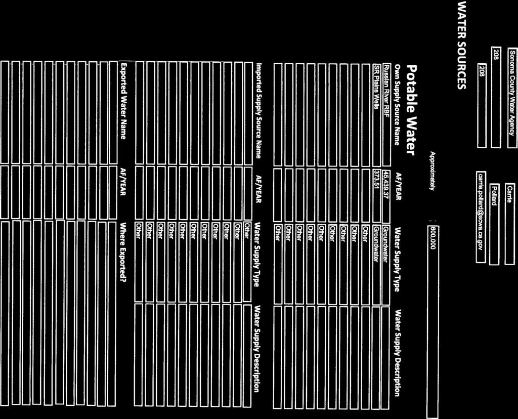

95
96


97


98


99


100


101

102
103
104 Appendix C: Water Shortage Contingency Plan C
105
106 Sonoma County Water Agency 2010 UWMP Water Shortage Contingency Plan This water shortage contingency analysis contains the elements required by Water Code section 10632, including actions in the event of a water shortage, information on the estimated multiple dry-year minimum water supply, information on emergency preparedness and plans for catastrophic events, prohibitions, penalties, and consumption reduction methods, revenue impacts caused by reduced water sales during shortages, and a shortage contingency resolution and mechanisms for determining actual reductions in use during a shortage. As a water wholesaler, the Water Agency does not have the ability to impose use restrictions or other requirements directly on end users of water in the event of a shortage; such actions must be taken by the Water Agency s Customers. Accordingly, this water shortage contingency analysis is limited to those actions that the Water Agency can take vis-à-vis its retail customers in the event of a water shortage. The minimum water supply available during the next few years during a multiple year drought is presented in Table 4-16 of the Water Agency s 2010 Urban Water Management Plan. No supply reduction is projected under this scenario, although as noted in Sections and 6.3 of the Plan, given the relatively low modeled storage levels in Lake Mendocino during some portions of the 4 consecutive dry-year scenario, it is likely that some demand management measures by Russian River water users, including Water Agency customers, would be implemented to maintain higher Lake Mendocino storage levels than shown in Table 4-6. Stages of Action to be Taken in Response to Water Supply Shortages (Water Code 10632(a)) Section 3.5(a) of the Restructured Agreement for Water Supply describes the manner in which the Water Agency is to allocate water to its customers in the event of a water supply shortage, and Section 3.5(b) of the Restructured Agreement describes the manner in which the Water Agency is to allocate water to its customers in the event of a temporary impairment of the capacity of some or all of the Water Agency s transmission system. Section 3.5(d) of the Restructured Agreement requires the Water Agency to have an adopted water shortage allocation methodology sufficient to inform each Customer of the water that would be available to it pursuant to Section 3.5(a) in the event of reasonably anticipated shortages, which methodology shall be consistent with this Section 3.5 and shall be included in the Urban Water Management Plan prepared pursuant to Section 2.7. On April 18, 2006, the Water Agency s Board of Directors adopted Resolution No , which approved a water allocation methodology developed by the Water Agency and the water contractors. Resolution No recognized that the methodology could be modified in the future as additional data regarding customer demands, local supply, and recycled water became available or changed. In order to address changes that have occurred over the last five years, the Water Agency is in the process of updating the water allocation methodology and anticipates completing the update by the fall of In addition, the Water Agency s water rights permits contain a term requiring the Water Agency to impose a mandatory thirty percent deficiency in deliveries from the Russian River whenever the quantity water in storage at Lake Sonoma drops below 100,000 acre-feet before July 15 of any year. The deficiency remains in effect until: 1. Storage in Lake Sonoma is greater than 70,000 ac-ft by December 31 of the same year; 2. The Water Agency has demonstrated to the Chief, Division of Water Rights, that storage in Lake Sonoma will not fall below 70,000 ac-ft; or 3. Hydrologic conditions result in sufficient flow to satisfy the Water Agency s demands at Wohler and Mirabel Park and minimum flow requirements in the Russian River near Guerneville. C-1
107 Sonoma County Water Agency 2010 UWMP One of the most important functions provided by the Water Agency is to monitor water supply conditions to gauge the likelihood of water shortages so that the Water Agency s wholesale customers will be prepared to respond to the shortages. The Water Agency constantly monitors the reservoir levels at Lake Pillsbury, Lake Mendocino, and Lake Sonoma, and estimates flows in and out of those reservoirs, as well as natural flows into and diversions from the Russian River and Dry Creek. By using this data as well as historical data regarding water use in different climatic conditions, the Water Agency can obtain an idea of when a water shortage may be imminent. As noted in Section 6 of the Water Agency s 2010 Urban Water Management Plan, except in a critically dry year, the Water Agency s water supplies are sufficient to meet its transmission system demands. If it appeared that a water supply shortage might occur, the Water Agency s first stage of action would be to notify its Customers and the general public of that possibility. Depending on the severity of the shortage, the Water Agency would work with its Customers to encourage voluntary demand reduction measures. The Water Agency would also encourage its Customers to maximize use of local water supplies. Finally, the Water Agency would take steps to publicize the potential shortage, and to encourage agricultural and non-water Agency-related diverters from the Russian River and Dry Creek to reduce diversions to the extent possible. If these voluntary measures were insufficient, or if climatic conditions (or the 30% cutback provision in the Water Agency s water rights permits was triggered) were likely to lead to a situation in which transmission system demands would exceed the Water Agency s available water supply, the Water Agency would then calculate the amount of water available to its water contractors, other water transmission system customers, Russian River customers, and MMWD under existing contractual provisions, including Section 3.5 of the Restructured Agreement, by using the then-existing allocation methodology adopted pursuant to Section 3.5(d) of the Restructured Agreement. In the event of a severe water supply shortage, the Water Agency could also petition the State Water Resources Control Board for temporary relief from the minimum instream flow requirements in the Russian River and Dry Creek, in order to conserve the remaining water supply in Lake Sonoma and Lake Mendocino. Table 1 presents the stages of action. 1 2 Table 1. Water Shortage Contingency Rationing Stages to Address Water Supply Shortages Stage No. Water Supply Conditions % Shortage Total system storage level and rate of decline and Water Agency customer demands Total system storage level and rate of decline and Water Agency customer demands 0 to to 65 Under the allocation methodology currently adopted by the Water Agency, in the event of a 50% cutback in the Water Agency s Russian River water supply, the amounts allocated to contractors and others would be as presented in Table 2 (assumes available water supply is 39,800 ac-ft, which is 50% of the 75,000 ac-ft of Russian River diversions plus 2,300 ac-ft of groundwater production). It is possible that the Water Agency s groundwater wells could produce more than 2,300 ac-ft during a water supply shortage condition. C-2
108 Sonoma County Water Agency 2010 UWMP Regular Customers Table 2. Allocations Cotati 689 Petaluma 6,129 Rohnert Park 2,906 Sonoma 1,253 Windsor (From Transmission System) 315 North Marin Water District (MMWD) 4,751 Santa Rosa 16,787 Valley of the Moon Water District 2,147 Other Water Agency Customers 946 Sub-Total 35,922 Marin Municipal Water District 712 Russian River Customers (includes Windsor direct diversions) 3,166 Total 39,800 Allocation, ac-ft/yr Catastrophic Supply Interruption Plan - Water Code Section (c) An occurrence where there is an insufficient amount of available water to meet the region s needs because of a disaster is considered a catastrophic water shortage. Sudden interruption of water supply with no to minimal advance warning can be caused by events that include earthquakes, toxic spills, and power outages. The Act requires urban water agencies to provide a catastrophic supply interruption plan. In accordance with the Emergency Services Act, the Water Agency has developed an Emergency Operation Plan (EOP). The EOP guides response to unpredicted catastrophic events that might impact water delivery. The EOP outlines standard operating procedures for all levels of emergency, from minor accidents to major disasters and are coordinated with the water contractors EOPs. Table 3 summarizes the actions to be implemented by the Water Agency in the event of specific catastrophic events. In addition to the Water Agency s actions, the water contractors and MMWD would initiate their own actions to address a catastrophic water supply interruption in accordance with their own water shortage contingency plans. Many of the Water Agency s customers have local water supplies that would be relied upon during the period of water supply interruption. C-3
109 Sonoma County Water Agency 2010 UWMP Earthquake Toxic Spills Fire Possible Catastrophe Power outage or grid failure Severe winter storms Hot weather Table 3. Preparation Actions for a Catastrophe Summary of Actions Shut-off isolation valves and above ground use of flexible piping for ruptured mains. Initiate rapid repair of damaged water facilities. Use of groundwater wells. Storage supplies for fire flows. Portable and emergency generators available for most Water Agency facilities Portable and emergency generators available for most Water Agency facilities Portable and emergency generators available for most Water Agency facilities Prohibitions, Penalties, and Consumption Reduction (Water Code 10632(d)-(f)) As noted earlier, as a wholesale supplier, the Water Agency has no ability to directly restrict the use of water by end users, or to impose financial penalties on end users for excessive use. However, under the Restructured Agreement, the Water Agency has a number of methods available to it to ensure that its contractors do not use more than the amount of water allocated by the Water Agency during a time of shortage. Under Section 3.5(e) of the Restructured Agreement, a contractor taking more than its allocated amount of water during a shortage is subject to a liquidated damages surcharge equal to 50% of the thencurrent operations and maintenance charge for each acre-foot of water taken by the contractor in excess of its allocation. Section 3.5(e) also reserves to the Water Agency all other rights it may have to limit contractors and other customers to their allocated amounts, including physically limiting the quantity of water taken to the amounts allocated, and pursuing all other available legal and equitable remedies applicable to such violations. Finally, Section 3.5(e) allows the Water Advisory Committee to request that the Water Agency physically limit the quantity of water taken by a Regular Customer to the amounts authorized by Section 3.5, or pursue all other available legal and equitable remedies applicable to such violations. In addition to these methods of reducing consumption, water contractors have ordinances placing limitations on the uses of water by end customers in the event of a water shortage. These ordinances were developed in consultation with the Water Agency and are described in detail in the water contractor s individual Urban Water Management Plans. Tables 4, 5, and 6 present the mandatory provisions, consumption reduction methods, and penalties and charges, respectively. Table 4. Water Shortage Contingency Mandatory Prohibitions (DWR Table 36) Examples of Prohibitions Use of Water in Excess of Allocation under Section 3.5 of Restructured Agreement or other contractual provision Stage When Prohibition Becomes Mandatory Stage 2 C-4
110 Sonoma County Water Agency 2010 UWMP Table 5. Water Shortage Contingency Consumption Reduction Methods (DWR Table 37) Consumption Reduction Methods Notification of Potential Water Shortage Stage 1 Encourage Reduction in Use by Customers, RR Diverters, and Agricultural Diverters through Public Outreach Stage When Method Takes Effect Stage 1 Projected Reduction (%) Varies Imposition of Section 3.5 Allocations Stage 2 Varies Table 6. Water Shortage Contingency Penalties and Charges (DWR Table 38) Penalties or Charges Liquidated Damage Surcharge for Taking in Excess of Allocation Physical Limitation on Deliveries to Customers Taking in Excess of Allocation Legal Remedies against Customers Taking in Excess of Allocation Stage When Penalty Takes Effect Stage 2 Stage 2 Stage 2 Analysis of Revenue Impacts of Reduced Sales during Shortages (Water Code 10632(g)) Although a water shortage would result in reduced water deliveries by the Water Agency, a water shortage would not have any material impacts on the Water Agency s financial condition. Under the Restructured Agreement, the Water Agency imposes charges on the contractors and other customers on an ac-ft basis. The charges are set in an amount necessary to produce revenues to meet the Water Agency s revenue bond obligations and expected operations and maintenance, and to produce a prudent reserve in an amount determined by the Water Advisory Committee. Charges are set annually each spring to be effective for the following fiscal year (July 1 to June 30). In computing the charges, the Restructured Agreement requires the Water Agency to assume that the amount of water to be delivered from each aqueduct of the transmission system will be the same as the amount of water delivered from said aqueduct during the twelve months preceding such establishment, or the average annual amount of water delivered during the preceding 36 months, whichever is less. In addition, however, the Restructured Agreement provides that [i]f because of drought or other water-supply reduction, state or federal order, or other similar condition, the Water Agency anticipates that any such quantities will not be predictive of future usage, the Water Agency may use a different amount with the prior approval of the Water Advisory Committee. Thus the Water Agency has the ability to increase water rates, with Water Advisory Committee approval, in order to address a pending water supply shortage. C-5
111 Sonoma County Water Agency 2010 UWMP In addition, in order to protect the interest of the holders of revenue bonds issued to finance transmission system facilities, the Restructured Agreement provides that it is the intention of the parties that the charges set forth herein will be sufficient to pay the Revenue Bonds and to meet the Revenue Bond Obligations not met from other sources of funds, and that the contractors agree to pay promptly such charges notwithstanding any deficiency in the quantity or quality of water to which they or any of them would be entitled pursuant to this Agreement. The term Revenue Bond Obligations includes the Water Agency s operations and maintenance costs. The Restructured Agreement thus requires the contractors to ensure that the Water Agency has sufficient funds to operate and maintain the transmission system, and to pay off the holders of revenue bonds, notwithstanding a water supply shortage leading to a reduction in deliveries. A water shortage would reduce the Water Agency s transmission system expenses. The biggest component of the Water Agency s transmission system expenses is the cost of electrical power to pump water from the Russian River and deliver it through the various aqueducts to its customers. The less water the Water Agency pumps, the less the Water Agency pays for power; thus a water shortage would reduce, not increase, the Water Agency s transmission system expenses. Table 7 summarizes the measures to overcome revenue impacts. As stated above, expenditures would be reduced during a water shortage due primarily to less pumping costs; therefore no expenditure impact mitigation measures are defined. Table 7. Proposed Measures to Overcome Revenue Impacts Names of Measures Summary of Effects Rate adjustments Offset loss in revenue Use of financial reserves Offset loss in revenue Water Shortage Contingency Resolution and Use Monitoring Procedure (Water Code 10632(h) and (i)) As noted above, the Water Agency s Board has adopted a resolution approving an allocation methodology for use by the Water Agency in the event of a water supply shortage. That resolution is attached as Attachment 1. Each of the Water Agency's contractors would adopt a water shortage contingency resolution in the event of a water shortage If the Water Agency allocates water supplies to its contractors and customers pursuant to Section 3.5 of the Restructured Agreement, other contractual provisions, and the allocation methodology, the Water Agency will monitor compliance with the allocation by increasing the frequency of its readings of meters showing the amount of water being taken by its contractors and customers. Table 8 presents the monitoring mechanisms. Table 8. Water Use Monitoring Mechanisms Mechanisms for determining actual reductions Data Expected Meter Reading Water Used by each Contractor/Customer C-6
112 Sonoma County Water Agency 2010 UWMP Attachment 1: Resolution No C-7
113
114
115
116 Appendix D: Urban Water Management Plan Checklist D
117
118 Sonoma County Water Agency 2010 UWMP Table D-1 Urban Water Management Plan checklist, organized by legislation number No. UWMP requirement a Calif. Water Code reference Subject b Additional clarification UWMP location 1 Provide baseline daily per capita water use, urban water use target, interim urban water use target, and compliance daily per capita water use, along with the bases for determining those estimates, including references to supporting data. 2 Wholesalers: Include an assessment of present and proposed future measures, programs, and policies to help achieve the water use reductions. Retailers: Conduct at least one public hearing that includes general discussion of the urban retail water supplier s implementation plan for complying with the Water Conservation Bill of Report progress in meeting urban water use targets using the standardized form. 4 Each urban water supplier shall coordinate the preparation of its plan with other appropriate agencies in the area, including other water suppliers that share a common source, water management agencies, and relevant public agencies, to the extent practicable. 5 An urban water supplier shall describe in the plan water management tools and options used by that entity that will maximize resources and minimize the need to import water from other regions (e) (a) System Demands System Demands Retailer and wholesalers have slightly different requirements Not applicable Standardized form not yet available Not applicable (refer to individual Water Agency Contractors UWMPs) Section Not applicable (refer to individual Water Agency Contractors UWMPs) 10620(d)(2) Plan Preparation Section 1.3 and Appendix A 10620(f) Water Supply Reliability Section 1.2, Section D-1
119 Sonoma County Water Agency 2010 UWMP No. UWMP requirement a Code reference Subject b Additional clarification UWMP location Calif. Water 6 Every urban water supplier required to prepare a plan 10621(b) Plan Preparation Section 1.4 pursuant to this part shall, at least 60 days prior to the public hearing on the plan required by Section 10642, notify any city or county within which the supplier provides water supplies that the urban water supplier will be reviewing the plan and considering amendments or changes to the plan. The urban water supplier may consult with, and obtain comments from, any city or county that receives notice pursuant to this subdivision. 7 The amendments to, or changes in, the plan shall be adopted 10621(c) Plan Preparation Section 1.4 and filed in the manner set forth in Article 3 (commencing with Section 10640). 8 Describe the service area of the supplier 10631(a) System Section 2.1 Description 9 (Describe the service area) climate 10631(a) System Description Section (Describe the service area) current and projected population... The projected population estimates shall be based upon data from the state, regional, or local service agency population projections within the service area of the urban water supplier (population projections) shall be in five-year increments to 20 years or as far as data is available. 12 Describe... other demographic factors affecting the supplier's water management planning 10631(a) 10631(a) 10631(a) System Description System Description System Description Provide the most recent population data possible. Use the method described in Baseline Daily Per Capita Water Use. See Section M and 2040 can also be provided to support consistency with Water Supply Assessments and Written Verification of Water Supply documents. Section Section Section Section D-2
120 Sonoma County Water Agency 2010 UWMP No. UWMP requirement a Calif. Water Code reference Subject b Additional clarification UWMP location 13 Identify and quantify, to the extent practicable, the existing and planned sources of water available to the supplier over the same five-year increments described in subdivision (a). 14 (Is) groundwater... identified as an existing or planned source of water available to the supplier...? 15 (Provide a) copy of any groundwater management plan adopted by the urban water supplier, including plans adopted pursuant to Part 2.75 (commencing with Section 10750), or any other specific authorization for groundwater management. Indicate whether a groundwater management plan been adopted by the water supplier or if there is any other specific authorization for groundwater management. Include a copy of the plan or authorization. 16 (Provide a) description of any groundwater basin or basins from which the urban water supplier pumps groundwater. 17 For those basins for which a court or the board has adjudicated the rights to pump groundwater, (provide) a copy of the order or decree adopted by the court or the board 10631(b) System Supplies The existing water sources should be for the same year as the current population in line and 2040 can also be provided to support consistency with Water Supply Assessments and Written Verification of Water Supply documents (b) System Supplies Source classifications are: surface water, groundwater, recycled water, storm water, desalinated sea water, desalinated brackish groundwater, and other. Section 4.1 surface water Section 4.2 Russian River system model Section 4.3 groundwater Section 4.4 transfers and exchanges Section Desalination Section 4.6 recycled water Section (b)(1) System Supplies Section (b)(2) System Supplies Section Section (b)(2) System Supplies Section D-3
121 Sonoma County Water Agency 2010 UWMP No. UWMP requirement a Calif. Water Code reference Subject b Additional clarification UWMP location 18 (Provide) a description of the amount of groundwater the urban water supplier has the legal right to pump under the order or decree. 19 For basins that have not been adjudicated, (provide) information as to whether the department has identified the basin or basins as overdrafted or has projected that the basin will become overdrafted if present management conditions continue, in the most current official departmental bulletin that characterizes the condition of the groundwater basin, and a detailed description of the efforts being undertaken by the urban water supplier to eliminate the long-term overdraft condition. 20 (Provide a) detailed description and analysis of the location, amount, and sufficiency of groundwater pumped by the urban water supplier for the past five years. The description and analysis shall be based on information that is reasonably available, including, but not limited to, historic use records. 21 (Provide a) detailed description and analysis of the amount and location of groundwater that is projected to be pumped by the urban water supplier. The description and analysis shall be based on information that is reasonably available, including, but not limited to, historic use records. 22 Describe the reliability of the water supply and vulnerability to seasonal or climatic shortage, to the extent practicable, and provide data for each of the following: (A) An average water year, (B) A single dry water year, (C) Multiple dry water years. 23 For any water source that may not be available at a consistent level of use - given specific legal, environmental, water quality, or climatic factors - describe plans to supplement or replace that source with alternative sources or water demand management measures, to the extent practicable. 24 Describe the opportunities for exchanges or transfers of water on a short-term or long-term basis (b)(2) System Supplies Section 10631(b)(2) System Supplies Section (b)(3) System Supplies Section (b)(4) System Supplies Provide projections for 2015, 2020, 2025, and (c)(1) 10631(c)(2) Water Supply Reliability Water Supply Reliability Section Section 4.8 Section water supply strategies Section 4.9 climate change 10631(d) System Supplies Section 4.4 D-4
122 Sonoma County Water Agency 2010 UWMP No. UWMP requirement a Calif. Water Code reference Subject b Additional clarification UWMP location 25 Quantify, to the extent records are available, past and current water use, and projected water use (over the same five-year increments described in subdivision (a)), identifying the uses among water use sectors, including, but not necessarily limited to, all of the following uses: (A) Single-family residential; (B) Multifamily; (C) Commercial; (D) Industrial; (E) Institutional and governmental; (F) Landscape; (G) Sales to other agencies; (H) Saline water intrusion barriers, groundwater recharge, or conjunctive use, or any combination thereof;(i) Agricultural. 26 (Describe and provide a schedule of implementation for) each water demand management measure that is currently being implemented, or scheduled for implementation, including the steps necessary to implement any proposed measures, including, but not limited to, all of the following: (A) Water survey programs for single-family residential and multifamily residential customers; (B) Residential plumbing retrofit; (C) System water audits, leak detection, and repair; (D) Metering with commodity rates for all new connections and retrofit of existing connections; (E) Large landscape conservation programs and incentives; (F) High-efficiency washing machine rebate programs; (G) Public information programs; (H) School education programs; (I) Conservation programs for commercial, industrial, and institutional accounts; (J) Wholesale agency programs; (K) Conservation pricing; (L) Water conservation coordinator; (M) Water waste prohibition;(n) Residential ultralow-flush toilet replacement programs. 27 A description of the methods, if any, that the supplier will use to evaluate the effectiveness of water demand management measures implemented or described under the plan (e)(1) System Demands Consider past to be 2005, present to be 2010, and projected to be 2015, 2020, 2025, and Provide numbers for each category for each of these years (f)(1) DMMs Discuss each DMM, even if it is not currently or planned for implementation. Provide any appropriate schedules. Section 3.3 Not applicable (refer to individual Water Agency Contractors UWMPs) 10631(f)(3) DMMs Not applicable (refer to individual Water Agency Contractors UWMPs) D-5
123 Sonoma County Water Agency 2010 UWMP No. UWMP requirement a Calif. Water Code reference Subject b Additional clarification UWMP location 28 An estimate, if available, of existing conservation savings on water use within the supplier's service area, and the effect of the savings on the supplier's ability to further reduce demand. 29 An evaluation of each water demand management measure listed in paragraph (1) of subdivision (f) that is not currently being implemented or scheduled for implementation. In the course of the evaluation, first consideration shall be given to water demand management measures, or combination of measures, that offer lower incremental costs than expanded or additional water supplies. This evaluation shall do all of the following: (1) Take into account economic and noneconomic factors, including environmental, social, health, customer impact, and technological factors; (2) Include a cost-benefit analysis, identifying total benefits and total costs; (3) Include a description of funding available to implement any planned water supply project that would provide water at a higher unit cost; (4) Include a description of the water supplier's legal authority to implement the measure and efforts to work with other relevant agencies to ensure the implementation of the measure and to share the cost of implementation (f)(4) DMMs Not applicable (refer to individual Water Agency Contractors UWMPs) 10631(g) DMMs See 10631(g) for additional wording. Not applicable (refer to individual Water Agency Contractors UWMPs) D-6
124 Sonoma County Water Agency 2010 UWMP No. UWMP requirement a Calif. Water Code reference Subject b Additional clarification UWMP location 30 (Describe) all water supply projects and water supply programs that may be undertaken by the urban water supplier to meet the total projected water use as established pursuant to subdivision (a) of Section The urban water supplier shall include a detailed description of expected future projects and programs, other than the demand management programs identified pursuant to paragraph (1) of subdivision (f), that the urban water supplier may implement to increase the amount of the water supply available to the urban water supplier in average, single-dry, and multiple-dry water years. The description shall identify specific projects and include a description of the increase in water supply that is expected to be available from each project. The description shall include an estimate with regard to the implementation timeline for each project or program. 31 Describe the opportunities for development of desalinated water, including, but not limited to, ocean water, brackish water, and groundwater, as a long-term supply. 32 Include the annual reports submitted to meet the Section 6.2 requirement (of the MOU), if a member of the CUWCC and signer of the December 10, 2008 MOU (h) System Supplies Section (i) System Supplies Section (j) DMMs Signers of the MOU that submit the annual reports are deemed compliant with Items 28 and 29. Section 5.1 D-7
125 Sonoma County Water Agency 2010 UWMP No. UWMP requirement a Calif. Water Code reference Subject b Additional clarification UWMP location 33 Urban water suppliers that rely upon a wholesale agency for a source of water shall provide the wholesale agency with water use projections from that agency for that source of water in five-year increments to 20 years or as far as data is available. The wholesale agency shall provide information to the urban water supplier for inclusion in the urban water supplier's plan that identifies and quantifies, to the extent practicable, the existing and planned sources of water as required by subdivision (b), available from the wholesale agency to the urban water supplier over the same five-year increments, and during various water-year types in accordance with subdivision (c). An urban water supplier may rely upon water supply information provided by the wholesale agency in fulfilling the plan informational requirements of subdivisions (b) and (c). 34 The water use projections required by Section shall include projected water use for single-family and multifamily residential housing needed for lower income households, as defined in Section of the Health and Safety Code, as identified in the housing element of any city, county, or city and county in the service area of the supplier. 35 Stages of action to be undertaken by the urban water supplier in response to water supply shortages, including up to a 50 percent reduction in water supply, and an outline of specific water supply conditions which are applicable to each stage. 36 Provide an estimate of the minimum water supply available during each of the next three water years based on the driest three-year historic sequence for the agency's water supply. 37 (Identify) actions to be undertaken by the urban water supplier to prepare for, and implement during, a catastrophic interruption of water supplies including, but not limited to, a regional power outage, an earthquake, or other disaster. 38 (Identify) additional, mandatory prohibitions against specific water use practices during water shortages, including, but not limited to, prohibiting the use of potable water for street cleaning (k) System Demands Average year, single dry year, multiple dry years for 2015, 2020, 2025, and Section (a) System Demands Not applicable (refer to individual Water Agency Contractors UWMPs) Appendix C 10632(a) Water Supply Reliability 10632(b) Water Supply Reliability Section (c) Water Supply Reliability Appendix C 10632(d) Water Supply Reliability Appendix C D-8
126 Sonoma County Water Agency 2010 UWMP No. UWMP requirement a Calif. Water Code reference Subject b Additional clarification UWMP location 39 (Specify) consumption reduction methods in the most restrictive stages. Each urban water supplier may use any type of consumption reduction methods in its water shortage contingency analysis that would reduce water use, are appropriate for its area, and have the ability to achieve a water use reduction consistent with up to a 50 percent reduction in water supply. 40 (Indicated) penalties or charges for excessive use, where applicable. 41 An analysis of the impacts of each of the actions and conditions described in subdivisions (a) to (f), inclusive, on the revenues and expenditures of the urban water supplier, and proposed measures to overcome those impacts, such as the development of reserves and rate adjustments. 42 (Provide) a draft water shortage contingency resolution or ordinance. 43 (Indicate) a mechanism for determining actual reductions in water use pursuant to the urban water shortage contingency analysis. 44 Provide, to the extent available, information on recycled water and its potential for use as a water source in the service area of the urban water supplier. The preparation of the plan shall be coordinated with local water, wastewater, groundwater, and planning agencies that operate within the supplier's service area 45 (Describe) the wastewater collection and treatment systems in the supplier's service area, including a quantification of the amount of wastewater collected and treated and the methods of wastewater disposal. 46 (Describe) the quantity of treated wastewater that meets recycled water standards, is being discharged, and is otherwise available for use in a recycled water project (e) 10632(f) 10632(g) 10632(h) 10632(i) Water Supply Reliability Water Supply Reliability Water Supply Reliability Water Supply Reliability Water Supply Reliability Appendix C Appendix C Appendix C Appendix C Appendix C System Supplies Section (a) System Supplies Section (b) System Supplies Section (Refer to individual customers UWMPs) D-9
127 Sonoma County Water Agency 2010 UWMP No. UWMP requirement a Calif. Water Code reference Subject b Additional clarification UWMP location 47 (Describe) the recycled water currently being used in the supplier's service area, including, but not limited to, the type, place, and quantity of use. 48 (Describe and quantify) the potential uses of recycled water, including, but not limited to, agricultural irrigation, landscape irrigation, wildlife habitat enhancement, wetlands, industrial reuse, groundwater recharge, indirect potable reuse, and other appropriate uses, and a determination with regard to the technical and economic feasibility of serving those uses. 49 (Describe) The projected use of recycled water within the supplier's service area at the end of 5, 10, 15, and 20 years, and a description of the actual use of recycled water in comparison to uses previously projected pursuant to this subdivision. 50 (Describe the) actions, including financial incentives, which may be taken to encourage the use of recycled water, and the projected results of these actions in terms of acre-feet of recycled water used per year. 51 (Provide a) plan for optimizing the use of recycled water in the supplier's service area, including actions to facilitate the installation of dual distribution systems, to promote recirculating uses, to facilitate the increased use of treated wastewater that meets recycled water standards, and to overcome any obstacles to achieving that increased use. 52 The plan shall include information, to the extent practicable, relating to the quality of existing sources of water available to the supplier over the same five-year increments as described in subdivision (a) of Section 10631, and the manner in which water quality affects water management strategies and supply reliability (c) System Supplies Section (Refer to individual customers UWMPs) 10633(d) System Supplies Not applicable (Refer to individual customers UWMPs) 10633(e) System Supplies Not applicable (Refer to individual customers UWMPs) 10633(f) System Supplies Not applicable (Refer to individual customers UWMPs) 10633(g) System Supplies Section Water Supply Reliability For years 2010, 2015, 2020, 2025, and 2030 Section 4.10 D-10
128 Sonoma County Water Agency 2010 UWMP No. UWMP requirement a Calif. Water Code reference Subject b Additional clarification UWMP location 53 Every urban water supplier shall include, as part of its urban water management plan, an assessment of the reliability of its water service to its customers during normal, dry, and multiple dry water years. This water supply and demand assessment shall compare the total water supply sources available to the water supplier with the total projected water use over the next 20 years, in five-year increments, for a normal water year, a single dry water year, and multiple dry water years. The water service reliability assessment shall be based upon the information compiled pursuant to Section 10631, including available data from state, regional, or local agency population projections within the service area of the urban water supplier. 54 The urban water supplier shall provide that portion of its urban water management plan prepared pursuant to this article to any city or county within which it provides water supplies no later than 60 days after the submission of its urban water management plan. 55 Each urban water supplier shall encourage the active involvement of diverse social, cultural, and economic elements of the population within the service area prior to and during the preparation of the plan. 56 Prior to adopting a plan, the urban water supplier shall make the plan available for public inspection and shall hold a public hearing thereon. Prior to the hearing, notice of the time and place of hearing shall be published within the jurisdiction of the publicly owned water supplier pursuant to Section 6066 of the Government Code. The urban water supplier shall provide notice of the time and place of hearing to any city or county within which the supplier provides water supplies. A privately owned water supplier shall provide an equivalent notice within its service area. 57 After the hearing, the plan shall be adopted as prepared or as modified after the hearing. 58 An urban water supplier shall implement its plan adopted pursuant to this chapter in accordance with the schedule set forth in its plan (a) Water Supply Reliability Section 6.1 Section (b) Plan Preparation Section Plan Preparation Section Plan Preparation Section Plan Preparation Section Plan Preparation Section D-11
129 Sonoma County Water Agency 2010 UWMP No. UWMP requirement a Calif. Water Code reference Subject b Additional clarification UWMP location 59 An urban water supplier shall submit to the department, the California State Library, and any city or county within which the supplier provides water supplies a copy of its plan no later than 30 days after adoption. Copies of amendments or changes to the plans shall be submitted to the department, the California State Library, and any city or county within which the supplier provides water supplies within 30 days after adoption. 60 Not later than 30 days after filing a copy of its plan with the department, the urban water supplier and the department shall make the plan available for public review during normal business hours (a) Plan Preparation Section Plan Preparation Section a The UWMP Requirement descriptions are general summaries of what is provided in the legislation. Urban water suppliers should review the exact legislative wording prior to submitting its UWMP. b The Subject classification is provided for clarification only. It is aligned with the organization presented in Part I of this guidebook. A water supplier is free to address the UWMP Requirement anywhere with its UWMP, but is urged to provide clarification to DWR to facilitate review. D-12

130 Prepared by Walnut Creek 201 N. Civic Drive Walnut Creek, CA Tel: