THE DAVIS BASIN DO NOT DELAY IN GETTING STARTED RIGHT AWAY!
|
|
|
- Ralf West
- 5 years ago
- Views:
Transcription
1 THE DAVIS BASIN This is not a lab. It is a project where you are representing your own consulting firm. Make up a catchy name if you like and have fun with it. However, you are expected to perform at a professional level and produce professional results!!!! Your output should be neat, look good, AND BE WELL THOUGHT OUT AND COMPLETE!!!! This project will require a lot of work, but you will find it worthwhile by the time you finish. DO NOT DELAY IN GETTING STARTED RIGHT AWAY!
 announces the opening of competition # SD431 to survey the hydrogeology of the Davis Basin.")
2 Memorandum To: Independent Consultants CC: Chair of Davis Development Committee From: Davis County Supervisor, Davis County Regional Office Re: Competition #: SD431 Competition Details: The Davis County Regional Office (DCRO) announces the opening of competition # SD431 to survey the hydrogeology of the Davis Basin. A contractor for this task will be chosen from among competitors based on the submission of a preliminary report. This report must include a summary of current information collected from the basin as well as suggestions for future data acquisition. The competition deadline is to be announced. No late entries will be accepted. Background: The County of Davis is currently interested in developing the Davis Basin. In order to fulfill this goal, a hydro-geological survey of the area is required. This will ensure that water resources are not compromised and that environmental regulations are complied with. Informational Meeting: An informational meeting will be held for all interested consulting firms this week in Room 232 (Kisiel Room) of the Harshbarger building. This meeting will provide further details on the objectives held by the County of Davis with respect to the future of the basin. Expectations regarding the preliminary reports will also be discussed. 2
3 i) Project Introduction Your company will be required to prepare a proposal for the further evaluation and interpretation of the hydrogeology of the study area. This will include the investigation of groundwater flow directions and the interactions between surface and ground water. A fundamental aspect of the project is the construction of a complete and accurate map. This map will be the basis for interpretations to be included in report format. ii) Background Information The given base map (to be supplied) represents a portion of a basin which is filled with unconsolidated sediments. Data from a reconnaissance survey indicate that granite bedrock outcrops are present above 1300 feet in the southwestern and northeastern parts of the study area. The region has a rainfall of less than 6 inches per year. The only stream that has water is shown on the base map as a solid black line; the dashed lines represent dry desert washes. There is a significant portion of the basin which is irrigated. The location of this area is discussed in Appendix 3. iii) Existing Data for the Davis Basin The DCRO has compiled all of the information relevant to this project from its files. A brief description of the existing basin data follows with the actual data tables located in Appendix 3. a) Benchmark Land Elevations Several locations in the basin have been established as benchmark land elevations. These points are used as a reference for the survey of all other locations/elevations within the basin. b) Well Locations / Water Levels All public and private wells in the basin must be registered with the DCRO. The record must include the location (see Appendix 1), land surface elevation and drilled depth for each well. The type of well completion must also be noted (see Appendix 2). c) Test Holes A small scale project exploring the lithology of the basin was conducted by I.B. Poor & Associates in Some of the driller s logs for cores taken during this project have been made available to the DCRO. These are the only subsurface geological data available to the DCRO at this time. d) Stream Gauging Project The DCRO has begun an intensive project, in cooperation with Davis County Community College, to monitor the stage of the Little Big River. There are currently three gauging stations in operation from which data are being collected. Results from this project are to be used in determining the nature of surface and groundwater interaction in the basin. 3
4 iv) Project Specifications a) Map Requirements - All maps submitted to the DCRO must be completed on a 18x24 map grid (Kueffel #487052, Plate 3) - All basin features present on the base map (to be provided) should be included (i.e. streams & washes) - The irrigated area should be clearly indicated by a red outline - Plot the locations and record the land and/or water level elevations for each well, bench mark, test hole, and stream gauging station beside each control point. Use the following symbols: - Triangle for bench mark (BM) - Open circle for stock or domestic wells (S, D) - X for river surface - Closed circles for test hole (TH) - Two concentric circles for irrigation well (I) - Prepare and include 100 foot contours for land surface elevation - Prepare and include 10 foot contours for the water table and/or potentiometric surface. Do not contour water levels in granite bedrock - Show all areas of natural recharge and discharge and the direction of groundwater flow in the basin. Also include any other features which you discover during your interpretation and are of interest. - Include all other standard mapping conventions (i.e. north arrow, legend, etc.) b) Report Requirements The DCRO will choose the contractor for an intensive basin study based on the quality of information outlined in the report. As such, the report should be complete and well thought out. It should include an introduction to the area, discussion of the geology/geologic history, interpretations of the groundwater flow system and surface water/groundwater interactions. A discussion of potential issues in the basin is also encouraged, i.e. potential for contamination of the resource, estimation of ground/surface water as major domestic supply, etc. Also, since the report is preliminary to a larger survey project, you should include an outline of your plan for the larger study. Include details about what information still needs to be obtained for a better quantification of the basin, what techniques you plan to use to get this information and cost information, if available. When completing this portion of your report, recall that the DCRO is on a limited budget and cannot afford outrageous expenses. 4
5 Appendix 1 The U.S. Public Land Grid Most land in the western United States has been divided according to the U.S. Public Land Grid. Using this system, surveys of land are referenced to principal meridians and baselines. These lines of reference, which intersect at 90o angles, have been established parallel to the universal coordinates of longitude and latitude, respectively (see Fig.A1-1). The survey grid is divided into six-mile squares called townships. The location of each township is given north or south of the base line and east or west of the principal meridian. Each township is further subdivided into thirty-six one mile squares called sections (note that sections are numbered both from left to right and right to left). Locations within each township are given by section and quarter section. The location of the data in the basin is given by township-range-section-quarter section (see Table 1). Note that a, b, c and d correspond to the north east, north west, south west, and south east quarter sections, respectively. Figure A1-1 The U.S. Public Land Survey Grid Appendix 2 Well Completion Water level data have been collected from three types of wells: stock wells, domestic wells, and irrigation wells. Domestic wells are used for drinking water and other household purposes. Stock wells are used to supply water for livestock. Both types of wells are commonly found in rural areas, beyond municipal supply systems. In the Davis Basin area, stock and domestic wells are constructed with solid casing (no perforations) and are open at the bottom. These wells can be constructed in confined or unconfined aquifers (see Fig. A2-1a & b). Irrigation well casings are perforated along their entire length and are surrounded by a filter pack. These wells are constructed to access all water bearing units in the borehole (see Fig. A2-2). 5


6 Figure A2-1 Construction of Stock and Domestic Wells: Wells are fully encased with no passage of water except at bottom of pipe. Figure A2-2 Construction of Irrigation Wells; Wells are fully screened and pump water from all aquifers. Appendix 3 DCRO Davis Basin Data The irrigated area in the Davis Basin is located in the following areas: - Sections 24 through 36 in T5S, R4E - All sections in T5S, R5E - Sections 7, 8, 9; 16 through 36 in T5S, R6E - All sections in T6S, R4E - All sections in T6S, R5E - All sections in T6S, R6E The following tables contain the data which is available for the basin from the DCRO. 6

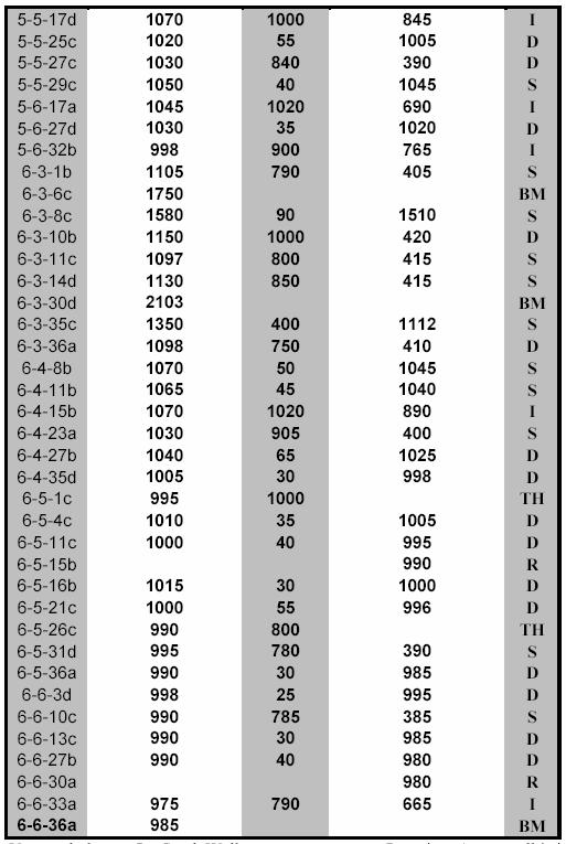
7 Table A3-1: Well Data 7
8 8
9 Table A3-2: Stream Discharge Data (all data in cfs) Table A3-3: Driller s Logs 9