ARIZONA s WATER RESOURCES & GROWTH. AG Outlook Forum
|
|
|
- Roland Reeves
- 5 years ago
- Views:
Transcription

1 ARIZONA s WATER RESOURCES & GROWTH AG Outlook Forum February 27, 2004 JIM HOLWAY Ph.D., ASSISTANT DIRECTOR ARIZONA DEPARTMENT OF WATER RESOURCES
2 Arizona s Water Resources & Growth Overview of water resources & drought Overview of water management in AZ Water resources & planning for growth Current activities & issues


3 WYOMING Orientation UTAH COLORADO NEVADA Prescott $ CALIFORNIA $ $ $ $ $ Phoenix NEW MEXICO Pinal $ $ $ $ Tucson MEXICO Santa Cruz

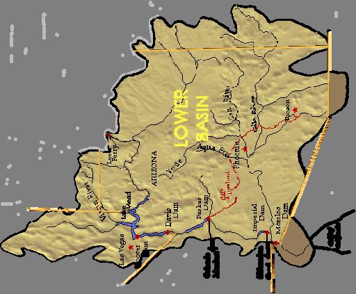
4 Upper/Lower Colorado River Basins
5 Williams SALT AND VERDE WATERSHED AND SRVWUA AREA Flagstaff VERDE RIVER WATERSHED KEY MAP Canyon Hell Creek Sedona Sycamore Creek Dry Beaver Creek Oak Verde River Watershed Verde SRVWUA Salt River Watershed Wet Beaver Creek Creek W. Clear Prescott Camp Verde River E. Verde River Haigler Creek Payson SALT RIVER WATERSHED Show Low Creek Wet Bottom Creek Tangle Creek Spring Creek Rye Corduroy Creek Carrizo Cibecue Cherry Creek N. Fork White River Slate Creek Creek Alpine Creek E. Fork White River Canyon Creek Black River E. Fork Creek Greenback Creek Tonto Black River W. Fork Creek Big Bonito Creek White River Salome Sycamore Creek Beaver Creek Sycamore Creek Fish Creek River New River Agua Fria River Black Pinal Creek SRV River River Creek Pinto Phoenix Globe Salt Salt WUA SCALE IN MILES Gila Gila River River North Wash Granite Creek Chino Big
6 SUPPLY (Source: ADWR) Water Source SURFACE WATER Colorado River CAP In-State Rivers GROUNDWATER RECLAIMED WATER Total Million Acre-Feet MAF % of total
7 OVERVIEW OF WATER RESOURCES IN ARIZONA ARIZONA DEPARTMENT OF WATER RESOURCES Year HISTORIC SUPPLY & DEMAND STATEWIDE WATER USE BY SOURCE 0% 50% 100% % of Total Use GW SW CAP EFF 1957 TOTAL USE 7,096,000 AF 1973 TOTAL USE 8,193,610 AF 1990 TOTAL USE 6,299,336 AF
8 CONSUMPTION 7% 25% Industrial Municipal Agricultural 68%
9 OVERVIEW OF WATER RESOURCES IN ARIZONA ARIZONA DEPARTMENT OF WATER RESOURCES Year HISTORIC SUPPLY & DEMAND STATEWIDE WATER USE BY SECTOR 1957 AG M&I % 50% 100% % of Total Use 1957 AG 6,800,000 AF M&I 296,000 AF 1973 AG 7,530,211 AF M&I 663,399 AF 1990 AG M&I 4,901,462 AF 1,309,565 AF

10 Water Use
11 WATER DEMAND CHARACTERISTICS arizona department of water resources phoenix ama 2000 Total Demand: 2.1 MAF ~ Demand by Sector ~ MUNICIPAL 47.62% INDUSTRIAL 6.00% Municipal use includes Palo Verde Nuclear Generating Facility NON-INDIAN AGRICULTURE 46.38%
12 arizona department of water resources phoenix ama 2,600,000 2,100,000 1,600,000 1,100, , ,000 AMA CHARACTERISTICS AMA Water Use By Source GW 47% of AMA Use 2000 GW 35% of AMA Use Groundwater (AF) Surface Water (AF) Effluent (AF)
13 PINAL AMA Water Demand 1998 Water Use Non-Indian Agriculture 81% Municipal 2% Indian Agriculture 16% Industrial 1% * Indian water use estimated on 1995 data Total AMA Water Demand 1,026,372 AF
14 Water Demand PINAL AMA Agricultural Water Use (Non-Indian) 1,000, , , ,000 acre-feet 600, , , , , , Groundwater CAP Water CAP In-Lieu Water Surface Water
15 Tucson AMA Demand Mining 12% Water Use for 1998 Other Indus. 4% Golf 6% Ag. 30% Muni. 48%
16 Tucson AMA Supply Water Use for 1998 Incidental recharge 26% Overdraft 34% Effluent 3% CAP water* 14% Natural recharge 23% *Includes direct & indirect recharge

17 Two-year Precipitation in the Colorado Basin

18 COLORADO RIVER SYSTEM Lake Powell: 45% Lake Mead: 60% Colorado System: 55% One year ago: 61% Source: USBR

19 SALT - VERDE STATUS Storage: 41% normal Jan. 2003: 27% 958,000 acre-feet Source: SRP

20

21 Winter Rains

22 100 Year Drought Index

23 Pacific Decadal Oscillation (PDO) Arizona Precipitation Warm - wetter Cold - dryer
 21 19 17 15 1900 1910 1920 WET 1930 1940 DR Y 1950")

24 23 AZ Climate Division 4 21 yr Mean Any Precipitation (inches) WET DR Y 1950 Year WET DRY? 2000 long-term oscillations or trends? Pacific Decadal Oscillation (PDO) - a long version of ENSO
25 COLORADO FLOWS (Source: University of Arizona) Legally Allocated 16.5 maf Measured, maf Deficit: (700,000 af) Historic Data (University of Arizona research) Estimated past flow averages: Tree rings, Upper Basin, maf Isotopes, Delta clams, maf Lowest 20-year average, maf
26 LOWER BASIN POPULATION (Source: Bureau of Census) California Total So. Cal. Total California Arizona Nevada Total Lower Basin ,264,500 37,473,500 5,553,849 2,403,097 29,221, ,909,900 45,821,900 7,363,604 2,611,453 (2010) 35,884,957
27 DROUGHT MITIGATION History: Drought was short-term Never had a plan Today: Governor s Drought Task Force Plan now being written Provides framework for mitigation Identifies triggers requiring action by city and state
28 Arizona Management Choices. Re-distributive Regulatory Constituent Distributive Regulatory Approach Management Areas vs Statewide State vs Regional/Local Control Groundwater / Surface Water Dichotomy. & Consequences
29 Groundwater Management Act Adopted in 1980 Legal Battles Over Rights to Water Political Efforts to Realize Completion of the CAP Overdrafting of Groundwater Supplies

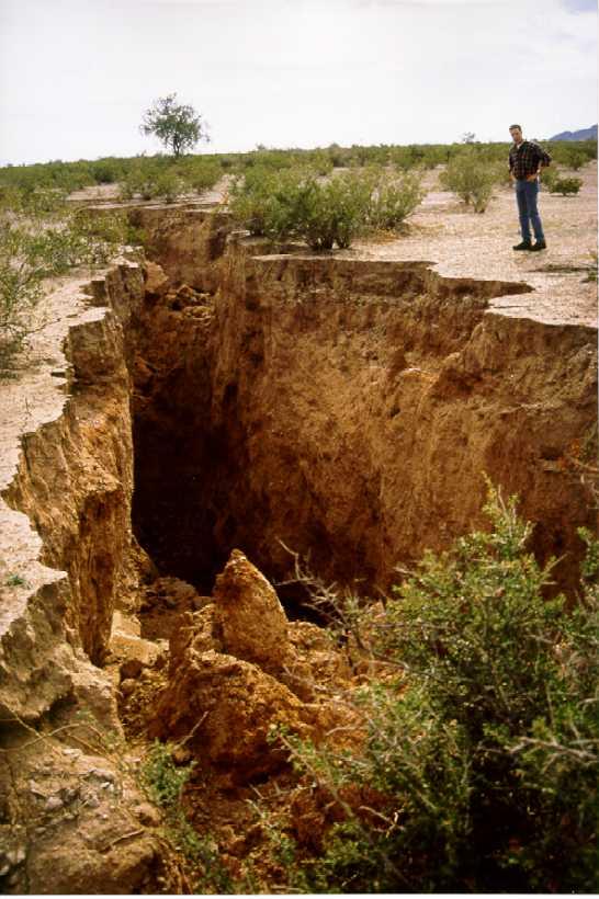
30 FISSURING SUBSIDENCE Drop 1991
31 Groundwater Management Act GOALS Control severe overdraft occurring in certain parts of Arizona. Provide a means to allocate the limited groundwater resources to most effectively meet the changing needs of the State. Augment Arizona s groundwater supplies through development of additional water supplies.
32 Arizona Department of Water Resources Management Structure State-Wide Provisions Irrigation Non-Expansion Areas; and Active Management Areas
33 ADWR - Water Management Statewide Water Management Programs Well Drilling (NOI) & Construction Groundwater Transfer Restrictions Adequate Water Supply Provisions Surface Water Rights Administration Tech Support to Adjudication Court Arizona Water Protection Fund Rural Watershed Initiatives Monitoring, Assessment & Tech Asst.
34 ADWR - Water Management IRRIGATION NON-EXPANSION AREAS Established 2 (now 3) Irrigation Non-Expansion Areas Joseph City Douglas Harquahala Valley (82)
35 Irrigation Non-Expansion Areas - INAs Notices of Irrigation Authority No New Agriculture Measurement & Reporting

 Pinal (1980)")

36 ADWR - Water Management ACTIVE MANAGEMENT AREAS Established 4 (now 5) Active Management Areas Phoenix (1980) Pinal (1980) Prescott (1980) Tucson (1980) Santa Cruz ( formerly part of Tucson
37 ADWR - Water Management MANAGEMENT GOALS OF AMAs Safe-Yield by 2025 Phoenix AMA - Prescott AMA Tucson AMA Safe-Yield long-term balance between amount of groundwater withdrawn in AMA and amount of natural and artificial groundwater recharge...
38 ADWR - Water Management MANAGEMENT GOALS OF AMAs Santa Cruz AMA maintain safe-yield and prevent local water tables from experiencing long-term declines Pinal AMA protect the agricultural economy as long as feasible, and preserve water supplies for future nonagricultural purposes
39 ARIZONA S S WATER MANAGEMENT TOOLS Active Management Areas Withdrawal Authorities Conservation Requirements & Use Restrictions Conversion to Renewable Water Supplies
40 ARIZONA S S WATER MANAGEMENT TOOLS - AMAs WITHDRAWAL AUTHORITIES Groundwater Withdrawal Rights and Permits Well Drilling Permits Measurement & Reporting Requirements
41 Groundwater Rights & Withdrawal Permits Irrigation Grandfathered Rights Type 1 Non-Irrigation Grandfathered Rights Type 2 Non-Irrigation Grandfathered Rights Service Area Rights Withdrawal Permits Recovery Well Permits Exempt Well Permits
42 Groundwater Withdrawal Permits Dewatering Temporary Dewatering Mineral Extraction & Metallurgical Processing General Industrial Use Poor Quality Groundwater Withdrawal Temporary Electrical Energy Generation Drainage Hydrologic Testing

43 Well Impacts - If proposed pumping causes >25 drawdown in <5 years. Waiver required - If proposed pumping causes between 10 and 25 drawdown. Mitigation or waiver required
44 ARIZONA S S WATER MANAGEMENT TOOLS - AMAs CONSERVATION REQUIREMENTS Five Management Plans: 1st Management Plan nd Management Plan rd Management Plan th Management Plan th Management Plan
45 ARIZONA S S WATER MANAGEMENT TOOLS - AMAs CONSERVATION REQUIREMENTS FOR: AGRICULTURE MUNICIPAL - Cities, Towns, Private Water Companies, and Irrigation districts INDUSTRIAL - Turf Facilities - Dairies/Feedlots - Power Generation - Large Cooling - Large Landscaping - Sand & Gravel - Mining
46 ARIZONA S S WATER MANAGEMENT TOOLS - AMAs CONSERVATION REQUIREMENTS Agricultural Users Prohibit new irrigated acreage BASE PROGRAM Allotments based on crops historically grown Expected irrigation efficiency increases - Now set at 80% NEW BMP PROGRAM
47 BMP Application Process BMP Worksheet - Organized into 4 categories - Each category allows a maximum score of 3 points - The applicant must score a minimum of 2 points in Category 2 to be accepted into the program - A total point value of at least 10 must be scored on the Worksheet to enter the BMP Program Categories of BMP Worksheet - Category 1: Water Conveyance Improvements - Category 2: Farm Irrigation Systems - Category 3: Irrigation Water Management - Category 4: Agronomic Management


48 Category 1 BMP Program Practices Water Conveyance System Improvements - Concrete-lined ditches, pipelines, gated-pipe, drain-back systems

49 Category 2 BMP Program Practices Farm Irrigation Systems - Slope systems without uniform grades with tail-water reuse - Uniform slope systems without tail-water reuse - Uniform slope systems with tail-water reuse - Uniform slope within an irrigation district that captures and redistributes return flows - Modified slope systems - High pressure sprinkler systems - Near level systems - Level systems - Low pressure sprinkler systems - Trickle or drip irrigation systems


50 Category 3 BMP Program Practices Irrigation Water Management (IWM) - Laser touch-up - Alternate row irrigation - Furrow checks - Angled rows - Surge irrigation - Temporary sprinklers - Participation in IWM programs - Using Irrigation Scheduling Services - Participation with I.D. to increase flexibility of water deliveries - Measure flow rates to determine amount of water applied - Soil moisture monitoring - Computer based model using meteorological data (AZMET)


51 Category 4 BMP Program Practices Agronomic Management - Crop rotation - Crop residue management - Soil and/or water quality testing - Pre-irrigation surface conditioning -Transplants - Plastic mulch or floatable row covers - Shaping furrows or beds - Planting in bottom of furrow
52 ARIZONA S S WATER MANAGEMENT TOOLS - AMAs CONSERVATION REQUIREMENTS Municipal Water Providers Per capita targets - GPCD Program Targets based on existing residential conservation potential & Models for New Housing Non-residential GPCD constant Best management practices Alternative Conservation Program Non Per Capita Conservation Program
53 ARIZONA S S WATER MANAGEMENT TOOLS - AMAs CONSERVATION REQUIREMENTS Industrial Users - Turf facilities >10 acres Allocation based on 75% irrigation efficiency New golf courses Assume 5 acres turf / hole & 0.4 acres of lake / hole Additional low water use landscaping
54 ARIZONA S S WATER MANAGEMENT TOOLS - AMAs Additional Conservation Regulations - Distribution Systems - New Public Rights-of-Way - Lakes Bill Prohibitions - BMP s for Mines, Sand & Gravel, Power Plants, Industrial Users - Dairies & Feedlots and Cooling Towers
55 ARIZONA S S WATER MANAGEMENT TOOLS - AMAs CONVERSION TO RENEWABLE SUPPLIES Incentives for use of Renewable Supplies Assured Water Supply Requirements for New Subdivisions Underground Storage / Recovery Permits
56 ARIZONA S S WATER MANAGEMENT TOOLS - AMAs CONVERSION TO RENEWABLE SUPPLIES Assured Water Supply Rules Requires 100 year supply Must be consistent with AMA Goal e.g. safe yield Combines Demand & Supply Management
57 ARIZONA S S WATER MANAGEMENT TOOLS - AMAs CONVERSION TO RENEWABLE SUPPLIES Underground Storage & Recovery Program Encourage use of renewable supplies through storage and later recovery Make use of supplies with less treatment & distribution infrastructure Utilize Arizona s Colorado River entitlement & Firming Assist communities in meeting Assured Water Supply
58 ARIZONA S S WATER MANAGEMENT TOOLS - AMAs Underground Storage/Recovery Permits Storage Facility Permits Underground Storage Facility (USF) Constructed Managed Groundwater Savings Facility (GSF) Water Storage Permits Recovery Well Permits & Criteria

59 Underground Storage Facility Applicant must demonstrate: Technical & financial capability Storage is hydrologically feasible No unreasonable harm water levels water quality Floodplain permits and APP for Effluent Permits

60 Groundwater Savings Facility Applicant must demonstrate: Permits Direct Reduction of groundwater pumping Groundwater pumper agrees to curtail pumping In-lieu water is the only reasonable alternative to groundwater Through the development of a Plan of Operation
61 ARIZONA S S WATER MANAGEMENT TOOLS Arizona s -- Additional Water Management Tools Arizona Water Banking Authority Water Rights Settlements Surface Water Rights Administration Grants for Conservation, Augmentation, & Monitoring Technical Planning and Assistance & Rural Studies
62 PLANNING FOR GROWTH Assured Water Supply Rules - In AMA s Requires 100 year supply Must be consistent with AMA Goal e.g. safe yield - can not mine groundwater Combines Demand & Supply Management
63 Assured Water Supply Criteria Physical, Legal, & Continuous Availability for 100 Years Adequate Quality Financial Capability Consistent with Conservation Targets Consistent with AMA Goals Safe-yield in Phoenix, Tucson, Prescott AMAs
64 Subdivision Requirements and Assured Water Supply Subdivision: land divided into six or more parcels where at least one parcel is less than 36 acres, which is offered for sale or lease for more than one year An assured water supply is required: to gain approval of a subdivision plat by local governments (Titles 9 and 11) to obtain authorization to sell lots from the Department of Real Estate (Title 32)
65 Methods of Meeting Goal Requirement Use of renewable supplies (either directly or via underground storage and recovery): Surface water Effluent Membership in the Central Arizona Groundwater Replenishment District Groundwater imported from certain basins Dry lot subdivisions of less than 20 lots are exempt
66 Central Arizona Groundwater Replenishment District (CAGRD) Acquires supplies to replace groundwater pumped by its members Replacement water is recharged into aquifers within the AMA Net effect: no new groundwater pumping
67 Two means of establishing an Assured Water Supply: Certificate of Assured Water Supply (individual subdivision) Designation of Assured Water Supply (blanket for water provider)
68 Certificate of Assured Water Supply Required for each new subdivision if service will be from a provider that is not designated
69 Designation of Assured Water Supply A water provider (city, town or private water company) can demonstrate that they meet the AWS criteria for: existing water demands committed demands at least 2 years of projected growth No Certificates of AWS necessary
70 Example #2 CAGRD Member Land Subdivision developer applies to ADWR for Certificate of Assured Water Supply CAWS ADWR Subdivision Home Provider pumps groundwater and serves it to homeowner Provider reports total water use to ADWR, and individual homeowner water use to CAGRD CAGRD reports homeowner s replenishment assessment to County Assessor Assessor collects assessment on property tax bill, and sends money to CAGRD Facility Operator Recharge Basin CAGRD CAWCD CAP Water County Assessor Water Provider Groundwater CAGRD arranges with CAWCD to deliver CAP water to recharge facility permitted by ADWR Recharge Facility Operator reports deliveries to ADWR, which calculates recharge credits ADWR reports credits to CAGRD, which uses credits to meet homeowner s replenishment
71 PLANNING FOR GROWTH Adequate Water Supply Rules - Rest of State (Outside AMA s) Requires determination of 100 year supply Development can proceed with either inadequate or adequate supply Determination becomes part of public report for 1st sale only
72 Designations of Adequacy & Adequacies Issued
73 Designated Water Providers

74 Certificates of Assured Water Supply Issued
75 PLANNING FOR GROWTH Growing Smarter - General Plans Water Resources Element Required for Cities & Towns > 2,500 (unless under 10,000 with growth < 2%/year) Required for Counties > 125,000 pop 4 counties and 23 communities outside of AMAs qualify
76 PLANNING FOR GROWTH Growing Smarter - Requirements Identify known legally and physically available supplies Identify future demand Identify how demand will be served by currently available supplies or a plan to obtain additional necessary water supplies
77 CURRENT ACTIVITIES & ISSUES Growth & Water Mgmt Trends - Phx Area Legislative & Other Water Mgmt Proposals Within AMA s Exempt Wells Recreation Corridor Channelization District CAGRD Plan of Operation Outside AMA s Adequacy Program Well Impacts & Exempt Wells Growing Smarter Modifications
78 EMERGING WATER ISSUES Competition for Water Supplies Conflicts over Water, Growth & Property Rights Certain Rural Areas Reaching Limits of Supply Environmental Concerns Groundwater vs. Surface Water Need for Regional & Coordinated Mgmt State Budget

79