SAN GORGONIO PASS WATER AGENCY SUPPLEMENTAL WATER SUPPLY PLANNING STUDY
|
|
|
- Johnathan Foster
- 5 years ago
- Views:
Transcription

1
 686-1070 Sam I. Gershon, R.C.E. R.C.E. No.")
2 SAN GORGONIO PASS WATER AGENCY SUPPLEMENTAL WATER SUPPLY PLANNING STUDY Prepared By: ALBERT A. WEBB ASSOCIATES 3788 McCray Street Riverside, CA (951) Sam I. Gershon, R.C.E. R.C.E. No. C14489 October, 2009
3 TABLE OF CONTENTS EXECUTIVE SUMMARY ES-1 SECTION 1 - INTRODUCTION 1-1 Purpose Of the Study 1-2 History 1-2 State Water Project 1-2 Integrated Water Resources Plan 1-4 Strategic Plan 1-5 Beaumont Groundwater Basin 1-5 Study Area 1-6 Major Water Retailers 1-7 SECTION 2 - WATER DEMAND PROJECTION 2-1 SGPWA Service Area and Approved General Land use Plan 2-1 Water Demand Projections 2-2 Water Demand Based on Population and/or Housing 2-2 Urban Water Management Plans 2-5 Ultimate Water Demand Based on Land Use Projection 2-6 SECTION 3 - LOCAL WATER SUPPLY 3-1 Beaumont Cherry Valley Water District 3-1 City of Banning Water Department 3-2 Cabazon Water District 3-3 South Mesa Water Company 3-3 Yucaipa Valley Water District 3-3 Total Local Water Supply within SGPWA Service Area 3-4 SECTION 4 - SUPPLEMENTAL STATE WATER PROJECT WATER DEMAND 4-1 SECTION 5 - NEW SGPWA FACILITIES TO MEET DEMAND FOR SUPPLEMENTAL SWP WATER 5-1 Existing and Proposed Facilities 5-1 East Branch Extension Phase II 5-1 State Water Project Aqueduct Extension 5-2 Lucerne Valley Alignment 5-5 Lucerne Valley Loop Pipeline 5-7 North Pass Alignment 5-9 Independent SGPWA North Pass Alignment 5-11 Inland Feeder Modified Pass Alignment 5-12 A L B E R T A. WEBB A S S O C I A T E S i G:\2007\ \Report\003 Final Report\Body.docx
4 TABLE OF CONTENTS SECTION 6 - PROJECT COST ESTIMATES 6-1 Cost Estimate Criteria 6-1 Lucerne Valley Alignment Cost Analysis 6-1 North Pass Alignment Cost Analysis 6-4 Independent SGPWA North Pass Alignment Cost Analysis 6-6 Inland Feeder Modified Pass Alignment Cost Analysis 6-7 Summary of TOTAL Costs 6-10 Cost Analysis of Changing Pipeline Velocity 6-12 Contingencies Cost Analysis 6-13 SECTION 7 - FINDINGS, CONCLUSIONS AND RECOMMENDATIONS 7-1 Findings 7-1 Study Area 7-1 Ultimate Demand Projections 7-1 Total Local Water Supply for SGPWA 7-2 Reliability and Delivery Requirements 7-3 Current and Future Capacities Owned by SGPWA 7-4 Delivery Facilities 7-5 Cost Evaluation 7-8 Project Phasing and Implementation 7-10 Conclusions 7-15 Cost Evaluations 7-15 Implementation 7-16 Recommendations 7-16 LIST OF TABLES Table 2-1: SGPWA Service Area (1) 2-1 Table 2-2: San Gorgonio Pass Water Agency Projection of Housing Units and Population within SGPWA 2-4 Table 2-3: SGPWA Projected Water Demand Based Upon Population or DU s 2-5 Table 2-4: Water Demand in the San Gorgonio Pass Water Agency Service Area by Major Water Retailers Based upon Urban Water Management Plans 2-6 Table 2-5: Water Demand Factors 2-7 Table 2-6: Morongo Tribal Lands Slope Analysis 2-7 Table 2-7: Water Retailer Areas Including Sphere of Influence Boundaries 2-8 Table 2-8: Ultimate Water Demand for Major Water Retailers, Unincorporated County, and Morongo Tribal Lands 2-9 A L B E R T A. WEBB A S S O C I A T E S ii G:\2007\ \Report\003 Final Report\Body.docx
5 Table 2-9: TABLE OF CONTENTS SGPWA Projected Ultimate Water Demand Compared with Projected 2030 Demand for Major Water Retailers within SGPWA s Service Area 2-10 Table 2-10: Potential Ultimate Water Demand for the San Gorgonio Pass Water Agency Service Area 2-10 Table 3-1: BCVWD Local Water Supply (1) 3-2 Table 3-2: BWD Local Water Supply (1) 3-2 Table 3-3: SMWC Local Water Supply (1) 3-3 Table 3-4: YVWD Local Water Supply (1) 3-4 Table 3-5: SGPWA Local Water Supply 3-4 Table 4-1: Potential Ultimate Water Demand for SGPWA 4-1 Table 4-2: Supplemental SWP Water Requirements 4-2 Table 4-3: SGPWA Incremental Demand, Local Supply and Supplemental SWP Water 4-3 Table 4-4: Average and Dry Period SWP Table A Deliveries From the Delta Under Current Conditions (1) 4-5 Table 4-5: Projected San Gorgonio Pass Water Agency Table A Water Requirements (1) 4-5 Table 4-6: Projected San Gorgonio Pass Water Agency Table A Water Capacity 4-6 Table 5-1: Supplemental SGPWA Delivery Requirements for State Water Project Water (Above an EBX Phase II Expanded Capacity of 64 cfs) 5-2 Table 5-2: Alternative Delivery Requirements Based on 63% Reliability 5-4 Table 5-3: Alternative Delivery Requirements Based on 80% Reliability 5-4 Table 5-4: Lucerne Valley Alignment Summary of Results for Required Additional Water Demand 5-5 Table 5-5: Lucerne Valley Alignment Pump Station Characteristics 5-6 Table 5-6: Lucerne Valley Alignment Hydro Power Station Characteristics 5-6 Table 5-7: Loop Pipeline Conveyance Criteria (1) 5-7 Table 5-8: Loop Pipeline Pump Station Characteristics 5-9 Table 5-9: North Pass Alignment Summary of Results for Required Additional Water 5-10 Table 5-10: North Pass Alignment Pump Station Characteristics 5-11 Table 5-11: Summary of Results for Independent SGPWA North Pass Alignment 5-11 Table 5-12: Independent SGPWA North Pass Alignment Pump Station Characteristics 5-12 Table 5-13: Summary of Results for Inland Feeder Modified Pass Alignment for SGPWA and Morongo Tribal Lands Water Demand 5-13 Table 5-14: Inland Feeder Modified Pass Alignment Pump Station Characteristics 5-13 A L B E R T A. WEBB A S S O C I A T E S iii G:\2007\ \Report\003 Final Report\Body.docx
6 TABLE OF CONTENTS Table 6-1: Allocated Capacity to CVWD, DWA, SGPWA and Morongo Tribal Lands for the Lucerne Valley and the North Pass Alignments (SWP 63% Reliability) 6-2 Table 6-2: Allocated Capacity to CVWD, DWA, SGPWA and Morongo Tribal Lands for the Lucerne Valley and the North Pass Alignments (SWP 80% Reliability) 6-2 Table 6-3: Allocated Capacity to SGPWA and Morongo Tribal Lands for the Loop Pipeline, Independent SGPWA North Pass Alignment and the Inland Feeder Modified Pass Alignment (SWP 63% Reliability) 6-2 Table 6-4: Allocated Capacity to SGPWA and Morongo Tribal Lands for the Loop Pipeline Alignment, Independent SGPWA North Pass Alignment, and the Inland Feeder Modified Pass Alignment (SWP 80% Reliability) 6-2 Table 6-5: Lucerne Valley Alignment Cost Summary (SWP 63% Reliability) 6-3 Table 6-6: Lucerne Valley Alignment Cost Summary (SWP 80% Reliability) 6-4 Table 6-7: North Pass Alignment Cost Summary (SWP 63% Reliability) 6-5 Table 6-8: North Pass Alignment Cost Summary (SWP 80% Reliability) 6-5 Table 6-9: Independent SGPWA North Pass Alignment Cost Summary (SWP 63% Reliability) 6-6 Table 6-10: Independent SGPWA North Pass Alignment Cost Summary (SWP 80% Reliability) 6-7 Table 6-11: Cost Allocation of MWD Inland Feeder (SWP 63% Reliability) (1) 6-7 Table 6-12: Cost Allocation of MWD Inland Feeder (SWP 80% Reliability) (1) 6-8 Table 6-13: Inland Feeder Modified Pass Alignment Cost Summary (SWP 63% Reliability) 6-8 Table 6-14: Inland Feeder Modified Pass Alignment Cost Summary (SWP 80% Reliability) 6-9 Table 6-15: Summary of Total Cost (SWP 63% Reliability) (1) 6-10 Table 6-16: Summary of Total Cost (SWP 80% Reliability) (1) 6-11 Table 6-17: Summary of Results of Cost Differential for 7 fps vs. 8 fps for North Pass Alignment (SWP 63% Reliability) 6-13 Table 6-18: SGPWA and Morongo Tribal Lands Project Cost Contingencies for Lucerne Valley Alignment Upsizing and Loop Pipeline for 63% Reliability 6-14 Table 6-19: SGPWA and Morongo Tribal Lands Project Cost Contingencies for North Pass Alignment Upsizing for 63% Reliability 6-14 Table 6-20: SGPWA and Morongo Tribal Lands Project Cost Contingencies for Independent SGPWA North Pass Alignment for 63% Reliability 6-14 Table 6-21: SGPWA and Morongo Tribal Lands Project Cost Contingencies for Inland Feeder Modified Pass Alignment for 63% Reliability 6-14 A L B E R T A. WEBB A S S O C I A T E S iv G:\2007\ \Report\003 Final Report\Body.docx
7 TABLE OF CONTENTS Table 6-22: SGPWA and Morongo Tribal Lands Project Cost Contingencies for Lucerne Valley Alignment Upsizing and Loop Pipeline for 80% Reliability 6-15 Table 6-23: SGPWA and Morongo Tribal Lands Project Cost Contingencies for North Pass Alignment Upsizing for 80% Reliability 6-15 Table 6-24: SGPWA and Morongo Tribal Lands Project Cost Contingencies for Independent SGPWA North Pass Alignment for 80% Reliability 6-15 Table 6-25: SGPWA and Morongo Tribal Lands Project Cost Contingencies for Inland Feeder Modified Pass Alignment for 80% Reliability 6-15 Table 7-1: Ultimate Water Demand for Major Water Retailers, Unincorporated County 7-2 Table 7-2: Potential Ultimate Water Demand for the San Gorgonio Pass Water Agency Service Area 7-2 Table 7-3: Supplemental SWP Water Requirements 7-3 Table 7-4: Projected San Gorgonio Pass Water Agency Table A Water Requirements (1) 7-4 Table 7-5: Projected San Gorgonio Pass Water Agency Table A Water Capacity 7-4 Table 7-6: SGPWA Current and Projected Capacity in State Water Project 7-4 Table 7-7: SGPWA Supplemental Delivery Requirements in a Future Importation Project 7-5 Table 7-8: Facilities Parameters for Lucerne Valley Alignment 7-6 Table 7-9: Facilities Parameters for North Pass Alignment 7-7 Table 7-10: Facilities Parameters for Independent North Pass Alignment 7-7 Table 7-11: Facilities Parameters for Inland Feeder Modified Pass Alignment 7-7 Table 7-12: Summary of Total Cost at 63% Reliability (1) Allocated to 7-9 Table 7-13: Summary of Total Cost at 80% Reliability (1) Allocated to 7-10 Table 7-14: SGPWA Supplemental Delivery Requirements Phased to Ultimate Buildout in Year Table 7-15: Implementation Date of SGPWA Supplemental Future Delivery Facilities 7-15 Table 7-16: Summary of Lowest Cost Alternatives to SGPWA (1) 7-15 LIST OF FIGURES Figure 1-1: Regional Location Map 1-8 Figure 1-2: SGPWA Boundary Map 1-9 Figure 4-1: SGPWA Incremental Demand, Local Supply and Supplemental SWP Water 4-4 Figure 7-1: SGPWA Projected Supplemental Delivery Requirements (SWP 63% Reliability) 7-13 A L B E R T A. WEBB A S S O C I A T E S v G:\2007\ \Report\003 Final Report\Body.docx
8 TABLE OF CONTENTS Figure 7-2: SGPWA Projected Supplemental Delivery Requirements (SWP 80% Reliability) 7-14 LIST OF PLATES Plate 1-1 SGPWA Aerial Map 1-10 Plate 1-2 SGPWA Major Water Retailers 1-11 Plate 2-1 SGPWA Cities, Counties and Morongo Tribal Lands Boundary Map 2-12 Plate 2-2 County of Riverside RCIP General Plan Land Use 2-13 Plate 2-3 City of Calimesa General Plan Land Use 2-14 Plate 2-4 City of Beaumont General Plan Land Use 2-15 Plate 2-5 City of Banning General Plan Land Use 2-16 Plate 2-6 General Plan Land Use within Agency Boundary 2-17 Plate 2-7 Riverside County Demographic Projection Units 2-18 Plate 2-8 Slope Analysis of Morongo Tribal Lands 2-19 Plate 2-9 Re-Categorized Land Use Designations within SGPWA Service Area Based on Water Retailers 2-20 Plate 5-1 DWR Existing and Proposed East Branch Extension 5-14 Plate 5-2 State Water Project Aqueduct Extension Alternative Alignments per August 2007 Development Plan 5-15 Plate 5-3 Lucerne Valley Alignment 5-16 Plate 5-4 Lucerne Valley Alignment Hydraulic Profile for 63% Reliability 5-17 Plate 5-5 Lucerne Valley Alignment Hydraulic Profile for 80% Reliability 5-18 Plate 5-6 Lucerne Valley Alignment Loop Pipeline 5-19 Plate 5-7 Lucerne Valley Alignment Loop Pipeline Hydraulic Profile For 63% Reliability 5-20 Plate 5-8 Lucerne Valley Alignment Loop Pipeline Hydraulic Profile For 80% Reliability 5-21 Plate 5-9 North Pass Alignment 5-22 Plate 5-10 North Pass Alignment Hydraulic Profile for 63% Reliability 5-23 Plate 5-11 North Pass Alignment Hydraulic Profile for 80% Reliability 5-24 Plate 5-12 Independent SGPWA North Pass Alignment 5-25 Plate 5-13 Independent SGPWA North Pass Alignment Hydraulic Profile for 63% Reliability 5-26 Plate 5-14 Independent SGPWA North Pass Alignment Hydraulic Profile for 80% Reliability 5-27 Plate 5-15 Inland Feeder-Modified Pass Alignment 5-28 A L B E R T A. WEBB A S S O C I A T E S vi G:\2007\ \Report\003 Final Report\Body.docx
9 TABLE OF CONTENTS Plate 5-16 Inland Feeder-Modified Pass Alignment Hydraulic Profile for 63% Reliability 5-29 Plate 5-17 Inland Feeder-Modified Pass Alignment Hydraulic Profile for 80% Reliability 5-30 APPENDICES A B C D E F G H County and Cities Land Use Designation within the SGPWA Boundaries Re-Categorized Land Use Designations within Boundaries and Spheres of Influence of Major Water Retailers Application of Unit Water Demand Factors to Re-Categorized Land Uses within Major Water Retailers SGPWA Supplemental Calculations and SWP Table A Supply Requirements Determination of Existing and Proposed Facilities Required to Convey Supplemental Water Demand Detailed Pump Calculations for State Water Project Aqueduct Extension Alternatives Cost Criteria per August 2007 Development Plan Cost Percentage Allocation Calculations I Project Cost Estimates for State Water Project Aqueduct Extension Alternatives for 63% Reliability J Operations Costs for State Water Project Aqueduct Extension Alternatives for 63% Reliability K Maintenance Costs for State Water Project Aqueduct Extension Alternatives for 63% Reliability L Project Cost Estimates for State Water Project Aqueduct Extension Alternatives for 80% Reliability M Operations Costs for State Water Project Aqueduct Extension Alternatives for 80% Reliability N Maintenance Costs for State Water Project Aqueduct Extension Alternatives for 80% Reliability O P Velocity Analysis Calculations Summary of Letter Reports and Correspondence regarding Conveyance and Recharge Facilities for Beaumont, Banning and Cabazon Basins A L B E R T A. WEBB A S S O C I A T E S vii G:\2007\ \Report\003 Final Report\Body.docx
10 EXECUTIVE SUMMARY The purpose of this study is to determine the following: 1. Future supplemental water supply needs of the San Gorgonio Pass Water Agency (SGPWA) service area under ultimate development; 2. Research the most efficient, economical, and reliable method of securing this supplemental water supply; and 3. Determine the general alignment, capacity, and cost of the recommended conveyance system. Future Water Supply Needs The study determined that by the year 2045 the SGPWA will have a total water demand of 94,000 acre-feet per year. Potential water supply available from local water sources, within SGPWA s service area, is projected to be 55,000 acre feet per year by year This will leave an incremental demand above the local water supply of 39,000 acre-feet per year 1 that SGPWA needs to secure by year An additional 20,000 acre-feet per year of supplemental water is required if the Morongo Band of Mission Indians tribal lands are included in the study. It is proposed that SGPWA secure this supplemental water supply from the State Water Project or other parties willing to sell water rights. (See Section 2 Water Demand Projection, Section 3 Local Water Supply, and Section 4 Supplemental State Water Project Water Demand) Securing Future Water Supply Conveyance Facilities The study analyzed several alternative conveyance facilities whereby SGPWA can convey the additional supplemental water supply needed to meet its future needs. (See Section 5 New SGPWA Facilities to Meet Demand for Supplemental SWP Water) Table A Water Entitlement Table A refers to a table in SGPWA s contract with the California Department of Water Resources (DWR) which defines the amount of water contracted for each year the contract is in effect. SGPWA is currently contracted with DWR for delivery of 17,300 acre feet per year of Table A water through the State Water Project. SGPWA needs to secure another 1 This assumes a 100 percent reliability of imported water supply. A L B E R T A. WEBB A S S O C I A T E S Page ES-1
11 A L B E R T A. 22,000 acre-feet per year 2 of supplemental water to meet the ultimate demand of 94,000 acre-feet per year by year One of the purposes of this study is to determine the best method of delivering SWP water to SGPWA. State Water Project Reliability State Water Project supply is based upon a long term average reliability of 63 percent. However, should the Sacramento Delta be fixed in the future, the Percent Reliability factor would increase. Therefore, for the purposes of this study, the projected supplemental water demand were evaluated using a 63 percent reliability factor, and an assumed 80 percent reliability factor should the Delta be fixed. East Branch Extension Phase II (scheduled to be complete in 2013) With the completion of the State Water Project s EBX II, SGPWA will have the conveyance capacity to receive its full allotment of 17,300 acre-feet per year of Table A water (48 cfs) from the State Water Project. In addition, SGPWA anticipates entering into negotiations with SBVMWD to obtain another 16 cfs capacity in the East Branch Extension which will provide SGPWA a total of 64 cfs from this facility. However the ultimate water demand within the SGPWA service area (89 cfs) exceeds the capacity of SGPWA s present and future capacity (64 cfs) in the East Branch Extension. Therefore SGPWA needs to acquire an additional 25 cfs in a future facility, along with another 46 cfs if the Morongo Band of Mission Indians become a retail customer. State Water Project Aqueduct Extension The study analyzed four potential alignments (see Plates 5-6, 5-9, 5-12, and 5-15) to convey additional State Water Project water to SGPWA. For two alternatives, SGPWA would be a participant with Coachella Valley Water District and Desert Water Agency in the water conveyance projects. The other two projects would be independent SGPWA (or SGPWA and Morongo Band of Mission Indians) projects. Each of the four alternatives would provide SGPWA with sufficient capacity (25 cfs) to meet its ultimate water demand projected to occur by the year Project Cost Estimates This study provides a summary of the facilities required and estimates of the cost to construct each of the four alternative conveyance facilities. (See Section 6 Project Cost Estimates) 2 This assumes 100 percent reliability of imported water. The long-term reliability of SWP water (2007) is 63 percent. For this study we projected that reliability would increase to 80 percent if the Sacramento Delta was fixed. With an 80 percent reliability of SWP water, San Gorgonio Pass Water Agency would need to secure 32,000 acre feet per year and not 22,000 acre feet per year. WEBB A S S O C I A T E S Page ES-2
12 Based on the cost analysis of the four proposed alternative conveyance facilities, the North Pass Alignment alternative is the lowest cost option for SGPWA with the participation of CVWD and DWA. If SGPWA prefers to independently develop its own project, the Independent SGPWA North Pass Alignment alternative is the lowest cost alternative, provided the Morongo Band of Mission Indians participate in the project. The cost savings when utilizing a reliability factor of 80% rather than 63% of SWP delivery is approximately a 50 to 60% decrease in cost. The 80% reliability factor for SWP water delivery was assumed based on a probable Delta fix. The timing of this Delta fix is unknown. Table ES-1 below summarizes these costs. Table ES-1: Summary of SGPWA Project Cost of Alternative Alignments Alternative Alignment Lucerne Valley North Pass Participation Requirements CVWD and DWA CVWD and DWA SGPWA Project Costs (1) 63% Reliability 80% Reliability of SWP Water of SWP Water $302,300,000 $189,100,000 $68,100,000 $35,900,000 Independent SGPWA North Pass None $181,700,000 $145,400,000 Inland Feeder Modified Pass (2) $176,200,000 $119,900,000 (1) This project cost summary is based on consideration of SGPWA capacities only and does not include Morongo capacities. (2) SGPWA allocated project cost for the Inland Feeder Modified Pass Alignment alternative is lower than the cost for Independent SGPWA North Pass Alignment alternative. However, this alignment requires participation in the form of capacity purchases from MWD's Inland Feeder as discussed in Section 6 and therefore is not totally independent. Implementation Based on assumed growth trends within the SGPWA service area, the initial phases of the supplemental SWP water delivery system are required to be on-line within a 15 to 20 year period depending on which Sacramento Delta reliability factor is used. Current growth trends have decreased as a result of the current economic decline beginning in If the depressed economic conditions continue in Southern California, it may delay the need for the State Water Project Aqueduct Extension project. A L B E R T A. WEBB A S S O C I A T E S Page ES-3
13 Recommendation In order to ensure a reliable water supply into the future, it is recommended that SGPWA undertake the following actions: 1. Continue working with Coachella Valley Water District and Desert Water Agency on the planning of the proposed State Water Project Aqueduct Extension Project; 2. Initiate a financial plan to determine SGPWA s means and methods of financial participation in the Aqueduct Extension Project and the acquisition of additional water rights; 3. Initiate action to acquire water rights to meet SGPWA ultimate water demand; 4. Determine if the Morongo Band of Mission Indians intends to participate in the State Water Project Aqueduct Extension Project; 5. Evaluate the reliability of the local water supply within SGPWA s service area; 6. Initiate actions to acquire 16 cfs capacity in the East Branch Extension from SBVMWD; and 7. Develop a conjunctive use plan to store and recover State Water Project water in the Beaumont, Cabazon, and other groundwater basins within SGPWA s service area. A L B E R T A. WEBB A S S O C I A T E S Page ES-4
14 SECTION 1 - INTRODUCTION San Gorgonio Pass Water Agency s (SGPWA) mission is to import supplemental water and to protect and enhance local water supplies for use by present and future water users 1 In carrying out this mission, and in their planning for facilities and contracts for additional water, SGPWA requires reliable information on the existing water resources and reliable projections of future supplies and demands. On May 3, 2006, the San Timoteo Watershed Management Authority and the San Gorgonio Pass Water Agency transmitted to George Spiliotis, Executive Officer of the Local Agency Formation Commission of Riverside, a letter report titled 2006 Report on Water Supply Conditions in the San Gorgonio Pass Region prepared by Wildermuth Environmental Inc. (Wildermuth). The Wildermuth report projected that the total water demand in SGPWA s service area in 2030 will be 85,309 acre-feet per year. Based on the projected water demand for State Water Project (SWP) water from the various retailers within SGPWA's service area, the demand for SWP water will increase from about 10,500 acre-feet in 2010 to 34,500 2 acre-feet per year in The last conclusion of the Wildermuth letter report was water demands will continue to increase beyond 2030 and therefore additional supplemental water supplies beyond Table A 3, suggested above, will be required. Wildermuth Environmental, Inc. estimated, based upon Department of Water Resources (DWR) reports, that the average reliability of SWP water supply was 69 percent. Hence, to achieve a reliable supply of 34,500 acre-feet per year of SWP water, SGPWA will have to increase their SWP entitlement from 17,300 acre-feet per year to 50,000 acre-feet per year (34,500 acre-feet per year/69% reliability) by the year The above projected estimate for SWP water is predicated on aggressively developing local water supplies including recycled water, completing the East Branch Extension of the SWP and by the securing of additional supplemental water supplies from outside the SGPWA service area. 4 1 San Gorgonio Pass Water Agency Strategic Plan, April From Wildermuth Environmental Inc.'s letter report 2006 Report on Water Supply Conditions in the San Gorgonio Pass Region, April 14, The projected State Water Project water is based upon data presented in Tables 2, 3, 4, 5, and 6 of Wildermuth's report. 3 Table A water refers to a table in SGPWA's contract with the California Department of Water Resources, signed on November 16, 1962 and subsequent amendments. Article 6 of the contract defines Table A amounts as the amount of water a contractor has contracted for with DWR each year the contract is in effect. 4 From joint letter dated May 3, 2006 from San Timoteo Watershed Management Authority and San Gorgonio Pass Water Agency to George Spiliotis, Executive Officer of LAFCO. A L B E R T A. WEBB A S S O C I A T E S Page 1-1
15 PURPOSE OF THE STUDY The purpose of this study is to determine SGPWA s future water demands and compare them against the existing supplies to calculate the projected water supplies required to meet these demands. The sources of supplemental water supplies will thereby be identified along with the required facilities to meet the future water demands. The following is a summary of the purpose of this study: Determine SGPWA s future water demands, over and above its existing Table A entitlement of 17,300 acre-feet per year, in five-year increments from year 2010 to year The projected demand for supplemental water will be based upon the approved General Land Use Plans within the study area. Provide information on the reliability of the supplemental water supply based upon the average, maximum, and minimum projection of SWP water deliveries. Determine, on a reconnaissance level basis, the feasibility of recharging SWP water during years of surplus water and extracting this water during dry years in order to maximize the reliability of imported SWP water. A study of the Beaumont Groundwater Basin was completed previously and potential recharge basins were identified. Develop a capital improvement plan of the facilities that will be required to bring the additional supplemental water to and through SGPWA s service area. Determine the capital cost of distributing supplemental water supply and recharge facilities within the San Gorgonio Pass Water Agency s service area. State Water Project HISTORY On November 16, 1962, SGPWA contracted with the California DWR for a maximum annual entitlement of 15,000 acre-feet of SWP water. On January 19, 1965 SGPWA, by Amendment No. 2 to their Water Supply Contract with DWR, increased their maximum annual entitlement to 17,300 acre-feet per year. DWR published Bulletin No Feasibility of Serving the San Gorgonio Pass Water Agency from the State Water Facilities in February DWR estimated that SGPWA s 1990 urban water requirements would be 16,000 acre-feet per year and the local water supplies for urban use were 4,000 acre-feet per year. Hence, the supplemental urban water demand for imported water was projected to be 12,000 acre-feet per year starting in A L B E R T A. WEBB A S S O C I A T E S Page 1-2
16 At the request of SGPWA and other agencies, DWR initiated a feasibility study in December 1975 on how to provide State Water Project water to SGPWA. In 1993 SGPWA decided to proceed with their own project. SGPWA completed their Draft EIR in November 1993, and the Board certified the water importation project on April 4, In 1995 SGPWA requested that the DWR make the proposed project, to serve SGPWA, an extension of the SWP East Branch. The Department agreed and constructed the East Branch Extension s first phase. Dedication ceremonies were held in March 2003, marking the completion of Phase I of the East Branch Extension pipeline and pump stations. This project marked the culmination of over 10 years of planning, engineering, and construction, and represented a major milestone for SGPWA in its efforts to eliminate overdraft conditions in the San Gorgonio Pass Area. The extension of the East Branch of the California Aqueduct was planned to be constructed in two phases since not all of the facilities would be needed in the early part of 2000, the targeted completion date for the first phase of the project. Phase II construction of the East Branch includes additional water transmission facilities as well as additional pumping capacity. The preferred alternative includes a new Mentone Pumping Station and a regulating reservoir to take advantage of on and off-peak pumping, as well as a new Santa Ana River crossing. The planned facilities will be for SGPWA s full 17,300 acre-feet per year allotment from the SWP. The transmission piping that exists at the present time from the Crafton Hills Pumping Station to Cherry Valley is designed to deliver the full capacity of the SWP and no new piping is required in this area. Additional pumps will be required as part of Phase II at the Crafton Hills and Cherry Valley Pump Stations. The California DWR certified the Environmental Impact Report and approved the project on March 6, Construction of the proposed project is scheduled to begin in 2009 and be complete in Integrated Water Resources Plan In 2003 SGPWA contracted with a firm to initiate an Integrated Water Resources Plan (IWRP) which resulted in a report titled IWRP Year One of the Plan Existing Conditions Draft Report, January The major tasks of the program were: Task 1 Definition of Values and Policies Task 2 Population and Water Demand Forecasts 5 SGPWA's Resolution No Certifying the Water Importation Final EIR. 6 Per California Department of Water Resources Findings of Fact and Statement of Overriding Consideration March 6, 2009, completion is in 2012, although per July 2009 discussion with SGPWA Agency Representative, completion is scheduled in A L B E R T A. WEBB A S S O C I A T E S Page 1-3
17 Task 3 Local Resource Assessment Task 4 Facilities Assessment Task 5 Develop Screening Criteria Task 6 Develop Plan Alternatives Task 7 Evaluate Costs and Financing Alternatives Task 8 Develop Schedule for Plan Implementation Tasks 1 through 3 were reported in the IWRP Year One draft report, January The subsequent tasks were not initiated. The IWRP clearly defined the area of SGPWA and its current reliance on local water resources as described in the following paragraphs. The San Gorgonio Pass Water Agency encompasses an approximate area of 220 square miles in the north central part of Riverside County in the San Gorgonio Pass area. The SGPWA, is bounded on the north by the San Bernardino Mountains, on the south by the San Jacinto Mountains, on the south and west by the San Timoteo Badlands, and on the east by the pass opening to the upper Coachella Valley (SGPWA, 2003). The principal cities within the SGPWA area are Banning, Beaumont, and Calimesa. Water is supplied to meet demand within the SGPWA and these cities by a combination of groundwater, local stream diversions, and spreading operations in major tributary watersheds. The principal source of water within the SGPWA is groundwater. Groundwater is extracted from several groundwater basins within the SGPWA. These groundwater basins are: Banning, Banning Bench, Banning Canyon, Beaumont, Cabazon, Calimesa, Edgar Canyon, San Timoteo, Singleton, and South Beaumont. The groundwater basin boundaries are generally defined by bedrock contacts and known or postulated faults. The Beaumont Storage Unit is the main groundwater basin within the SGPWA and has been found to be in a state of overdraft where more water is being extracted than is being recharged. In a recent Annual Engineer's Report on Water Conditions (SGPWA, 2003), the Beaumont Storage Unit was found to be over drafted by 3827, 6384, and 6482 acre feet (AF) for 1999, 2000, 2001, respectively. This overdraft condition within the Beaumont Storage Unit and other groundwater units experiencing similar declines in water levels has recently begun to be mitigated by the artificial recharge of water by purchasing State Water Project water. Strategic Plan In March 2006, SGPWA adopted a strategic plan which included among other things, a mission statement, a vision statement, and a series of priorities and objectives for the SGPWA. The plan also identified the definition of the SGPWA role as a critical factor for success The SGPWA A L B E R T A. WEBB A S S O C I A T E S Page 1-4
18 role, as defined by the Board of Directors, includes the statement The San Gorgonio Pass Water Agency is an advocate for the groundwater basins within our service area It is our goal to preserve them for current and future generation... We are committed to end groundwater overdraft in our service area. The strategic plan's specific objectives include the following, each of which is related to preserving local groundwater basins: Identify additional supplemental water available, including SWP and other alternatives. Complete the East Branch Extension, Phase II (EBXII). Construct additional permanent recharge facilities to augment the Little San Gorgonio Creek facility. Extend the East Branch Extension of the California Aqueduct to Cabazon. Continue to work with the Beaumont Basin Watermaster to provide the best possible management of the Beaumont Basin. Develop a comprehensive financial plan to provide funding for the projects identified above. 7 Beaumont Groundwater Basin A critical facet of the water supply picture in the SGPWA's service area is how the Beaumont Groundwater Basin, which is the fastest growing area within SGPWA's service area, is managed. 8 The 2004 adjudication of the Beaumont Groundwater Basin marks a critical milestone in the way in which the groundwater and underground storage will be developed, managed, and administered in the basin. The terms of the adjudication dictate, to a large extent, the way in which future demands for water are met. More importantly, the conditions of the adjudication will determine the basin's future viability as a dependable source of water and will have a direct impact upon the quantity of supplemental water that will be required within SGPWA s service area and the timing of the proposed conveyance facilities. 7 From Report on Water Conditions, March The terms storage unit and basin as used herein are used interchangeably, and the boundaries of the said basins are as defined by the USGS. A L B E R T A. WEBB A S S O C I A T E S Page 1-5
19 Several of the fundamental assumptions underlying the adjudication are in conflict with observed conditions. For example, the finding that there exists a 160,000 AF surplus in the basin cannot be reconciled with the fact that the basin has been, and continues to be, in a state of overdraft. The ramifications of this are serious: planning by SGPWA, as well as planning by other water purveyors within the basin, relies on the availability and allocation of resources prescribed by the adjudication. Forecasts of future supplies and demands, and projections of the future state of overdraft are intimately tied to the terms of the adjudication. The long-term sustainability of water resources within the Beaumont Basin may be adversely affected if the fundamental assumptions underlying the adjudication are incorrect. This may prove to be equally true of the other basins within SGPWA s service area, in cases where the inferred hydrology is incorrect, but is nonetheless used as the basis for resource management. If the local groundwater supply falls short of expectations, then additional supplemental water will be required to be provided by SGPWA. Data in the Wildermuth report 9 leads us to project that SGPWA will need to acquire at least an additional 32, acre-feet of supplemental Table A water from DWR to meet the supplemental water demand projected for the year 2030 based on the average reliability of water supply. In the Wildermuth report, page 6, Wildermuth noted that With the exception of the SMWC and CCWD, water demands will continue to increase beyond 2030 and therefore additional supplemental water supplies beyond the Table A suggested above will be required. This has a significant impact on the potential physical facilities which will be needed to bring this proposed additional supplemental water supply (needed for the period beyond 2030) into SGPWA s service area, in addition to the financial ramifications of paying for the capital facilities and water rights. STUDY AREA The San Gorgonio Pass area is the narrow east-west strip of land between the San Bernardino Valley to the west and the Palm Springs/Coachella Valley to the east. SGPWA is located within this area as shown in the Regional Location map in Figure 1-1. Within the boundaries of SGPWA lie the cities of Calimesa, Beaumont, Banning and portions of unincorporated Riverside County as shown in the SGPWA boundary map in Figure 1-2. An aerial map of the area as shown in Plate 1-1 indicates that the area is generally mountainous with low flat areas with washes, creeks and rivers. 9 Wildermuth s 2006 Report on Water Supply Conditions in the San Gorgonio Pass Region, May 3, [34,500 acre-feet/year/0.69 (average reliability of SWP water) = 50,000 acre-feet/year 17,300 acre-feet/year (Table A Water) = 32,700 acre-feet/year]. A L B E R T A. WEBB A S S O C I A T E S Page 1-6
20 MAJOR WATER RETAILERS The following are the major water retailers within SGPWA service area: Beaumont Cherry Valley Water District City of Banning Water Department Yucaipa Valley Water District Cabazon Water District Banning Heights Mutual Water Company High Valleys Water District South Mesa Water Company Morongo Tribal Lands The physical boundaries of these major water retailers as well as their respective spheres of influence are shown in Plate 1-2. A L B E R T A. WEBB A S S O C I A T E S Page 1-7
21 Silverwood Lake Lake Arrowhead Big Bear Lake SAN BERNARDINO REDLANDS YUCAIPA San Bernardino County Riverside County iv er CALIMESA BEAUMONT BANNING MORENO VALLEY ake thews Lake Perris SAN JACINTO PALM SPRINGS PERRIS IDYLLWILD Canyon Lake MENIFEE Diamond Valley Reservoir HEMET nty Lake Elsinore Legend MURRIETA Lake Skinner SGPWA Boundary Riverside County San Diego County TEMECULA Miles Figure 1-1 Regional Location Map G:\2007\ \Gis\regional_loc.mxd

22 MIL L C R E E K C A NYON WH S AN TIM OTEO WASH San Bernardino Co. Riverside Co. ITEW A T ER RIVER CALIMESA N OB L E CR E E K BEAUMONT SA N G ORGO NIO RIV ER BANNING LEGEND SGPWA Boundary County Boundary City Boundaries SA N JA CINTO RIVE R Sources: Riverside Co. LAFCO, April, 2008; Riverside County GIS, Figure 1-2 SGPWA Boundary Map Miles G:\2007\ \Gis\boundary.mxd; Map revised Aug. 17, 2009


23 SA N TI MOTEO WASH San Bernardino Co. Riverside Co. WHITEWAT ER RIVER CALIMESA NO B L E CR E E K SAN GO RGONIO R BEAUMONT BANNING I VER SA N JAC I NTO RI V ER Sources: Riverside Co. LAFCO, April 2008; Digital Globe, April Miles LEGEND SGPWA Boundary County Boundary City Boundaries Plate 1-1 SGPWA Aerial Map G:\2007\ \Gis\boundary_aerial.mxd
24 San Bernardino Co. Riverside Co. LEGEND SGPWA Boundary County Boundary City Boundaries Morongo Tribal Lands YVWD YVWD SOI South Mesa WC BCVWD BCVWD SOI City of Banning Water Dept. Banning SOI BHMWC HVWD CWD CWD SOI Mission Springs WD Sources: Riverside Co. LAFCO, April, 2008; YVWD, 2008; BCVWD, 2005; BHMWC, 2008; Riverside County GIS, (all boundaries subject to verification) Miles Plate 1-2 SGPWA Major Water Retailers G:\2007\ \Gis\water_retailers.mxd; Map revised Aug. 17, 2009.
25 SECTION 2 - WATER DEMAND PROJECTION SGPWA SERVICE AREA AND APPROVED GENERAL LAND USE PLAN The SGPWA service area includes incorporated cities such as Banning, Beaumont and Calimesa and unincorporated areas of Riverside and San Bernardino County. Additionally, certain portions of unincorporated Riverside County includes lands of the Morongo Band of Mission Indians. Refer to Plate 2-1 for these boundaries, which are based upon Riverside County data. Each city and county has established its own general plan, which provides for general land uses within each respective boundary. These land use designations provide the city or county a means of regulating the type of structures and uses for areas within their boundaries. By regulating land uses, the city or county may then provide for proper planning of services such as roadways, freeways, and utilities such as water service. Approved general plan data provides a means for projecting the ultimate water demand for a given area(s). It is noted that the land uses within each city or county differ by name though have similar characteristics. A review of available land use data was conducted and the following is the land use per city and county (available sources of data based on city s and county s approved General Use Plans): County of Riverside General Plan Land Use Plate 2-2 City of Calimesa General Plan Land Use Plate 2-3 City of Beaumont General Plan Land Use Plate 2-4 City of Banning General Plan Land Use Plate 2-5 A combined plan of land uses within SGPWA boundaries is shown in Plate 2-6 and Table 2-1 is a summary of areas encompassed by each city and area. Table 2-1: SGPWA Service Area (1) City, County, and Morongo Land Areas Area (Acres) City of Banning (includes 277 acres of Morongo Tribal Lands) 14,843 City of Beaumont 10,996 City of Calimesa 9,533 Unincorporated Riverside County (excludes Morongo Tribal 70,798 Lands) Unincorporated San Bernardino County (2) 1,910 Morongo Tribal Lands (within unincorporated Riverside County) 34,336 SGPWA Service Area 142,416 Refer to Appendix A for detailed breakdown of land designation within the cities/counties and respective areas in acres. Area was determined by San Bernardino County G.I.S. Data. (1) (2) A L B E R T A. WEBB A S S O C I A T E S Page 2-1
26 WATER DEMAND PROJECTIONS Water demand projections within the San Gorgonio Pass Water Agency were evaluated based upon the following: (1) Population and/or housing growth; (2) Urban Water Management Plans; and (3) General Plan Land Use Water Demand Based on Population and/or Housing Incremental water demand projections are based upon housing unit and population projections made by the Riverside County Center for Demographic Research. Riverside County Projections 2006 (RCP-06) is a five-year incremental forecast of population, housing, and employment for Riverside County, California, for the years 2005 through The Riverside County Center for Demographic Research was established in 2005 as a joint effort between Coachella Valley Association of Governments, Western Riverside Council of Governments, the County of Riverside, and the University of California, Riverside. RCP-06 was developed to provide County agencies and departments, the councils of governments, the universities and other entities a consistent standard set of population, housing, and employment forecasts for use in their operational and planning activities. A major objective for developing RCP-06 was to provide the Southern California Association of Governments (SCAG) with a set of projections for inclusion in their regional growth forecasts, which are used for both the Regional Transportation Plan update and the Regional Housing Needs Assessment program. The Housing and Population Projections by Partial Census Tracts (PCT) is shown on Table 2-2. A PCT is created where Cities or Census Designated Places (Communities) intersect with 2000 Census Tracts, splitting Census Tracts into partial Census Tracts. Plate 2-7 shows the Riverside County Demographic Projection Units within San Gorgonio Pass Water Agency. Table 2-2 shows the anticipated absorption rate of housing at about 1,757 units per year between years 2010 and Population in the SGPWA service areas is projected to increase significantly by Between 2000 and 2035, population is expected to increase from 53,035 to 193,921, an increase of 266 percent for the thirty-five year period. The projected population growth within SGPWA service area from 2000 to the year 2035 (growth forecast by Partial Census Tract No.) is shown in Table 2-2. The incremental water demand projections for SGPWA were based on housing unit and population projections multiplied by approximate unit water use. A L B E R T A. WEBB A S S O C I A T E S Page 2-2
27 The three major retail water purveyors within SGPWA have projected various unit water use factors for population and/or housing units. The City of Banning average residential water demand per equivalent dwelling unit (EDU) is 0.67 acre-feet per year. The City of Banning assumes that the residential water demand is 59% of the total water demand of the City. This multiplier along with those developed for Beaumont- Cherry Valley Water District, and Yucaipa Valley Water District were used to calculate the projected water demand within the San Gorgonio Pass Water Agency to the year Shown on Table 2-3 are the projected water demand from 2005 to 2035 based on the unit water use factors for dwelling units or population based on information gathered from master water plans and urban water management plans developed for the City of Banning, Beaumont-Cherry Valley Water District, and Yucaipa Valley Water District respectively. The range of projections for water demand in the year 2035 varied from a low of 61,000 to 90,000 acre-feet per year. A L B E R T A. WEBB A S S O C I A T E S Page 2-3
28 Table 2-2: San Gorgonio Pass Water Agency Projection of Housing Units and Population 1 within SGPWA HOUSING UNITS POPULATION TRACT PLACE NAME Cherry Valley CDP Unincorp Banning Beaumont Cherry Valley CDP Beaumont Beaumont Calimesa Calimesa Calimesa Banning Unincorp Beaumont Cherry Valley CDP Unincorp Unincorp Beaumont Beaumont Banning Banning Banning Unincorp Banning Unincorp Banning Banning Unincorp Cabazon CDP TOTAL 21,620 27,113 34,928 44,951 53,866 63,609 73,204 78,859 53,035 68,846 92, , , , , ,921 1 Projections from the Riverside County Center for Demographic Research through 2035, based on 2000 Census data
29 The City of Banning unit water factor of 0.67 acre-feet/du/year applied to the projected number of dwelling units in Table 2-2 yields an ultimate water demand of 89,552 acre-feet by year 2035 (Table 2-3). The Beaumont-Cherry Valley Water District unit water use factor of 0.61 acrefeet/du/year yields 84,245 acre-feet by year Yucaipa Valley Water District based their water demand projections upon a per capita water use of 280 gallons per day/person. This unit water use factor applied to the population projection for SGPWA (Table 2-2) yields a projected water demand in year 2035 of 60,821 acre-feet, substantially less than the water demand projections based on the City of Banning or Beaumont-Cherry Valley Water District unit water use factors. Table 2-3: SGPWA Projected Water Demand Based Upon Population or DU s In Acre-Feet per Year Year Housing Units 27,113 34,928 44,951 53,866 63,609 73,204 78,859 Population 68,846 92, , , , , ,921 City of Banning (1) 30,789 39,664 57,046 61,170 72,234 83,130 89,552 Beaumont-Cherry Valley Water 34,313 44,573 57,445 60,092 69,288 78,204 84,245 District (2) Yucaipa Water District (3) 21,593 29,150 36,874 45,516 49,680 56,833 60,821 (1) Unit water use factor for City of Banning is 0.67 acre-feet/du/year and the residential water demand is assumed to be 59% of the total water demand of the City. (2) Unit water use factor for Beaumont-Cherry Valley Water District is 0.61 acre-feet/du/year and the residential percentage of the District s total water demand varies. (3) Unit water use factors for Yucaipa Valley Water District is 280 gpd/person. Urban Water Management Plans By state law, each public water entity of a certain minimum size is required to prepare an Urban Water Management Plan every five years. The most recent plans were published as of Each entity is required to project their water demand to the year The SGPWA service area includes the cities of Banning, Beaumont, and Calimesa, the community of Cherry Valley, the Morongo Tribal Lands and portions of the Cabazon area. These cities and communities are served by Beaumont Cherry Valley Water District, Cabazon Water District, South Mesa Water Company, Yucaipa Valley Water District, Banning Heights Mutual Water Company and City of Banning Water Department. Water demand projections for the SGPWA service area are identified in Table 2-4, and were derived from the UWMP s for each water retailer as well as other sources. A portion of the Yucaipa Valley Water District (YVWD) area is included in the SGPWA service area; therefore, a portion of this YVWD s estimated water demands are included in this projection. A L B E R T A. WEBB A S S O C I A T E S Page 2-5
30 Shown in Table 2-4 is the projected water demand by 5-year increments to the year 2030 for each of the stated water retailers. The total projected demand in 2030 is 85,600 acre-feet. Not shown is the projected demand for Banning Heights Mutual Water Company which estimated their demand to be 3,000 acre-feet per year. 11 Not represented in Table 2-4 is the projected water demand for the Morongo Band of Mission Indians. Table 2-4: Water Demand in the San Gorgonio Pass Water Agency Service Area by Major Water Retailers Based upon Urban Water Management Plans (Acre-feet per Year) Water Retailer Beaumont Cherry Valley WD (1) 8,767 22,286 27,888 29,292 29,994 30,452 City of Banning (2) 9,484 12,501 15,518 18,535 21,552 24,569 Cabazon Water District (3) 1,000 4,000 8,000 12,000 16,000 16,000 South Mesa Water Company (3) 2,500 2,740 3,200 3,560 3,900 4,300 Yucaipa Valley Water District (4) 1,700 3,000 5,000 6,935 8,610 10,285 Totals (5) 23,500 44,500 59,600 70,300 80,000 85,600 (1) Data from Table 3-1 of January 28, 2006 Urban Water Management Plan Update for Beaumont Cherry Valley Water District. (2 ) Data from Table 3-1 of December 5, 2005 Urban Water Management Plan for City of Banning. The determination of water demand for City of Banning was based on planned development delineated by land use, though the City UWMP does not appear to differentiate Morongo Tribal Lands within the City s boundaries and sphere of influence. (3) Data from first Table on page 2 of the May 3, 2006 Report on Water Supply Conditions in the San Gorgonio Pass Region prepared for the San Timoteo Watershed Management Authority and San Gorgonio Pass Water Agency. (4) Data from Attachment A Table of the February 5, 2007 letter to Jeff Davis of SGPWA from Joseph Zoba of Yucaipa Valley Water District. (5) Rounded to nearest hundred. Ultimate Water Demand Based on Land Use Projection A review of unit water factors based upon land use type was conducted among the retailers within SGPWA service area and in adjacent water entities. Based on these reviews and searches, water demand unit use factors for City of Banning Water Department were utilized to determine 11 In a March 16, 2008 correspondence with Mr. Charles Perkins of Banning Heights Mutual Water Company (BHMWC), the projected water demand for Banning Heights Mutual Water Company is estimated at 3,000 acre feet per year. A L B E R T A. WEBB A S S O C I A T E S Page 2-6
31 water demand for each land use category within SGPWA s service area. Table 2-5 summarizes the water demand factors with corresponding land use designations to be applied. Table 2-5: Water Demand Factors Land Use Type Water Duty Factors Acre-Feet/Acre/Year Airport 0.60 Commercial 1.21 Golf Courses 3.44 Industrial 1.27 Public Facilities 1.76 Residential Agriculture (1 DU/10 Acres) 2.09 Residential Rural (0-1 DU/Acre) 2.29 Residential Very Low (0-2 DU/Acre) 2.21 Residential Low (3-5 DU/Acre) 2.46 Residential Medium (5-12 DU/Acre) 3.76 Residential High (12-29 DU/Acre) 5.38 Mobile Home (1) 1.34 (1) Based on EMWD Duty Factor General Plan land use designations within the Morongo Tribal Lands were unavailable. Therefore a slope analysis was conducted to evaluate potential developable areas within these lands. Table 2-6 provides for summary results of the slope analysis and Plate 2-8 depicts the developable areas. It was assumed areas with slope ranging from 0% to 10% are developable and the water demand factor applied to these areas is 2 acre-feet/acre/year. Table 2-6: Morongo Tribal Lands Slope Analysis Slope Range Area 0% to 5% 12,356 acres 5% to 10% 6,685 acres 10% to 12% 2,719 acres 12% and Greater 12,576 acres TOTAL 34,336 acres The service area of the Morongo Tribal Lands, as indicated in Table 2-1 of this report, was based on available Riverside County Geographic Information System (GIS) data for land use designation. The slope analysis was based on analyzing available GIS data on existing ground A L B E R T A. WEBB A S S O C I A T E S Page 2-7
32 elevations and characteristics and has minor irregularities. For the purposes of this report, the total area for Morongo Tribal Lands as determined in Table 2-6 will be utilized. Based on the slope analysis for Morongo Tribal Lands, a total of 19,041 acres was assumed developable. Additionally, approximately 275 acres of Morongo Tribal Lands are within the City of Banning service area. These 275 acres will be served with water by the Beaumont-Cherry Valley Water District and therefore the City of Banning land use designation was used. A review of Plate 1-2, SGPWA Major Water Retailers Map and Plate 2-1, SGPWA Cities, Counties and Morongo Tribal Lands Boundary Map, shows the difference in boundaries between cities and the water retailers. The methodology utilized for projecting demand was the application of unit water demand factors to planned land use categories identified in the cities and counties General Plans. Additionally, the ultimate water demand for the Morongo Tribal Lands was based on the slope analysis with the application of a unit water use factor of 2 acre-feet/acre/year for tribal lands within the county area of SGPWA. For tribal lands within the City of Banning the appropriate unit water use factor was applied based on the City of Banning land use category for tribal lands within the City. Plate 1-2 shows the boundaries and spheres of influences of the major water retailers. The Unincorporated Riverside and San Bernardino Counties and Morongo Tribal Lands areas comprise the balance of SGPWA s service area. The compilation of the area of each entity was based on review of data provided by LAFCO, the water retailers, and review of Riverside County tax data. Table 2-7 provides an estimate of the service area of each water retailer and County area as shown in Plate 1-2. Refer to Appendix B for a detailed breakdown of re-categorized land use designation by major water retailer. Table 2-7: Water Retailer Areas Including Sphere of Influence Boundaries (1) Water Retailer Area (Acres) Yucaipa Valley Water District 17,388 South Mesa Water Company 974 Beaumont-Cherry Valley Water District 19,693 City of Banning Water Department 19,644 Cabazon Water District 7,990 Banning Heights Mutual Water Company 876 High Valley Water District 5,287 Unincorporated Riverside County 34,043 Unincorporated San Bernardino County 1,910 Morongo Tribal Lands 34,611 (1) SGPWA Service Area 142,416 Approximately 275 Acres of Morongo Tribal Lands within City of Banning has been shifted to Morongo Tribal Lands total acres. Morongo Tribal Lands total acres are based on acres developed in the slope analysis per Table 2-6 of this report. A L B E R T A. WEBB A S S O C I A T E S Page 2-8
33 To determine the ultimate water demand within each water purveyor s service area, the City and County land use data were re-categorized to overlay each major water retailer s boundaries and sphere of influence (Plate 2-9). GIS software was utilized to obtain the areas for each of the general plan land use types within each major water retailers and its sphere of influence. The ultimate water demand for the SGPWA service area was calculated by applying the unit water demand factors to the land use designation. Refer to Appendix C for detailed breakdown of demands. Table 2-8 summarizes the results of this evaluation. Table 2-8: Ultimate Water Demand for Major Water Retailers, Unincorporated County, and Morongo Tribal Lands Water Retailer Total Area (Acres) Demand (Ac-Ft/Yr) (1) Yucaipa Valley Water District 17,388 20,549 South Mesa Water Company 974 2,341 Beaumont Cherry Valley Water District 19,693 37,595 City of Banning 19,644 22,911 Cabazon Water District 7,990 7,293 Banning Heights Mutual Water Company 876 1,790 High Valley Water District 5, Subtotal 71,852 92,878 Unincorporated Areas (2) 35,953 1,420 Subtotal 35,953 1,420 Subtotal for Unincorporated Areas & Water Retailers 107,805 94,298 Morongo Tribal Lands 34,611 38,627 (3) Subtotal 34,611 38,627 TOTAL 142, ,925 (1) Refer to Appendix C for detailed breakdown of demands within each water retailer. (2) Included unincorporated areas of Riverside and San Bernardino Counties within the SGPWA Service Area. (3) Subsequently the water demand value for imported SWP water for Morongo Tribal Lands was reduced to 20,000 acre feet/year. This is discussed further in Section 4. Table 2-9 compares the ultimate water demand for SGPWA based on ultimate buildout conditions to projected 2030 demands per Wildermuth s May 2006 report which is a summary of water demand based upon the retailer s Urban Water Management Plans. For the same water retail agencies as those studied in the Wildermuth report, the projected ultimate water demand equaled 92,878 acre-feet (Table 2-8) while the Wildermuth report reported 88,600 acre-feet projected water demand in 2030 based on the Urban Water Management Plans. When the water demand for the unincorporated area and Morongo Tribal Lands was applied, 132,925 acre-feet A L B E R T A. WEBB A S S O C I A T E S Page 2-9
34 per year was projected under ultimate demands. For this study we rounded off the ultimate demand to be equal to 133,000 acre-feet per year. Table 2-9: SGPWA Projected Ultimate Water Demand Compared with Projected 2030 Demand for Major Water Retailers within SGPWA s Service Area Service Area Projected 2030 Ultimate Wildermuth Demand Per Water Projected 2030 Demand (1) Table 2-4 of Demand This Report (Acre- (Acre-Feet/Year) Feet/Year) Yucaipa Valley Water District 9,940 10,285 20,549 (2) South Mesa Water Company 4,300 4,300 2,341 Beaumont Cherry Valley Water District 30,500 30,452 37,595 City of Banning Water Department 24,569 24,569 22,911 Cabazon Water District 16,000 16,000 7,293 Banning Heights Mutual Water Company N/A 3,000 (3) 1,790 High Valley Water District N/A N/A 400 (4) Unincorporated County Areas N/A N/A 1,420 Morongo Tribal Lands N/A N/A 38,627 TOTAL 85,309 88,600 (5) 132,925 (1) (2) (3) (4) (5) Wildermuth, May 2006 Report This demand is for YVWD only and does not include demand for SMWC. Demand for SMWC determined separately. Per March 16, 2008 correspondence from Mr. Charles Perkins of BHMWC. Note: This value is based on Land Use. City of Banning provides HVWD with a set contracted amount. Rounded to nearest hundred. Therefore, the total potential water demand for the SGPWA area is as follows: Table 2-10: Potential Ultimate Water Demand for the San Gorgonio Pass Water Agency Service Area Service Area Demand (Acre-Feet/Year) SGPWA 94,298 Morongo Tribal Lands 38,627 (1) SGPWA and Morongo Tribal Lands 132,925 (1) Subsequently the water demand value for imported SWP water was reduced to 20,000 acre-feet/year. This is discussed further in Chapter 4. A L B E R T A. WEBB A S S O C I A T E S Page 2-10
35 San Bernardino Co. Riverside Co. CALIMESA BEAUMONT BANNING LEGEND SGPWA Boundary County Boundary City Boundaries Morongo Tribal Lands Sources: Riverside Co. LAFCO, April, 2008; Riverside County GIS, July Plate Miles SGPWA Cities, Counties and Morongo Tribal Lands Boundary Map G:\2007\ \Gis\boundary_w_tribal_11x17.mxd; Map revised Aug. 17, 2009.


36 San Bernardino Co. Riverside Co. CALIMESA LEGEND SGPWA Boundary County Boundary City Boundaries Morongo Tribal Lands Estate Density Residential-RC Very Low Density Residential Very Low Density Residential-RC Low Density Residential Low Density Residential-RC Medium Density Residential Medium High Density Residential Very High Density Residential Commercial Retail Commercial Tourist Commercial Office Community Center Light Industrial High Industrial Public Facilities Mixed Use Policy Area Rural Residential Rural Mountainous Rural Desert Agriculture Conservation Conservation Habitat Open Space Recreation Open Space Rural Water Mineral Resources Indian Lands ** CCO Overlay CD Overlay BEAUMONT BANNING Sources: County of Riverside, 2009; Riverside Co. RCIP General Plan, approved Oct. 2003, as amended through Nov ** Land use designation as "Indian Lands" as per the Riverside County RCIP General Plan, Oct Plate 2-2 County of Riverside RCIP General Plan Land Use Miles G:\2007\ \Gis\landuse_Co.mxd; Map revised Aug. 17, 2009
 Residential Low/Medium Residential Estate Residential Low Residential Medium Residential High Rural Residential Commercial Community Commercial")

37 San Bernardino Co. Riverside Co. P P P LEGEND SGPWA Boundary County Boundary City Boundaries Calimesa GP Land Use Residential Rural (2 ac. min.) Residential Low/Medium Residential Estate Residential Low Residential Medium Residential High Rural Residential Commercial Community Commercial Neighborhood Commercial Regional Professional Office Business Park Light Industrial Quasi-Public Utility Easement Open Space Residential Open Space Park Overlay P Source: City of Calimesa Housing Elelment, Plate 2-3 City of Calimesa General Plan Land Use 0 2,000 4,000 6,000 Feet G:\2007\ \Gis\landuse_Calimesa.mxd


38 LEGEND SGPWA Boundary County Boundary City Boundaries Beaumont GP Landuse LUCODE Single Family Residential Multi-family Reisdential Rural Residential Industrial Community Commercial General Commercial Recreation / Conservation Public Facilities University Village Overlay Beaumont Ave. Overlay Source: City of Beaumont General Plan, approved March. 2007; Riverside County, Plate 2-4 City of Beaumont General Plan Land Use Miles G:\2007\ \Gis\landuse_Beaumont.mxd; Map revised Aug. 17, 2009
39 San Bernardino Co. Riverside Co. LEGEND SGPWA Boundary County Boundary City Boundaries Banning GP Landuse Very Low Density Residential Low Density Residential Medium Density Residential Mobile Home Parks General Commercial Downtown Commercial Business Park Professional Office Airport Indistrial High Density Residential Industrial Public Facilities Ranch Residential Ranch Residential-Hillside Ranch Agriculture-Hillsides Ranch/Agriculture Open Space-Hillsides Industrial Mineral Resources Open Space-Resources Open Space-Parks Highway Serving Commercial RL-10,000 Overlay RL-14,000 Overlay Source: City of Banning, General Plan approved March Plate 2-5 City of Banning General Plan Land Use 0 5,000 10,000 15,000 Feet G:\2007\ \Gis\landuse_Banning.mxd; Map revised Aug. 17, 2009


40 Beaumont GP Landuse Single Family Residential San Bernardino Co. Riverside Co. Multi-family Reisdential Rural Residential Industrial PP P Community Commercial General Commercial Recreation / Conservation P Public Facilities University Village Overlay Beaumont Ave. Overlay Calimesa GP Land Use Banning GP Landuse Very Low Density Residential Low Density Residential Medium Density Residential Mobile Home Parks General Commercial Downtown Commercial Business Park Professional Office Airport Indistrial High Density Residential Riverside County GP Landuse Industrial Public Facilities Ranch Residential Ranch Residential-Hillside Ranch Agriculture-Hillsides Ranch/Agriculture Open Space-Hillsides Industrial Mineral Resources Open Space-Resources Open Space-Parks Hwy Serving Commercial Medium High Density Residential High Industrial Conservation Residential Rural (2 ac. min.) Residential Low/Medium Residential Estate Residential Low Residential Medium Residential High Rural Residential Commercial Community Commercial Neighborhood Commercial Regional Professional Office Business Park Light Industrial Estate Density Residential-RC Very High Density Residential Public Facilities Conservation Habitat Park Very Low Density Residential Commercial Retail Mixed Use Policy Area Open Space Recreation Quasi-Public Very Low Density Residential-RC Commercial Tourist Rural Residential Open Space Rural Utility Easement Low Density Residential Commercial Office Rural Mountainous Water Open Space Residential Low Density Residential-RC Medium Density Residential Community Center Light Industrial Rural Desert Agriculture Mineral Resources Indian Lands ** ** Land use designation of "Indian Lands" as per Riverside County RCIP General Plan, Oct., Open Space Calimesa GP Park Overlays Sources: Riverside County RCIP General Plan, (Oct. 2003); City of Beaumont General Plan (March. 2007); City of Banning General Plan, (March 2007); City of Calimesa General Plan, (1994). LEGEND SGPWA Boundary County Boundary Plate 2-6 General Plan Land Use within Agency Boundary Miles City Boundaries G:\2007\ \Gis\landuse_17x11.mxd; Map revised Aug. 17, 2009
41 44104 San Bernardino Co. Riverside Co LEGEND SGPWA Boundary County Boundary Partial Census Tracts w/in SGPWA Sources: Riverside Co. Center for Demographic Research, 2009 Plate 2-7 Riverside County Demographic Projection Units Miles G:\2007\ \Gis\demography.mxd; Map created June 23, 2009.
42 CITY OF BANNING LEGEND SGPWA Boundary County Boundary City Boundaries Slopes Morongo Tribal Lands 0-5% Slope 6-10% Slope 11-12% Slope > 12% Slope Sources: County of Riverside, 2009; USGS 10m DEMs. Plate G:\2007\ \Gis\slope_analysis_17x11.mxd Map revised Aug. 17, Miles Slope Analysis of Morongo Tribal Lands

; City of Banning GP, (March 2007); City of Calimesa GP, (1994); LAFCO (April 2008); YVWD (Dec. 2006); BCVWD (2005).")
43 San Bernardino Co. Riverside Co. PP P P LEGEND SGPWA Boundary County Boundary YVWD YVWD SOI South Mesa WC BCVWD BCVWD SOI City of Banning Water Dept. Banning SOI BHMWC HVWD CWD CWD SOI Mission Springs WD Sources: Riverside County RCIP GP, (Oct. 2003); City of Beaumont GP (March. 2007); City of Banning GP, (March 2007); City of Calimesa GP, (1994); LAFCO (April 2008); YVWD (Dec. 2006); BCVWD (2005) Miles Plate 2-9 Re-Categorized Landuse Designations within SGPWA Service Area Based on Water Retailers G:\2007\ \Gis\landuse_retailers.mxd Map revised June 24, 2009
44 SECTION 3 - LOCAL WATER SUPPLY Local water supply available to the SGPWA consists of: Surface water Ground water Recycled water Based on available water supply and local demand, water retailers within SGPWA must supplement local supplies with imported water such as SWP water. The SWP water required by the various water retailers are discussed in their respective Urban Water Management Plans. The estimate of the local water supply in the SGPWA service area is based upon Report on Water Supply Conditions in the San Gorgonio Pass Region prepared by Wildermuth Environmental, Inc. May We recommend that a more detailed review of the local water supply conditions be undertaken as the safe yield of the Beaumont Groundwater Basin appears to be in variance with previously published information. In addition, the assumptions with regards to the use of recycled water and the capture of local stormwater runoff appear to be overly aggressive. Beaumont Cherry Valley Water District The Beaumont Cherry Valley Water District (BCVWD) currently draws water from both the Beaumont Basin and the Edgar Canyon Basin for groundwater supply. Additionally, BCVWD is proposing to develop additional local water supply which includes stormwater recharge and use of reclaimed water. Table 3-1 below summarizes local water supply for the BCVWD service area projected for the year A L B E R T A. WEBB A S S O C I A T E S Page 3-1
45 Supply Source Table 3-1: BCVWD Local Water Supply (1) Supply (Acre-Feet/Year) Beaumont Basin 5,167 (2) Noble Creek Recharge Project 4,100 New Urban Storm Water Recharge 1,820 Recycled Water Recharge 3,728 Edgar Canyon 1,800 Non-Potable Direct Use Recycled Water 3,500 Total Local Supply 20,115 (3) (1) (2) (3) Data per Table 2 of May 2006, Report on Water Supply Conditions in the San Gorgonio Pass Region prepared by Wildermuth Environmental, Inc. Excludes over production from Beaumont Basin Per June 29, 2009 memorandum from J. Reichenberger, District Engineer, to Tony Lara, Interim General Manager of Beaumont-Cherry Valley Water District (BCVWD), BCVWD s projected local water supply in the year 2014 is 4501 acre-feet. City of Banning Water Department The City of Banning Water Department (BWD) currently draws from the Beaumont Basin, Banning Canyon Basin and Banning-West Basin for groundwater supply. Additionally, BWD is developing new sources with improvements to the current basins and Cabazon Basin. Table 3-2 below summarizes local water supply for the BWD service area projected for the year Table 3-2: BWD Local Water Supply (1) Supply Source Supply (Acre-Feet/Year) Beaumont Basin 793 (2) Banning Storage Unit 3,730 Cabazon Storage Unit 2,050 Banning Canyon 5,000 Recycled Water 2,800 Total Local Supply 14,373 (1) (2) Data per Table 3 of May 2006, Report on Water Supply Conditions in the San Gorgonio Pass Region prepared by Wildermuth Environmental, Inc. Excludes over production from Beaumont Basin A L B E R T A. WEBB A S S O C I A T E S Page 3-2
46 Cabazon Water District The Cabazon Water District (CWD) relies on local groundwater from the Cabazon Groundwater Basin area. As indicated in the May 2006 Report on Water Supply Conditions in the San Gorgonio Region by Wildermuth Environmental, it was assumed that CWD will limit pumping to 6,000 acre-feet/year and not utilize recycled water. Boyle Engineering Corporation prepared a report entitled Cabazon Groundwater Recharge Project Feasibility Investigation 2005 which estimates that the safe yield varies from 7,000 acre-feet per year to 9,000 acre-feet per year. Assuming a groundwater allocation of 6,000 acre-feet per year to Cabazon Water District may be adverse to the interest of the other parties that extract water from the Cabazon Basin. South Mesa Water Company The South Mesa Water Company (SMWC) currently draws from the Beaumont Basin and the Calimesa Basin, a sub-basin of the Yucaipa-area Basins. The South Mesa Water Company plans to continue to utilize the Calimesa Basin along with limited use of recycled water. Table 3-3 below summarizes local water supply for the SMWC service area projected for the year Table 3-3: SMWC Local Water Supply (1) Supply Source Supply (Acre-Feet/Year) Beaumont Basin 315 (2) Recycled Water 244 Yucaipa Area Groundwater Basins 1,816 Total Local Supply 2,375 (1) (2) Data per Table 5 of May 2006, Report on Water Supply Conditions in the San Gorgonio Pass Region prepared by Wildermuth Environmental, Inc. Excludes over production from Beaumont Basin. Yucaipa Valley Water District The Yucaipa Valley Water District (YVWD) draws from the Beaumont Basin and the Calimesa Basin for groundwater supply. Additionally, YVWD is developing new water sources including recycled water. Table 3-4 below summarizes local water supply for the YVWD service area projected for the year A L B E R T A. WEBB A S S O C I A T E S Page 3-3
47 Supply Source Table 3-4: YVWD Local Water Supply (1) Supply (Acre-Feet/Year) Beaumont Basin 1,697 (2) Recycled Water 1,718 Yucaipa Area Groundwater Basins 1,663 Total Local Supply 5,078 (1) (2) Data per Table 6 of May 2006, Report on Water Supply Conditions in the San Gorgonio Pass Region prepared by Wildermuth Environmental, Inc. Excludes over production from Beaumont Basin. Total Local Water Supply within SGPWA Service Area The total local water supply within the SGPWA service area is based on a summary of the local water supply allocated to each of the above major water retailers. The local water supply available to the Morongo Band of Mission Indians is unclear and therefore needs clarification. Table 3-5 below summarizes local water supply for the SGPWA service area projected for the year Table 3-5: SGPWA Local Water Supply Water Retailer/Supply Source Supply (acre-feet/year) Beaumont Cherry Valley Water District 20,115 Banning Water Department 14,373 Cabazon Water District 6,000 South Mesa Water Company 2,375 Yucaipa Valley Water District 5,078 New Returns from Use to Groundwater (1) 7,675 Total Local Supply 55,613 (1) Data per Table 7 of May 2006, Report on Water Supply Conditions in the San Gorgonio Pass Region prepared by Wildermuth Environmental, Inc. For the purposes of determining supplemental water demand, the quantity of local water supply used in this report was rounded off to 55,000 acre-feet/year. A L B E R T A. WEBB A S S O C I A T E S Page 3-4
48 SECTION 4 - SUPPLEMENTAL STATE WATER PROJECT WATER DEMAND SGPWA s supplemental water demand (total water demand less local water supply) is assumed to be met by the Agency s existing entitlement of Table A water (17,300 acre/feet of SWP water) and the acquisition of additional SWP water in the future. Refer to Section 2 of this report for the total potential water demand within the SGPWA and Morongo Tribal Lands. For the purposes of this report, these demands will be rounded to the nearest thousand as presented in Table 4-1. Table 4-1: Potential Ultimate Water Demand for SGPWA Demand Criteria Demand (Acre-Feet/Year) SGPWA 94,000 Morongo Tribal Lands 39,000 Total 133,000 A review of the Wildermuth Environmental, Inc., May 3, 2006 Report on Water Supply Conditions in the San Gorgonio Pass Region was conducted to evaluate the availability of local water supply. Based on this review and as discussed in Section 3 of this report, the available local water supply was estimated to be 55,000 acre-feet/year. As the available local water supply is less than the potential ultimate water demand in both scenarios (excluding and including Morongo Tribal Lands), evaluation of additional supplemental SWP water was undertaken. This evaluation included review of SWP reliability and peak delivery requirements. Table 4-2 summarizes the supplemental SWP water requirements (refer to Appendix D for details) after local water supply was deducted from potential ultimate demand. Additionally, a representative of the Morongo Band of Mission Indians indicated that the Morongo Tribal Lands may need up to 20,000 acre-feet of State Water Project water to supplement their local supply to meet their water demand projections. Though the ultimate demand for the Morongo Tribal Lands was projected to be 39,000 acre-feet/year, the demand of 20,000 acre-feet will be utilized for this report. The long term average local water supply available to the Morongo Band of Mission Indians is unknown at this time. A L B E R T A. WEBB A S S O C I A T E S Page 4-1
49 Table 4-2: Supplemental SWP Water Requirements (SWP Reliability 100%) Service Area Demand (Acre-Feet/Year) SGPWA 39,000 (1) Morongo Tribal Lands 20,000 Total 59,000 (1) SGPWA supplemental water demand equals 39,000 acre-feet per year (potential ultimate water demand of 94,000 acre-feet/year minus 55,000 acre-feet per year local water supply). Up to this point, SGPWA s ultimate potential demand and the supplemental SWP water requirement have been based upon the ultimate demand and projected local water supply conditions. A review of supplemental water demand and local water supply based on incremental time units would provide the SGPWA with a projected outlook and would be beneficial to the Agency for project phasing and implementation purposes. This evaluation was conducted only for the SGPWA as incremental water demand projections for Morongo Tribal Lands were not available. SGPWA has experienced significant population growth in its service area. Incremental population growth in conjunction with corresponding water demand was evaluated from 2005 through 2035 and is summarized in Table 2-2 and Table 2-4. Based on population growth and housing data, the projected water demand for the year 2035 varies from a low of 61,000 acre-feet per year to 90,000 acre-feet/year (Table 2-3). The potential ultimate water demand for the SGPWA service area was projected to be 94,000 acre-feet/year (Table 2-8) based on buildout conditions (excluding the demand for water by the Morongo Band of Mission Indians). Based on the demand trend from 2005 to 2035 as per Table 2-3 and demand trend from 2005 to 2030 as per Table 2-4, it was projected that ultimate buildout demand would occur around 2045 (Table 4-3). The various water retailers within the SGPWA service area also have plans to develop local water supply with time, to try to match increasing demand. The incremental supplemental SWP water demand would be the difference between the incremental demand and the available local supply as shown in Table 4-3 and Figure 4-1. A L B E R T A. WEBB A S S O C I A T E S Page 4-2
50 Table 4-3: SGPWA Incremental Demand, Local Supply and Supplemental SWP Water (in Acre-Feet/Year) Year Demand (1) Supply (2) Local Reliability of SWP Water Supply 63% 80% 100% ,500 39, (3) ,500 58, (3) ,600 49,000 17,000 13,000 10, ,300 52,000 29,000 23,000 18, ,000 54,000 41,000 33,000 26, ,600 55,000 49,000 38,000 30, (4) 89,600 55,000 55,000 43,000 34, ,600 55,000 60,000 47,000 37, (5) 94,000 55,000 62,000 49,000 39,000 (1) (2) (3) (4) (5) Based on population projections per SCAG and water retailers UWMP s. Refer to Table 2-4 of this report for details. Table 7 of 2006 Report on Water Supply Conditions in the San Gorgonio Pass Region by Wildermuth and is the difference between the Total Supply Available and Total Imported State Project Water. Supplement SWP water supply is not required if local water supply is greater than demand. Estimated demand for year 2035 is based on projections per Table 2-3 of this report when utilizing City of Banning s unit use factor in conjunction with projected dwelling units within SGPWA s service area. Ultimate buildout demand was estimate to occur in 2045 based on projected demand trends. Based on the incremental evaluation of SGPWA s demands and local water supplies projected by the Wildermuth report, the Agency s need for supplemental water is projected to start in the year 2015 and increase to ultimate conditions in Since local water development has not occurred to the degree noted in the Wildermuth report, there is an immediate need to recharge State Water Project water into the Beaumont Basin in order to mitigate the overdraft condition of the Basin. If the source of supplemental supply is delivered from the Sacramento Delta, then the reliability of this supply needs to be considered. Table 4-4 summarized the SWP reliability criteria of the Delta. A L B E R T A. WEBB A S S O C I A T E S Page 4-3
51 Figure 4-1: SGPWA Incremental Demand, Local Supply and Supplemental SWP Water (100% Reliability) Capacities (acre-feet/year) 100,000 90,000 80,000 70,000 60,000 50,000 40, ,000 20,000 Service Area Demands Local Water Supply Supplemental SWP Water 10, Year G:\2007\ \Report\Projection Analysis (SGPWA).xls Fig 4 1
52 Table 4-4: Average and Dry Period SWP Table A Deliveries From the Delta Under Current Conditions (1) Time Period Percent Reliability (1) Long Term Average 63% Single Dry Year 6% 2 Year Drought 34% 4 Year Drought 35% 6 Year Drought 34% From Department of Water Resources The State Water Project Reliability Project 2007 Draft December 2007, Table 6-5. SWP Table A supply is based on long term average reliability of 63 percent. However, should the Sacramento Delta be fixed in the future, that would increase the Percent Reliability factor. Therefore, for the purposes of this report, the projected supplemental water demand will be evaluated for the 63% reliability factor, and an assumed 80% reliability factor should the Delta be fixed. Table 4-5 summarizes the projected Table A water required (refer to Appendix D for details). Table 4-5: Projected San Gorgonio Pass Water Agency Table A Water Requirements (1) Demand (Acre-feet/year) Service Area 63% Reliability 80% Reliability SGPWA 62,000 49,000 Morongo Tribal Lands 32,000 25,000 SGPWA and Morongo Tribal Lands 94,000 74,000 (1) Includes SGPWA Table A entitlements. DWR allows peak delivery of SWP water during wet years, therefore the conveyance facilities need to be sized to deliver peak flows. Peaking criteria is based on delivery of 100% of Table A supply during nine (9) months and is converted to cubic feet per second (cfs). Table 4-6 summarizes these flow scenarios. See Appendix D for details. A L B E R T A. WEBB A S S O C I A T E S Page 4-5
53 Table 4-6: Projected San Gorgonio Pass Water Agency Table A Water Capacity Service Area Capacity (cfs) 63% Reliability 80% Reliability SGPWA Morongo Tribal Lands SGPWA and Morongo Tribal Lands A L B E R T A. WEBB A S S O C I A T E S Page 4-6
54 SECTION 5 - NEW SGPWA FACILITIES TO MEET DEMAND FOR SUPPLEMENTAL SWP WATER EXISTING AND PROPOSED FACILITIES Existing and proposed water facilities were evaluated to determine the feasibility of utilizing these facilities to provide SGPWA with a means to deliver SWP water to SGPWA s service area. The basis of the delivery requirements is the projected SGPWA Table A water capacity as summarized in Table 4-5 and Table 4-6 of Section 4 of this report. SGPWA is a State Water Contractor which currently receives water off the East Branch Extension (EBX). DWR is scheduled to start construction of EBX Phase II in 2009 and complete the proposed project in SGPWA, in anticipation of the need for supplemental water supply (in addition to their existing Table A entitlement of 17,300 acre-feet per year), has been a participant with Coachella Valley Water District and Desert Water Agency in a study of the State Water Project Aqueduct Extension. As part of this supplemental water supply study, we have evaluated the feasibility of delivering additional SWP Water for the SGPWA through the proposed State Water Project Aqueduct Extension. East Branch Extension Phase II EXB Phase I was completed in 2003 and utilized San Bernardino Valley Municipal Water District s (SBVMWD) existing Foothill Pipeline to convey 8,650 ac-ft/year (conveyance capabilities of 24 cfs) of SGPWA entitlement via the Crafton Hills Pump Station, Crafton Hills Reservoir, pipelines and Cherry Valley Pump Station (Plate 5-1). The DWR s EBX Phase II facilities are scheduled to be completed in 2013 which will allow SGPWA to receive their full Table A water entitlement of 17,300 ac-ft/year (conveyance capabilities 48 cfs). EBX Phase II consists of construction of pipeline across the Santa Ana River, Citrus Reservoir, Citrus Pump Station and upgrades/expansion to Crafton Hills Pump Station and Cherry Valley Pump Station (Plate 5-1). SGPWA indicated 12 potential negotiations to acquire an additional 16 cfs of EBX capacity from San Bernardino Valley Municipal Water District, therefore providing SGPWA a total of 64 cfs of long-term capacity in EBX. Though this additional EBX capacity would increase SGPWA s original capacity of 48 cfs to 64 cfs, it is still less than SGPWA s projected Table A water demand (Table 4-6). Therefore, new importation facilities will be required to convey the balance of SGPWA projected water demand above the 64 cfs capacity in the East Branch Extension (assuming the acquisition of 16 cfs capacity from SBVMWD). Table 5-1 summarizes the capacity requirements of a new importation facility to deliver supplemental water to SGPWA Water (refer to Appendix E for details). 12 Per a July 30, 2008 correspondence and an August 13, 2008 meeting with the SGPWA representative. A L B E R T A. WEBB A S S O C I A T E S Page 5-1
55 Table 5-1: Supplemental SGPWA Delivery Requirements for State Water Project Water (Above an EBX Phase II Expanded Capacity of 64 cfs) Study Area Capacity (cfs) 63% Reliability 80% Reliability SGPWA Morongo Tribal Lands 0 0 Total State Water Project Aqueduct Extension The Coachella Valley Water District (CVWD) and Desert Water Agency (DWA) are in the planning phases of the proposed SWP Aqueduct Extension Project for delivery of SWP water to their service areas (Mission Creek and White Water Sub Basins) (Plate 5-2). CVWD and DWA retained GEI/Bookman-Edmonston to explore the feasibility of this project which resulted in the August 2007 Draft Desert Aqueduct Project Development Plan, Phase I Report (August 2007 Development Plan). The GEI/Bookman-Edmonston report reviewed four alternative conveyance alignments of SWP water to CVWD and DWA and connections to California Aqueduct at various locations. Though this report discusses the potential demands of the various project partners, the proposed alignment and size of the SWP Aqueduct Extension was based only on CVWD and DWA water demands, which was based on a peak conveyance requirement of 311 cfs as discussed in the August 2007 Development Plan. The August 2007 Development Plan indicated that the other project partners (including SGPWA) would review the possible usage of the alternative alignments and, therefore, sizing would be increased to accommodate the potential of additional flow requirements. The pipeline was sized to 90-inch diameter and facilities design was based on the peak capacity of 311 cfs nominal (pipeline velocity of 7 fps). Four SWP Aqueduct Extension alignments were evaluated in the August 2007 Development Plan (Plate 5-2) and are as follows: Lucerne Valley Alignment North Pass Alignment South Pass Alignment San Jacinto Alignment It is noted that the April 28, 2009 SWP Extension Draft Technical Memorandum No. 007, Refined Pipeline Alignment and Conceptual Design developed for Coachella Valley Water District indicates a Small Project with a design flow of 293 cfs and a Large Project with a A L B E R T A. WEBB A S S O C I A T E S Page 5-2
56 design flow of 395 cfs. For planning purposes, the conveyance requirements of 311 cfs as established in the August 2007 Development Plan will be utilized for this report. As a project partner, SGPWA has evaluated these four alternatives for possible delivery options of their supplemental water demand. An initial review of these alternatives was conducted and the results are as follows. As depicted on Plate 5-2, the four SWP Aqueduct Extension alternative alignments all commence at different locations along the East Branch of the State Water Project, but share the same discharge location (Whitewater River and Mission Creek River). The Lucerne Valley Alignment is proposed to connect to the California Aqueduct (north of Lake Silverwood) and the North Pass Alignment is proposed to connect to the Devil Canyon Afterbay. The South Pass Alignment is proposed to connect to the Santa Ana Valley Pipeline (SAVP) (Plate 5-2). The proposed San Jacinto Alignment will have an intake at Lake Perris (Plate 5-2). CVWD and DWA currently have a capacity right of 138 cfs in the SAVP, hence CVWD and DWA will need to acquire, if available, an additional 173 cfs (311 cfs minus 138 cfs) capacity rights in the SAVP. It was assumed that SGPWA could not acquire an additional 25 to 108 cfs capacity in SAVP in addition to CVWD and DWA projected needs. Therefore, the South Pass Alignment and the San Jacinto Alignment were dropped from further evaluation in this study for SGPWA. In addition to the first two alternatives mentioned above (which consist of partnering with CVWD and DWA), evaluation of two additional alternatives were conducted to explore the feasibility of SGPWA going alone with a proposed project. These alternatives were based on SGPWA constructing independent facilities to deliver their projected supplemental water demand. One of these alternatives would follow the North Pass Alignment as previously discussed. The other alternative assumed that SGPWA would construct an independent pipeline from Mentone, California and follow the North Pass Alignment to the SGPWA service area (this alternative assumes entering into an agreement with MWD to purchase capacity in their Inland Feeder to convey water from Devil Canyon to Mentone). For the purpose of this report, the first two alternatives from the August 2007 Development Plan will be combined with SGPWA s independent alternatives as described above for a total of four alternatives. These four alternatives will be the basis of this study for evaluation of capital, operation and maintenance costs. The following are the alternative delivery facilities to deliver supplemental water to SGPWA service area: 1. Lucerne Valley Alignment (Potential upsizing with SGPWA participation and includes the proposed Loop Pipeline to convey water from the terminus of the Lucerne Valley Alignment to SGPWA service area) 2. North Pass Alignment (Potential upsizing with SGPWA participation) 3. Independent SGPWA North Pass Alignment (Delivery of SGPWA Supplemental Water only) 4. Inland Feeder Modified Pass Alignment (Delivery of SGPWA Supplemental Water only) A L B E R T A. WEBB A S S O C I A T E S Page 5-3
57 Aqueduct capacities were evaluated based on two reliability factors (63% and 80%) of State Water Project deliveries. As there are alternatives that require joint participation with other water agencies, such as CVWD and DWA, the capacities that were established for these agencies (311 cfs) will be maintained. Table 5-2 and Table 5-3 summarize the capacities each alternative alignment will be required to deliver at 63% and 80% reliability of SWP water deliveries. Table 5-2: Alternative Delivery Requirements Based on 63% Reliability Alternative Alignments CVWD and DWA (1) CVWD, DWA and SGPWA Capacity (cfs) CVWD, DWA, SGPWA and Morongo Tribal Lands SGPWA Lucerne Valley North Pass Independent SGPWA (2) North Pass SGPWA and Morongo Tribal Lands Inland Feeder (2) Modified Pass (1) CVWD and DWA capacities of 311cfs to be maintained as established per the August 2007 Development Plan. (2) Alternatives not requiring CVWD and DWA participation. Table 5-3: Alternative Delivery Requirements Based on 80% Reliability Alternative Alignments CVWD and DWA (1) CVWD, DWA and SGPWA Capacity (cfs) CVWD, DWA, SGPWA and Morongo Tribal Lands SGPWA Lucerne Valley North Pass Independent SGPWA (2) North Pass SGPWA and Morongo Tribal Lands Inland Feeder (2) Modified Pass (1) CVWD and DWA capacities of 311cfs to be maintained as established per the August 2007 Development Plan. (2) Alternatives not requiring CVWD and DWA participation. A L B E R T A. WEBB A S S O C I A T E S Page 5-4
58 Lucerne Valley Alignment The Lucerne Valley Alignment (Plate 5-3) is proposed to connect to the California Aqueduct near Mojave River Fork Reservoir through Lucerne Valley, Yucca Valley, and Morongo Valley and terminate at the proposed Mission Creek and Whitewater Discharge Facilities. The project consists of approximately 91 miles of pipeline and appurtenant pumping and power generation facilities. Pipeline Diameter and Length. As previously stated, the 90-inch diameter SWP Aqueduct Extension is proposed to convey a peak flow of 311 cfs of SWP water to CVWD and DWA services areas. To maintain a maximum velocity of 7 fps and accommodate additional flows, the Lucerne Alignment will require upsizing (Table 5-4 and Appendix E). As shown in Table 5-4, the SWP Aqueduct Extension requires upsizing to accommodate SGPWA supplemental water demand and Morongo Tribal Lands water demands. Table 5-4: Lucerne Valley Alignment Summary of Results for Required Additional Water Demand Conveyance Criteria Additional Conveyance of Required SGPWA Water (cfs) Total required Conveyance through Lucerne Alignment (3) (cfs) 63% Reliability 80% Reliability SGPWA SGPWA SGPWA and Excluding Including SGPWA Morongo Tribal Lands (1) Morongo Morongo Tribal Lands Tribal Lands (2) Pipeline Sizing (4) (inch-dia.) Pipeline Length (feet) 480, , , ,480 (1) (2) (3) (4) Additional 58 cfs capacity based on 63% reliability of SWP Water to be discharged into Cabazon Basin for Morongo Tribal Lands Additional 46 cfs capacity based on 80% reliability of SWP water to be discharged into Cabazon Basin for Morongo Tribal Lands. Base pipeline diameter for Lucerne Valley Alignment established as 90-inch dia. based on 311 cfs flow for DWA & CVWD only. Pipeline sizing based on flow accumulation with pipeline velocity of approximately 7 fps. A L B E R T A. Pumping Requirements. In order to pump the additional SGPWA water through the Lucerne Valley Alignment, the proposed pump stations and hydro power stations along the alignment need to be upsized to accommodate the additional flows. For planning purposes, the hydraulic evaluation of the overall system (pipelines, valves, pumps) was limited to 250 psi pressure. In the August 2007 Development Plan, a total of two (2) pump stations and four (4) WEBB A S S O C I A T E S Page 5-5
59 hydro stations along the Lucerne Valley alignment were proposed to convey flows from the California Aqueduct to the discharge facilities. The hydraulic profile of the Lucerne Valley Alignment for both 63% and 80% reliability can be seen in Plate 5-4 and Plate 5-5 and pumping requirements are summarized in Table 5-5 and Table 5-6. See Appendix F for detailed calculations of these pumping requirements. Table 5-5: Lucerne Valley Alignment Pump Station Characteristics Lucerne Valley Alignment Pump Stations TDH (ft) 63% Reliability 80% Reliability Q Power Power TDH Q Power (cfs) (HP) (kw) (ft) (cfs) (HP) Power (kw) CVWD, DWA & SGPWA Flows Pump Station # ,000 21, ,700 17,900 Pump Station # ,400 18, ,600 17,000 CVWD, DWA, SGPWA & Morongo Tribal Land Flows Pump Station # ,300 21, ,800 21,100 Pump Station # ,700 21, ,500 19,200 Table 5-6: Lucerne Valley Alignment Hydro Power Station Characteristics Lucerne Valley Alignment Hydro Power Stations TDH (ft) 63% Reliability 80% Reliability Q Power Power TDH Q Power (cfs) (HP) (kw) (ft) (cfs) (HP) Power (kw) CVWD, DWA & SGPWA Flows Hydro Station # ,800 15, ,600 14,600 Hydro Station # ,100 15, ,800 14,800 Hydro Station # ,400 20, ,400 19,400 Hydro Station # ,100 17, ,600 16,100 CVWD, DWA, SGPWA & Morongo Tribal Land Flows Hydro Station # ,500 21, ,000 19,800 Hydro Station # ,200 21, ,900 19,700 Hydro Station # ,200 25, ,100 22,800 Hydro Station # ,300 22, ,700 20,300 A L B E R T A. WEBB A S S O C I A T E S Page 5-6
60 Lucerne Valley Loop Pipeline As indicated in the August 2007 Development Plan, the Lucerne Valley Alignment is planned to discharge 311 cfs of CVWD and DWA water to the Mission Creek and Whitewater Discharge Facilities. In order for SGPWA to convey the additional supplemental water from the terminus of the Lucerne Valley Alignment to SGPWA service area, a Loop Pipeline is proposed to connect to the EBX facilities (Plate 5-6). Pipeline Diameter and Length. The sizing criteria of this pipeline is based on a pipeline velocity of approximately 7 fps to accommodate proposed flows. The Lucerne Valley Loop Pipeline is proposed to connect to the terminus of the Lucerne Valley Pipeline east of SGPWA boundary, north of the 10 Freeway and east of the Highway 62 (Plate 5-6) and traverse westerly in two reaches. The first reach is approximately 99,200 feet to discharge water into the Cabazon Basin, and the second reach continues westerly for approximately 35,000 feet to the western portion of SGPWA for connection to the proposed Banning Pipeline (Plate 5-6). This pipeline is for SGPWA use only, and in order to allow for participation of the Morongo Tribe, pipeline sizes will vary per reach. When flows are for SGPWA only, the diameter of both reaches would be the same. When flows include Morongo Tribal Lands the first reach will be a larger diameter to accommodate SGPWA and Morongo flows and the second reach would be sized smaller than the first as it would require conveying SGPWA flows only. Table 5-7 summarizes the flow, length and sizing of the Loop Pipeline. Refer to Appendix E for details. Table 5-7: Loop Pipeline Conveyance Criteria (1) 63% Reliability 80% Reliability Conveyance Criteria SGPWA and SGPWA and SGPWA Morongo SGPWA Morongo Tribal Lands (2) Tribal Lands (3) Pipeline Capacity (cfs) Pipeline Sizing (4) (inch) / Length (feet) (First Reach) Pipeline Sizing (4) (inch) / Length (feet) (Second Reach) 36/99,200 54/99,200 30/99,200 48/99,200 36/35,000 36/35,000 30/35,000 36/35,000 (1) (2) (3) (4) For loop connection at terminus of Lucerne Valley alignment to SGPWA and provide for looped connection of western and eastern portion of SGPWA service area. Additional 58 cfs capacity based on 63% reliability of SWP Water to be discharged into Cabazon Basin for Morongo Tribal Lands. Additional 46 cfs capacity based on 80% reliability of SWP Water to be discharged into Cabazon Basin for Morongo Tribal Lands. Pipeline sizing based on flow accommodation with pipeline velocity of approximately 7 fps. A L B E R T A. WEBB A S S O C I A T E S Page 5-7
61 Preliminary Alignment Review of Lucerne Valley Loop Pipeline. As discussed, the proposed Loop Pipeline alignment would connect to the terminus of the Lucerne Valley Alignment located north of the 10 Freeway and east of the Highway 62 (Plate 5-6). The Loop Pipeline will traverse westerly to the western portion of SGPWA at Brookside and Highland Springs Avenue and connect to the terminus of the proposed Banning Pipeline. The alignment for the Loop Pipeline has various concerns such as rightof-way design and construction and would require further detailed analysis if this alternative is selected. A preliminary list of various concerns are as follows: Highway 62 (Caltrans) Turbine Windmill Fields Millard Wash Crossing Colorado Aqueduct Crossing Morongo Tribal Lands San Gorgonio River Crossing Private Property Railroad Crossing 10 Freeway (Caltrans) Riverside County, City of Banning, Beaumont Dry and Wet Utilities Property Requirements for Pump Stations Pumping Requirements of the Loop Pipeline. The Loop Pipeline is proposed to begin at elevation 1100-feet, north of the proposed Whitewater Discharge Facility and connect to the proposed Banning Pipeline at Brookside and Highland Springs Avenue at approximately elevation 2850 feet (Plate 5-6). For planning purposes, the hydraulic evaluation was based on limiting the pressure of the overall system (pipelines, valves, pumps, etc.) to 250 psi. Based on these requirements and evaluation of existing topography, 3 pump stations are required to convey and boost pressure from the connection at the proposed Whitewater Discharge Facility to the connection to the future Banning Pipeline (Plate 5-6). Table 5-8 shows the pumping requirements of the Loop Pipeline (see Appendix F for detailed breakdown of all pumping requirements) and Plate 5-7 and Plate 5-8 shows the profile of the existing topography along with the hydraulic profile of this proposed Loop Pipeline for 63% and 80% reliability. A L B E R T A. WEBB A S S O C I A T E S Page 5-8
62 Table 5-8: Loop Pipeline Pump Station Characteristics Loop Pipeline Pump Stations SGPWA Flows TDH (ft) 63% Reliability 80% Reliability Q Power Power TDH Q Power (cfs) (HP) (kw) (ft) (cfs) (HP) Power (kw) Pump Station # ,000 3, ,700 1,300 Pump Station # ,800 3, ,300 Pump Station # ,800 3, ,800 1,400 SGPWA and Morongo Tribal Land Flows Pump Station # ,400 5, ,600 3,600 Pump Station # ,300 5, ,400 3,500 Pump Station # ,800 3, ,800 1,400 North Pass Alignment The North Pass Alignment (Plate 5-9) is proposed to connect to the Devil Canyon Powerhouse Afterbay and then through the northern portion of the City of San Bernardino, south between City of Redlands and Mentone to Interstate 10, and then parallel Interstate 10 to connect to the proposed Whitewater Discharge Facilities and Mission Creek. The project consists of approximately 98 miles of pipeline (61 miles of 90-inch diameter and 6.5 miles of 42-inch diameter located along Highway 62 from the proposed Whitewater Discharge Facility). SGPWA would participate in the required upsizing of pipeline, pumping facilities, etc. for the initial portion of the North Pass Alignment (from Devil Canyon to Cabazon Basin). CVWD and DWA would be solely responsible for the project cost of the remaining portion from Cabazon Basin to the portion along Highway 62. Pipeline Diameter and Length. With both SGPWA and Morongo participation, an additional pipeline will be required to convey water from the North Pass Alignment to the Cabazon Basin, which is assumed to be located at the existing gravel pit approximately 2,000 feet north of Interstate 10 (per March 2005, Draft Report Cabazon Groundwater Recharge Project Feasibility Investigation). To maintain a maximum velocity of 7 fps and accommodate additional flows, the North Pass Alignment and appurtenant facilities will require upsizing. Table 5-9 summarizes flows, pipeline sizing and lengths for various scenario conveyance criteria. Refer to Appendix E for details. A L B E R T A. WEBB A S S O C I A T E S Page 5-9
63 Table 5-9: North Pass Alignment Summary of Results for Required Additional Water Conveyance Criteria Additional Conveyance of Required SGPWA Water (cfs) Total Required Conveyance through North Pass Alignment (3) (cfs) Pipeline Sizing (4) (inch-dia.) / Length (feet) (First Reach) Pipeline Sizing (4)(5) (inch-dia.) / Length (feet) (Turnout for Cabazon Recharge Basin) Pipeline Sizing (4)(6) (inch-dia.) / Length (feet) (Second Reach) Pipeline Sizing (4)(6) (inch-dia.) / Length (feet) (Turnout for Reach Along Highway 62) 63% Reliability 80% Reliability SGPWA and SGPWA and SGPWA Morongo Tribal Lands (1) SGPWA Morongo Tribal Lands (2) /190, /190,000 96/190, /190,000 36/2,000 54/2,000 30/2,000 48/2,000 90/132,000 90/132,000 90/132,000 90/132,000 42/34,320 42/34,320 42/34,320 42/34,320 (1) Additional 58 cfs capacity based on 63% reliability of SWP water to be discharged into Cabazon Basin for Morongo Tribal Lands. (2) Additional 46 cfs capacity based on 80% reliability of SWP water to be discharged into Cabazon Basin for Morongo Tribal Lands. (3) Base pipeline diameter for North Pass Alignment was established as 90-inch diameter based on 311 cfs flow for CVWD and DWA only. (4) Pipeline sizing based on flow accommodation with pipeline velocity of approximately 7 fps. (5) This turnout for Cabazon Recharge Basin does not require CVWD and DWA participation. (6) This portion of the North Pass Alignment does not require participation of SGPWA. As shown in Table 5-9, the North Pass Alignment will need to be upsized to 96 inch diameter for the additional SGPWA water demand and 102 to 108 inch diameter for additional SGPWA and Morongo Tribal Lands projected water demand. Additionally, pipelines to connect to EBX facilities and to discharge to Cabazon Basin will be necessary. Pumping Requirements. In order to pump additional SGPWA water through the North Pass alignment, the two (2) proposed pump stations will require upsizing to accommodate additional SGPWA flows. All SGPWA water is planned to discharge at the Cabazon Basin and SGPWA is not responsible for facilities beyond this point of discharge, including hydro power facilities, etc. (Plate 5-9). Table 5-10 summarizes the pumping requirements for the North Pass Alternative and Plate 5-10 and Plate 5-11 shows the profile of the existing topography along with the hydraulic profile for 63% and 80% reliability. See Appendix F for a detailed breakdown of pump characteristics. A L B E R T A. WEBB A S S O C I A T E S Page 5-10
64 North Pass Alignment Pump Stations Table 5-10: North Pass Alignment Pump Station Characteristics TDH (ft) 63% Reliability 80% Reliability Q Power Power TDH Q Power (cfs) (HP) (kw) (ft) (cfs) (HP) Power (kw) CVWD, DWA and SGPWA Flows Pump Station # ,900 21, ,100 19,700 Pump Station # ,300 18, ,000 16,500 CVWD, DWA, SGPWA and Morongo Tribal Land Flows Pump Station # ,700 24, ,100 22,800 Pump Station # ,000 20, ,000 18,900 Independent SGPWA North Pass Alignment The Independent SGPWA North Pass Alignment follows the North Pass Alignment (Plate 5-12) as previously discussed, however the alignment terminates at the Cabazon Basin. This alternative assumes CVWD and DWA are not participants and would construct other facilities to meet their demand for SWP water. Pipeline Diameter and Length. The proposed sizing criteria of this pipeline is based on nominal pipeline velocity of 7 fps and to accommodate SGPWA and Morongo Tribal Land projected water demands. Table 5-11 summarizes the flow, length and sizing of alternatives (refer to Appendix E for details). Table 5-11: Summary of Results for Independent SGPWA North Pass Alignment Conveyance Criteria Conveyance to SGPWA Region via this Pipeline (cfs) 63% Reliability 80% Reliability SGPWA and SGPWA and SGPWA Morongo Tribal Lands (1) SGPWA Morongo Tribal Lands (1) Pipeline Sizing (inch-dia.) Pipeline Length (feet) 192, , , ,000 (1) Additional 58 cfs or 46 cfs of SWP Water to be discharged into Cabazon Basin for Morongo Tribal Lands. A L B E R T A. WEBB A S S O C I A T E S Page 5-11
65 Pumping Requirements. Pump station locations along the Independent SGPWA North Pass Alignment will be similar to the North Pass Alignment (Plate 5-13 and Plate 5-14). Table 5-12 following summarizes pump characteristics for the Independent SGPWA North Pass Alternative (see Appendix F for detailed breakdown of these calculations). Table 5-12: Independent SGPWA North Pass Alignment Pump Station Characteristics SGPWA North Pass Alignment Pump Stations TDH (ft) 63% Reliability 80% Reliability Q Power Power TDH Q Power (cfs) (HP) (kw) (ft) (cfs) (HP) Power (kw) SGPWA Flows Pump Station # ,800 3, ,100 1,700 Pump Station # ,300 4, ,000 1,600 SGPWA and Morongo Tribal Land Flows Pump Station # ,300 6, ,700 4,500 Pump Station # ,200 7, ,200 4,000 Inland Feeder Modified Pass Alignment It was noted in the August 2007 Development Plan that CVWD and DWA could attempt to obtain capacity in The Metropolitan Water District of Southern California (MWD) Inland Feeder. MWD s Inland Feeder is planned to convey 1000 cfs once completed and roughly parallels the North Pass Alignment for the first third of the alignment to the Mentone area and would require an independent pipeline to convey SWP water to SGPWA area (Plate 5-2). The cost of this 1000 cfs conveyance facility was estimated at $1.2 billion (per August 2007 Development Plan). MWD may not sell approximately 34% to 42% (336 to 419 cfs, including Morongo Tribal Lands) of their capacity to CVWD, DWA and SGPWA. However, SGPWA may be able to obtain its required water demand of 25 cfs to 108 cfs since SGPWA supplemental water requirement is 2 to 11 percent of the Inland Feeder s capacity. This alternative assumes that SGPWA can purchase its projected capacity needs in the Inland Feeder to the Mentone area. From Mentone, SGPWA could construct an independent pipeline to its service area (Plate 5-15) Pipeline Diameter and Length. The MWD Inland Feeder Pipeline commences at the Devil Canyon Powerhouse Afterbay and roughly parallels the North Pass alignment to the Citrus Pump Station and Citrus Reservoir in the Mentone area (Plate 5-15). If SGPWA were able to purchase 25 cfs to 108 cfs capacity rights in the MWD Inland Feeder Pipeline to convey this water to Mentone, this project would be feasible. SGPWA would construct a 30-inch to 54-inch diameter A L B E R T A. WEBB A S S O C I A T E S Page 5-12
66 pipeline from MWD Inland Feeder Pipeline at Mentone and follow the North Pass Alignment to discharge water into the Cabazon Basin (Plate 5-15). A summary of lengths and diameters is provided in Table 5-13 below (see Appendix E for detailed calculations). Table 5-13: Summary of Results for Inland Feeder Modified Pass Alignment for SGPWA and Morongo Tribal Lands Water Demand 63% Reliability 80% Reliability Conveyance Criteria SGPWA and SGPWA and SGPWA Morongo SGPWA Morongo Tribal Lands (1) Tribal Lands (2) Conveyance to SGPWA Region via this Pipeline (cfs) Pipeline Sizing (3) (inch-dia.) Pipeline Length (feet) 100, , , ,000 (1) Additional 58 cfs capacity based on 63% reliability of SWP Water to be discharged into Cabazon Basin for Morongo Tribal Lands. (2) Additional 46 cfs capacity based on 80% reliability of SWP Water to be discharged into Cabazon Basin for Morongo Tribal Lands. (3) Pipeline sizing based on flow accommodation with pipeline velocity of approximately 7 fps. Pumping Requirements. The Inland Feeder Modified Pass Alignment, beginning at the connection to MWD s Inland Feeder Pipeline, will require two (2) pump stations to pump approximately feet of elevation (Plate 5-16 and Plate 5-17). Table 5-14 below summarizes pump characteristics for this alternative (see Appendix F for detailed breakdown of these calculations). Table 5-14: Inland Feeder Modified Pass Alignment Pump Station Characteristics Inland Feeder Modified Pass Alignment Pump Stations TDH (ft) 63% Reliability 80% Reliability Q Power Power TDH Q Power (cfs) (HP) (kw) (ft) (cfs) (HP) Power (kw) SGPWA Flows Pump Station # ,500 3, ,100 1,700 Pump Station # ,400 3, ,900 1,500 SGPWA and Morongo Tribal Land Flows Pump Station # ,100 7, ,900 4,600 Pump Station # ,700 6, ,900 3,900 A L B E R T A. WEBB A S S O C I A T E S Page 5-13
67 P L A T E 5-1 SBVMWD FOOTHILL PUMP STATION Legend Pump Station California Aqueduct Reservoir SBVMWD Foothill Pipeline SANTA ANA RIVER Devils Canyon Facility Morton Canyon C E N T R A L F E E D E R CITRUS PUMP STATION CITRUS RESERVOIR TATE PUMP STATION G R E E N S P O T P I P E L I N E MILL CREEK CANYON MILL CREEK CANYON Treatment Plant Freeway / Highway Major Hydrology County Boundry SGPWA Boundary SBVMWD Boundary Banning State Water Pipeline Extension Greenspot Pipeline MWD Inland Feeder Santa Ana Valley Pipeline SARC Pipeline East Branch Extension Yucaipa Pipeline EBX Phase II Central Feeder Pipeline CRAFTON HILLS PUMP STATION RESERVOIR Redl ands P R O P O S E D E A S T B R A N C H E X T E N S I O N 2 NOBLE CREEK E A S T B R A N C H E X T E N S I O N M W D I N L A N D F E E D E R San Bernardino Co. Riverside Co. P R O P O S E D B A N N I N G P I P E L I N E SAN TIMOTEO WASH Cal i mesa CHERRY VALLEY PUMP STATION SAN TIMOTEO CANYON NOBLE CREEK Banni ng DWR Existing and Proposed East Branch Extension 0 3,000 6,000 Feet SAN GORGONIO RI VER Map revised April 10, G:\2007\ \GIS\East_Branch_X.mxd This map contains Geographic Information owned by SBVMWD
68 P L A T E 5-2 Legend L U C E R N E VA L L E Y A R E A L U C E R N E V A L L E Y A L I G N M E N T Groundwater Basins Morongo Reservation Pump Station Lucerne Valley Alignment North Pass Alignment South Pass Alignment California Aqueduct SBVMWD Foothill Pipeline Morton Canyon Reservoir San Jacinto Alignment Greenspot Pipeline Devils Canyon Facility Banning State Water Pipeline Extension MWD Inland Feeder C O N N E C T I O N T O C A L I F O R N I A A Q U E D U C T Treatment Plant Freeway / Highway Major Hydrology Colorado River Aqueduct County Boundry Santa Ana Valley Pipeline SARC Pipeline East Branch Extension EBX Phase II Central Feeder Pipeline SGPWA Boundary SBVMWD Boundary MOJAVE RIVER FORKS LAKE SILVERWOOD BALDWIN LAKE C A J O N W A S H DEVILS CANYON FACILITY LAKE GREGORY LAKE ARROWHEAD C O N N E C T I O N T O C A L I F O R N I A A Q U E D U C T A T D E V I L S C A N Y O N B E A R C R E E K BIG BEAR LAKE BIG BEAR LAKE L Y T L E C R E E K W A S H S A N T A A N A R I V E R L Y T L E C R E E K SBVMWD FOOTHILL PUMP STATION Y U C C A VA L L E Y A R E A I N O C O U N T Y C O U N T Y S A N T A A N A R I V E R S A N T I M O T E O W A S H CITRUS RESERVOIR CITRUS PUMP STATION TATE PUMP STATION CRAFTON HILLS PUMP STATION M I L L C R E E K C A N Y O N N O B L E C R E E K M O R O N G O VA L L E Y A R E A S A N B E R N A R D I N O C O U N T Y R I V E R S I D E C O U N T Y S A N T A A N A R I V E R N O R T H P A S S A L I G N M E N T S A N T I M O T E O C A N Y O N CHERRY VALLEY PUMP STATION C A B A Z O N B A S I N D I S C H A R G E M I S S I O N D I S C H A R G E T O M I S S I O N C R E E K C R E E K B E A U M O N T C O N N E C T I O N T O S A N T A A N A V A L L E Y P I P E L I N E B A N N I N G C A B A Z O N D I S C H A R G E T O W H I T E W A T E R R I V E R W H I T E W A T E R R I V E R LAKE MATHEWS This map contains Geographic Information owned by SBVMWD P E R R I S R E S E R V O I R I N T A K E S O U T H P A S S A L I G N M E N T LAKE PERRIS S A N J A C I N T O R I V E R S A N J A C I N T O R I V E R P R O P O S E D S A N J A C I N T O A L I G N M E N T State Water Project Aqueduct Extension Alternative Alignments per August 2007 Development Plan 0 12,000 24,000 Feet G:\2007\ \GIS\Pass_Alignment.mxd
69 P L A T E 5-3 Legend L U C E R N E VA L L E Y A R E A Groundwater Basins Morongo Reservation California Aqueduct SBVMWD Foothill Pipeline Pump Station Morton Canyon Reservoir Greenspot Pipeline Devils Canyon Facility MWD Inland Feeder H e s p e r i a P R O P O S E D L U C E R N E V A L L E Y A L I G N M E N T. S E E 6 3 % A N D 8 0 % R E L I A B I L I T Y P R O F I L E S A N D R E P O R T T A B L E S F O R S I Z I N G Hydro Station Treatment Plant Freeway / Highway Major Hydrology Colorado River Aqueduct County Boundry SGPWA Boundary Santa Ana Valley Pipeline SARC Pipeline East Branch Extension EBX Phase II Central Feeder Pipeline SBVMWD Boundary MOJAVE RIVER FORKS PUMP STATION #1 Lucerne Valley Alignment Banning State Water Pipeline Extension C O N N E C T I O N T O C A L I F O R N I A A Q U E D U C T LAKE SILVERWOOD BALDWIN LAKE CAJON WASH LAKE ARROWHEAD BIG BEAR LAKE BIG BEAR LAKE DEVIL CANYON FACILITY LAKE GREGORY B EA R CR EE K LYTLE CREEK W ASH PUMP STATION #2 SANTA ANA RIVER S a n B e r n a r d i n o RESERVOIR Y u c c a V a l l e y F o n t a n a R i a l t o H i g h l a n d SBVMWD FOOTHILL PUMP STATION Y U C C A VA L L E Y A R E A LYT L E CR E E K MILL CREEK C ANYON CITRUS PUMP STATION HYDRO STATION #1 C o l t o n L o m a L i n d a SAN TIMOTEO WASH CITRUS RESERVOIR R e d l a n d s TATE PUMP STATION CRAFTON HILLS PUMP STATION M O R O N G O VA L L E Y A R E A A R D I N O C O. S I D E C O. G r a n d T e r r a c e Y u c a i p a HYDRO STATION #2 S A N B E R N A R D I N O C O U N T Y R I V E R S I D E C O U N T Y SANTA A NA RIVER C a l i m e s a CHERRY VALLEY PUMP STATION MIS SI ON CRE EK D I S C H A R G E T O M I S S I O N C R E E K B a n n i n g R i v e r s i d e B E A U M O N T D e s e r t H o t S p r i n g s LAKE MATHEWS M o r e n o V a l l e y LAKE PERRIS SAN JAC I NTO RIV ER B e a u m o n t SAN JACINTO RIVER B A N N I N G C A B A Z O N WHITE WATE R RIVER HYDRO STATION #3 D I S C H A R G E T O W H I T E W A T E R R I V E R 0 12,000 24,000 C a t h e d r a l C i t y Feet Lucerne Valley Alignment Map revised April 10, G:\2007\ \GIS\Pass_Alignment_Lucerne.mxd This map contains Geographic Information owned by SBVMWD

70
71
72 P L A T E 5-6 Legend Groundwater Basins Morongo Reservation Lucerne Valley Alignment Proposed Loop M I L L C R E E K C A N Y O N Pump Station Banning State Water Pipeline Extension Freeway / Highway Major Hydrology Colorado River Aqueduct County Boundry SGPWA Boundary SBVMWD Boundary East Branch Extension N O B L E C R E E K S A N B E R N A R D I N O C O U N T Y R I V E R S I D E C O U N T Y S E E P L A T E 5-3 W H I T E W A T E R R I V E R D I S C H A R G E T O M I S S I O N C R E E K CHERRY VALLEY PUMP STATION P R O P O S E D B A N N I N G P I P E L I N E P R O P O S E D 5, U N I T R E S I D E N T I A L D E V E L O P M E N T A N D G O L F C O U R S E L U C E R N E V A L L E Y A L I G N M E N T N O B L E C R E E K B a n n i n g M I S S I O N C R E E K D e s e r t H o t S p r i n g s B E A U M O N T C A B A Z O N B A S I N D I S C H A R G E N E E D P I P E / T U R N O U T F O R C A B A Z O N B A S I N D I S C H A R G E PUMP STATION #3 ( F I R S T R E A C H ) P R O P O S E D L O O P C O N N E C T I O N T O P R O P O S E D S W P A Q U E D U C T E X T E N S I O N. S E E 6 3 % A N D 8 0 % R E L I A B I L I T Y P R O F I L E S A N D R E P O R T T A B L E S F O R S I Z I N G PUMP STATION #2 C A B A Z O N S A N B A N N I N G ( S E C O N D R E A C H ) P R O P O S E D L O O P P I P E L I N E T O P R O P O S E D B A N N I N G P I P E L I N E. S E E 6 3 % A N D 8 0 % P R O F I L E S A N D R E P O R T T A B L E S F O R S I Z I N G G O R G O N I O R I V E R D I S C H A R G E T O W H I T E W A T E R R I V E R W H I T E W A T E R R I V E R B e a u m o n t Lucerne Valley Loop Pipeline 0 6,000 12,000 Feet Map revised June 24, G:\2007\ \GIS\Pass_Alignment_Loop.mxd This map contains Geographic Information owned by SBVMWD

73

74
75 P L A T E 5-9 L U C E R N E VA L L E Y A R E A Legend Groundwater Basins Morongo Reservation North Pass Alignment Banning State Water Pipeline Extension Pump Station Reservoir California Aqueduct SBVMWD Foothill Pipeline Devils Canyon Facility Morton Canyon Hydro Station Greenspot Pipeline Treatment Plant MWD Inland Feeder C A L I F O R N I A A Q U E D U C T H e s p e r i a Freeway / Highway Major Hydrology Colorado River Aqueduct County Boundry SGPWA Boundary Santa Ana Valley Pipeline SARC Pipeline East Branch Extension EBX Phase II Central Feeder Pipeline SBVMWD Boundary MOJAVE RIVER FORKS LAKE SILVERWOOD BALDWIN LAKE C A J O N W A S H LAKE ARROWHEAD BIG BEAR LAKE BIG BEAR LAKE DEVIL CANYON FACILITY LAKE GREGORY C O N N E C T I O N T O D E V I L S C A N Y O N F A C I L I T I Y B E A R C R E E K L Y T L E C R E E K W A S H S a n B e r n a r d i n o PUMP STATION #1 Y u c c a V a l l e y S A N B E R N A R D I N O C O. R I V E R S I D E C O. F o n t a n a R i a l t o L Y T L E C R E E K S A N T A L o m a L i n d a C o l t o n G r a n d T e r r a c e H i g h l a n d A N A R I V E R S A N T I M O T E O W A S H SBVMWD FOOTHILL PUMP STATION CITRUS RESERVOIR R e d l a n d s CITRUS PUMP STATION TATE PUMP STATION CRAFTON HILLS PUMP STATION Y u c a i p a M I L L C R E E K C A N Y O N N O B L E C R E E K M O R O N G O VA L L E Y A R E A S A N B E R N A R D I N O C O U N T Y R I V E R S I D E C O U N T Y Y U C C A VA L L E Y A R E A LAKE MATHEWS S A N T A A N A R I V E R R i v e r s i d e ( F I R S T R E A C H ) P R O P O S E D N O R T H P A S S A L I G N M E N T. S E E 6 3 % A N D 8 0 % P R O F I L E S A N D R E P O R T T A B L E S F O R S I Z I N G M o r e n o V a l l e y LAKE PERRIS S A N J A C I N T O R I V E R PUMP STATION #2 NORTH PASS ALIGNMENT CHERRY VALLEY PUMP STATION B E A U M O N T T U R N O U T F O R C A B A Z O N B A S I N D I S C H A R G E S A N J A C I N T O R I V E R B a n n i n g RESERVOIR B A N N I N G C A B A Z O N B A S I N D I S C H A R G E C A B A Z O N ( S E C O N D R E A C H ) P R O P O S E D N O R T H P A S S A L I G N M E N T T O C O N N E C T T O T U R N O U T F O R C A B A Z O N D I S C H A R G E ( S E C O N D R E A C H ) P R O P O S E D N O R T H P A S S A L I G N M E N T. S E E 6 3 % A N D 8 0 % R E L I A B I L I T Y P R O F I L E S A N D R E P O R T T A B L E S F O R S I Z I N G M I S S I O N C R E E K D e s e r t H o t S p r i n g s D I S C H A R G E T O W H I T E W A T E R R I V E R D I S C H A R G E T O M I S S I O N C R E E K W H I T E W A T E R 0 12,000 24,000 R I V E R Feet North Pass Alignment Map revised July 13, G:\2007\ \GIS\Pass_Alignment_North.mxd This map contains Geographic Information owned by SBVMWD

76
77
78 P L A T E Legend Groundwater Basins North Pass Alignment Parallel Morongo Reservation Banning State Water Pipeline Extension Pump Station California Aqueduct L U C E R N E VA L L E Y A R E A Reservoir Devils Canyon Facility SBVMWD Foothill Pipeline Morton Canyon Treatment Plant Greenspot Pipeline Freeway / Highway MWD Inland Feeder C A L I F O R N I A A Q U E D U C T H e s p e r i a Major Hydrology Colorado River Aqueduct County Boundry SGPWA Boundary SBVMWD Boundary Santa Ana Valley Pipeline SARC Pipeline East Branch Extension EBX Phase II Central Feeder Pipeline MOJAVE RIVER FORKS LAKE SILVERWOOD BALDWIN LAKE C A J O N W A S H LAKE ARROWHEAD BIG BEAR LAKE BIG BEAR LAKE DEVIL CANYON FACILITY LAKE GREGORY C O N N E C T I O N T O D E V I L S C A N Y O N F A C I L I T Y B E A R C R E E K L Y T L E C R E E K W A S H S a n B e r n a r d i n o PUMP STATION #1 Y u c c a V a l l e y F o n t a n a R i a l t o L Y T L E C R E E K C o l t o n S A N T A A N A L o m a L i n d a H i g h l a n d R I V E R S A N T I M O T E O W A S H SBVMWD FOOTHILL PUMP STATION CITRUS RESERVOIR R e d l a n d s CITRUS PUMP STATION TATE PUMP STATION CRAFTON HILLS PUMP STATION P R O P O S E D I N D E P E N D E N T S G P W A N O R T H P A S S A L I G N M E N T. S E E 6 3 % A N D 8 0 % R E L I A B I L I T Y P R O F I L E A N D R E P O R T F I L E S F O R S I Z I N G M O R O N G O VA L L E Y A R E A Y U C C A VA L L E Y A R E A I N O C O U N T Y C O U N T Y G r a n d T e r r a c e S A N B E R N A R D I N O C O U N T Y R I V E R S I D E C O U N T Y S A N T A A N A R I V E R S A N PUMP STATION #2 C a l i m e s a P R O P O S E D B A N N I N G P I P E L I N E CHERRY VALLEY PUMP STATION M LAKE MATHEWS R i v e r s i d e M o r e n o V a l l e y LAKE PERRIS S A N J A C I N T O R I V E R T I M O T E O C A N Y O N B E A U M O N T T U R N O U T F O R C A B A Z O N B A S I N D I S C H A R G E S A N J A C I N T O R B a n n i n g I V E R RESERVOIR B A N N I N G C A B A Z O N B A S I N D I S C H A R G E C A B A Z O N I S S I O N D e s e r t H o t S p r i n g s C R E E K W H I T E W A T E R C a t h e d r a l C i t y R I V E R Independent SGPWA North Pass Alignment 0 12,000 24,000 Feet Map revised Sept. 26, G:\2007\ \GIS\Pass_Alignment_North_SGPWA.mxd This map contains Geographic Information owned by SBVMWD

79

80
81 P L A T E Legend C A L I F O R N I A A Q U E D U C T H e s p e r i a L U C E R N E VA L L E Y A R E A Groundwater Basins Morongo Reservation Pump Station Reservoir Devils Canyon Facility Treatment Plant Freeway / Highway Major Hydrology Colorado River Aqueduct County Boundry SGPWA Boundary SBVMWD Boundary Inland Feeder Modified Pass Alignment Banning State Water Pipeline Extension California Aqueduct SBVMWD Foothill Pipeline Morton Canyon Greenspot Pipeline MWD Inland Feeder Santa Ana Valley Pipeline SARC Pipeline East Branch Extension EBX Phase II Central Feeder Pipeline MOJAVE RIVER FORKS LAKE SILVERWOOD BALDWIN LAKE C A J O N W A S H LAKE ARROWHEAD BIG BEAR LAKE BIG BEAR LAKE DEVIL CANYON FACILITY LAKE GREGORY B E A R C R E E K B i g B e a r L a k e L Y T L E C R E E K W A S H S A N T A A N A R I V E R S a n B e r n a r d i n o PUMP STATION #1 Y u c c a V a l l e y F o n t a n a R i a l t o L Y T L E C R E E K C o l t o n S A N T A L o m a L i n d a A N A R I V E R C O N N E C T I O N T O M W D I N L A N D F E E D E R S A N H i g h l a n d SBVMWD FOOTHILL PUMP STATION CITRUS RESERVOIR R e d l a n d s CITRUS PUMP STATION TATE PUMP STATION CRAFTON HILLS PUMP STATION P R O P O S E D I N L A N D F E E D E R - M O D I F I E D P A S S A L I G N M E N T. S E E 6 3 % A N D 8 0 % R E L I A B I L I T Y P R O F I L E S A N D R E P O R T T A B L E S F O R S I Z I N G M O R O N G O VA L L E Y A R E A Y U C C A VA L L E Y A R E A T I M O T E O W A S H N O C O U N T Y C O U N T Y G r a n d T e r r a c e Y u c a i p a S A N B E R N A R D I N O C O U N T Y R I V E R S I D E C O U N T Y S A N T A A N A R I V E R PUMP STATION #2 C a l i m e s a P R O P O S E D B A N N I N G P I P E L I N E CHERRY VALLEY PUMP STATION M LAKE MATHEWS R i v e r s i d e M o r e n o V a l l e y LAKE PERRIS S A N J A C I N T O R I V E R B E A U M O N T B A N N I N G P I P E / T U R N O U T F O R C A B A Z O N B A S I N D I S C H A R G E B e a u m o n t S A N J A C I N T O R I V E R B a n n i n g RESERVOIR C A B A Z O N B A S I N D I S C H A R G E C A B A Z O N I S S I O N D e s e r t H o t S p r i n g s C R E E K W H I T E W A T E R R I V E R Inland Feeder - Modified Pass Alignment 0 12,000 24,000 C a t h e d r a l C i t y Feet Map revised July 19, G:\2007\ \GIS\Pass_Alignment_Mentone.mxd This map contains Geographic Information owned by SBVMWD
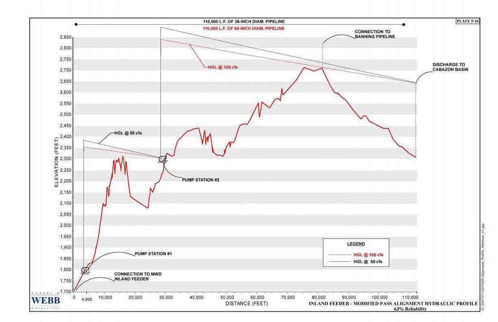
82
83
84 SECTION 6 - PROJECT COST ESTIMATES COST ESTIMATE CRITERIA For purposes of comparing the cost of alternative alignments, the cost criteria and methodology presented in the August 2007 Development Plan were used where applicable. The total cost for each alternative developed herein consists of the total project cost, and the present worth of annual operation (energy) and maintenance cost. The total project costs of the Lucerne and the North Pass Alignments are based on Table 7-3 of the August 2007 Development Plan, Cost Estimating Criteria (Appendix G). These two alignments proposed a 90-inch diameter pipeline and the cost criteria included the cost of all capital facilities, engineering and administration, pipeline right-of-way acquisition, environmental mitigation, etc. The project cost of these two alternatives was then adjusted to an Engineering News Record (ENR) Los Angeles Construction Cost Index of 9, (March 2009) 1. The same cost criterion was used to develop the project cost for the Independent SGPWA North Pass Alignment and the Inland Feeder Modified Pass Alignment. In addition to analyzing project costs for each alternative, a separate operations and maintenance cost analysis was performed which included energy cost to pump flows through each alternative alignment and maintenance cost for pipelines, pump stations, hydro stations, reservoirs, forebays, afterbays, etc. The annual power and operations and maintenance costs were developed using the cost basis presented in the August 2007 Development Plan (see Appendix G) and adjusted to present value based on an interest rate of 6 percent over 40 years per the August 2007 Development Plan. Lucerne Valley Alignment Cost Analysis The project cost estimate and operations and maintenance cost estimate for Lucerne Valley Alignment (Plate 5-3) was based on the criteria presented in the August 2007 Development Plan. However, the allocation of cost for each proposed participating agency was based on the percentage of each agency s allocated capacity (refer to Appendix H for details). Table 6-1 and Table 6-2 summarize the percentage of cost for each participating agency, based on allocated capacity in the Lucerne Valley Alignment and the North Pass Alignment based upon a SWP delivery reliability of 63% and 80%. 1 The ENR Los Angeles Construction Cost Index for July 2009 is 9, For planning purposes of this report, the March 2009 ENR Index was utilized. A L B E R T A. WEBB A S S O C I A T E S Page 6-1
85 Table 6-1: Allocated Capacity to CVWD, DWA, SGPWA and Morongo Tribal Lands for the Lucerne Valley and the North Pass Alignments (SWP 63% Reliability) Pipeline Size Total Capacity CVWD and Morongo SGPWA DWA Tribal Lands cfs % cfs % cfs % 90-inch Dia. 311 cfs inch Dia. 361 cfs inch Dia. 419 cfs Table 6-2: Allocated Capacity to CVWD, DWA, SGPWA and Morongo Tribal Lands for the Lucerne Valley and the North Pass Alignments (SWP 80% Reliability) Pipeline Size Total Capacity CVWD and Morongo SGPWA DWA Tribal Lands cfs % cfs % cfs % 90-inch Dia. 311 cfs inch Dia. 336 cfs inch Dia. 382 cfs Additionally, the project cost estimate and operations and maintenance costs for the Loop Pipeline (Plate 5-6) are included and costs will be allocated accordingly based on SGPWA and Morongo Tribal Lands allocated capacity (Table 6-3 and Table 6-4). Table 6-3: Allocated Capacity to SGPWA and Morongo Tribal Lands for the Loop Pipeline, Independent SGPWA North Pass Alignment and the Inland Feeder Modified Pass Alignment (SWP 63% Reliability) Pipeline Size Total Capacity Morongo SGPWA Tribal Lands cfs % cfs % 36-inch Dia. 50 cfs inch Dia. 108 cfs Table 6-4: Allocated Capacity to SGPWA and Morongo Tribal Lands for the Loop Pipeline Alignment, Independent SGPWA North Pass Alignment, and the Inland Feeder Modified Pass Alignment (SWP 80% Reliability) A L B E R T A. WEBB A S S O C I A T E S Page 6-2
86 Pipeline Size Total Capacity Morongo SGPWA Tribal Lands cfs % cfs % 30-inch Dia. 25 cfs inch Dia. 71 cfs The total cost for the Lucerne Valley Alignment, including the present worth of annual power and O&M costs (i=6%, n= 40 years and pwf= ) is summarized in Table 6-5 and Table 6-6 below. Table 6-5: Lucerne Valley Alignment Cost Summary (SWP 63% Reliability) Description CVWD & DWA (311 cfs) CVWD, DWA and SGPWA (361 cfs) CVWD, DWA, SGPWA & Morongo Tribal Lands (419 cfs) Total Project Cost (1) $1,083,700,000 $1,312,600,000 $1,488,000,000 Present Worth of Annual Power Cost (2)(3) $106,300,000 $205,100,000 $201,900,000 Present Worth of Annual O&M Cost (2)(4) $73,300,000 $82,400,000 $91,100,000 Total Cost $1,263,300,000 $1,600,100,000 $1,781,000,000 CVWD Cost (311 cfs) $1,263,300,000 $1,176,200,000 $1,071,500,000 SGPWA Cost (50 cfs) $0 $423,900,000 (5) $326,900,000 (5) Morongo Tribal Lands Cost (58 cfs) $0 $0 $382,600,000 (5) Total Cost $1,263,300,000 $1,600,100,000 $1,781,000,000 (1) See Appendix I for a detailed breakdown of project costs. (2) Present worth analysis for annual power and maintenance costs based on interest rate of 6%, duration of 40 years and pwf= (3) See Appendix J for a detailed breakdown of annual power costs. (4) See Appendix K for a detailed breakdown of annual maintenance costs. (5) Includes cost of Loop Pipeline. A L B E R T A. WEBB A S S O C I A T E S Page 6-3
87 Table 6-6: Lucerne Valley Alignment Cost Summary (SWP 80% Reliability) Description CVWD & DWA (311 cfs) CVWD, DWA and SGPWA (336 cfs) CVWD, DWA, SGPWA & Morongo Tribal Lands (382 cfs) Total Project Cost (1) $1,084,100,000 $1,261,700,000 $1,388,200,000 Present Worth of Annual Power Cost (2)(3) $106,300,000 $128,900,000 $181,300,000 Present Worth of Annual O&M Cost (2)(4) $73,300,000 $78,100,000 $85,700,000 Total Cost $1,263,700,000 $1,468,700,000 $1,655,200,000 CVWD Cost (311 cfs) $1,263,700,000 $1,225,400,000 $1,118,500,000 SGPWA Cost (25 cfs) $0 $243,300,000 (5) $188,900,000 (5) Morongo Tribal Lands Cost (46 cfs) $0 $0 $347,800,000 (5) Total Cost $1,263,700,000 $1,468,700,000 $1,655,200,000 (1) (2) (3) (4) (5) See Appendix L for a detailed breakdown of project costs. Present worth analysis for annual power and maintenance costs based on interest rate of 6%, duration of 40 years and pwf= See Appendix M for a detailed breakdown of annual power costs. See Appendix N for a detailed breakdown of annual maintenance costs. Includes cost of Loop Pipeline. North Pass Alignment Cost Analysis The project cost estimate and power and O&M costs for each participating agency for the North Pass Alignment alternative (Plate 5-9) are based on each agency s percentage of allocated capacity in the North Pass Alignment. Table 6-1 and Table 6-2 summarize the percentages and Table 6-7 and Table 6-8 summarize the associated costs for each agency based on allocated capacity. The cost to SGPWA and Morongo Tribal Lands for the North Pass Alignment terminates at the proposed Cabazon Basin Discharge Facilities as flows allocated to SGPWA and Morongo Tribal Lands will discharge at this point. Therefore, CVWD and DWA will be totally responsible for all facilities including pipelines, hydro stations, etc. for facilities beyond the Cabazon Basin Discharge Facilities. A L B E R T A. WEBB A S S O C I A T E S Page 6-4
88 Table 6-7: North Pass Alignment Cost Summary (SWP 63% Reliability) Description CVWD & DWA (311 cfs) CVWD, DWA and SGPWA (361 cfs) CVWD, DWA, SGPWA & Morongo Tribal Lands (419 cfs) Total Project Cost (1) $885,400,000 $926,700,000 $979,500,000 Present Worth of Annual Power Cost (2)(3) $113,000,000 $135,600,000 $141,100,000 Present Worth of Annual O&M Cost (2)(4) $58,900,000 $61,700,000 $63,300,000 Total Cost $1,057,300,000 $1,124,000,000 $1,183,900,000 CVWD Cost (311 cfs) $1,057,300,000 $1,018,300,000 $969,200,000 SGPWA Cost (50 cfs) $0 $105,700,000 $98,800,000 Morongo Tribal Lands Cost (58 cfs) $0 $0 $115,900,000 Total Cost $1,057,300,000 $1,124,000,000 $1,183,900,000 (1) See Appendix I for a detailed breakdown of project costs. (2) Present worth analysis for annual power and maintenance costs based on interest rate of 6%, duration of 40 years and pwf= (3) See Appendix J for a detailed breakdown of annual power costs. (4) See Appendix K for a detailed breakdown of annual maintenance costs. Table 6-8: North Pass Alignment Cost Summary (SWP 80% Reliability) Description CVWD & DWA (311 cfs) CVWD, DWA and SGPWA (336 cfs) CVWD, DWA, SGPWA & Morongo Tribal Lands (382 cfs) Total Project Cost (1) $885,400,000 $920,600,000 $953,200,000 Present Worth of Annual Power Cost (2)(3) $113,000,000 $111,000,000 $141,700,000 Present Worth of Annual O&M Cost (2)(4) $58,900,000 $60,700,000 $62,300,000 Total Cost $1,057,300,000 $1,092,300,000 $1,157,200,000 CVWD Cost (311 cfs) $1,057,300,000 $1,039,200,000 $1,006,300,000 SGPWA Cost (25 cfs) $0 $53,100,000 $53,700,000 Morongo Tribal Lands Cost (46 cfs) $0 $0 $97,200,000 Total Cost $1,057,300,000 $1,092,300,000 $1,157,200,000 (1) (2) (3) (4) See Appendix L for a detailed breakdown of project costs. Present worth analysis for annual power and maintenance costs based on interest rate of 6%, duration of 40 years and pwf= See Appendix M for a detailed breakdown of annual power costs. See Appendix N for a detailed breakdown of annual maintenance costs. A L B E R T A. WEBB A S S O C I A T E S Page 6-5
89 Independent SGPWA North Pass Alignment Cost Analysis The Independent SGPWA North Pass Alignment alternative (Plate 5-12) similarly parallels the North Pass Alignment. This alternative conveys water for SGPWA and Morongo Tribal Lands flows only as CVWD and DWA are not participants. Costs for the Independent SGPWA North Pass Alignment are based on the cost percentages as presented in Table 6-3 and Table 6-4. The total cost for the Independent SGPWA North Pass Alignment, including present worth of power and O&M costs (i=6%, n=40 years) is summarized in Table 6-9 and Table 6-10 below. Table 6-9: Independent SGPWA North Pass Alignment Cost Summary (SWP 63% Reliability) Description SGPWA (50 cfs) SGPWA & Morongo Tribal Lands (108 cfs) Total Project Cost (1) $181,700,000 $263,600,000 Present Worth of Annual Power Cost (2)(3) $75,900,000 $130,900,000 Present Worth of Annual O&M Cost (2)(4) $6,500,000 $9,600,000 Total Cost $264,100,000 $404,100,000 SGPWA Cost (50 cfs) $264,100,000 $185,900,000 Morongo Tribal Lands Cost (58 cfs) $0 $218,200,000 Total Cost $264,100,000 $404,100,000 (1) (2) (3) (4) See Appendix I for a detailed breakdown of project costs. Present worth analysis for annual power and maintenance costs based on interest rate of 6%, duration of 40 years and pwf= See Appendix J for a detailed breakdown of annual power costs. See Appendix K for a detailed breakdown of annual maintenance costs. A L B E R T A. WEBB A S S O C I A T E S Page 6-6
90 Table 6-10: Independent SGPWA North Pass Alignment Cost Summary (SWP 80% Reliability) Description SGPWA (25 cfs) SGPWA & Morongo Tribal Lands (71 cfs) Total Project Cost (1) $145,400,000 $228,900,000 Present Worth of Annual Power Cost (2)(3) $31,300,000 $80,600,000 Present Worth of Annual O&M Cost (2)(4) $3,900,000 $7,200,000 Total Cost $180,600,000 $316,700,000 SGPWA Cost (25 cfs) $180,600,000 $110,800,000 Morongo Tribal Lands Cost (46 cfs) $0 $205,900,000 Total Cost $180,600,000 $316,700,000 (1) See Appendix L for a detailed breakdown of project costs. (2) Present worth analysis for annual power and maintenance costs based on interest rate of 6%, duration of 40 years and pwf= (3) See Appendix M for a detailed breakdown of annual power costs. (4) See Appendix N for a detailed breakdown of annual maintenance costs. Inland Feeder Modified Pass Alignment Cost Analysis The Inland Feeder Modified Pass Alignment (Plate 5-15) assumes the partial utilization of 1000 cfs capacity in the MWD Inland Feeder pipeline to convey SWP water from the California Aqueduct to Mentone. The cost for the conveyance of flows through the MWD Inland Feeder is based on a percentage of the allocated capacity of the $1.2 billion project cost (per the August 2007 Development Plan). Table 6-11 and Table 6-12 summarize the cost percentage and the costs allocated to SGPWA and the Morongo Tribal Lands based on the allocated capacity in the Inland Feeder. Please note that power and O&M costs associated with the MWD Inland Feeder have yet to be analyzed. Once cost items related to MWD Inland Feeder are more defined, a more detailed analysis can be prepared and will be provided as a separate scope. Table 6-11: Cost Allocation of MWD Inland Feeder (SWP 63% Reliability) (1) Agency Flow Capacity (cfs) Percentage of Shared Cost Cost SGPWA % $60,000,000 Morongo Tribal Lands % $69,600,000 (1) Assumes MWD would sell capacity in the Inland Feeder for the price noted above. A L B E R T A. WEBB A S S O C I A T E S Page 6-7
91 Table 6-12: Cost Allocation of MWD Inland Feeder (SWP 80% Reliability) (1) Agency Flow Capacity (cfs) Percentage of Shared Cost Cost SGPWA % $30,000,000 Morongo Tribal Lands % $55,200,000 (1) Assumes MWD would sell capacity in the Inland Feeder for the price noted above. The Inland Feeder Modified Pass pipeline would be constructed from the proposed interconnection to the MWD Inland Feeder in the Mentone area to the SGPWA Service Area (Plate 5-15). The project cost and power and O&M costs of this alternative will be based on cost percentages presented in Table 6-3 and Table 6-4. The total cost for the Inland Feeder Modified Pass Alignment alternative, including the cost allocation for the MWD Inland Feeder pipeline, is summarized in Table 6-13 and Table 6-14 below. Table 6-13: Inland Feeder Modified Pass Alignment Cost Summary (SWP 63% Reliability) Description SGPWA (50 cfs) SGPWA & Morongo Tribal Lands (108 cfs) Total Project Cost (1) $176,200,000 $304,800,000 Present Worth of Annual Power Cost (2)(3) $66,400,000 $125,200,000 Present Worth of Annual O&M Cost (2)(4) $5,400,000 $8,300,000 Total Cost $248,000,000 $438,300,000 SGPWA Cost (50 cfs) $248,000,000 $201,600,000 Morongo Tribal Lands Cost (58 cfs) $0 $236,700,000 Total Cost $248,000,000 $438,300,000 (1) See Appendix I for a detailed breakdown of project costs. (2) Present worth analysis for annual power and maintenance costs based on interest rate of 6%, duration of 40 years and pwf= (3) Present worth of power cost through MWD Feeder Pipeline was not evaluated. See Appendix J for a detailed breakdown of annual power costs. (4) Present worth of maintenance cost through MWD Feeder Pipeline was not evaluated. See Appendix K for a detailed breakdown of annual maintenance costs. A L B E R T A. WEBB A S S O C I A T E S Page 6-8
92 Table 6-14: Inland Feeder Modified Pass Alignment Cost Summary (SWP 80% Reliability) Description SGPWA (25cfs) SGPWA & Morongo Tribal Lands (46 cfs) Total Project Cost (1) $119,900,000 $232,900,000 Present Worth of Annual Power Cost (2)(3) $30,400,000 $80,600,000 Present Worth of Annual O&M Cost (2)(4) $3,300,000 $6,300,000 Total Cost $153,600,000 $319,800,000 SGPWA Cost (25 cfs) $153,600,000 $111,100,000 Morongo Tribal Lands Cost (46 cfs) $0 $208,700,000 Total Cost $153,600,000 $319,800,000 (1) See Appendix L for a detailed breakdown of project costs. (2) Present worth analysis for annual power and maintenance costs based on interest rate of 6%, duration of 40 years and pwf= (3) Present worth of power cost through MWD Feeder Pipeline was not evaluated. See Appendix M for a detailed breakdown of annual power costs. (4) Present worth of maintenance cost through MWD Feeder Pipeline was not evaluated. See Appendix N for a detailed breakdown of annual maintenance costs. A L B E R T A. WEBB A S S O C I A T E S Page 6-9
93 SUMMARY OF TOTAL COSTS (1) Shown on Tables 6-15 and Table 6-16 are the allocated costs to SGPWA and Morongo Tribal Lands to convey the supplemental water demand via the four (4) alternatives discussed in this report. Table 6-15: Summary of Total Cost (SWP 63% Reliability) (1) Alternative Delivery of 311 cfs of SWP Water Delivery of 361 cfs of SWP Water Delivery of 419 cfs of SWP Water Lucerne Valley Alignment CVWD & DWA $1,263,300,000 $1,176,200,000 $1,071,500,000 SGPWA $0 $423,900,000 (2) $326,900,000 (2) Morongo Tribal Lands $0 $0 $382,600,000 (2) Total Cost $1,263, $1,600,100,000 $1,781,000,000 North Pass Alignment CVWD & DWA $1,057,300,000 $1,018,300,000 $969,200,000 SGPWA $0 $105,700,000 $98,800,000 Morongo Tribal Lands $0 $0 $115,900,000 Total Cost $1,057,300,000 $1,124,000,000 $1,183,900,000 Alternative Delivery of 311 cfs of SWP Water Delivery of 50 cfs of SWP Water Delivery of 108 cfs of SWP Water Independent SGPWA North Pass Alignment SGPWA $0 $264,100,000 $185,900,000 Morongo Tribal Lands $0 $0 $218,200,000 Total Cost $0 $264,100,000 $404,100,000 Inland Feeder Modified Pass Alignment SGPWA $0 $248,000,000 $201,600,000 Morongo Tribal Lands $0 $0 $236,400,000 Total Cost $0 $248,000,000 $438,300,000 (1) Total cost is the summation of project costs and present worth of power and maintenance costs. (2) Total cost includes cost for Lucerne Valley Alignment Loop Pipeline. A L B E R T A. WEBB A S S O C I A T E S Page 6-10
94 Table 6-16: Summary of Total Cost (SWP 80% Reliability) (1) Alternative Delivery of 311 cfs of SWP Water Delivery of 336 cfs of SWP Water Delivery of 382 cfs of SWP Water Lucerne Valley Alignment CVWD & DWA $1,263,700,000 $1,225,400,000 $1,118,500,000 SGPWA $0 $243,300,000 (2) $188,900,000 (2) Morongo Tribal Lands $0 $0 $347,800,000 (2) Total Cost $1,263,700,000 $1,468,700,000 $1,655,200,000 North Pass Alignment CVWD & DWA $1,057,300,000 $1,039,200,000 $1,006,300,000 SGPWA $0 $53,100,000 $53,700,000 Morongo Tribal Lands $0 $0 $97,200,000 Total Cost $1,057,300,000 $1,092,300,000 $1,157,200,000 Alternative Delivery of 311 cfs of SWP Water Delivery of 25 cfs of SWP Water Delivery of 71 cfs of SWP Water Independent SGPWA North Pass Alignment SGPWA $0 $180,600,000 $110,800,000 Morongo Tribal Lands $0 $0 $205,900,000 Total Cost $0 $180,600,000 $316,700,000 Inland Feeder Modified Pass Alignment SGPWA $0 $153,600,000 $111,100,000 Morongo Tribal Lands $0 $0 $208,700,000 Total Cost $0 $153,600,000 $319,800,000 (1) Total cost is the summation of project costs and present worth of power and maintenance costs. (2) Total cost includes cost for Lucerne Valley Alignment Loop Pipeline. A review of the alternative alignments shows that the North Pass Alignment results in the lowest cost ($105,700,000 for 63% reliability and $53,100,000 for 80% reliability) for SGPWA. If the Morongo Band of Mission Indians are a participant, this alternative will result in a SGPWA allocated cost of $98,800,000 and $53,700,000 for 63% and 80% reliability, respectively. A L B E R T A. WEBB A S S O C I A T E S Page 6-11
95 Of the stand-alone alternatives, the lowest total cost to SGPWA was the Inland Feeder Modified Pass Alignment ($248,000,000 for 63% reliability and $153,600,000 for 80% reliability). If the Morongo Band of Mission Indians is a participant, the Independent SGPWA North Pass Alignment results in the lowest total cost to SGPWA ($185,900,000 and $110,800,000) for 63% and 80% reliability respectively. COST ANALYSIS OF CHANGING PIPELINE VELOCITY The basis of cost estimates presented herein is directly related to maintaining a nominal pipeline velocity of 7 fps. An evaluation of increasing pipeline velocity to a nominal 8 fps was conducted to review the potential of decreasing project cost while possibly increasing O&M costs. For purposes of this study, the total cost of the North Pass Alignment at 8 fps (Appendix O) was compared to the total cost of the North Pass Alignment based on 7 fps (Table 6-7). The North Pass Alignment was used for this comparison as this alternative resulted in the lowest cost to SGPWA. It was determined that increasing the water velocity resulted in a lower pipeline size, therefore decreasing the total initial project cost by approximately $15.9 million ($9.2 million for SGPWA) (Table 6-17). However, the increase in velocity and increased friction losses in pipelines results in pump stations requiring upsizing and therefore increasing energy requirements to pump SWP water to SGPWA region. The increase in the present worth cost of energy and O&M was determined to be approximately $36.3 million ($0.5 million for SGPWA) (Table 6-17). Therefore, a total net increase of approximately $20.4 million for the North Pass Alternative is calculated should velocity increase to 8 fps, although SGPWA would benefit as the SGPWA cost portion would be reduced by $8.7 million. Overall, there are initial cost savings, though costs would increase for operations and maintenance of the facilities. Further cost analysis for all alternatives are recommended should SGPWA decide to increase velocity to 8 fps. A L B E R T A. WEBB A S S O C I A T E S Page 6-12
96 Table 6-17: Summary of Results of Cost Differential for 7 fps vs. 8 fps for North Pass Alignment (SWP 63% Reliability) Cost Portions of North Pass Alignment (1) Costs are based on i = 6% and n = 40 years, pwf= Pipeline Velocities Criteria 7 fps 8 fps Cost Differential Project Cost CVWD & DWA Portion $858,600,000 $851,900,000 -$6,700,000 SGPWA Portion $68,100,000 $58,900,000 -$9,200,000 Total Project Cost $926,700,000 $893,800,000 -$15,900,000 Energy Cost (1) CVWD & DWA Portion $100,400,000 $135,600,000 $35,200,000 SGPWA Portion $35,200,000 $35,600,000 $400,000 Total Energy Cost (1) $135,600,000 $162,900,000 $35,600,000 Maintenance Cost (1) CVWD & DWA Portion $59,300,000 $59,900,000 $600,000 SGPWA Portion $2,400,000 $2,500,000 $100,000 Total Maintenance Cost (1) $61,700,000 $62,400,000 $700,000 Total Cost CVWD & DWA Portion $1,018,300,000 $1,047,400,000 $29,100,000 SGPWA Portion $105,700,000 $97,000,000 -$8,700,000 Total Cost $1,124,000,000 $1,144,400,000 $20,400,000 CONTINGENCIES COST ANALYSIS The proposed alternatives are presently considered to be in the conceptual stages of development. Therefore, due to the extent of information available and method of preparation, an accuracy range of +30% to -10% was utilized to determine the project cost of the alternatives studied herein (Table 6-18 to 6-25) 13. As these projects develop further and more details are defined, the accuracy of the project cost is expected to improve. 13 The contingency cost analysis was based upon the August 2007 Development Plan. A L B E R T A. WEBB A S S O C I A T E S Page 6-13
97 Table 6-18: SGPWA and Morongo Tribal Lands Project Cost Contingencies for Lucerne Valley Alignment Upsizing and Loop Pipeline for 63% Reliability Alternative 1 Accuracy Range: Lucerne Valley Alignment Upsizing Alternative 1-A (SGPWA Cost Participating with CVWD & DWA 50 cfs) Alternative 1-B (SGPWA Cost Participating with CVWD,DWA & Morongo 50 cfs) Alternative 1-C (Morongo Cost Participating with SGPWA,CVWD & DWA 58 cfs) -10% - 30% -10% - 30% -10% - 30% $272,100,000 $302,300,000 $393,000,000 $216,300,000 $240,300,000 $312,400,000 $252,900,000 $281,000,000 $365,300,000 Table 6-19: SGPWA and Morongo Tribal Lands Project Cost Contingencies for North Pass Alignment Upsizing for 63% Reliability Alternative 2 Accuracy Range: Independent North Pass Alignment Alternative 2-A (SGPWA Cost Participating with CVWD & DWA 50 cfs) Alternative 2-B (SGPWA Cost Participating with CVWD,DWA & Morongo 50 cfs) Alternative 2-C (Morongo Cost Participating with SGPWA,CVWD & DWA 58 cfs) -10% - 30% -10% - 30% -10% - 30% $61,300,000 $68,100,000 $88,500,000 $57,400,000 $63,800,000 $82,900,000 $67,500,000 $75,000,000 $97,500,000 Table 6-20: SGPWA and Morongo Tribal Lands Project Cost Contingencies for Independent SGPWA North Pass Alignment for 63% Reliability Alternative 3 Accuracy Range: Independent North Pass Alignment Alternative 3-A (SGPWA alone 50 cfs) Alternative 3-B (SGPWA Cost Participating with Morongo 50 cfs) Alternative 3-C (Morongo Cost Participating with SGPWA 58 cfs) -10% - 30% -10% - 30% -10% - 30% $163,500,000 $181,700,000 $236,200,000 $109,200,000 $121,300,000 $157,700,000 $128,100,000 $142,300,000 $185,000,000 Table 6-21: SGPWA and Morongo Tribal Lands Project Cost Contingencies for Inland Feeder Modified Pass Alignment for 63% Reliability Alternative 4 Accuracy Range: Inland Feeder Modified Pass Alignment Alternative 4-A (SGPWA alone 50 cfs) Alternative 4-B (SGPWA Cost Participating with Morongo 50 cfs) Alternative 4-C (Morongo Cost Participating with SGPWA 58 cfs) -10% - 30% -10% - 30% -10% - 30% $158,600,000 $176,200,000 $229,100,000 $126,200,000 $140,200,000 $182,300,000 $148,100,000 $164,600,000 $214,000,000 A L B E R T A. WEBB A S S O C I A T E S Page 6-14
98 Table 6-22: SGPWA and Morongo Tribal Lands Project Cost Contingencies for Lucerne Valley Alignment Upsizing and Loop Pipeline for 80% Reliability Alternative 1 Accuracy Range: Lucerne Valley Alignment Upsizing Alternative 1-A (SGPWA Cost Participating with CVWD & DWA 25 cfs) Alternative 1-B (SGPWA Cost Participating with CVWD,DWA & Morongo 25 cfs) Alternative 1-C (Morongo Cost Participating with SGPWA,CVWD & DWA 46 cfs) -10% - 30% -10% - 30% -10% - 30% $170,200,000 $189,100,000 $245,800,000 $125,700,000 $139,700,000 $181,600,000 $222,400,000 $247,100,000 $321,200,000 Table 6-23: SGPWA and Morongo Tribal Lands Project Cost Contingencies for North Pass Alignment Upsizing for 80% Reliability Alternative 2 Accuracy Range: Independent North Pass Alignment Alternative 2-A (SGPWA Cost Participating with CVWD & DWA 25 cfs) Alternative 2-B (SGPWA Cost Participating with CVWD,DWA & Morongo 25 cfs) Alternative 2-C (Morongo Cost Participating with SGPWA,CVWD & DWA 46 cfs) -10% - 30% -10% - 30% -10% - 30% $32,300,000 $35,900,000 $46,700,000 $31,000,000 $34,400,000 $44,700,000 $57,400,000 $63,800,000 $82,900,000 Table 6-24: SGPWA and Morongo Tribal Lands Project Cost Contingencies for Independent SGPWA North Pass Alignment for 80% Reliability Alternative 3 Accuracy Range: Independent North Pass Alignment Alternative 3-A (SGPWA alone 25 cfs) Alternative 3-B (SGPWA Cost Participating with Morongo 25 cfs) Alternative 3-C (Morongo Cost Participating with SGPWA 46 cfs) -10% - 30% -10% - 30% -10% - 30% $130,900,000 $145,400,000 $189,000,000 $72,100,000 $80,100,000 $104,100,000 $133,900,000 $148,800,000 $193,400,000 Table 6-25: SGPWA and Morongo Tribal Lands Project Cost Contingencies for Inland Feeder Modified Pass Alignment for 80% Reliability Alternative 4 Accuracy Range Inland Feeder Modified Pass Alignment Alternative 4-A (SGPWA alone 25 cfs) Alternative 4-B (SGPWA Cost Participating with Morongo 25 cfs) Alternative 4-C (Morongo Cost Participating with SGPWA 46 cfs) -10% - 30% -10% - 30% -10% - 30% $107,900,000 $119,900,000 $155,900,000 $73,400,000 $81,500,000 $106,000,000 $136,300,000 $151,400,000 $196,800,000 A L B E R T A. WEBB A S S O C I A T E S Page 6-15
99 SECTION 7 - FINDINGS, CONCLUSIONS AND RECOMMENDATIONS Study Area FINDINGS The San Gorgonio Pass area is the narrow east-west strip of land (generally mountainous) between the San Bernardino Valley to the west and the Palm Springs/Coachella Valley to the east. San Gorgonio Pass Water Agency (SGPWA) is located within this area and within its boundaries lie the Cities of Calimesa, Beaumont, Banning and portions of unincorporated Riverside County and San Bernardino County. SGPWA provides water to the retailers within its boundaries. The following are major water retailers: Beaumont Cherry Valley Water District (BCVWD) City of Banning Water Department Yucaipa Valley Water District (YVWD) Cabazon Water District (CWD) Banning Heights Mutual Water Company (BHMWC) High Valleys Water District (HVWD) South Mesa Water Company (SMWC) Morongo Band of Mission Indians Shown in Table 2-7 is the total acreage of SGPWA s service area (142,416 acres) and the acreage of each water retailer, Morongo Tribal Lands, and the balance of the unincorporated areas of Riverside and San Bernardino Counties. Ultimate Demand Projections The ultimate water demand projections were based on utilizing the Cities and Counties general plan and land use in conjunction with water demand factors (see Table 2-5 for a summary of the water demand factors applied to general plan land use). Tribal lands general plan land use was not available; therefore a slope analysis (see Table 2-6 for Tribal lands slope analysis) was conducted to review potentially buildable areas (areas with slopes 10% and less) and an assumed unit use factor of 2 acre-feet/acre/year was applied to these areas. Ultimate water demand was evaluated by applying the general plan land use within each water retailer s service areas as summarized in Table 7-1. Table 7-2 summarizes the potential ultimate water demand for the San Gorgonio Pass Water Agency service area. A L B E R T A. WEBB A S S O C I A T E S Page 7-1
100 Table 7-1: Ultimate Water Demand for Major Water Retailers, Unincorporated County and Morongo Tribal Lands Water Retailer Total Area (Acres) Demand (Ac-Ft/Yr) (1) Water Retailers 71,852 92,878 Unincorporated Areas 35,953 1,420 SUBTOTAL for Unincorporated Areas & Water Retailers 107,805 94,298 Morongo Tribal Lands 34,611 38,627 TOTAL SGPWA Area 142, ,925 (1) Refer to Appendix C and Table 2-8 for detailed breakdown of demands within each water retailer. (2) Included unincorporated areas of Riverside and San Bernardino Counties within the SGPWA Service Area. (3) These areas are undesignated areas within Cities boundaries such as highways, and does not typically have demand Table 7-2: Potential Ultimate Water Demand for the San Gorgonio Pass Water Agency Service Area (1) (2) Demand Demand Criteria (Ac-Ft/Yr) (1) SGPWA 94,000 Morongo Tribal Lands 39,000 (2) SGPWA and Morongo Tribal Lands 133,000 Rounded to nearest thousand. Subsequent to this the Morongo Band of Mission Indians indicated that the SGPWA should assume that they would need only 20,000 acre-feet of State Water Project water. Total Local Water Supply for SGPWA The total local water supply for the SGPWA service area is based on the supplies per each of the various major water retailers, allocated available supply of Beaumont Groundwater Basin and new returns from use to groundwater. Table 3-5 summarizes local water supply for the SGPWA service area projected for the year Therefore the total local water supply is approximately 55,000. It is noted that the local water supply data was derived from an existing report and a critical analysis needs to be undertaken to determine the accuracy of the availability of the projected local water supply. Additionally, as discussed in Section 4 of this report, a representative of the Morongo Band of Mission Indians indicated that the Morongo Tribal Lands may need up to 20,000 acre-feet of State Water Project water rather than the 39,000 acre-feet per year noted above. Total local water supply was deducted from ultimate water demand to determine the supplemental State Water Project water required by SGPWA and Morongo Tribal Lands (summarized in Table 7-3). A L B E R T A. WEBB A S S O C I A T E S Page 7-2
101 Table 7-3: Supplemental SWP Water Requirements Service Area Demand (1) (Ac-Ft/Yr) SGPWA 39,000 (2) Morongo Tribal Lands 20,000 SGPWA and Morongo Tribal Lands 59,000 (1) (2) Rounded to nearest thousand. Local water supply deducted from SGPWA water retailers. As discussed in Section 3 of this report, the estimate of local water supply utilized in this report was based on the May 2006, Report on Water Supply Conditions in the San Gorgonio Pass Region prepared by Wildermuth Environmental. There is a potential that the local water supply may be over estimated hence this would lead us to under estimate the supplemental water required by SGPWA in the future. For the purposes of this report, we utilized the local water supply data from the Wildermuth Environmental report, but are not in agreement with the findings. Reliability and Delivery Requirements The Department of Water Resources final The State Water Project Reliability Project 2007 August 2008 indicates a long term average reliability for delivery of State Water Project Water of 63 percent. There is a potential for the Sacramento Delta to be fixed, therefore we assumed that the long term overall reliability of State Water Project delivery would increase to 80 percent. Table 7-4 summarizes the projected Table A water required (refer to Appendix D for details) with consideration given to long term average reliability of SWP water utilizing both reliability factors mentioned above. A L B E R T A. WEBB A S S O C I A T E S Page 7-3
102 Table 7-4: Projected San Gorgonio Pass Water Agency Table A Water Requirements (1) Service Area Demand (Acre-feet/year) (2) 63% Reliability 80% Reliability SGPWA 62,000 49,000 Morongo Tribal Lands 32,000 25,000 SGPWA and Morongo Tribal Lands (3) 94,000 74,000 (1) (2) Includes SGPWA Table A entitlements. Rounded to the nearest thousand DWR allows peak delivery of SWP water during wet years, therefore the conveyance facilities are sized to deliver peak flows. Peaking criteria is based on delivery of 100% of Table A supply in nine (9) months and is converted to cubic feet per second (cfs). Table 7-5 (see Appendix D for details) summarizes these flow scenarios. Table 7-5: Projected San Gorgonio Pass Water Agency Table A Water Capacity Service Area Capacity (cfs) 63% Reliability 80% Reliability SGPWA Morongo Tribal Lands SGPWA and Morongo Tribal Lands Current and Future Capacities Owned by SGPWA SGPWA s capacities in the East Branch Extension are summarized in Table 7-6. Table 7-6: SGPWA Current and Projected Capacity in State Water Project Description Delivery Capacities (cfs) (1) (2) Phase I EBX (Current capacity) 24 cfs Phase II EBX (1) (Projected capacity in 2013) 48 cfs Additional EBX Capacity (2) (From SBVMWD) 16 cfs Total SWP Water Capacity 64 cfs Department of Water Resources East Branch Extension Phase II facilities are scheduled to be completed in 2012, although per July 2009 discussions with SGPWA Agency Representative, completion is scheduled in As per a July 30, 2008 correspondence and an August 13, 2008 meeting with the SGPWA Agency representative, SGPWA indicated there will be potential negotiations with San Bernardino Valley Municipal Water District for additional EBX capacity. A L B E R T A. WEBB A S S O C I A T E S Page 7-4
103 The SGPWA delivery capacity in EXB Phase II (48 cfs) and acquisition of an additional 16 cfs capacity was deducted from SGPWA projected capacity values shown in Table 7-5. The resulting capacities were utilized for evaluation of new importation facilities required to convey the balance of SGPWA projected demand. Table 7-7 summarizes the new facilities delivery requirements to deliver Supplemental SGPWA Water (refer to Appendix E for details). Table 7-7: SGPWA Supplemental Delivery Requirements in a Future Importation Project Study Area Capacity (cfs) 63% Reliability 80% Reliability SGPWA Morongo Tribal Lands (1) SGPWA and Morongo Tribal Lands (1) SGPWA owned and future delivery capacities not deducted from Morongo Tribal Lands delivery requirements. Delivery Facilities SGPWA, anticipating the need for supplemental water, reviewed the CVWD and DWA State Water Project Aqueduct Extension (SWP Aqueduct Extension) Study (August 2007 Development Plan) for possible usage of the following alternative alignments: Lucerne Valley Alignment North Pass Alignment South Pass Alignment San Jacinto Alignment The South Pass and San Jacinto Alignments were omitted due to minimal capacity rights in the Santa Ana Valley Pipeline (SAVP). Two additional alignments were evaluated for potential delivery of supplemental water independent from SWP Aqueduct Extension: Independent SGPWA North Pass Alignment Inland Feeder Modified Pass Alignment Therefore the alignments evaluated for delivery of SGPWA supplemental water are as follows: 1. Lucerne Valley Alignment 2. North Pass Alignment 3. Independent SGPWA North Pass Alignment 4. Inland Feeder Modified Pass Alignment A L B E R T A. WEBB A S S O C I A T E S Page 7-5
104 As with water delivery capacities, the delivery requirements were also evaluated with two reliability factors (63 percent and 80 percent) of SWP Project Water deliveries. Alternatives 1 and 2 noted above require joint participation with CVWD and DWA and the delivery requirements for these two entities was fixed at 311 cfs. Evaluation of the Alvernatives 3 and 4 does not include conveyance capacity for CVWD and DWA. For evaluation purposes, the following pipeline, pumping and hydraulic parameters were utilized: Pipeline Velocity: 7 fps Pressure Limitations: 250 psi Discharge point: Cabazon Basin Evaluation of existing topography versus hydraulic grade line Pumping Power Requirements Piping system characteristic such as length, diameter and friction Power calculation in horsepower and kilowatts The power requirement for each pump station was evaluated based on the above parameters. The characteristics of these facilities are detailed and summarized in Table 5-4 through Table 5-14 and are designated based on the respective reliability factors. Table 7-8 through Table 7-11 summarize the facilities of each of the four alternatives. Table 7-8: Facilities Parameters for Lucerne Valley Alignment (Plates 5-3 to 5-8) Facility Description Pipeline Length and Sizing 480,480 feet of pipeline ranging in diameters from 96-inch to 108-inch 99,200 feet of pipeline ranging in diameters from 30-inch to 54-inch (Loop Pipeline) Pump Stations Two (2) large pump stations ranging from 23,000 hp to 30,000 hp each Three (3) small pump stations ranging from 1,600 hp to 4,000 hp (Loop Pipeline) Hydro-Electric Power Plants Four (4) Hydro-Electric Power Plants ranging from 20,000 hp to 30,000 hp each A L B E R T A. WEBB A S S O C I A T E S Page 7-6
105 Table 7-9: Facilities Parameters for North Pass Alignment (Plates 5-9 to 5-11) Facility Description Pipeline Length and Sizing 190,000 feet of pipeline ranging in diameter from 96-inch to 102-inch 2,000 feet of pipeline ranging in diameter from 30-inch to 54-inch (Turnout for Cabazon Recharge Basin) 132,000 feet of 90-inch diameter pipeline (second reach, not utilized by SGPWA) 34,320 feet of 42-inch diameter pipeline (Turnout for Reach along Highway 62, not utilized by SGPWA) Pump Stations Two (2) pump stations ranging from 21,000 hp to 28,000 hp each Hydro-Electric Power Plants Three (3) Hydro-Electric Power Plants ranging from 12,000 hp to 18,000 hp each (not utilized by SGPWA) Table 7-10: Facilities Parameters for Independent North Pass Alignment (Plates 5-12 to 5-14) Facility Description Pipeline Length and Sizing 192,200 feet of pipeline ranging in diameters from 30-inch to 54-inch Pump Stations Two (2) pump stations ranging from 2,000 hp to 9,000 hp each Table 7-11: Facilities Parameters for Inland Feeder Modified Pass Alignment (Plates 5-15 to 5-17) Facility Description Pipeline Length and Sizing 100,000 feet of pipeline ranging in diameters from 30-inch to 54-inch Pump Stations Two (2) pump stations ranging from 2,000 hp to 9,000 hp each A L B E R T A. WEBB A S S O C I A T E S Page 7-7
106 Cost Evaluation The cost evaluation of alternative alignments was based on the cost criteria and methodology presented in the August 2007 Development Plan prepared by GEI/Bookman-Edmonston. The total cost for each alternative developed herein consists of the total project cost, and the present worth of annual operation (energy) and maintenance cost. The project cost of these alternatives was then adjusted to an Engineering News Record (ENR) Los Angeles Construction Cost Index 9, (March 2009) 14. The allocation of cost for each proposed participating agency was based on the percentage of each agency s allocated capacity. Table 6-1 and Table 6-2 summarize the percentage of cost for each participating agency, based on allocated capacity at 63% and 80% reliability when all parties participate. When reviewing only SGPWA and Morongo Tribal Lands allocated capacity, refer to Table 6-3 and Table 6-4. The Inland Feeder Modified Pass Alignment cost evaluation included SGPWA purchasing a portion of the 1000 cfs capacity of the MWD Inland Feeder pipeline. Table 6-11 and 6-12 summarize these costs for SGPWA and Morongo Tribal Lands. Parameters such as pipeline size and length, pump station power requirements, power cost, operation and maintenance cost were evaluated in conjunction with cost allocations for various agencies to develop project costs associated with each alignment alternative. Tables 6-15 and 6-16 summarize the total cost (project cost and present worth of maintenance and energy) allocated to each participating agency, including CVWD and DWA. Table 7-12 and Table 7-13 summarize the allocated total cost for SGPWA and Morongo Tribal Lands to convey the supplemental water based on the four (4) alternatives presented in this report. 14 The ENR-Los Angeles Construction Cost Index for July 2009 is 9, For planning purposes of this report, the March 2009 ENR Index was utilized. A L B E R T A. WEBB A S S O C I A T E S Page 7-8
107 Table 7-12: Summary of Total Cost Allocated to SGPWA and Morongo Tribal Lands SWP 63% Reliability (1) Alternative Alignments Delivery of SWP Water for SGPWA Delivery of SWP Water for SGPWA and Morongo Tribal Lands Lucerne ValleyAlignment SGPWA $423,900,000 (2) $326,900,000 (2) Morongo Tribal Lands - $382,600,000 (2) Total Cost $423,900,000 $709,500,000 North Pass Alignment SGPWA $105,700,000 $98,800,000 Morongo Tribal Lands - $115,900,000 Total Cost $105,700,000 $214,700,000 Independent SGPWA North Pass Alignment SGPWA $264,100,000 $185,900,000 Morongo Tribal Lands - $218,200,000 Total Cost $264,100,000 $404,100,000 Inland Feeder Modified Pass Alignment SGPWA $248,000,000 $201,600,000 Morongo Tribal Lands - $236,700,000 Total Cost $248,000,000 $438,300,000 (1) Total cost is the summation of project costs and present worth of power and maintenance costs. (2) Total cost includes cost for Lucerne Valley Alignment Loop Pipeline. A L B E R T A. WEBB A S S O C I A T E S Page 7-9
108 Table 7-13: Summary of Total Cost Allocated to SGPWA and Morongo Tribal Lands SWP 80% Reliability (1) Alternative Alignments Delivery of SWP Water for SGPWA Delivery of SWP Water for SGPWA and Morongo Tribal Lands Lucerne Valley Alignment SGPWA $243,300,000 (2) $188,900,000 (2) Morongo Tribal Lands - $347,800,000 (2) Total Cost $243,300,000 $536,700,000 North Pass Alignment SGPWA $53,100,000 $53,700,000 Morongo Tribal Lands - $97,200,000 Total Cost $53,100,000 $150,900,000 Independent SGPWA North Pass Alignment SGPWA $180,600,000 $110,800,000 (1) (2) Morongo Tribal Lands - $205,900,000 Total Cost $180,600,000 $316,700,000 Inland Feeder Modified Pass Alignment SGPWA $153,600,000 $111,100,000 Morongo Tribal Lands - $208,700,000 Total Cost $153,600,000 $319,800,000 Total cost is the summation of capital costs and present worth of power and maintenance costs. Total cost includes cost for Lucerne Valley Alignment Loop Pipeline. Project Phasing and Implementation Project phasing and implementation was evaluated for SGPWA only, as incremental water demand projections for Morongo Tribal Lands were not available. SGPWA has experienced significant population growth in its service area. Incremental population growth in conjunction with corresponding water demand was evaluated from 2000 to 2035 and summarized in Table 2-2 and Table 2-3. Based on these methodologies, the projected water demand for 2035 ranged from 60,821 acre-feet/year to 89,552 acre-feet/year depending on the water unit use factor utilized. Review of the various local water retailer s Urban Water Management Plans provided for an additional methodology for projecting demand. A L B E R T A. WEBB A S S O C I A T E S Page 7-10
109 Based on this UWMP methodology, the projected water demand for the year 2030 is 88,600 acrefeet/year. The potential ultimate water demand for the SGPWA service area (excluding Morongo Tribal Lands) was projected to be 94,000 acre-feet/year based on buildout conditions. Using the demand trend assumptions from 2005 to 2035, it was projected that ultimate buildout demand would occur around year Based on these various parameters, the SGPWA Incremental Supplemental SWP Water was evaluated and presented in Section 4 in Table 4-3 and Figure 4-1 of this report. The discussions in Section 4 and summaries presented in Table 4-3 and Figure 4-1 provides for the SGPWA Supplemental SWP water demand as the Agency s service area demand increases above the local water supply. Evaluation of incremental delivery requirements requires incorporation of various analysis criteria previously developed in this report: Department of Water Resources Reliability Factors Allowable Peak 9 Month Delivery During Wet Years The Agency s Owned and Future State Water Project Capacities. Reliability factors of 63 and 80 percent of State Water Project water, as well as allowable peaking factors, were applied incrementally to the Supplemental SWP water requirements. The SGPWA owned and future SWP capacity was assumed in phases and was deducted from Supplemental SWP requirements to determine the incremental delivery requirements presented in Table 7-14 and Figure 7-1 and 7-2. A L B E R T A. WEBB A S S O C I A T E S Page 7-11
110 Table 7-14: SGPWA Supplemental Delivery Requirements Phased to Ultimate Buildout in Year 2045 Year Table A Water Capacity SGPWA Supplemental SGPWA Delivery Requirements (cfs) SWP Water Requirements (cfs) 63% Reliability 80% Reliability Capacity (cfs) 63% Reliability 80% Reliability (1) (2) (3) (1) (2) (3) Current SGPWA delivery capacity of 24 cfs in East Branch Existing Phase I. As per July 2009 discussions with SGPWA Agency Representative, East Branch Extension Phase II is scheduled to be completed by This would increase SGPWA delivery capacity to 48 cfs. Potential purchase of 16 cfs of SWP water from SBVMWD A L B E R T A. WEBB A S S O C I A T E S Page 7-12
111 120 Figure 7-1: SGPWA Projected Supplement Delivery Requirements (SWP 63% Reliability) 100 EBX Phase I EBX Phase II Acquisition of 16 cfs Table "A" Requirements at 63% Supplemental Delivery Requirements at 63% 80 Capacity (cfs) 60 Potential Acquisition of 16 cfs from SBVMWD [64 cfs Total] Completion of EBX Phase II [48 cfs Total] 40 Current SGPWA EBX Capacity [24 cfs Total] 20 0 Year Year G:\2007\ \Report\Projection Analysis (SGPWA).xls Fig 7 1
112 100 Figure 7-2: SGPWA Projected Supplement Delivery Requirements (SWP 80% Reliability) Capacity (cfs) EBX Phase I EBX Phase II Acquisition of 16 cfs Table "A" Requirements at 80% Supplemental Delivery Requirements at 80% Potential Acquisition of 16 cfs from SBVMWD [64 cfs Total] Completion of EBX Phase II [48 cfs Total] 30 Current SGPWA EBX Capacity [24 cfs Total] Year Year G:\2007\ \Report\Projection Analysis (SGPWA).xls Fig 7 2
113 As indicated in Figure 7-1 and 7-2, the SGPWA s Table A requirements for both 63% and 80% reliability exceed their total (owned and future) SWP Water. The approximate time frame for implementation of supplemental water delivery facilities is presented in Table Table 7-15: Implementation Date of SGPWA Supplemental Future Delivery Facilities Supplemental SGPWA Delivery Requirements (cfs) SGPWA Implementation of Facilities Date (year) 63% Reliability % Reliability 2027 CONCLUSIONS Based on findings, the ultimate water demand within the SGPWA service area exceeds the capacity of the local water supply and SGPWA s present and future capacity in the East Branch Extension. Cost Evaluations Based on the cost analysis of the four alternatives studied herein, the North Pass Alignment Alternative is the lowest cost option for SGPWA with the participation of CVWD and DWA. If SGPWA prefers to independently develop their own project, the Independent SGPWA North Pass Alternative is the lowest cost alternative, provided the Morongo Band of Mission Indians participate in the project. The cost savings when utilizing a reliability factor of 80% rather than 63% of SWP delivery is approximately a 50% to 60% decrease in cost. The 80% reliability factor for State Water Project water delivery was assumed based on a probable Delta fix. The timing of this Delta fix is unknown. Table 7-16 summarizes these costs. North Pass Table 7-16: Summary of Lowest Project Cost Alternatives to SGPWA (1) Alternative Alignment Participation Requirements CVWD and DWA SGPWA Project Costs 63% Reliability of SWP Water 80% Reliability of SWP Water $68,100,000 $35,900,000 Independent SGPWA North Pass None $181,700,000 $145,400,000 Inland Feeder Modified Pass (1) (2) (2) $176,200,000 $119,900,000 This project cost summary is based on consideration of SGPWA capacities only and does not include Morongo capacities. SGPWA allocated project cost for the Inland Feeder Modified Pass Alignment Alternative is lower than the cost for Independent SGPWA North Pass Alignment Alternative. However this alignment requires participation in the form of capacity purchase from MWD s Inland Feeder as discussed in Section 6 and therefore is not totally independent. A L B E R T A. WEBB A S S O C I A T E S Page 7-15
114 In addition to costs summarized in Table 7-16 above, other costs need to be taken into consideration to convey water to proposed recharge basins in the Beaumont and Cabazon Groundwater Basins. These improvements consist of the Beaumont Basin Site 4 Recharge Facility, and the Cabazon Basin Recharge Facility located on property currently owned by Robertson Ready Mix. These improvements require $18 million (Appendix P) in addition to the costs outlined in Table 7-16 Implementation Based on probable growth trends within the SGPWA service area, it would appear that the initial phases of the supplemental SWP water delivery system is required to be on-line within a 15 to 20 year period depending on which Sacramento Delta reliability factor is utilized. Current growth trends have decreased as a result of the current economic decline beginning in If the depressed economic conditions continue it may delay the need for the State Water Project Aqueduct Extension. RECOMMENDATIONS We recommend the following based on the study herein: 1. Continue working with Coachella Valley Water District and Desert Water Agency on the planning of the proposed State Water Project Aqueduct Extension Project. 2. Initiate a financial plan to determine SGPWA s means and methods of financial participation in the Aqueduct Extension Project and the acquisition of additional water rights. 3. Initiate action to acquire water rights to obtain 100 percent reliability of State Water Project water deliveries, or other water supplies. 4. Determine if the Morongo Band of Mission Indians intends to participate in the State Water Project Aqueduct Extension Project. 5. Evaluate the reliability of the local water supply within SGPWA s service area. 6. Initiate actions to acquire 16 cfs capacity in the East Branch Extension from SBVMWD. 7. Develop a conjunctive use plan to store and recover State Water Project water in the Beaumont, Cabazon, and other groundwater basins within SGPWA s service area. A L B E R T A. WEBB A S S O C I A T E S Page 7-16
115 APPENDIX A County and Cities Land Use Designation within the SGPWA Boundaries A L B E R T A. WEBB A S S O C I A T E S
116 Table A-1 San Gorgonio Pass Water Agency County of Riverside Land Use Designation and Respective Areas (Acres) County Lands (excluding Tribal Lands): Morongo Tribal Lands: LANDUSE ACRES LANDUSE ACRES AG 2,214.6 AG 53.0 CO 4.1 OS C CR OS RUR 45.4 CR CCO 75.2 RD 4.0 CT 15.6 RM 1,656.4 EDR RC RR HDR 8.6 IND 31,450.7 HI CCO 10.0 Other IND 24.7 Total 34,610.9 LDR LDR CCO LDR RC LI 26.9 LI CCO Riverside County: 105,408.9 MDR MDR CCO Morongo Tribal Lands: 34,610.9 MHDR 35.7 OS C 14,316.3 Riverside County Only: 70,798.0 OS CH 9,261.8 OS R 1,535.3 OS RUR 6,104.3 OS W 48.2 PF 84.8 RD 2,313.3 RD CCO RM 21,149.7 RR 4,189.4 RR CCO RR CD VLDR VLDR CCO VLDR RC 3,747.0 Other Total 70,798.0 XXX-CD is with a Community Development Overlay XXX-CCO is with a Community Center Overlay G:\2007\ \GIS\Tables\SGPWA_LU_County.xlsx, 8/14/09
117 Table A-2 San Gorgonio Pass Water Agency City of Calimesa Land Use Designation and Respective Areas (Acres) LANDUSE ACRES Business Park 78.7 Commercial Community Commercial Neighborhood Commercial Regional Light Industrial 34.9 Open Space 1,791.9 Open Space Residential 1,581.2 Professional Office 32.1 Quasi Public Residential Estate Residential High Residential Low 1,362.8 Residential Low/Medium 1,248.7 Residential Medium Residential Rural Residential Rural (2 ac. min.) 24.0 Utility Easement Other/Not Designated Grand Total 9,533.0 G:\2007\ \GIS\Tables\SGPWA_LU_Calimesa.xlsx, 8/14/09
118 Table A-3 San Gorgonio Pass Water Agency City of Beaumont Land Use Designation and Respective Areas (Acres) LANDUSE ACRES Beaumont Avenue Overlay 67.6 Community Commercial General Commercial Industrial Multiple family Residential Public Facilities 26.7 Recreation & Conservation 1,024.5 Rural Residential Single Family Residential 5,406.6 Urban Village Overlay Other/Not Designated 1,584.6 Grand Total 10,996.2 G:\2007\ \GIS\Tables\SGPWA_LU_Beaumont.xlsx, 8/14/09
119 Table A-4 San Gorgonio Pass Water Agency City of Banning Land Use Designation and Respective Areas (Acres) City of Banning (Excluding Tribal Lands) Morongo Tribal Lands Inside City Limits LANDUSE ACRES LANDUSE ACRES Airport Industrial General Commercial 19.7 Business Park High Density Residential (11 18 du/ac) 55.5 Downtown Commercial 97.4 Low Density Residential (0 5 du/ac) 70.1 General Commercial Medium Density Residential (0 10 du/ac) 41.3 High Density Residential (11 18 du/ac) Open Space Resources 88.5 Highway Serving Commercial Grand Total Industrial Industrial Mineral Resources Low Density Residential (0 5 du/ac) 3,079.9 Medium Density Residential (0 10 du/ac) Mobile Home Parks Open Space Parks 1,227.2 City of Banning 14,842.9 Open Space Resources 2,697.8 Morongo Tribal Lands Professional Office 41.6 City outside Tribal Lands 14,567.8 Public Facilities Airport Public Facilities Cemetery 15.4 Public Facilities Fire Station 3.6 Public Facilities Government 64.1 Public Facilities Hospital 10.7 Public Facilities Railroad/Interstate Public Facilities School Ranch Residential Hillside (0 1 du/ac) 56.2 Ranch Residential (0 1 du/ac) Ranch/Agriculture Hillside (10 ac min.) Ranch/Agriculture (10 ac min.) 71.8 Very Low Density Residential (0 2 du/ac) 2,148.1 Other/Not Designated Grand Total 14,842.9 G:\2007\ \GIS\Tables\SGPWA_LU_Babbibg_rev.xlsx, 8/14/09
120 APPENDIX B Re-Categorized Land Use Designations within Boundaries and Spheres of Influence of Major Water Retailers A L B E R T A. WEBB A S S O C I A T E S
121 Table B-1 San Gorgonio Pass Water Agency City of Banning Sphere of Influence Designated Land Uses Banning Sphere (using 2006 Banning GP SOI designations) LANDUSE ACRES High Density Residential (11-18 du/ac) 9.6 Low Density Residential (0-5 du/ac) Medium Density Residential (0-10 du/ac) 49.4 Open Space - Parks 19.9 Open Space - Resources 1,482.1 Public Facilities - Fire Station 2.9 Ranch Residential - Hillside (0-1 du/ac) 85.1 Ranch Residential (0-1 du/ac) Ranch/Agriculture - Hillside (10 ac min.) 1,547.2 Ranch/Agriculture (10 ac min.) Ranch/Agriculture (10 ac min.) - Morongo Very Low Density Residential (0-2 du/ac) Total 5,299.1 Banning Sphere (using County RCIP designations) LANDUSE ACRES AG IND - Morongo LDR OS-C 1,288.1 RD 54.8 RM 2,436.6 RR RR-CDO VLDR-RC 69.0 Total 5,323.8 XXX-Morongo is in Morongo Tribal Lands G:\2007\ \GIS\Tables\Banning_Sphere_LU.xls
122 Table B-2 San Gorgonio Pass Water Agency Beaumont Cherry Valley Water District- Re-Catagorized Land Use City of Beaumont GP LU Landuse Acres Beaumont Avenue Overlay 67.6 Community Commercial General Commercial Industrial Multiple-family Residential Public Facilities 18.7 Recreation & Conservation Single Family Residential 2,722.1 Urban Village Overlay 0.1 Grand Total 4,454.4 City of Calimesa GP LU Landuse Acres Residential Low/Medium 58.3 Open Space 61.3 Grand Total Riverside County RCIP Landuse Acres CO 3.9 CR 66.0 HDR 8.6 LI 2.5 MDR MHDR 9.8 OS-C 11.5 OS-R RM RR VLDR 62.1 VLDR-RC 1,625.5 Grand Total 2,929.4 G:\2007\ \GIS\Tables\BCVWD_LU.xls
123 Table B-3 San Gorgonio Pass Water Agency Beaumont Cherry Valley Water District Sphere of Influence Re-Categorized Land Uses City of Beaumont GP LU Landuse Acres Community Commercial General Commercial 89.7 Industrial Multiple-family Residential 0.1 Public Facilities 8.0 Recreation & Conservation 92.2 Rural Residential Single Family Residential 2,601.5 Urban Village Overlay Grand Total 4,860.7 Riverside County RCIP LU Landuse Acres AG CO 0.2 CR 63.2 EDR-RC LDR-RC 23.8 MDR 99.8 MHDR 25.9 OS-C OS-R OS-W 16.2 RM 3,356.9 RR VLDR VLDR-RC 1,445.9 Grand Total 7,043.3 City of Calimesa GP LU Landuse Acres Commercial Neighborhood 12.3 Open Space 15.5 Open Space Residential 78.8 Park Overlay (see Note) 21.4 Residential Low/Medium Grand Total Note: This is IN ADDITION TO underlying landuses G:\2007\ \GIS\Tables\BCVWD_SOI_LU.xls
124 Table B-4 San Gorgonio Pass Water Agency Banning Heights Mutual Water Company- Re-Categorized Land Uses City of Banning GP LU (not from RCIP) Landuse Acres Ranch Residential (0-1 du/ac) Ranch Residential - Hillside (0-1 du/ac) 11.6 Low Density Residential (0-5 du/ac) 32.0 Open Space - Parks 56.8 SUB-TOTAL Riverside County RCIP (not City of Banning GP) Landuse Acres Very Low Density Residential-RC Rural Mountainous 4.7 SUB-TOTAL TOTAL Note: Refer to Appendix A, Table A-4 for deduction of Banning Heights Mutual Water Company (BHMWC) land use data from City of Banning. G:\2007\ \GIS\Tables\BHMWC_LU.xls
125 Table B-5 San Gorgonio Pass Water Agency Cabazon Water District - Re-Categorized Land Uses Riverside County RCIP Landuse Cabazon WD, Excluding Tribal Lands Morongo Tribal Lands LANDUSE ACRES LANDUSE ACRES CR IND CR-CCO 75.1 RD 3.9 FWY RM HI-CCO 10.0 RR LDR Total 1,357.0 LDR-CCO LI 24.3 LI-CCO MDR Cabazon Water District: MDR-CCO ,778.6 OS-C RD 1,614.4 Morongo Tribal Lands: RD-CCO ,357.0 RM 1,506.6 RR 1,302.4 Non-Tribal Lands: RR-CCO ,421.6 VLDR 4.7 VLDR-CCO Total 7,421.6 XXX-CCO is with a Community Center Overlay G:\2007\ \GIS\Tables\Revised Aug09\Table B-5 Cabazon Water District LU.xlsx
126 Table B-6 San Gorgonio Pass Agency Cabazon Water District Sphere of Influence - Re-Categorized Land Uses Riverside County RCIP LU Excluding Tribal Lands Morongo Tribal Lands LANDUSE ACRES LANDUSE ACRES RD AG 53.0 RM FWY IND 1,796.3 LI 0.2 MDR 0.2 RM RR 0.4 Total Total 2,262.7 Cabazon WD SOI: 2, Morongo Tribal Lands: 2, Non-Tribal Lands: G:\2007\ \GIS\Tables\CWD_SOI_LU.xls
127 Table B-7 San Gorgonio Pass Water Agency High Valley Water District- Re-Categorized Land Uses County of Riverside Landuse Acres AG 22.9 EDR-RC IND 0.4 OS-C 69.1 OS-CH 0.9 OS-R 88.2 OS-RUR RM 4,135.1 RR 16.6 VLDR 74.6 Grand Total 5,286.8 G:\2007\ \GIS\Tables\HVWD_LU.xls
128 Table B-8 San Gorgonio Pass Water Agency Yucaipa Valley Water District - Re-Catagorized Land Uses (Including South Mesa Water District) City of Calimesa GP LU Landuse YVWD/SMWC Acres SMWC YVWD Business Park Commercial Community Commercial Neighborhood Commercial Regional Light Industrial Open Space 1, ,626.5 Open Space Residential Professional Office Quasi Public Residential Estate Residential High Residential Low 1, ,047.9 Residential Low/Medium Residential Medium Residential Rural Residential Rural (2 ac. min.) Utility Easement Grand Total 6, ,643.8 Riverside County RCIP LU Acres Landuse YVWD EDR RC 5.2 LDR RC OS CH 0.4 RM RR 54.1 VLDR 8.7 Grand Total G:\2009\ \Report\Table B-8 YVWD&SMWC_LU.xls, 8/17/09 G:\2007\ \GIS\Tables\YVWD & SMWC_LU.xls
129 Table B-9 San Gorgonio Pass Water Agency Yucaipa Valley Water District Sphere of Influence- Re-Categorized Land Uses City of Calimesa GP LU Landuse Acres Business Park 13.4 Commercial Regional 70.6 Open Space 70.5 Open Space Residential 1,375.2 Park Overlay (see Note) Residential Estate 54.2 Residential High 0.3 Residential Low 74.3 Residential Low/Medium Residential Medium 39.0 Residential Rural Utility Easement 45.7 Grand Total 2,203.5 Note: This is IN ADDITION TO other landuses Riverside County RCIP LU Landuse Acres AG 11.7 CT 15.6 OS-CH OS-R 19.7 OS-RUR 2,641.7 OS-W 32.1 RM 3,174.0 RR 1,785.4 VLDR 314 Grand Total 8,925.8 G:\2007\ \GIS\Tables\YVWD_SOI_LU.xls
130 Table B-10 San Gorgonio Pass Water Agency RCIP Landuse of all County Lands within Subagency Boundaries and in Unserved County Area Outside Subagency Boundaries (Landuse within Unserved/Unincorporated Areas of SGPWA) LANDUSE ACRES UNSERVED COUNTY YVWD BCVWD CWD HVWD Banning SOI BHMWC AREAS AG 2, ,215 AG-Morongo CO CR CR-CCO CT EDR-RC HDR HI-CCO IND-Morongo 31, ,996 LDR LDR-CCO LDR-RC LI LI-CCO MDR MDR-CCO MHDR OS-C 14, , ,504 OS-CH 9, ,329 OS-C-Morongo OS-R 1, OS-RUR 6, , ,696 OS-RUR-Morongo OS-W PF RD 2, , RD-Morongo RD-CCO RM 21, , , , , , ,662 RM-Morongo 1, RR 4, , , RR-CCO RR-CD RR-Morongo VLDR VLDR-CCO VLDR-RC 3, , Other Grand Total 105, , , , , , ,530 Notes: 1. XXX-CD is within a Community Development Overlay 2. XXX-CCO is within a Community Center Overlay 3. XXX-Morongo is in Morongo Tribal Lands 4. City of Banning already taken out of County G:\2007\ \GIS\Tables\ SGPWA_LU_County(Subract_wtr_Rtls)_NP.xls, 8/17/09 G:\2007\ \GIS\Tables\Revised Aug09\Table B-10 County LU.xlsx
131 Table B-11 San Gorgonio Pass Water Agency Slope Analysis for the Morongo Tribal Lands % SLOPE ACRES 0 5% 12, % 6, % 2,719 > 12% 12,576 TOTAL 34,336 G:\2007\ \GIS\Tables\Revised Aug09\Table B-11 Morongo Slope Analysis.xlsx8/24/2009
132 APPENDIX C Application of Unit Water Demand Factors to Re-Categorized Land Uses within Major Water Retailers A L B E R T A. WEBB A S S O C I A T E S
133 Table C-1A (Page 1 of 2) San Gorgonio Pass Water Agency YVWD Buildout Demand from General Plan Land Use (Demand calculations excludes SMWC) Yucaipa Valley Water District Area within YVWD Area within YVWD Sphere of Influence Total Area within YVWD Unit Use Factor Demand General Plan Land Use Type (Acres) (Acres) (Acres) Ac-Ft/Ac/Yr Ac-Ft/Yr City of Calimesa Land Use Business Park (BP), also Professional Office & Industrial Commercial Community (CC), Commercial Commercial Neighborhood (CN), Commercial Commercial Regional (CR), Commercial Light Industrial (LI), Industrial Open Space (OS), Resource Open Space Residential (OSR), 1 DU / 10 AC, Resource ,324 Park Overlay Professional Office Quasi-Public, Resource Residential Estate (RE), 1 DU / 5 AC, Resource ,197 Residential High (Res H), DU / AC Residential Low / Medium (Res LM), 4-7 DU / AC ,194 Residential Low (Res Low), 2-4 DU / AC ,761 Residential Medium (Res Medium), 7-14 DU / AC ,345 Rural Residential (RR), 0-2 DU / AC Rural Residential (RR-2), 2 AC Minimum Utility Easement (UT EA), Resources SUBTOTAL ,167 G:\2007\ \Report\Appendix\Appendix C LU_water_agencies_May09.xls YVWD 1 of 2
134 Table C-1A (Page 2 of 2) San Gorgonio Pass Water Agency YVWD Buildout Demand from General Plan Land Use (Demand calculations excludes SMWC) Yucaipa Valley Water District Area within YVWD Area within YVWD Sphere of Influence Total Area within YVWD Unit Use Factor Demand General Plan Land Use Type (Acres) (Acres) (Acres) Ac-Ft/Ac/Yr Ac-Ft/Yr Riverside County Landuse AG CT EDR-RC LDR-RC OS-CH OS-R OS-RUR OS-OW RM RR ,212 VLDR SUBTOTAL ,382 TOTAL 6, , , ,549 G:\2007\ \Report\Appendix\Appendix C LU_water_agencies_May09.xls YVWD 2 of 2
135 Table C-1B (Page 1 of 1) San Gorgonio Pass Water Agency SMWC Buildout Demand from General Plan Land Use South Mesa Water Company Area within SMWC Area within SMWC Sphere of Influence Total Area within SMWC Unit Use Factor Demand General Plan Land Use Type (Acres) (Acres) (Acres) Ac-Ft/Ac/Yr Ac-Ft/Yr City of Calimesa Land Use Commercial Community (CC), Commercial Commercial Neighborhood (CN), Commercial Light Industrial (LI), Industrial Open Space (OS), Resource Professional Office Quasi-Public, Resource Residential Estate (RE), 1 DU / 5 AC, Resource Residential High (Res H), DU / AC Residential Low / Medium (Res LM), 4-7 DU / AC Residential Low (Res Low), 2-4 DU / AC Rural Residential (RR), 0-2 DU / AC SUBTOTAL ,341 G:\2007\ \Report\Appendix\Appendix C LU_water_agencies_May09.xls SMWC 1 of 1
136 Table C-2 (Page 1 of 2) San Gorgonio Pass Water Agency BCVWD Buildout Demand from General Plan Land Use Beaumont Cherry Valley Water District Area within BCVWD Area within BCVWD Sphere of Influence Total Area within BCVWD Unit Use Factor Demand General Plan Land Use Type (Acres) (Acres) (Acres) Ac-Ft/Ac/Yr Ac-Ft/Yr City of Beaumont Land Use Beaumont Avenue Overlay Community Commercial General Commercial Industrial ,121 Multiple-family Residential Public Facilities Recreation & Conservation Rural Residential ,808 Single Family Residential ,017 Urban Village Overlay SUBTOTAL ,132 City of Calimesa Land Use Commercial Neighborhood Open Space Open Space Residential Park Overlay Residential Low/Medium SUBTOTAL G:\2007\ \Report\Appendix\Appendix C LU_water_agencies_May09.xls BCVWD 1 of 2
137 Table C-2 (Page 2 of 2) San Gorgonio Pass Water Agency BCVWD Buildout Demand from General Plan Land Use Beaumont Cherry Valley Water District Area within BCVWD Area within BCVWD Sphere of Influence Total Area within BCVWD Unit Use Factor Demand General Plan Land Use Type (Acres) (Acres) (Acres) Ac-Ft/Ac/Yr Ac-Ft/Yr Riverside County Landuse AG CO CR EDR-RC ,064 LDR-RC High Density Residential (HDR) Light Industrial (LI) MDR ,431 MHDR OS-C OS-R OS-W RM RR ,600 VLDR ,118 VLDR-RC 1, ,788 TOTAL ,463 TOTAL ,595 G:\2007\ \Report\Appendix\Appendix C LU_water_agencies_May09.xls BCVWD 2 of 2
138 Table C-3A (Page 1 of 2) San Gorgonio Pass Water Agency Banning Buildout Demand from General Plan Land Use Area within Sphere of Influence Banning Total Area within Banning Unit Use Factor Demand Area within City of Banning Banning General Plan Land Use Type (Acres) (Acres) (Acres) Ac-Ft/Ac/Yr Ac-Ft/Yr City of Banning Land Use Airport Industrial Business Park Downtown Commercial General Commercial High Density Residential (11-18 du/ac) ,708 Highway Serving Commercial Industrial Industrial-Mineral Resources Low Density Residential (0-5 du/ac) 3, ,498 Medium Density Residential (0-10 du/ac) ,678 Mobile Home Parks Open Space - Parks 1, Open Space - Resources 2, Professional Office Public Facilities - Airport Public Facilities - Cemetery Public Facilities - Fire Station Public Facilities - Government Public Facilities - Hospital Public Facilities - Railroad/Interstate Public Facilities - School Ranch Residential - Hillside (0-1 du/ac) Ranch Residential (0-1 du/ac) Ranch/Agriculture - Hillside (10 ac min.) Ranch/Agriculture (10 ac min.) Very Low Density Residential (0-2 du/ac) 2, ,747 SUBTOTAL ,118 G:\2007\ \Report\Appendix\Appendix C LU_water_agencies_May09.xls Banning 1 of 2
139 Table C-3A (Page 2 of 2) San Gorgonio Pass Water Agency Banning Buildout Demand from General Plan Land Use Area within Sphere of Influence Banning Total Area within Banning Unit Use Factor Demand Area within City of Banning Banning General Plan Land Use Type (Acres) (Acres) (Acres) Ac-Ft/Ac/Yr Ac-Ft/Yr Riverside County Landuse AG IND-Morongo LDR OS-C RD RM RR RR-CDO VLDR-RC SUBTOTAL TOTAL 14, , , ,910.9 G:\2007\ \Report\Appendix\Appendix C LU_water_agencies_May09.xls Banning 2 of 2
140 Table C-3B San Gorgonio Pass Water Agency BHMWC Buildout Demand from General Plan Land Use Area within Sphere of Influence BHMWC Total Area within BHMWC Unit Use Factor Demand Banning Heights Mutual Water Area within Company BHMWC General Plan Land Use Type (Acres) (Acres) (Acres) Ac-Ft/Ac/Yr Ac-Ft/Yr Riverside County Land Use VLDR-RC ,398 RM SUBTOTAL ,398 City of Banning Land Use Low Density Residential (0-5 du/ac) Open Space - Parks Ranch Residential - Hillside (0-1 du/ac) Ranch Residential (0-1 du/ac) SUBTOTAL TOTAL G:\2007\ \Report\Appendix\Appendix C LU_water_agencies_May09.xls BHMWC 1 of 1
141 Table C-4A San Gorgonio Pass Water Agency CWD Buildout Demand from General Plan Land Use Cabazon Water District Area within CWD Area within Sphere of Influence CWD Total Area within CCWD Unit Use Factor Demand General Plan Land Use Type (Acres) (Acres) (Acres) Ac-Ft/Ac/Yr Ac-Ft/Yr Riverside County Land Use AG CR CR-CCO FWY HI-CCO IND LDR LDR-CCO ,190 LI LI-CCO MDR MDR-CCO OS-C OS-C in Morongo RD 1, RD-CCO RM 1, RR 1, ,982 RR-CCO VLDR VLDR-CCO TOTAL ,293 G:\2007\ \Report\Appendix\Appendix C LU_water_agencies_May09.xls CWD 1 of 1
142 Table C-4B San Gorgonio Pass Water Agency HVWD Buildout Demand from General Plan Land Use High Valley Water District Area within HVWD Area within Sphere of Influence HVWD Total Area within HVWD Unit Use Factor Demand General Plan Land Use Type (Acres) (Acres) (Acres) Ac-Ft/Ac/Yr Ac-Ft/Yr Riverside County Land Use AG EDR-RC IND OS-C OS-CH OS-R OS-RUR RM RR VLDR TOTAL G:\2007\ \Report\Appendix\Appendix C LU_water_agencies_May09.xls HVWD 1 of 1
143 Table C-5 (Page 1 of 2) Unincorporated Areas Buildout Demand from General Plan Land Use Unincorporated Unincorporated Areas Areas Unit Use Factor Demand General Plan Land Use Type (Acres) Ac-Ft/Ac/Yr Ac-Ft/Yr Riverside County Land Use Unincorporated Areas AG AG-Morongo 0 0 CO CR CR-CCO CT EDR-RC FWY HDR HI-CCO IND 0 0 LDR LDR-CCO LDR-RC LI LI-CCO MDR MDR-CCO MHDR OS-C OS-CH OS-C-Morongo 0 0 OS-R OS-RUR OS-RUR-Morongo 0 0 OS-W 0 0 PF G:\2007\ \Report\Appendix\Appendix C LU_water_agencies_May09.xlsUnincorporated All 1 of 2
144 Table C-5 (Page 2 of 2) Unincorporated Areas Buildout Demand from General Plan Land Use Unincorporated Unincorporated Areas Areas Unit Use Factor Demand General Plan Land Use Type (Acres) Ac-Ft/Ac/Yr Ac-Ft/Yr RD RD-Morongo 0 0 RD-CCO 0 0 RM RM-Morongo 0 0 RR RR-CDO 0 0 RR-CCO RR-Morongo VLDR VLDR-CCO VLDR-RC Unincorporated San Bernardino County TOTAL G:\2007\ \Report\Appendix\Appendix C LU_water_agencies_May09.xlsUnincorporated All 2 of 2
145 Table C-6 San Gorgonio Pass Water Agency Morongo Tribal Lands Areas Buildout Demand from General Plan Land Use Land Use Analysis Criteria Morongo Tribal Lands Areas Unit Use Factor Demand (Acres) Ac-Ft/Ac/Yr Ac-Ft/Yr Slope Analysis Land Use 0% To 5% Sloped Areas 12, ,682 5% To 10% Sloped Areas 6, ,310 10% To 12% Sloped Areas 2, Sloped Areas Greater Than 12% 12, SUBTOTAL 34, ,992 Morongo Tribal Lands within the City of Banning Land Use Airport Industrial Business Park Downtown Commercial General Commercial High Density Residential (11-18 du/ac) Highway Serving Commercial Industrial Industrial-Mineral Resources Low Density Residential (0-5 du/ac) Medium Density Residential (0-10 du/ac) Mobile Home Parks Open Space - Parks Open Space - Resources Public Facilities - Government Public Facilities - Railroad/Interstate Public Facilities - School Ranch Residential - Hillside (0-1 du/ac) Ranch Residential (0-1 du/ac) Very Low Density Residential (0-2 du/ac) SUBTOTAL TOTAL G:\2007\ \Report\Appendix\Appendix C LU_water_agencies_May09.xls Morongo Lands 1 of 1
146 Table C-7 San Gorgonio Pass Water Agency Summary of Buildout Demands Water Retailer Total Area Demand (Acres) (Ac-Ft/Yr) Yucaipa Valley Water District 17,388 20,549 South Mesa Water Company 974 2,341 Beaumont Cherry Valley Water District 19,693 37,595 City of Banning 19,644 22,911 Cabazon Water District 7,990 7,293 Banning Heights Mutual Water Company 876 1,790 High Valley Water District 5, SUBTOTAL 71,852 92,878 Unincorporated Areas 34,487 1,420 SUBTOTAL 34,487 1,420 SUBTOTAL for Unincorporated Areas & Water Retailers 106,339 94,298 Morongo Tribal Lands Areas 34,455 38,627 SUBTOTAL 34,455 38,627 TOTAL SGPWA Area 140, ,925 ** Morongo Lands Demands Per April 15, correspondance from SGPWA. G:\2007\ \Report\Appendix\Appendix C LU_water_agencies_May09.xls Summary 1 of 1

 Residential Low/Medium Residential Estate Commercial Regional Professional Office Business Park Light Industrial Riverside County RCIP Landuse Estate Density Residential-RC Low Density")
147 San Bernardino Co. Riverside Co. LEGEND SGPWA Boundary County Boundary City of Calimesa Boundary Yucaipa Valley WD Boundary YVWD SOI Boundary South Mesa WC Park Overlay Commercial Neighborhood Calimesa GP Landuse Residential Rural (2 ac. min.) Residential Low/Medium Residential Estate Commercial Regional Professional Office Business Park Light Industrial Riverside County RCIP Landuse Estate Density Residential-RC Low Density Residential-RC Rural Residential Rural Mountainous Agriculture Residential Low Residential Medium Residential High Rural Residential Commercial Community Quasi-Public Utility Easement Open Space Residential Open Space Very Low Density Residential Very Low Density Residential-RC Commercial Retail Commercial Tourist Conservation Habitat Open Space Recreation Open Space Rural Water Sources: Riverside County RCIP, 2003, Updated Nov. 2006; City of Calimesa General Plan, 1994; Yucaipa Valley Water District, Miles Plate C-1 Landuse Within Yucaipa Valley Water District Boundary, Yucaipa Valley Water District Sphere of Influence and South Mesa Water Company G:\2007\ \Gis\YVWD_LU.mxd; Map updated June 27, 2008.

148 San Bernardino Co. Riverside Co LEGEND 24 SGPWA Boundary 19 County Boundary CITY OF CALIMESA CITYNAME 25 City Boundaries Beaumont-Cherry Valley WD Boundary BCVWD Sphere Boundary Riverside County RCIP Landuse Section Lines Very Low Density 33 Residential 34 VLDR-RC Beaumont GP Landuse City of Calimesa GP Landuse Single Family Residential Residential Low/Medium LDR-RC Community Commercial Utility Easement Multi-family Reisdential Public Facilities University Village Overlay Residential Estate Rural Residential Residential Low Industrial Commercial Neighborhood General Commercial Open Space Residential Recreation / Conservation Open Space 22 Park Overlay CITY OF BEAUMONT Medium Density Residential Medium High Density Residential High Density Residential Commercial Retail Commercial Office Light Industrial Rural Residential Rural Mountainous Conservation Conservation Habitat Beaumont Ave. Overlay Open Space Recreation Sources: City of Beaumont General Plan March. 2007; Riverside County RCIP, 2003, Updated Nov. 2006; City of Calimesa General Plan, 1994; BCVWD, ,000 10,000 15,000 Feet Plate C-2 Landuse Within Beaumont-Cherry Valley Water District and Sphere of Influence G:\2007\ \Gis\BCVWD_LU.mxd; Map revised Aug. 17, 2009
 Very Low Density Residential-RC Rural Mountainous Conservation Banning")
149 LEGEND SGPWA Boundary San Bernardino Co. Riverside Co. County Boundary Banning City Boundary Banning SOI Boundary Banning Heights MWC Boundary Morongo Tribal Lands BHMWC LU (County) Very Low Density Residential-RC Rural Mountainous Conservation Banning GP Landuse Very Low Density Residential Low Density Residential Medium Density Residential Mobile Home Parks General Commercial Downtown Commercial Business Park Professional Office Airport Indistrial High Density Residential Industrial Public Facilities Ranch Residential Ranch Residential-Hillside Ranch Agriculture-Hillsides Ranch/Agriculture Open Space-Hillsides Industrial Mineral Resources Open Space-Resources Open Space-Parks Highway Serving Commercial RL-10,000 Overlay RL-14,000 Overlay Banning SOI LU (County) Very Low Density Residential-RC Low Density Residential Low Density Residential-RC Rural Residential Rural Mountainous Rural Desert Agriculture Conservation Indian Lands * * As designated by Riverside County GP Sources: City of Banning, General Plan March. 2007; Riverside County RCIP, 2003, Updated Nov. 2006; Riverside County GIS, ,000 10,000 15,000 Feet Plate C-3 Landuse Within City of Banning Water Department Boundary, City of Banning Sphere of Influence, and Banning Hieghts Mutual Water Company G:\2007\ \Gis\Banning_water_LU.mxd


150 Riverside County RCIP Landuse Estate Density 3 Residential-RC 2 1 Very Low Density Residential Low Density Residential Medium Density Residential Commercial Retail 15 Light Industrial High Industrial Rural Residential Rural Mountainous LEGEND SGPWA Boundary Section Lines High Valley WD Boundary Cabazon WD Boundary CWD SOI Boundary Morongo Tribal Lands Rural Desert 27 Agriculture Conservation Conservation 34 Habitat Open Space Recreation Open Space Rural Indian Lands * * As designated in Riverside County GP Sources: Riverside County RCIP, 2003, Updated Nov. 2006; Riverside County GIS, ,000 10,000 15,000 Feet Plate C-4 Landuse Within High Valley Water District Boundary and Cabazon Water District Boundary and Sphere of Influence G:\2007\ \Gis\HVWD_CWD_LU.mxd


151 Water Retailers YVWD SOI Boundary T2SR4W City of Banning Water Dept. Banning SOI Boundary Beaumont-Cherry Valley WD Boundary BCVWD SOI Boundary Yucaipa Valley WD Boundary T2SR3W Cabazon WD Boundary Cabazon SOI Boundary High Valley WD Boundary Banning Heights 15MWC 14Boundary T2SR2W San Bernardino Co. Riverside Co T2SR1W T2SR1E T2SR2E T2SR3E Riverside 7 County 8 RCIP 9 Landuse T3SR4W T4SR4W Estate Density Residential-RC Very Low Density Residential T3SR3W Very Low Density Residential-RC Low Density Residential-RC Low Density Residential Medium Density Residential Medium High Density Residential 34 High Density Residential Commercial Retail Commercial Tourist T4SR3W Commercial Office Light Industrial High Industrial Rural Mountainous T4SR2W Open Space 5 Recreation Public Facilities Rural Residential T3SR2W Rural Desert Agriculture Conservation Conservation Habitat Open Space Rural Water Indian Lands * * As designated by Riverside County GP LEGEND SGPWA Boundary County Boundary Section Lines City Boundaries Morongo Tribal Lands T3SR1W T4SR1W T3SR1E T4SR1E T3SR2E T4SR2E T3SR3E T4SR3E 19 Sources: Riverside County RCIP, 2003, Updated Nov. 2006; Riverside County GIS, Plate C-5 Landuse Within Unincorporated Areas of SGPWA 0 5,000 10,000 15,000 Feet G:\2007\ \Gis\Unincorporated_LU.mxd


152 CITY OF BANNING LEGEND SGPWA Boundary County Boundary City Boundaries Slopes Morongo Tribal Lands 0-5% Slope 6-10% Slope 11-12% Slope > 12% Slope Sources: County of Riverside, 2009; USGS 10m DEMs. Plate C-6 0 G:\2007\ \Gis\slope_analysis_17x11.mxd Map revised Aug. 17, Miles Slope Analysis of Morongo Tribal Lands


153 San Bernardino Co. Riverside Co. LEGEND SGPWA Boundary County Boundary City Boundaries Morongo Tribal Lands YVWD YVWD SOI South Mesa WC BCVWD BCVWD SOI City of Banning Water Dept. Banning SOI BHMWC HVWD CWD CWD SOI Mission Springs WD Sources: Riverside Co. LAFCO, April, 2008; YVWD, 2008; BCVWD, 2005; BHMWC, 2008; Riverside County GIS, (all boundaries subject to verification) Plate C-7 SGPWA Major Water Retailers Miles G:\2007\ \Gis\water_retailers.mxd; Map revised Aug. 17, 2009.
154 APPENDIX D SGPWA Supplemental Calculations and SWP Table A Supply Requirements A L B E R T A. WEBB A S S O C I A T E S
155 San Gorgonio Pass Water Agency (SGPWA) Supplement Water Supply Study Supplemental Water Required for Ultimate Conditions for Table A Supply Requirements Purpose: The purpose of these calculations are to determine the amount of supplemental water required based on ultimate conditions. Assumptions: Delivery of annual SWP water reliability factor based upon 63%, 80% and 100% Peak design of facilities based upon 100% of SWP water within 9 month period. Calculations: Per Table 7 (see attached) of May 2006 Report on Water Supply Conditions in San Gorgonio Pass Region by Wildermuth Environmental, Inc. Projected Total Water Supply by ,460 Ac-ft/yr Projected Total State Water Project water by ,400 Ac-ft/yr Projected Estimated Local Water Supply = [85,460 30,400] Ac-ft/yr = 55,060 Ac-ft/yr = 55,000 Ac-ft/yr [Section 3 of this report] SGPWA Projected Water Demand: 94,000 Ac-ft/yr (SGPWA Only) 20,000 (Morongo Tribal Lands Only) 114,000 Ac-ft/yr (SGPWA & Morongo Tribal Lands) Required Supplemental Water: [94,000 55,000] = 39,000 Ac-ft/yr [20,000 0] = 20,000 Ac-ft/yr [114,000 55,000] = 59,000 Ac-ft/yr 63% Reliability: Required Supply (SGPWA Only) - 39,000 Ac-ft/yr / 0.63 = 61,904 Ac-ft/yr - 61,904 Ac-ft/yr / 9 month = 6,878 Ac-ft/month - 6,878 Ac-ft/mo /30.42 day/month = 226 Ac-ft/day Ac-ft/day x cfs/ac-ft/day = 114 cfs Required Supply (Morongo Tribal Lands Only) - 20,000 Ac-ft/yr / 0.63 = 31,746 Ac-ft/yr - 31,746 Ac-ft/yr / 9 month = 3,527 Ac-ft/month - 3,527 Ac-ft/mo /30.42 day/month = 116 Ac-ft/day Ac-ft/day x cfs/ac-ft/day = 58 cfs Required Supply (SGPWA & Morongo Tribal Lands) - 59,000 Ac-ft/yr / 0.63 = 93,651 Ac-ft/yr - 93,651 Ac-ft/yr / 9 month = 10,406 Ac-ft/month - 10,406 Ac-ft/mo/ day/month = 342 Ac-ft/day Ac-ft/day x cfs/ac-ft/day = 172 cfs G:\2007\ \Report\Appendix\Appendix D.doc
156 80% Reliability: Required Supply (SGPWA Only) - 39,000 Ac-ft/yr / 0.8 = 48,750 Ac-ft/yr - 48,750 Ac-ft/yr / 9 month = 5,417 Ac-ft/month - 5,417 Ac-ft/mo / day/month = 178 Ac-ft/day Ac-ft/day x cfs/ac-ft/day = 89 cfs Required Supply (Morongo Tribal Lands Only) - 20,000 Ac-ft/yr / 0.8 = 25,000 Ac-ft/yr - 25,000 Ac-ft/yr / 9 month = 2,778 Ac-ft/month - 2,778 Ac-ft/mo / day/month = 91 Ac-ft/day - 91 Ac-ft/day x cfs/ac-ft/day = 46 cfs Required Supply (SGPWA & Morongo Tribal Lands) - 59,000 Ac-ft/yr / 0.8 = 73,750 Ac-ft/yr - 73,750 Ac-ft/yr / 9 month = 8,194 Ac-ft/month - 8,194 Ac-ft/mo / day/month = 269 Ac-ft/day Ac-ft/day x cfs/ac-ft/day = 135 cfs 100% Reliability: Required Supply (SGPWA Only) - 39,000 Ac-ft/yr / 9 month = 4,333 Ac-ft/month - 4,333 Ac-ft/mo / day/month = 142 Ac-ft / day Ac-ft/day x cfs/ac-ft/day = 72 cfs Required Supply (Morongo Tribal Lands Only) - 20,000 Ac-ft/yr / 9 month = 2,222 Ac-ft/month - 2,222 Ac-ft/mo / day/month = 73 Ac-ft/day - 73 Ac-ft/day x cfs/ac-ft/day = 37 cfs Required Supply (including Morongo Tribal Lands) - 59,000 Ac-ft/yr / 9 month = 6,556 Ac-ft/month - 6,556 Ac-ft/mo / day/month = 215 Ac-ft/day Ac-ft/day x cfs/ac-ft/day = 108 cfs Table D-1: SGPWA Summary of Projected Demand for Supplemental Water Service Area 63% 80% 100%* SGPWA Only 114 cfs 89 cfs 72 cfs Morongo Tribal Lands Only 58 cfs 46 cfs 37 cfs SGPWA and Morongo Tribal Lands 172 cfs 135 cfs 108 cfs * 100 % Reliability not utilized in this report per August 13, 2008 meeting with Agency Representative. G:\2007\ \Report\Appendix\Appendix D.doc
157 APPENDIX E Determination of Existing and Proposed Facilities Required to Convey Supplemental Water Demand A L B E R T A. WEBB A S S O C I A T E S
158 San Gorgonio Pass Water Agency Supplement Water Supply Study Determination of Existing and Proposed Facilities Required to Convey Supplemental Water Demand Purpose: The purpose of these calculations is to determine existing and proposed facilities required to convey supplemental water demand. Assumptions: 311 cfs peak capacity (for deliver in 9 months) in original Desert Aqueduct design per State Water Project (SWP) contract (Table A amounts for DWA and CVWD, pg. 4-31, Table 4-4) 48 cfs of SGPWA Demand can be conveyed through East Branch Extension once Phase 2 is complete. Per July 10, 2008 communications with Jeff Davis of SGPWA, incorporate additional 16 cfs as this may be purchased through Foothill pipeline from SBMWD. Flow velocity not to exceed 7 fps in proposed pipe sizing.. Calculations: Ultimate Water Demand in SGPWA to be conveyed via DWA and CVWD Proposed Pipeline: - 63% Reliability: cfs 48 cfs 16 cfs = 50 cfs (SGPWA) cfs 48 cfs 16 cfs = 108 cfs (SGPWA and Morongo Tribal Lands) - 80% Reliability: - 89 cfs 48 cfs 16 cfs = 25 cfs (SGPWA) cfs 48 cfs 16 cfs = 71 cfs (SGPWA and Morongo Tribal Lands) - 100% Reliability*: - 72 cfs 48 cfs 16 cfs = 8 cfs (SGPWA) cfs 48 cfs 16 cfs = 44 cfs (SGPWA and Morongo Tribal Lands) Pipe Diameter Sizes: Pipe Diameter sizes to be based upon flow (Q, cfs) and velocity (v, fps). * 100 % Reliability not utilized in this report per August 13, 2008 meeting with Agency Representative. G:\2007\ \Report\Appendix\Appendix E.doc
159 Table E-1: Pipe Sizing for Conveyance of SGPWA Supplemental Water Demand Summary Flow (cfs) Velocity (fps) Pipe Diameter (in) Upsizing of DWA & CVWD Pipeline (1) - 63% Reliability % Reliability % Reliability* SGPWA Pipeline - 63% Reliability % Reliability (2) - 100% Reliability* (2) * 100 % Reliability not utilized in this report per August 13, 2008 meeting with Agency Representative. Table E-2: Pipe Sizing for Conveyance of SGPWA Supplemental Water Demand and Morongo Tribal Lands Summary Flow (cfs) Velocity (fps) Pipe Diameter (in) Upsizing of DWA & CVWD Pipeline (1) - 63% Reliability % Reliability % Reliability* SGPWA Pipeline - 63% Reliability % Reliability % Reliability* * 100 % Reliability not utilized in this report per August 13, 2008 meeting with Agency Representative. (1) (2) DWA & CVWD Proposed pipeline to be 90-inch diameter to convey 311 cfs. The proposed 90-inch diameter pipeline would require upsizing with addition of SGPWA Demand. The DWA & CVWD initial capacity of 311 cfs utilized a 63% reliability and was not analyzed for 80% and 100% reliability. Pipe sizes of less than 36-inch diameter is not recommended as there is no economic justifications for the magnitude of this project. G:\2007\ \Report\Appendix\Appendix E.doc

160
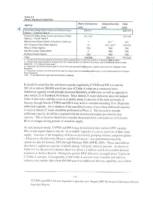
161
162
163

164