WETLAND DETERMINATION DATA FORM Eastern Mountains and Piedmont
|
|
|
- Julius Holt
- 5 years ago
- Views:
Transcription
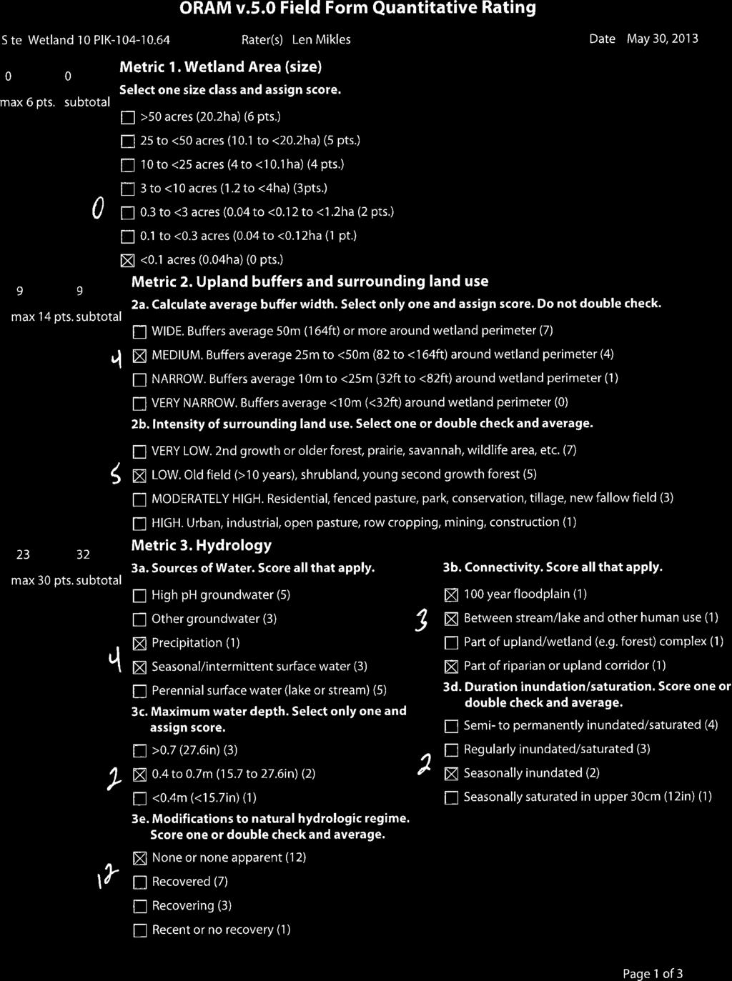
1 WETLAND DETERMINATION DATA FORM Eastern Mountains and Piedmont Project/Site: PIK (PID: 83667) City/County: Pike Sampling Date: Applicant/Owner: ODOT State: OH Sampling Point: 36 Investigator(s): Len Mikles Landform (hillslope, terrace, etc.): Gravel Bar Local relief (concave, convex, none): Convex Slope (%): 2 Subregion (LRR or MLRA): LRR N Lat: N Long: W Datum: NAD 1927 Soil Map Unit Name: Ge Genesee silt loam, occasionally flooded NWI Classification: N/A Are climatic/hydrologic conditions on the site typical for this time of year? Yes X No (If no, explain in Remarks.) Are vegetation, Soil, or Hydrology significantly disturbed? Are Normal Circumstances present? Yes X No Are vegetation, Soil X, or Hydrology naturally problematic? (If needed, explain any answers in Remarks.) Fluvial Deposits within Floodplains SUMMARY OF FINDINGS Attach site map showing sampling point locations, transects, important features, etc. Hydrophytic Vegetation Present? Yes X No Is the Sampled Area Hydric Soils Present? Yes X No Within a Wetland? Yes X No Wetland Hydrology Present? Yes X No Wetland 10 This sampling point was taken on a gravel bar. This area satisfies the three criteria necessary for a positive wetland determination. This area is a wetland. HYDROLOGY Wetland Hydrology Indicators: Primary Indicators (minimum of one is required; check all that apply) Secondary Indicators (minimum of two required) Surface Water(A1) True Aquatic Plants (B14) Surface Soil Cracks (B6) High Water Table (A2) Hydrogen Sulfide Odor (C1) Sparsely Vegetated Concave Surface (B8) Saturation (A3) Oxidized Rhizospheres on Living Roots (C3) Drainage Patterns (B10) Water Marks (B1) Presence of Reduced Iron (C4) Moss Trim Lines (B16) X Sediment Deposits (B2) Recent Iron Reduction in Tilled Soils (C6) Dry-Season Water Table (C2) X Drift Deposits (B3) Thin Muck Surface (C7) Crayfish Burrows (C8) Algal Mat or Crust (B4) Other (Explain in Remarks) Saturation Visible on Aerial Imagery (C9) Iron Deposits (B5) Stunted or Stressed Plants (D1) Inundation Visible on Aerial Imagery (B7) X Geomorphic Position (D2) Water Stained Leaves (B9) Aquatic Fauna (B13) Field Observations: Surface Water Present? Yes No X Depth (inches): Water Table Present? Yes No X Depth (inches): Shallow Aquitard (D3) Microtopographic Relief (D4) X FAC-Neutral Test (D5) Saturation Present? Yes No X Depth (inches): Wetland Hydrology Present? Yes X No (includes capillary fringe) Describe Recorded Data (stream gauge, monitoring well, aerial photos, previous inspections), if available: This area is located in the active channel of Crooked Creek. The area appears to be seasonally inundated. The sample point appears to be below the OHWM of the creek. Indicators of wetland hydrology were observed in the area. These observations satisfy the hydrology criterion. Eastern Mountains and Piedmont Interim Version
2 VEGETATION (Four Strata) Use scientific names of plants. Sampling Point: 22 Absolute Dominant Indicator Dominance Test Worksheet: Tree Stratum (Plot size: 30 ft ) % Cover Species? Status Number of Dominant Species 1. That are OBL, FACW, or FAC: 5 (A) Total Number of Dominant 4. Species Across All Strata: 5 (B) 5. = Total Cover Percent of Dominant Species Sapling/Shrub Stratum (Plot size: 15 ft ) That are OBL, FACW, or FAC: 100% (A/B) 1. Platanus occidentalis 10 Yes FACW Prevalence Index Worksheet: 2. Salix nigra 10 Yes OBL Total % Cover of: Multiply by: 3. Acer saccharinum 10 Yes FACW OBL Species 1 = 4. FACW Species 2 = 5. FAC Species 3 = 30 = Total Cover FACU Species 4 = Herb Stratum (Plot size: 5 ft ) UPL Species 5 = Column Totals: (A) (B) 1. Stachys tenuifolia 15 Yes FACW 2. Prevalence Index = B/A = 3. Hydrophytic Vegetation Indicators: Rapid Test for Hydrophytic Vegetation 5. X 2 - Dominance Test is > 50% Prevalence Index is Morphological Adaptations 1 (Provide supporting data in Remarks or on a separate sheet) 8. Problematic Hydrophytic Vegetation 1 (Explain) = Total Cover 1 Indicators of hydric soil and wetland hydrology Woody Vine Stratum (Plot size: 30 ft ) must be present, unless disturbed or problematic. 1. Toxicodendron radicans 15 Yes FAC Definitions of Four Vegetation Strata: = Total Cover Tree Woody plants, excluding vines, 3 in. (7.6 cm) or more in diameter at breast height (DBH), regardless of height Sapling/Shrub Woody plants, excluding vines, less than 3 in. DBH and greater than 3.28 ft (1 m) tall. Herb All herbaceous (non-woody) plants, regardless of size, and woody plants less than 3.28 ft tall. Woody vine All woody vines greater than 3.28 ft in height. (Include photo numbers here or on a separate sheet.) The Dominance Test is greater than 50 percent. This observation satisfies the vegetation criterion. Hydrophytic Vegetation Present? Yes X No Eastern Mountains and Piedmont Region Interim Version
3 SOIL Sampling Point: 22 Profile Description: (Describe to the depth needed to document the indicator or confirm the absence of indicators.) Depth Matrix Redox Features (inches) Color (moist) % Color ( moist) % Type 1 Loc 2 Texture Remarks YR 4/3 100 Sand >3 IMPENETRABLE Gravel 1 Type: C=Concentration, D=Depletion, RM=Reduced Matrix, MS= Masked Sand Grains. 2 Location: PL=Pore Lining, M=Matrix. Hydric Soil Indicators: Indicators for Problematic Hydric Soils 3 : Histosol (A1) Dark Surface (S7) 2 cm Muck (A10) (MLRA 147) Histic Epipedon (A2) Polyvalue Below Surface (S8) (MLRA 147, 148) Coast Prairie Redox (A16) (MLRA 136, 147) Black Histic (A3) Thin Dark Surface (S9) (MLRA 147, 148) Piedmont Floodplain Soils (F19) (MLRA 147, 148) Hydrogen Sulfide (A4) Loamy Gleyed Matrix (F2) Red Parent Material (TF2) Stratified Layers (A5) Depleted Matrix (F3) Very Shallow Dark Surface (TF12) 2 cm Muck (A10) (LRR N) Redox Dark Surface (F6) X Depleted Below Dark Surface (A11) Depleted Dark Surface (F7) Thick Dark Surface (A12) Redox Depression (F8) Sandy Mucky Mineral (S1) (LRR N, MLRA 147, 148) Iron-Manganese Masses (F12) (LRR N, MLRA 136) Sandy Gleyed Matrix (S4) Umbric Surface (F13) (MLRA 136, 122) Sandy Redox (S5) Piedmont Floodplain Soils (F19) (MLRA 148) Stripped Matrix (S6) Restrictive Layer (if observed): Type: Gravel Depth (inches): 3 Other (Explain in Remarks): Fluvial Deposits within Floodplains 3 Indicators of Hydrophytic vegetation and wetland hydrology must be present, unless disturbed or problematic Hydric Soil Present? Yes X No The soils observed do not correspond to none of the hydric soil indicator presented in the Field Indicators of Hydric Soils in the United States, Version 7.0 (2010). This sample point was taken on a gravel bar in an active floodplain. There is evidence of wetland hydrology and hydrophytic vegetation at this sampling point. As a result, the problematic hydric soils section of the regional supplement was consulted. It appears that the sampling point meets the criteria for the Fluvial Deposits within Floodplains problematic soil situation. These soils commonly occur on vegetated bars within the active channel and/or above the bankfull level of rivers and streams. In some cases, these soils lack hydric soil indicators due to seasonal or annual deposition of new soil material, low iron or manganese content, and/or low organic-matter content. These conditions appear to be present at the site. This observation satisfies the problematic hydric soils criterion. Eastern Mountains and Piedmont Interim Version
4 WETLAND DETERMINATION DATA FORM Eastern Mountains and Piedmont Project/Site: PIK (PID: 83667) City/County: Pike Sampling Date: Applicant/Owner: ODOT State: OH Sampling Point: 37 Investigator(s): Len Mikles Landform (hillslope, terrace, etc.): Stream/Road Embankment Local relief (concave, convex, none): Convex Slope (%): 15 Subregion (LRR or MLRA): LRR N Lat: N Long: W Datum: NAD 1927 Soil Map Unit Name: Ge Genesee silt loam, occasionally flooded NWI Classification: N/A Are climatic/hydrologic conditions on the site typical for this time of year? Yes X No (If no, explain in Remarks.) Are vegetation, Soil, or Hydrology significantly disturbed? Are Normal Circumstances present? Yes X No Are vegetation, Soil, or Hydrology naturally problematic? (If needed, explain any answers in Remarks.) SUMMARY OF FINDINGS Attach site map showing sampling point locations, transects, important features, etc. Hydrophytic Vegetation Present? Yes No X Is the Sampled Area Hydric Soils Present? Yes No X Within a Wetland? Yes No X Wetland Hydrology Present? Yes No X Out Point for Wetland 10 This sampling point was taken on a stream/road embankment. This area does not satisfy the three criteria necessary for a positive wetland determination. This area is not a wetland. HYDROLOGY Wetland Hydrology Indicators: Primary Indicators (minimum of one is required; check all that apply) Secondary Indicators (minimum of two required) Surface Water(A1) True Aquatic Plants (B14) Surface Soil Cracks (B6) High Water Table (A2) Hydrogen Sulfide Odor (C1) Sparsely Vegetated Concave Surface (B8) Saturation (A3) Oxidized Rhizospheres on Living Roots (C3) Drainage Patterns (B10) Water Marks (B1) Presence of Reduced Iron (C4) Moss Trim Lines (B16) Sediment Deposits (B2) Recent Iron Reduction in Tilled Soils (C6) Dry-Season Water Table (C2) Drift Deposits (B3) Thin Muck Surface (C7) Crayfish Burrows (C8) Algal Mat or Crust (B4) Other (Explain in Remarks) Saturation Visible on Aerial Imagery (C9) Iron Deposits (B5) Stunted or Stressed Plants (D1) Inundation Visible on Aerial Imagery (B7) Geomorphic Position (D2) Water Stained Leaves (B9) Aquatic Fauna (B13) Field Observations: Surface Water Present? Yes No X Depth (inches): Water Table Present? Yes No X Depth (inches): Shallow Aquitard (D3) Microtopographic Relief (D4) FAC-Neutral Test (D5) Saturation Present? Yes No X Depth (inches): Wetland Hydrology Present? Yes No X (includes capillary fringe) Describe Recorded Data (stream gauge, monitoring well, aerial photos, previous inspections), if available: This area is located along a strea/road embankment. Indicators of wetland hydrology were not observed in the area. These observations do not satisfy the hydrology criterion. Eastern Mountains and Piedmont Interim Version
5 VEGETATION (Four Strata) Use scientific names of plants. Sampling Point: 23 Absolute Dominant Indicator Dominance Test Worksheet: Tree Stratum (Plot size: 30 ft ) % Cover Species? Status Number of Dominant Species 1. Fraxinus pennsylvanica 15 Yes FACW That are OBL, FACW, or FAC: 2 (A) 2. Celtis occidentalis 15 Yes FACU 3. Total Number of Dominant 4. Species Across All Strata: 4 (B) = Total Cover Percent of Dominant Species Sapling/Shrub Stratum (Plot size: 15 ft ) That are OBL, FACW, or FAC: 50% (A/B) 1. Asimina triloba 15 Yes FAC Prevalence Index Worksheet: 2. Total % Cover of: Multiply by: 3. OBL Species 1 = 4. FACW Species 2 = 5. FAC Species 3 = 15 = Total Cover FACU Species 4 = Herb Stratum (Plot size: 5 ft ) UPL Species 5 = Column Totals: (A) (B) Prevalence Index = B/A = 3. Hydrophytic Vegetation Indicators: Rapid Test for Hydrophytic Vegetation Dominance Test is > 50% Prevalence Index is Morphological Adaptations 1 (Provide supporting data in Remarks or on a separate sheet) 8. Problematic Hydrophytic Vegetation 1 (Explain) = Total Cover 1 Indicators of hydric soil and wetland hydrology Woody Vine Stratum (Plot size: 30 ft ) must be present, unless disturbed or problematic. 1. Parthenocissus quinquefolia 15 Yes FACU Definitions of Four Vegetation Strata: = Total Cover Tree Woody plants, excluding vines, 3 in. (7.6 cm) or more in diameter at breast height (DBH), regardless of height Sapling/Shrub Woody plants, excluding vines, less than 3 in. DBH and greater than 3.28 ft (1 m) tall. Herb All herbaceous (non-woody) plants, regardless of size, and woody plants less than 3.28 ft tall. Woody vine All woody vines greater than 3.28 ft in height. (Include photo numbers here or on a separate sheet.) Dominance Test is less than 50 percent. This observation does not satisfy the vegetation criterion. Hydrophytic Vegetation Present? Yes No X Eastern Mountains and Piedmont Region Interim Version
6 SOIL Sampling Point: 23 Profile Description: (Describe to the depth needed to document the indicator or confirm the absence of indicators.) Depth Matrix Redox Features (inches) Color (moist) % Color ( moist) % Type 1 Loc 2 Texture Remarks YR 4/3 100 Loamy/Clayey >9 IMPENETRABLE Roots or Rock 1 Type: C=Concentration, D=Depletion, RM=Reduced Matrix, MS= Masked Sand Grains. 2 Location: PL=Pore Lining, M=Matrix. Hydric Soil Indicators: Indicators for Problematic Hydric Soils 3 : Histosol (A1) Dark Surface (S7) 2 cm Muck (A10) (MLRA 147) Histic Epipedon (A2) Polyvalue Below Surface (S8) (MLRA 147, 148) Coast Prairie Redox (A16) (MLRA 136, 147) Black Histic (A3) Thin Dark Surface (S9) (MLRA 147, 148) Piedmont Floodplain Soils (F19) (MLRA 147, 148) Hydrogen Sulfide (A4) Loamy Gleyed Matrix (F2) Red Parent Material (TF2) Stratified Layers (A5) Depleted Matrix (F3) Very Shallow Dark Surface (TF12) 2 cm Muck (A10) (LRR N) Redox Dark Surface (F6) Other (Explain in Remarks): Depleted Below Dark Surface (A11) Depleted Dark Surface (F7) Thick Dark Surface (A12) Redox Depression (F8) Sandy Mucky Mineral (S1) (LRR N, MLRA 147, 148) Iron-Manganese Masses (F12) (LRR N, MLRA 136) Sandy Gleyed Matrix (S4) Umbric Surface (F13) (MLRA 136, 122) Sandy Redox (S5) Piedmont Floodplain Soils (F19) (MLRA 148) Stripped Matrix (S6) Restrictive Layer (if observed): Type: Roots or Rock Depth (inches): 9 3 Indicators of Hydrophytic vegetation and wetland hydrology must be present, unless disturbed or problematic Hydric Soil Present? Yes No X The soils observed do not correspond to none of the hydric soil indicator presented in the Field Indicators of Hydric Soils in the United States, Version 7.0 (2010). This area does not satisfy the soils criterion. Eastern Mountains and Piedmont Interim Version
7
8


9