Environmental Assessment. Amador High Country Routes Project
|
|
|
- Alice Martin
- 5 years ago
- Views:
Transcription

1 United States Department of Agriculture Forest Service Pacific Southwest Region January 2016 Environmental Assessment for Amador High Country Routes Project Eldorado National Forest
2 In accordance with Federal civil rights law and U.S. Department of Agriculture (USDA) civil rights regulations and policies, the USDA, its Agencies, offices, and employees, and institutions participating in or administering USDA programs are prohibited from discriminating based on race, color, national origin, religion, sex, gender identity (including gender expression), sexual orientation, disability, age, marital status, family/parental status, income derived from a public assistance program, political beliefs, or reprisal or retaliation for prior civil rights activity, in any program or activity conducted or funded by USDA (not all bases apply to all programs). Remedies and complaint filing deadlines vary by program or incident. Persons with disabilities who require alternative means of communication for program information (e.g., Braille, large print, audiotape, American Sign Language, etc.) should contact the responsible Agency or USDA s TARGET Center at (202) (voice and TTY) or contact USDA through the Federal Relay Service at (800) Additionally, program information may be made available in languages other than English. To file a program discrimination complaint, complete the USDA Program Discrimination Complaint Form, AD-3027, found online at and at any USDA office or write a letter addressed to USDA and provide in the letter all of the information requested in the form. To request a copy of the complaint form, call (866) Submit your completed form or letter to USDA by: (1) mail: U.S. Department of Agriculture, Office of the Assistant Secretary for Civil Rights, 1400 Independence Avenue, SW, Washington, D.C ; (2) fax: (202) ; or (3) program.intake@usda.gov. USDA is an equal opportunity provider, employer and lender.
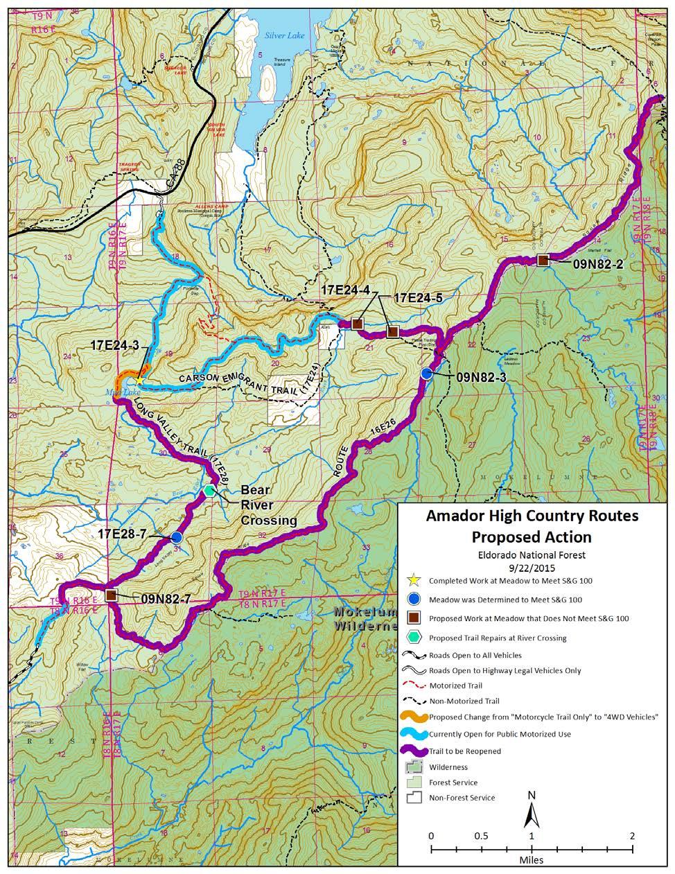
3 Introduction The Amador High Country Routes Environmental Assessment proposes and analyzes treatments to repair roads and trails that are currently not meeting forest plan standard and guidelines. This analysis is intended to inform a decision that may allow these roads and trails be made available to public motor vehicle use. This analysis is tiered to and is part of the implementation of the Record of Decision for the 2013 Eldorado National Forest Travel Management Supplemental Environmental Impact Statement (TM SEIS), which identified 18 routes where corrective actions were needed prior to adding the routes back onto the Eldorado National Forest Motor Vehicle Use Map (MVUM) as designated for public wheeled motor vehicle use. As stated in the 2013 TM SEIS, trails would remain closed to public motorized vehicles until 1) the routes were brought into compliance with the 2004 Sierra Nevada Forest Plan Amendment (SNFPA) Standard and Guideline 100 as it pertains to meadows, and 2) a Biological Assessment and conferencing or consultation with U.S. Fish and Wildlife Service were completed if corrective actions or vehicle traffic could affect the Sierra Nevada yellow-legged frog (SNYLF) or the Yosemite toad or their critical habitats. The project is located at meadows 17E24-3, 17E24-4, 17E24-5 and 09N82-2 on the Carson Emigrant National Recreation Trail (17E24) and meadow 09N82-7 on the Forest System Trail16E26. The trails are located on the Amador Ranger District, Eldorado National Forest, T 8N, R17E, Sections 5 and 6; T9N, R17E, Sections 11,14, 15, 19, 20, 21, 22, 28, 29, 30, 31, 32, 33; T9N, R16E, Section 36; and T9N, R18E, Section 6; MDBM. These locations were identified in the TM SEIS as not meeting SNFPA Standard and Guideline 100 with respect to hydrologic connectivity of the meadows. During site visits with the interdisciplinary team in 2014 and July, 2015, Meadow 09N82-3 on Forest System Trail 16E26 and Meadow 17E28-7 on the Long Valley Trail were re-evaluated and determined to be meeting SNFPA Standard and Guideline 100. The OHV use on these trails prior to the temporary closure has been relatively low as compared to some other OHV routes on the Forest. The area is remote. Users typically do day trips, either out and back or a loop trip. Some users use the trails to access the ridge and do hikes into the Mokelumne Wilderness. Although formal use counts were not conducted, Amador District recreation staff estimate the use to have been approximately 400 to 500 vehicles per year on these trails. Assuming a use season of July through October, this would equate to an average of about 3 to 4 vehicles per day during the use season. In addition to the corrective actions needed to comply with SNFPA Standard and Guideline 100, the proposed action will address some proposed work at a crossing of a tributary to Bear River on the 1
4 Long Valley Trail (17E28) where sediment has the potential to enter a creek, and analyze a change in the vehicle type designation on the northernmost.52 mile section of the Long Valley Trail. This section of the trail is full width for High Clearance vehicles and has been used to access dispersed recreation sites on the west side of Mud Lake for many years. The current vehicle type designation, however, does not differentiate between this section of trail and the remainder, which is single track. The entire route is currently designated for Motorcycles Only. Purpose and Need The primary purpose of this project is to implement corrective actions for the selected routes as prescribed in the Record of Decision for the 2013 TM SEIS to comply with the SNFPA Standard and Guideline 100 as it pertains to OHV routes and meadows in the Eldorado National Forest. Since the TM SEIS did not analyze the corrective actions necessary to bring each route into compliance with SNFPA Standard and Guideline 100, there is a need to complete environmental analysis on the actions needed to open routes identified in the SEIS as not currently meeting SNFPA Standard and Guideline 100. Standard and Guideline (S&G) 100: Maintain and restore the hydrologic connectivity of streams, meadows, wetlands and other special aquatic features identifying roads and trails that intercept, divert or disrupt natural surface and subsurface water flow paths. Implement corrective actions where necessary to restore connectivity. The following meadows on the Carson Emigrant Trail and Forest System Trail 16E26 were identified as needing corrective actions: Carson Emigrant National Recreation Trail (17E24) Meadow 17E24-3 (near Mud Lake) Two rolling dips were constructed in the trail near the south end of meadow just north of the road barricade in June of Although that section of the trail has been repaired and reopened to public wheeled vehicle use, it would be beneficial to reinforce those rolling dips with a gravel cap for longevity. Meadow 17E24-4 (near Allen s Camp) There are two small intermittent stream crossings in the trail as it traverses the northern edge of this meadow. Road derived sediment in the channel Was not observed, however vehicle crossings on the gravel substrate in the stream crossings does stir up silt and fine sands from the interstitial pores of the gravel and create small sediment plumes to a pool below the crossing. These streams flow into 2
5 the meadow at Allen Camp where Sierra Nevada yellow-legged frogs have been observed in the past. Meadow 17E24-5 (between Allen s Camp and Forest System Trail 16E26) The area of the trail needing repair is approximately yards long located alongside a steep drainage with a meadow complex. The meadow areas are cut through by several recently scoured channels originating from the ridge, but not associated with road. Water runs approximately 300 feet down the trail before draining onto an adjacent meadow, resulting in a gully. There are also two perennial springs on the upslope side of the road. Water from these springs runs down the road 50 feet or more before exiting, in one case creating an incision in the soil up to 3 feet deep. The water running down the trail has created ruts in the trail. At one shady location where snowbanks hang late in the year vehicles have traveled around and off of the trail creating ruts in the adjacent meadow. Meadow 09N82-2 (near Martell Flat): This part of the Carson Emigrant Trail is very close to the topographic divide of a ridge running east to west. Large meadows occupy the slopes both north and south of the trail. The trail is incised approximately 8 to 9 inches at the head of a large meadow (5 acres or more), part of a meadow complex on the north facing slope. At this point runoff ponds on the trail. There are many small scour channels coming off hillsides onto meadows and widespread evidence of sand/gravel sediment fans emanating from the hillsides. These erosional features do not result from trail 17E24. From the east the trail has downslope gradient to the ponded point and a single drainage point where a small amount of granitic sand leaves the prism with no visible effect on meadows. It is not affecting hydrologic connectivity as water that collects there does not travel down the trail. From the south approach to the meadow, a small of amount of sediment was observed coming off of the steeper sections of the trail as it descends into the meadow. Several rolling dips appear to have been in place at one time on that section of the trail, but they have been worn down and are no longer effective. At a steep section just south of the meadow where the trail turns east before descending into the meadow, some erosion has been occurring and the trail has been widening as result of vehicles driving around the steep section. Some movement of sediment off of the trail below this location towards an extension of Meadow 09N82-2 below has occurred. The area affected is approximately feet wide for 200 feet down a steep slope. 3
6 Forest System Trail 16E26 Meadow 09N82-7 (At the south end of Forest System Trail 16E26 near the intersection with the Long Valley Trail (17E28: The trail parallels meadow 09N82-7 for approximately100 to 150 yards. The hill slopes above the meadow appear degraded with 40-50% or more bare ground, predominately mule ears and visibly high rate of surface erosion mounding behind rocks and vegetation. Small scour channels forming on the hill slopes cut down into the meadow on both sides at multiple points. A small scour channel in the meadow leads to a head cut of about 3 feet. The trail contributes runoff from about 25 feet of its length, but that is a minor amount compared to amount from the nearby slopes. A 200 foot section of trail farther upslope does contribute runoff to a single point that enters the meadow. It has deposited a small amount of sediment, but without energy sufficient to cause any scour to the meadow surface. Federally Listed Amphibian Species The second purpose of this project is to analyze the potential effects of reopening the Carson Emigrant Trail (17E24), Forest System Trail16E26, and Long Valley Trail (17E28) on the recently listed amphibian species, the Sierra Nevada yellow-legged frog and the Yosemite Toad, and consult with the U.S. Fish and Wildlife Service (USFWS) regarding impacts to the newly listed amphibian species from both the proposed repair work and reopening the closed portions of the routes. Long Valley Trail (17E28) Although it was determined that the meadows on the Long Valley Trail were meeting S&G 100, the Interdisciplinary Team identified concerns with one crossing of a southern tributary to Bear River where erosion was occurring and the stream channel actively widening at the trail crossing. The team identified areas downstream of the crossing that could be potential suitable habitat for SNYLF. Habitat for the SNYLF may be negatively affected by sedimentation caused by the eroding trail crossing. Vehicle Use Designation Change The third purpose of this project is to consider a change in the vehicle type designation on the northernmost.52 miles of the Long Valley Trail to reflect the actual field conditions. The route is currently designated as a Motorcycle Trail. However, that section of the trail is used by 4wd vehicles to access dispersed camping sites on the west side of Mud Lake. The motorcycle trail actually begins near the south end of Mud Lake. 4
7 Public Involvement A scoping letter and description of the proposed action was sent to interested parties including all appellants of the 2013 Eldorado National Forest Travel Management SEIS, and El Dorado, Amador and Alpine counties on July 10, 2015, with comments requested by August 22, The project was also listed in the SOPA and proposed action posted of the Eldorado National Forest website. One letter with multiple signatories was received with comments on the proposed action. The comments were used to help shape the analysis in this document, including the development of Alternative 2, which considers a reroute of Forest System Trail 16E26 at Meadow 09N82-7. A summary of the comments received and how they were considered is available in the project file. A legal notice for the opportunity to comment on the Preliminary EA was published in the Mountain Democrat, as well as Ledger Dispatch on November 13, Letters were sent to interested parties including persons who provided scoping comments, all appellants of the 2013 Eldorado National Forest Travel Management SEIS, and El Dorado, Amador and Alpine counties on November 12, The Preliminary EA and legal notice announcing the opportunity to comment was also posted on the project website. Three letters were received during the 30-day comment period to the EA. The summary of comments received during the 30-day comment period and how they were considered is included in Appendix I of the EA. Alternatives Alternative 1 - Proposed Action (See Map on page 12) The proposed action was modified slightly from the description sent out for Public Scoping. The edits were made primarily for clarification. Carson Emigrant National Recreation Trail (17E24) The Eldorado National Forest, Amador Ranger District proposes to repair the Carson Emigrant National Recreation Trail (Forest System Trail 17E24) at Meadows 17E24-4, 17E24-5 and 09N82-2, and perform additional work at Meadow 17E24-3. Details of the repairs to be constructed include: Meadow 17E24-3 (near Mud Lake) Two rolling dips were constructed in the trail near the south end of meadow just north of the road barricade in June of Under this project, additional aggregate base rock may be brought in and installed as a cap on the rolling dips to strengthen them and ensure their longevity. 5
8 Meadow 17E24-4 (near Allen s Camp) Construct two rolling dips in the trail on the east (uphill) approach to the floodplain containing the two small stream crossings to reduce the potential for sediment coming down the trail and into the drainages. A small borrow area has been identified at the easternmost dip on both sides of the road. Each area is approximately 15 x 30 feet. Average depth of borrow would be approximately 2 feet, and would not be excavated lower than the existing trail. Meadow 17E24-5 (between Allen s Camp and Forest System Trail 16E26) Reconstruct a segment of trail approximately 600 to 675 feet long that passes through a small complex of meadows and natural springs to stop the current diversion of water down the trail and restore the natural flow of water through the meadow complex. The work will consist of a combination of the following: Construction of rolling dips, regrading sections of trail to correct drainage, and reconstructing sections of the trail in wet areas with permeable materials (rock, bin walls and/or geotextiles, small drainage pipes) designed to allow the water to pass across the trail from meadow areas on the uphill side to meadow areas on the downhill side. It is anticipated that approximately five rolling dips will be installed, and three sections of trail will be reconstructed (see map in Appendix E). One of the reconstruction sections will include routing a pipe from a spring on the uphill side of the trail to the downhill side of the trail. Some aggregate base rock and/or riprap will be imported for use in the trail reconstruction. Slight alignment corrections may be made where users have driven around potholes or snowbanks. Up to 15 trees may be removed on the road shoulder to facilitate corrections in alignment where vehicles have been deviating from the trail into an adjacent meadow area to get around a spot on the trail where snowbanks are late to melt. Tracks in the meadow vegetation in this location will be filled in with hand tools and slash placed to disguise the tracks and facilitate revegetation,. This location is notes as Restoration Area on the map for Meadow 17E24-4 and 17E24-5 Repairs (see map in Appendix E). One additional rolling dip (Dip 0 on the map) will be installed in the trail approximately 660 feet to the west at an additional drainage location to divert water off of the road. A map diagram showing the proposed work at Meadows 17E24-4 and 17E24-5 is located in Appendix E. Meadow 09N82-2 (near Martell Flat) On the portion of the trail that drops down into the south side of Meadow 09N82-2, one or two rolling dips will be constructed, or existing dips or outlets cleaned out or repaired, to divert water and any sediment off of the trail before it reaches the meadow. At the steep section just south of the meadow where the trail turns east before descending into the meadow, small check dams will be constructed below the trail where sediment appears to be moving off of the trail. Some rock and down woody material and will also be installed on the inside of the curve on the steep section of trail where the erosion has been originating to discourage traffic there, narrowing the trail to its proper width and providing cover for the exposed soil. 6
9 Forest System Trail 16E26 Repair Forest System Trail 16E26 at Meadow 09N82-7. Details of the repairs to be constructed include: Meadow 09N82-7 (At the south end of Forest System Trail 16E26 near the intersection with the Long Valley Trail (17E28): Construct three to ten rolling dips in the trail on the south western approach to the meadow to dissipate runoff energy and quantity from the road onto multiple points onto the forest floor before it reaches the meadow. A section of the existing trail 200 to 400 feet in length adjacent to the meadow would be armored with aggregate base rock to stabilize the trail and minimize the potential for rill erosion along the roadway (see map in Appendix F.) Woody debris would also be placed below the route to provide a buffer for the meadow at locations where sediment from the adjacent hillside has been washing across the route. Long Valley Trail (17E28) The Vehicle Use Designation on the northernmost.52 mile segment of Long Valley Trail (17E28) on the west side of Mud Lake would be changed from NFTS Trail: Open to Motorcycles Only to NFTS Trail: Open to All High Clearance Vehicles to permit legal access to dispersed camping sites on the west side of Mud Lake. The remainder of the single track portion of the trail from Mud Lake to Onion Valley would remain designated NFTS Trail: Open to Motorcycles only. Some repairs will be made to stabilize the crossing of the Long Valley Trail (17E28) at one of the southern tributaries to Bear River where concerns were identified regarding erosion of sediment into the creek. The trail approaches to the creek would be reinforced with rock to be collected from a nearby source. The work on Long Valley Trail is anticipated to be done by a crew using hand tools. Implementation: The existing transportation system will be used for bringing in equipment and materials to the extent feasible. Due to the remote location of meadows on 17E24 and 16E26, it is anticipated that a helicopter may be utilized to long line some of the mechanical equipment, rock materials and water for compaction in and out of the project sites. If helicopters are used, anticipated construction period for helicopter operations is August 15 - October 31. Sites being considered for helicopter staging areas include Lumberyard, the Tragedy Springs Quarry, a previous construction staging area adjacent to the Lower Bear River Dam, and the old Iron Mountain Ski Area. It is anticipated that the equipment and materials would be dropped directly within the existing trail width so as not to impact other areas at the project sites. Some snags or live trees may need to be felled at drop points if it is determined that they will pose a hazard during construction. Water for compaction at trail improvements may be drafted from Mud Lake into a small tank on the back of a truck using 7
10 approved aquatic organism screens. Any water that is flown in will be obtained from an approved source. Where practical, the Eldorado National Forest will consider the use of volunteers to transport personnel and/or materials or assist with the labor to implement the proposed work on the OHV trails. Reopening of Trails The use designation on the northernmost.52 mile section of the Long Valley Trail would be changed and that section reopened immediately. The remainder of the Long Valley Trail (17E28) will be reopened upon completion of the improvements to the crossing at Bear River. The Carson Emigrant Trail (17E24) and Forest System Trail 16E26 will be reopened upon completion of the corrective measures that bring the routes in compliance with S&G 100. It is expected that portions of the project will be implemented in the field season (summer/fall) of 2016, and other portions in the field season of 2017.As the work may be done in stages, individual routes or sections of routes will be reopened when the work on that route or section is completed. Design Criteria The following mitigation measures and coordinating requirements are incorporated into this alternative: Land Acquisition Construction of rolling dips on Forest System Trail 16E26 above Meadow 09N82 will be conditional on completion of a land acquisition in progress whereby the parcel located at T9N R 16E section 36 will become National Forest System land. Riparian Conservation Areas Work at meadows and streams would be completed in the late summer and/or fall - when aquatic features and trails are usually at their driest - in order to minimize effects to these features. No fuel storage would take place within RCAs. Refueling would take place in RCAs only where there is no other alternative. Sensitive Plants and Noxious Weeds Should any TES species or watch list plant species be located associated with this project location district biology staff would be informed, and steps taken to evaluate, and mitigate any possible effects not covered by this assessment. All off-road equipment would be cleaned to insure it is free of soil, seeds, vegetative matter or other debris that could contain seeds before entering the project area. 8
11 Any straw or mulch used for erosion control would be certified weed-free. A certificate from the county of origin stating the material was inspected is required. Any revegetation material used for restoration or erosion control would be from a locally collected source. Infestations of noxious weeds that are discovered during project implementation would be documented and locations mapped. New sites would be reported to the Forest botanist. All gravel, fill, rock or other material would be weed free. Onsite sand, gravel, or rock would be used where possible. Off-site equipment staging areas used for helicopter transport will be free of invasive species. Known infestations within the vicinity of proposed helicopter staging areas would be identified and avoided during project implementation. Any areas of bare ground created during trail reconstruction activities off of existing roads and trails would be replanted with an appropriate mix of native species developed by the project botanist. No Pinus albicaulis will be cut as part of this project. If equipment is going to operate outside the existing trail width in the vicinity of either of the two known occurrences of Lewisia kelloggii ssp. hutchisonii along route 17E24 and 17E79. the project botanist will be contacted to flag the species locations to be avoided. The occurrence along 17E24 (LEKE # ) is along the ridge between meadow 17E24-5 and 09N82-2 and includes approximately 1 mile of 17E24. The other occurrence bisected by 17E79 (LEKE #028-01) extends between the intersection with the Porthole Gap 4wd trail and Allen Camp Trail. If Lewisia kelloggii is found along the proposed reroute at meadow 09N82-7 individuals plants within the proposed trail corridor would be transplanted and physical barricades would be placed along the trail to limit vehicles from traveling off designated route into potential habitat. Terrestrial and Aquatic Wildlife Helicopter operations for delivery of project materials would be planned, if possible, to take place outside of the reproductive periods for California spotted owl (March 1 through August 15 th ) and/or northern goshawks (February 15 through September 15). Should helicopter flights and reproductive periods coincide, the flights would be directed outside of northern goshawk and California spotted owl Protected Activity Centers (PACs), identified during flight planning (See map in Appendix H.) Should any TES species or watch list species be located associated with this project location, district biology staff would be informed, and steps taken to evaluate, and mitigate any possible effects not covered by this assessment. The use of low velocity water pumps and screening devices for pumps (per S&G 110) will be utilized during drafting for project treatments to preventing mortality of eggs, tadpoles, juveniles, and adult SNYLF. A drafting box measuring 2 feet on all sides covered in a maximum of 0.25 inch screening is required. 9
12 A survey for Sierra yellow-legged frog and Yosemite Toad will be conducted by qualified FS personnel just prior to project implementation at the location of the proposed repairs at each work site. If the Sierra Nevada yellow-legged frog or Yosemite toad are found within the project area during project implementation, their safety shall be assessed by qualified personnel and dealt with according to the Terms and Conditions described in the 2014 Programmatic Biological Opinion issued by the US Fish and Wildlife Service. Cultural Resources Should any previously unrecorded cultural resources be encountered during implementation of this project, all work should immediately cease in that area and the District Archaeologist be notified immediately. Work may resume after approval by the District Archaeologist; provided recommended Standard Protection Measures are implemented. Should any cultural resources become damaged in unanticipated ways by activities proposed in this project; the steps described in the Regional PA for inadvertent effects will be followed. Should the project boundaries or activities be expanded beyond the current APE, Section 106 compliance for this project will be incomplete until additional cultural resource review is completed. Visual Resources Selection of materials for project construction including concrete paver blocks and rock shall be done to blend with the colors of the surrounding environment as much as possible. A natural agent to hasten weathering of rock such as Permeon may be used on finished exposed rock within the trail to darken the rock surfaces to match the adjacent areas and reduce visual impacts of construction. Helicopter Operations and Public Safety A project Aviation Plan will be prepared, and helicopter operations coordinated through the Forest Aviation Officer. Temporary traffic control for staging areas shall meet all requirements as stated in the Manual on Uniform Traffic Control Devices (MUTCD). Part 6, Chapter 6A-6I, located at Monitoring Project Implementation Monitoring will be done to determine the effectiveness of corrective actions taken for Meadows 17E24-3, 17E24-4 and 17E24-5 on the Carson Emigrant National Recreation Trail (17E24) and meadows 09N82-2 and 09N82-7 on Forest Route 16E26. The monitoring will be done in accordance with the 2015 Monitoring Plan: Eldorado National Forest Travel Management Settlement Agreement. In addition to the reconstruction work to be done at the three meadows identified above, routine trail 10
13 maintenance work and trail condition monitoring will continue to occur on an ongoing basis on Amador District 4wd trails. The Protocols for Trail Condition Assessment, Maintenance and Monitoring are spelled out in detail in the annual Eldorado National Forest Soil Conservation Plan which is updated annually. This plan addresses how the State of California 2008 Soil Conservation Standards will be met. 11
14 12
15 Alternative 2 This alternative is the same as Alternative 1, with the exception for the work to be done on Forest System Trail 16E26 at Meadow 09N82-7. Meadow 09N82-7 (At the south end of Forest System Trail 16E26 near the intersection with the Long Valley Trail (17E28) Construct three to ten rolling dips in Forest System Trail 16E26 on the south western approach to the meadow to dissipate runoff energy and quantity into multiple points onto the forest floor before it reaches the meadow to reduce the amount of water travelling down the original road alignment into the meadow. A trail reroute approximately.32 miles in length would be constructed around the northern side of the meadow. The reroute would begin near the intersection of Forest System Trail 16E26 and the Long Valley Trail (17E28). It would loop around the northern side of Meadow 09N82-7, and tie back into Forest System Trail 16E26 on the northern side of the small drainage that flows out of the meadow. Most of the proposed reroute would be 160 to 400 feet from the meadow. The original section of Forest System Trail 16E26 on the south side of the meadow, approximately.23 miles in length, would be restored by blocking both ends with fallen logs, scattering woody material on the trail, and reseeding the area with native grasses. See Map in Appendix G. The first 100 feet of the Long Valley Trail will be adjusted as necessary, up to 30 feet to the west, to create a well-designed intersection with the new Forest System Trail 16E26 reroute, and new signing installed. Alternatives Considered but Eliminated from Detailed Study A reroute was explored for the upper end of the Carson Emigrant Trail that would avoid Meadow 17E24-5 by constructing a new trail segment higher on the hillside above the spring areas and south of the existing route up to the ridgetop. Upon further investigation by the project team, this potential reroute was eliminated from detailed study due to the steep grades involved and degree of blasting required. In addition, the most feasible alignment for the reroute followed a portion of the historic trail which contained wagon ruts and other features of interest, and construction of a reroute on that alignment would have obliterated the remains of the historic trail. In addition, the existing issues with hydrologic connectivity along the existing alignment would need to be mitigated, with similar impacts to that portion of the trail as described in Alternative 1. An additional reroute was also explored at Meadow 09N82-7 at the south end of Forest system Trail 16E26, on the south side of the meadow that would move the route up the hillside further away from the meadow. Due to the geology of the slopes in that vicinity the team concluded that a reroute would likely cause further erosion of sediment into the meadow, and would not be a desirable solution. 13
16 A third alternative that was considered but eliminated from detailed study was to implement corrective actions to restore hydrological connectivity and reduce sedimentation, but leave the trails closed to public motor vehicle use. This alternative was eliminated from further analysis as it would not be consistent with the Record of Decision for the 2013 Eldorado National Forest Travel Management SEIS, which states that After corrective actions have been designed and implemented, the route[s] would appear as a designated public motor vehicle road or trail on the next revision of the MVUM. Minimization Criteria The minimization criteria in 36 CFR apply to the designation of roads, trails, and areas for motor vehicle use. This section of the CFR states that In designating National Forest System trails and areas on National Forest System lands, the responsible official shall consider effects on the following, with the objective of minimizing: (1) Damage to soil, watershed, vegetation, and other forest resources; (2) Harassment of wildlife and significant disruption of wildlife habitats; (3) Conflicts between motor vehicle use and existing or proposed recreational uses of National Forest System lands or neighboring Federal lands; and (4) conflicts among different classes of motor vehicle uses of National Forest System or neighboring Federal lands The 2013 Eldorado National Forest Travel Management SEIS was tiered to the 2008 Travel Management EIS. The 2013 Supplemental EIS focused on supplemental analysis of hydrology and meeting S&G 100 as it pertained to meadows. Minimization of impacts to other resources was addressed in the 2008 Travel Management EIS. A discussion of minimization of damage to meadows was included on page 56 of the 2013 Travel Management SEIS where it was identified that implementing Alternative 3 (the alternative selected in the ROD) would meet 36CFR (b) with respect to minimizing damage to meadows from ten trails, including the trails covered in the Amador High Country Routes EA. This was because the ten trails that do not meet S&G 100 would remain closed to public motorized vehicle use until corrective measures that will minimize adverse effects to meadows and ensure compliance with S&G 100 are implemented. The Amador High Country Routes EA is tiered to the 2013 Travel Management SEIS. In addition to analysis of the corrective actions needed to meet S&G 100, this EA also considers effects to newly listed amphibian species and their habitats from implementing the corrective actions and reopening the trails to public motorized use. The Biological Assessment and Evaluation of Aquatic Species for the Amador High Country Routes Project (Chow and Santora, January 11, 2016) (BA/BE) for this project identifies that under Alternative 1, although reopening of routes 17E24, 16E26 and 17E28 to public use and the change in designation of the northernmost.52 miles of the 3.81 mile Long Valley Trail (17E28) from motorcycle only to 4wd vehicle use would result in an increase in sediment and increase in potential harassment/injury/mortality to the SNYLF as compared to the current closed trail status, the proposed corrective actions at Meadows 17E24-3, 17E24-4, 17E24-5, 09N82-2 and 09N82-7 are expected to indirectly improve SNYLF habitat through overall sediment reduction into nearby 14
17 suitable SNYLF habitat as compared to taking no action. The improvements at the 17E28 Bear River crossing are designed to reduce sediment delivery into the creek and are expected to improve SNLYF habitat in the long term as compared to taking no action (BA/BE page ) While the proposed corrective activities may cause some short term effects to suitable habitat inside Proposed Critical Habitat for the SNLYF, during and immediately after implementation, they are expected to improve existing route conditions to PCH in the long term (BA/BE page 44.) The BA/BE for this project identifies that under Alternative 1, reopening of routes 17E24, 16E26 and 17E28 to public use and the change in designation of the northernmost.52 miles of the 3.81 mile Long Valley Trail (17E28) from motorcycle only to 4wd vehicle use would result in an increase in sediment and increase in potential harassment/injury/mortality to the YOTO as compared to the current closed trail status, the proposed corrective actions at Meadows 17E24-3, 17E24-4, 17E24-5, 09N82-2 and 09N82-7 are expected to indirectly improve the suitable YOTO meadow and upland habitat through reduced sedimentation as compared to taking no action. The improvements at the 17E28 Bear River crossing are expected to improve YOTO habitat in the long term as compared to taking no action (BA/BE page ). Although there are some slight differences in the effects to SNYLF and YOTO between alternatives 1 and 2, the difference is very small in scale (BA/BE, page 56.) Consideration of effects to these aquatic species is described in detail in the Biological Assessment and Evaluation of Aquatic Species for the Amador High Country Routes Project (Chow and Santora, January 11, 2016) (BA/BE) for this project. The same corrective actions that have been designed to comply with Standard and Guideline 100 as it pertains to meadows also have beneficial long term effects to SNYLF and YOTO and their habitat. Overall, implementation of proposed route corrective actions may affect SNYLF and YOTO habitat in the short-term, but will be beneficial in the long term for both SNYLF and YOTO habitat (BA/BE page 56-57). Opening the routes would result in an increase in vehicular traffic leading to sediment delivery into streams or meadows and increase the risk of disturbance, injury or crushing of the SNYLF or YOTO, leading to may affect and likely to adversely affect findings for the SNYLF and YOTO. However, the degree to which the proposed actions may adversely affect the SNYLF is minor and small in scale, affecting.04% of the suitable habitat within the aquatic analysis area for SNYLF and 0.5% of the aquatic analysis area for YOTO. The amount of use of these routes is estimated to be low (less than 500 vehicles/year) and had been ongoing prior to 2013 (between years). In addition, the actions proposed for this project are 1) routine in nature, 2) have been implemented in the past under similar conditions, 3) would directly overlap with a very small portion of suitable habitat, 4) would employ standard practices (S&G s and BMP) and protection measures [design criteria, including applicable conservation measures in the 2014 USFWS Biological Opinion], and 5) have known possible effects. (BA/BE, page 56-57) Tiering and Incorporation by Reference In order to eliminate repetitive discussion and documentation, this Environmental Assessment tiers to the Eldorado National Forest Land and Resource Management Plan (LRMP of 1989) as amended by the Sierra Nevada Forest Plan Amendment, (January 2004), the 2008 Eldorado National Forest 15
18 Public Wheeled Motorized Travel Management EIS and ROD, and the Eldorado National Forest Travel Management SEIS ROD (June, 2013). The following documents prepared for this analysis are incorporated by reference: Monitoring Plan: Eldorado National Forest Travel Management SEIS Settlement Agreement (Eldorado National Forest, March 19, 2015) Soil Conservation Plan, USDA Forest Service (Eldorado National Forest, 2015) Eldorado National Forest Amador Ranger District, Amador High Country Routes Project: Hydrology Report (Steve Markman. Eldorado National Forest, October 29, 2015, Revised December 22, 2015) Riparian Conservation Objectives (RCO) Consistency Report, Amador High Country Routes (Steve Markman, Joe Chow, and Matt Brown. Eldorado National Forest, October 29, 2015) Biological Evaluation and Assessment for Terrestrial Threatened, Endangered and Sensitive Wildlife Species: Amador High Country Routes Project (Chuck Loffland, Eldorado National Forest, November 3, 2015) Project Management Indicator Species Report, Amador High Country Routes (Chuck Loffland, Eldorado National Forest, November 3, 2015) Bald Eagle/Gold Eagle NEPA Report for Amador High Country Routes Project (Chuck Loffland, Eldorado National Forest, November 3, 2015) Migratory Landbird Conservation Report for Amador High Country Routes Project (Chuck Loffland, Eldorado National Forest, November 3, 2015) Programmatic Biological Opinion on Nine Forest Programs on Nine National Forests in the Sierra Nevada of California for the Endangered Sierra Nevada Yellow-legged frog, Endangered Northern Distinct Population Segment of the Mountain Yellow-legged Frog, and Threatened Yosemite Toad. (USDI UFWS, December 19, 2014) Biological Assessment and Evaluation of Aquatic Species for the Amador High Country Routes Project (Joseph Chow and Maura Santora, Eldorado National Forest, January 11, 2016) Biological Assessment/Evaluation for Botanical Species, Amador High Country Routes Project (Matt Brown, Eldorado National Forest, November 30, 2015) Cultural Resource Management Report, Amador High Country Routes R (Miranda Gavalis, Eldorado National Forest, December 17, 2015) 16
19 Environmental Consequences Effects Relative to Finding of No Significance (FONSI) Elements In 1978, the Council on Environmental Quality published regulations for implementing the National Environmental Policy Act (NEPA). These regulations (40 CFR Parts ) include a definition of significant as used in NEPA. The ten elements of this definition are critical to reducing paperwork through use of a finding of no significant impact (FONSI) when an action would not have a significant effect on the human environment, and is therefore exempt from requirements to prepare an environmental impact statement (EIS). Significance as used in NEPA requires consideration of the following ten intensity factors in the appropriate context for that factor. (1) Impacts may be both beneficial and adverse. A significant effect may exist even if the Federal agency believes that, on balance, the effect will be beneficial. Mitigations and management requirements designed to reduce the potential for adverse impacts were incorporated into the proposed action and alternatives, including standards and guidelines outlined in the Eldorado National Forest LRMP (USDA Forest Service 1989), as amended by the Sierra Nevada Forest Plan Amendment (USDA Forest Service 2004), Best Management Practices, and project specific design criteria based on resource specialist knowledge and experience. These mitigations and management requirements would minimize or eliminate the potential for adverse impacts caused by the proposed project. A discussion of potential effects is summarized below from supporting analysis (Hydrology Report (dated 10/29/15, revised 12/22/15); Biological Assessment and Evaluation for aquatic species (dated 1/11/16); Biological Evaluation and Assessment for terrestrial wildlife species (dated 11/3/15); and Biological Assessment/Evaluation for botanical species (dated 11/30/15). All analyses prepared in support of this document considered both beneficial and adverse effects, but all effects determinations were made on the basis of only adverse effects. None of the potential adverse effects of the proposed action or alternatives would be significant, even when considered separately from the beneficial effects that occur in conjunction with those adverse effects. Hydrology Alternative 1 Four meadows (17E24-4, 17E24-5, 09N82-2, and 09N82-7) would be brought into compliance with Standard & Guideline (S&G) #100 of the 2004 Sierra Nevada Forest Plan Amendment (SNFPA) because the repairs to improve segments of trails 17E24 and 16E26 of the four meadows would result in the following: Runoff and sediment from trails 17E24 and 16E26 into the meadows listed above would be greatly reduced. 17
20 The movement of surface water and subsurface water through meadow 17E24-5 would be improved. There would likely be no change or a negligible change in the amount of runoff and sediment from trail 17E24 into Meadow 17E24-3 (east side of Mud Lake) for two reasons: Repairs to a segment of trail 17E24 near meadow 17E24-3 were completed in June These repairs, which are described in Appendix A, are expected to greatly reduce the amount of runoff and sediment from trail 17E24 that reaches meadow17e24-3. Trail 17E24 is currently being used by different types of motorized vehicles. The change in vehicle type designation on the northernmost 0.52 miles of trail 17E28 merely reflects the current use of that segment of the trail. Trail 17E28 would contribute less runoff and sediment into a tributary of the Bear River where the trail crosses the stream, and additional widening of the stream channel as a result of trail 17E28 at this location would not occur as compared to taking no action. This is because the trail approaches to the stream crossing, as well as short segment of the stream channel, would be reinforced with rock. Ground disturbance would occur in less than 10 percent of meadows and their associated Riparian Conservation Areas (RCAs). The primary reason for this is the size of the RCA surrounding a meadow is much greater than the size of ground-disturbing activities associated with Alternative 1. The RCA surrounding a meadow is 300 feet. The repairs to the trail would be confined to the width of the trail (approximately 15 feet) and a discrete number of small areas within 20 feet of the trail. Alternative 2 The effects that would result from Alternative 2 are the same as for Alternative 1 (Proposed Action) except as described below for meadow 09N82-7: There would likely be erosion of several small ephemeral channels/draws at the locations where the re-route of trail 16E26 crosses those channels/draws, and some of the eroded sediment may eventually reach meadow 09N82-7. This is because the re-route of trail 16E26 would cross volcanic rocks and soils that are easily erodible, and the ephemeral channels/draws crossed by the re-route of trail 16E26 drain towards meadow 09N
21 Aquatic Species A Biological Assessment and Evaluation of Aquatic Species for the Amador High Country Routes Project (BA/BE) was prepared. The only Aquatic Threatened, Endangered, Proposed or Candidate species with potential to be affected by the project are the Sierra Nevada yellow-legged frog (SNYLF) and the Yosemite toad (YOTO) and their habitat. There are no Forest Service sensitive aquatic wildlife species that have potential habitat or are known to occur within the project area. Alternative 1 Sierra Nevada Yellow-Legged Frog (SNYLF) Total suitable habitat present within the 1-mile analysis area is approximately 3,270 acres. Proposed project activities directly overlap with or travel through SNYLF habitat a total of miles of upland habitat, and 2.32 miles of meadow habitat. Only acres of suitable SNYLF habitat are affected by proposed actions which is 0.4% of the aquatic analysis area. SNYLF has been documented in the analysis area with established populations and occupied sites. Established populations have been documented in Meadows 17E24-5 and 09N82-7. Meadow 09N82-2, Mud Lake, and the 17E28 Bear River crossing areas are not occupied, but do provide suitable habitat for SNYLF. The following table summarizes the quantity of overlap between the proposed project activities and suitable habitat for Alternative 1. Table 1. Quantity of overlap between proposed project activities and suitable SNYLF habitat for Alternative 1. Proposed Project Activity Gravel Capping 2 rolling dips Re-open route 17E24 Installation of two rolling dips Lakes Mud Lake Stream (# Crossings or # Points) 17E stream crossings 2 ephemerals 17E24-4 None 4 crossings 2 intermittent and 2 ephemeral None 2 crossing 1 ephemeral and 1 intermittent Upland a (miles) Not within suitable habitat Meadow b (miles) Not within suitable habitat Suitable Habitat (acres) Not within suitable habitat Not within suitable habitat dips placed outside of suitable habitat Not within suitable habitat dips placed outside of suitable habitat Not within suitable habitat 19
22 Proposed Project Activity Installation of 6 rolling dips Reconstruction Re-open 17E28 Bear River Crossing Propose change from Motorcycle Trail only to 4WD vehicles Lakes None None None None Mud Lake Stream (# Crossings or # Points) 17E wet crossing, 1 intermittent crossing 1 wet crossing, 1 intermittent crossing 17E28 4 intermittent crossings, 11 ephemeral crossings, 1 wet crossing - intermittent 2 stream crossings 2 ephemerals Upland a (miles) Not within suitable habitat Not within suitable habitat Meadow b (miles) No suitable meadow habitat No suitable meadow habitat Not within suitable habitat No suitable meadow habitat Suitable Habitat (acres) Not within suitable habitat Not within suitable habitat E26 (09N82-2) Re-open route16e26 None 13 crossings 2 intermittent, 11 ephemerals points Not within suitable habitat 3 points Installation of 3 rolling dips None dips placed outside of suitable habitat rolling dips Installation of Check dams None 3 points Not within Not within Not within suitable habitat suitable suitable dams outside habitat meadow of stream habitat habitat 16E26 (09N82-7) Installation of 3 to 10 rolling dips Armoring feet of 09N82-7 segment None None None 1 intermittent crossing; 1 ephemeral crossing Not within suitable habitat dips placed outside of suitable habitat Not within suitable habitat dips placed outside of suitable habitat Not within suitable habitat Not within suitable habitat a = miles within 25 m (82 ft.) of suitable stream or lake habitats; b = miles within meadow habitat and the area within 25 m (82 ft.) of the meadow boundary 20
23 Where project activities are proposed within suitable habitat (such as Meadow 9N82-7 road armoring and 17E28 Bear River crossing repairs), there is the potential for disturbance to SNYLF from injury, crushing, or harassment. The risk of disturbance is low due to work being done in some cases by hand crews or the initial detection of the SNYLF would be apparent due to conditions at the project site. There could be some localized short-term sedimentation affecting portions of suitable habitat in the short-term, but this proposed activity is expected to improve SNYLF habitat in the long-term. If no action were taken, the sedimentation into suitable SNYLF habitat would continue to occur and could increase over time if the route continued to weaken. A more detailed discussion of the potential effects by project site can be found in the Biological Evaluation and Assessment for aquatic species on pages Re-opening of routes 17E24, 16E26, and 17E28 to Public Use: Motorized use of the sections of routes in this proposed action had been ongoing previous to the 2013 closure. Re-opening the approximately 5.29 mile portion of Route 17E24, 6.97 miles portion of 16E26, and the 3.28 mile portion of Route 17E28 that are currently closed would re-establish motorized wheeled vehicle access to the areas and allow travel directly through suitable SNYLF habitat. Route 17E24 has 4 stream crossings overlaps with approximately 2.91 acres of suitable SNYLF habitat. Route 16E26 has 13 total stream crossing, overlaps with approximately 3.6 acres of suitable SNYLF habitat. Route 17E28 has 3 wet crossings at Bear River and two unnamed intermittent streams, and overlaps with approximately 3.13 acres of suitable SNYLF habitat. Reopening the routes affects up to approximately 10 acres of suitable habitat of the 3,270 acres of suitable habitat within the aquatic analysis area. Since SNYLF are typically closely associated with water, the risk of direct disturbance, injury, or mortality is greatest in or near the 19 wet crossings along the portions of routes proposed for reopening to use. SNYLF present in the wet crossings would likely attempt to avoid stress, injury, or mortality by retreating into aquatic habitat. Often this behavior is successful in preventing an injury or death, but will still harass. Additionally, individuals may retreat and seek refuge under cover located directly in the path of the motorized vehicles wet crossing, making it vulnerable to crushing from vehicles use. The behavior involved in the escape/retreat response, despite the ultimate outcome, would constitute a disturbance to the frog. In summary, the total suitable SNYLF habitat present within the 1-mile aquatic analysis area is 3,270 acres. Proposed project activities directly overlap with or travel through approximately 0.9 miles of riparian habitat, and 2.3 miles of meadow habitat. An estimated 12 acres of suitable SNYLF habitat are affected by proposed actions, which is about 0.4% of the available SNYLF habitat in the analysis area. The remaining 99.6% of the suitable SNYLF habitat in the aquatics analysis area will not be affected. Implementation of proposed route corrective actions may affect approximately 12 acres of suitable SNYLF habitat in the short-term. The re-opening of routes to the public after work is done poses 21
24 the highest potential impact to SNYLF and their habitat, particularly in proximity to known occupied sites (meadows 17E24-4 and 09N82-2, and the Bear River crossing). Opening the routes would result in an increase in vehicular traffic leading to some sediment delivery directly into streams (at crossing) or meadows, and an increase the risk of disturbance, injury or crushing of the SNYLF. The vehicle use along these routes is estimated to be low (less than 500 vehicles/year), and had been ongoing prior to 2013 (between years). Therefore, it was determined that the Amador High Country Routes Project may affect and is likely to adversely affect the Sierra Nevada Yellow-legged Frog. However, the degree to which the proposed actions may adversely affect the SNYLF is minor and small in scale, affecting 0.4% of the suitable habitat within the aquatic analysis area. The actions proposed for this project are 1) routine in nature, 2) have been implemented in the past under similar conditions, 3) would directly overlap with a very small portion of suitable SNYLF habitat, 4) would employ standard practices (S&G s and BMP) and protection measures [design criteria, including applicable conservation measures in the 2014 USFWS Biological Opinion], and 5) have known possible effects. Proposed Critical Habitat: Sierra Nevada Yellow-Legged Frog The suitable habitat within the aquatic analysis area occurs within Proposed Critical Habitat (PCH). The potential effects to SNYLF PCH are the same as described above to suitable SNYLF habitat. The proposed corrective activities may cause some short term effects to suitable habitat inside PCH during and immediately after implementation, but are expected to improve existing route conditions to PCH in the long term. The proposed action is not likely to result in the destruction or adverse modification of proposed critical habitat beyond what already exists from the presence and use of routes inside the PCH. Yosemite Toad (YOTO) There are approximately 827 acres of potentially suitable meadow habitat and 14,051 acres of upland habitat occurs within the 1-mile analysis area for YOTO, for a total of 14,878 acres of suitable habitat within the aquatic analysis area. All of the meadows in the project area are suitable for YOTO except meadow 09N82-7. Proposed project activities directly overlap with or travel through YOTO habitat; a total of 13.6 miles upland and 3.6 miles of meadow habitat. A total of approximately 78 suitable acres of YOTO habitat would be affected by the proposed actions, which is approximately 0.5% of the aquatic analysis area. The Proposed Critical Habitat for the Yosemite toad is outside the project area and is not located downstream of any proposed project activities. No YOTO detections have occurred near the project area; however, sites 17E24-4, 17E25-5, and 09N82-2 all have suitable meadow and upland habitat for YOTO. YOTO detections have never been documented along the proposed routes, but have been detected 1.1 mile south of meadow 09N82-2 near the Beebe Lake trail. Bear River crossing and site 09N82-7 are both out of the habitat range of the YOTO. 22
25 The following table summarizes the quantity of overlap between the proposed project activities and suitable habitat for Alternative 1. 23
26 Table 2. Quantity of overlap between proposed project activities and suitable SNYLF habitat for Alternative 1. Proposed Project Activity Gravel cap two rolling dips 17E24-3 Wet Meadow (miles or # points) Not in suitable meadow habitat Upland a (miles or # points) 2 points 2 dips to cap Suitable Habitat (Acres) E24-4 Re-open 17E Road Maintenance 2 Rolling Dips and Borrow Site Reconstruction Road Maintenance 6 Rolling Dips 17E24-5 Not in suitable meadow habitat dips outside of meadow No suitable meadow habitat No suitable meadow habitat 17E28 Bear River Crossing Trail Repair No suitable meadow habitat 2 points 2 dips points 6 dips Change and re-open from motorcycle trail only to 4wd vehicles Re-open to motorcycles only E26 (09N82-2) Re-open 16E miles 5.18 miles Road Maintenance - 3 rolling dips Installation of Check dams Not in suitable meadow habitat Not in suitable meadow habitat 16E26 (09N82-7) Road Maintenance 3 to 10 dips Not in suitable meadow habitat Armoring feet of 09N82-7 segment Not in suitable meadow habitat 9 points 9 dips Not in suitable upland habitat Not in suitable habitat a = miles or number within 1250 m (4101 ft.) of suitable wet meadow habitat; b = The miles, or # crossings / points reported for Proposed CH are included in the total reported for suitable habitat as well;
27 Project activities involving implementation of corrective measures will not occur in suitable meadow habitat for YOTO, but would occur within upland habitat. Where project activities are proposed within suitable upland habitat, there is the potential for disturbance to YOTO from injury, crushing, or harassment. The risk of disturbance is low based on no known prior sightings, the requirement to survey before implementation of project activities, and timing of implementation likely occurring outside the peak migration. There could be some localized short-term sedimentation affecting portions of suitable habitat in the short-term, but this proposed activity is expected to improve nearby YOTO habitat in the long-term. If no action were taken, the sedimentation into suitable YOTO habitat would continue to occur and could increase over time if the route continued to weaken. A more detailed discussion of the potential effects by project site can be found in the Biological Evaluation and Assessment for aquatic species on pages Re-opening of routes 17E24, 16E26, and 17E28 to Public Use: Motorized use of the sections of routes in this proposed action had been ongoing previous to the 2013 closure. Re-opening the approximately 5.29 mile portion of Route 17E24, 6.97 miles portion of 16E26, and the 3.28 mile portion of Route 17E28 that are currently closed would increase motorized wheeled vehicle access to the areas and allow travel directly through suitable YOTO habitat. Route 17E24 has 4 stream crossings, and overlaps with approximately acres of suitable YOTO habitat. Route 16E26 has 13 total stream crossing, and overlaps with approximately acres of suitable YOTO habitat. Route 17E28 has a wet crossing at Bear River and two unnamed intermittent streams, and overlaps with approximately acres of suitable YOTO habitat. Re-opening the routes affects approximately 75 acres of suitable habitat of the 14,878 acres of available suitable habitat within the aquatic analysis area. More detailed analysis of the potential effects of re-opening routes is provided in the BE/BA for aquatic species on pages Although they are not known to occur and the likelihood of presence in the project area is low, they are assumed to be present and therefore there is a risk of disturbance to YOTO. The effects are similar to what was described for SNYLF, however YOTO utilize more upland habitat and may exhibit a slightly different behavioral response (i.e. do not exhibit much of an escape/retreat type of behavior, especially those actively breeding; and are not as agile and quick to move great distances quickly). In summary, total suitable YOTO habitat present within the 1-mile aquatic analysis area is 14,878 acres (meadow and upland habitat). Proposed project activities directly overlap with or travel through approximately miles of upland habitat and 3.6 miles of meadow habitat. An estimated 78 acres of suitable YOTO habitat are affected by proposed actions, which is approximately 0.5% of the available YOTO habitat in the analysis area. The remaining 99.5% of the suitable YOTO habitat in the aquatics analysis area will not be affected. 25
28 Implementation of proposed route corrective actions may affect 78 acres of suitable YOTO habitat in the short-term. The re-opening of routes to the public after work is done pose the highest potential impact to YOTO and their habitat. Opening routes would result in an increase in vehicular traffic leading to some sediment delivery directly into streams (at crossing) or meadows, and increase the risk of disturbance, injury or crushing of the YOTO. The use of these routes is estimated to be low (less than 500 vehicles/year), and had been ongoing prior to 2013 (between years). Therefore, it was determined that the Amador High Country Routes Project may affect and is likely to adversely affect the Yosemite Toad. However, the degree to which the proposed actions may adversely affect the YOTO is minor and small in scale, affecting 0.5% of the suitable habitat within the aquatic analysis area. The actions proposed for this project are 1) routine in nature, 2) have been implemented in the past under similar conditions, 3) would directly overlap with a very small portion of suitable YOTO meadow habitat, 4) would employ standard practices (S&G s and BMP) and protection measures [design criteria, including applicable conservation measures in the 2014 USFWS Biological Opinion], and 5) have known possible effects. Proposed Critical Habitat: Yosemite Toad The Proposed Critical Habitat (PCH) for the Yosemite toad is outside the project area and is not located downstream of any proposed project activities. Therefore, there will be no effect to PCH for Yosemite toad. Alternative 2 The potential effects from Alternative 2 are the same as for Alternative 1 (Proposed Action) for both the SNYLF and YOTO and their habitat, except as described below for the proposed reroute and decommissioning of 0.23 miles of Forest Route 16E26 at meadow 09N82-7. Sierra Nevada Yellow-legged Frog At meadow 09N82-7, there are not expected to be direct effects to SNYLF from construction activities related to the re-route. The construction of the new re-routed trail and the realignment activities in the first 100 feet of Long Valley Trail (intersection with the re-route) may cause a temporary increase in sedimentation, but BMPs will decrease or prevent these indirect effects during implementation. Eliminating motorized travel adjacent to the meadow, will decrease sediment delivery directly into the meadow, decrease the rate of meadow entrenchment, and decrease harassment to individual SNYLF that may be migrating upland through the area. Reseeding will help with vegetation and grass regrowth which will reduce sediment delivery to the meadow/ SNYLF suitable habitat. However, the re-route may not be the best long-term solution to reduce sedimentation. The soil in the re-route area is not compacted and is erosion prone. The reroute trail crosses two small ephemeral drainages that flow directly into the meadow. During a high precipitation events or wet years, sediment loads can be washed down into the meadow from the reroute. Erosion from the re-routed section would be expected to increase overtime, providing long- 26
29 term sedimentation effects to suitable SNYLF habitat in the meadow. Closing 0.23 miles of trail 16E26 directly adjacent to the meadow would have a greater beneficial effect for SNYLF than what is proposed in Alternative 1, by decreasing potential for harassment, crushing, and mortality. SNYLF presence must be assumed, but have not been documented in this meadow, so this beneficial effect may not be measurable. Yosemite Toad At meadow 09N82-7, direct effects to YOTO from construction activities related to the re-route are possible but have a low likelihood. Eliminating motorized travel adjacent to the meadow would decrease sediment delivery directly into the meadow, decrease the rate of meadow entrenchment, and decrease harassment to individual YOTO. Closing 0.23 miles of trail 16E26 directly adjacent to the meadow would have a beneficial effect for YOTO than what is proposed in Alternative 1, by decreasing potential for harassment, crushing, and mortality from motorized use. Terrestrial Wildlife Alternatives 1 and 2 The Biological Evaluation and Assessment (BE/BA) for the Amador High Country Routes Project identified four Forest Service sensitive wildlife species that have the potential to be affected by the project, and were therefore analyzed in detail in the BE/BA, including the great gray owl, northern goshawk, American marten, and western bumble bee. No federally listed proposed, threatened, or endangered terrestrial wildlife species are known to occur or have potential habitat within the project area. It was determined that Alternatives 1 and 2 will have no effect to American bald eagle, California spotted owl, willow flycatcher, California wolverine, Pacific fisher, Townsend s big-eared bat, pallid bat, or fringed myotis. The determinations were made based on one of the following: project was outside of species range, lack of existing or affected suitable habitat, design criteria removed potential for effects, or a combination of these factors. The BE/BA also determined that the Alternatives 1 and 2 may affect/impact great gray owl, northern goshawk, American marten, and western bumble bee, but would not result in a trend towards federal listing or loss of viability. Botanical Resources Alternatives 1 and 2 There are no federally listed proposed, threatened, or endangered plant species known to occur within the project area. Therefore the proposed project will not affect any TEP Species. Marginal habitat for Forest Service Sensitive Species does occur within the project area. Some suitable habitat for Botrychium ascendens, Botrychium crenulatum, Botrychium lunaria, Botrychium 27
30 minganense, Botrychium montanum, Botrychium paradoxum, Botrychium pendunculosum, Bruchia bolanderi, Helodium blandowii occurs in the project area, but occurrences were not found during past or recent surveys. Because past surveys cannot positively state the absence of a sensitive plant species it is possible that the proposed project could affect undetected individuals in the project area. Therefore, Alternative 1 and 2 may affect undiscovered individuals, but are not likely to result in a trend toward Federal listing or loss of viability for the species listed above. Some suitable habitat for Pinus albicaulis (also a candidate species) occurs in the project area, however a design criteria has been established that no Pinus albicaulis will be cut, so Alternative 1 or 2 of the proposed Amador High Country Route Project would not affect Pinus albicaulis. Un-surveyed suitable habitat for sensitive species Lewisia kelloggii ssp. hutchisonii and Lewisia kelloggii ssp. kelloggii occurs also in the project area in the vicinity of the reroute proposed under Alternative 2. The proposed reroute included in Alternative 2 at meadow 09N82-7 could impact undetected individuals by directly destroying individuals within the new trail corridor and also increasing risk of indirect effects to the population from vehicles and dispersed recreation adjacent to the new trail. The impact of creating a new trail segment through a population of Lewisia kelloggii is not expected to impact the viability of the species on the Forest given the condition and number of occurrences found across the forest. Therefore, the proposed reroute included in Alternative 2 may affect undiscovered individuals but are not likely to result in a trend toward Federal listing or loss of viability for the species listed above. Within the Amador High Country Route project there are two known occurrences of Lewisia Kelloggi ssp. hutchisonii along route 17E24 and 17E79. If equipment is going to operate outside the existing trail width, the botanist will be contacted to flag the species locations to be avoided. Therefore, Alternative 1 and 2 will not impact the occurrence or lead towards Federal listing or loss of viability for the species. (2) The degree to which the proposed action affects public health or safety. The trail improvements and reroute would be designed and constructed to Region 5 Forest Service Standards to meet all safety standards for the anticipated use. The improvements are not expected to change the level or type of use by the public, therefore, would not change safety risk. The route would remain closed during construction. A project Aviation Plan will be prepared for any Helicopter operations. Temporary traffic control for staging areas shall meet all requirements as stated in the Manual on Uniform Traffic Control Devices (MUTCD). 28
31 (3) Unique characteristics of the geographic area, such as proximity to historic or cultural resources, park lands, prime farmlands, wetlands, wild and scenic rivers, or ecologically critical areas. The proposed project is not within Wilderness or in proximity to any inventoried roadless areas, parklands, prime farmlands, or wild and scenic rivers, or other wetlands. The project includes work at four small high elevation meadows and one stream crossing. The focus of the project is to reduce impacts of the trails on those meadows and stream crossing and to improve hydrologic connectivity in the meadows. The project is expected to have an overall beneficial effect on meadow resources. The project includes reconstruction of a small portion of the Carson Emigrant National Recreation Trail, and is in close proximity to several other historic sites, however the analysis shows the project will not have an adverse effect on these cultural resources. (4) The degree to which the effects on the quality of the human environment are likely to be highly controversial. Controversy in this context refers to cases where there is substantial dispute as to the size, nature, or effect of Federal action, rather than opposition to its adoption. The proposed project follows the management direction in the Eldorado National Forest Land and Resource Management Plan (USDA Forest Service 1989), as amended by the 2004 Sierra Nevada Forest Plan Amendment (USDA Forest Service 2004). There is no known scientific controversy over the anticipated effects of the proposed activities. (5) Degree to which the possible effects on the human environment are highly uncertain or involve unique or unknown risks. The Agency has considerable experience with actions like the one proposed. The analysis shows the effects are not uncertain, and do not involve unique or unknown risks. The proposed action is similar in type and scope to many projects on the Eldorado National Forest. Effects from this type of project are well known to the interdisciplinary team members. (6) The degree to which the action may establish a precedent for future actions with significant effects or represents a decision in principle about a future consideration. The Amador High Country Routes project represents a site-specific project that does not set precedence for future actions with significant effects because no significant effects have been identified for this project. Other routes found in the 2013 Travel Management SEIS to be impacting meadows will be analyzed in the future based on resource conditions unique to those projects and geographic locations. The project does not represent a decision in principle about a future consideration, because the scope of the analysis for the 18 routes was already established and focused by two previous EIS's and a Federal District Court Order. This EA is tiered to the 2013 Eldorado National Forest Travel Management SEIS. 29
32 (7) Whether this action is related to other actions with individually insignificant but cumulatively significant impacts. A cumulative effect is the consequence on the environment that results from the incremental effect of the action when added to the effects of other past, present, and reasonably foreseeable future actions, regardless of what agency or person undertakes the other actions and regardless of land ownership on which the actions occur. A cumulative effects analysis was completed separately for each resource area. None of the resource specialists found the potential for significant adverse cumulative effects. The following is summarized from the project s Hydrology Report (dated 10/29/15, revised 12/22/15); Biological Assessment and Evaluation for aquatic species (dated 1/11/16); Biological Evaluation and Assessment for terrestrial wildlife species (dated 11/3/15); and Biological Assessment/Evaluation for botanical species (dated 11/30/15). Hydrology The analysis of cumulative watershed effects (CWE) considers all past, present, and likely future land disturbances in a given drainage area. In the Eldorado National Forest (ENF), the major potential cumulative watershed effect is the degradation of habitat for aquatic and riparian species. This can result when land disturbances - roads, timber harvest, wildfire, etc. - increase the amount of sediment delivered to aquatic features. In the ENF, the risk of the occurrence of CWE for each watershed is assigned to one of the following four categories: low, moderate, high, or very high. The assignment of the risk of CWE is based on a quantitative evaluation of the land disturbances in the watershed using the method of equivalent roaded acres (ERA). The ERA method is described in more detail in Table 6 of the Hydrology Report.. The three watersheds (7th field) that contain the Amador High Country Routes Project (AHCRP) are currently at a low risk of CWE. This is because land disturbances in these watersheds, particularly in the areas near the sites of the AHCRP, are mostly confined to a relatively small number of roads, trails, and associated parking areas. An aerial view of a portion of these watersheds is in Figures 14 and 15 Of the Hydrology Report. None of the alternatives change the risk of cumulative watershed effects (CWE) in the three watersheds (7th field) that contain the AHCRP (Table 5 and Figure 16, Hydrology Report). This is because the amount of ground disturbance that would result from the AHCRP less 0.01 percent equivalent roaded acres at the 7th field watershed scale - is negligible and far less than the 0.1 percent resolution of the ERA model at the watershed scale. Aquatic Resources The entire proposed action falls within the currently ENF permitted Pardoe Grazing Allotment, which is anticipated to continue into the future. Additionally, there is an adjacent private piece of 30
33 land (near meadow 09N82-7) where grazing occurs. Impacts from grazing are most evident in wet areas throughout the project area and include: reduced vegetative cover, stream bank disturbance (trampling, chiseling), risk of frog/toad crushing and harassment, and increased sediment delivery to stream and meadows. These impacts vary across the project area, based on timing and concentrations of cattle use, but all of the meadows exhibit some level of affects from grazing. Short term impacts from proposed construction activities in both Alternatives 1 and 2 could result in a short term cumulative increase to the direct and indirect effects to individuals when combined with grazing impacts. However, with use of BMPs and design criteria during construction, these short-term cumulative effects to SNYLF and YOTO are not expected to be measurable beyond the direct and indirect effects discussed above (pgs ) and within the BA/BE for aquatic species. The proposed route improvements would, in the long term, is expected to reduce erosion and sediment delivery, and improve habitat conditions for SNYLF and YOTO from what currently exist. Therefore, in the long term the project is expected to reduce the adverse cumulative effects that are currently occurring from combined grazing impacts and current route conditions. Re-opening up the routes to 4WD use (along with changing the segment of 17E28 from motorcycle use to allow 4WD vehicles) will contribute cumulatively to the potential impacts from direct disturbance to SNYLF and YOTO individuals (harassment, injury, mortality) above what is currently occurring. These cumulative adverse impacts are expected to be small, localized in scale, and short in duration. Additionally, a changing climate may result in less high mountain meadow habitat and more frequent droughts in the Sierra s, decreasing the quantity and quality of aquatic habitat depending on many factors (for example year, season, location). This could cumulatively contribute to the direct and indirect effects to SNYLF and YOTO by decreasing suitable habitat and stressing existing populations. However, it is impossible to quantify changes in habitat or populations in the analysis area, due to the uncertainty of exactly where, what, and when climatic changes could occur at the scale of the project area. Terrestrial Wildlife This project would not contribute toward cumulative effects for great grey owl, northern goshawk, American marten or Western bumblebee to any discernable level. Botanical Resources Adverse impacts to sensitive plants from recent ( ) activities have largely been minimized by the use of mitigation measures, mainly through the use project specific plant surveys and avoidance of known occurrences. Ongoing and future management activities in the project area would likely include trail maintenance, hazard tree removal, and fire suppression activities. It is anticipated that future impacts to sensitive plants would continue to be minimized through the use 31
34 of avoidance for the above foreseeable actions. Avoidance or other means of mitigating impacts to sensitive plant occurrences is consistent with direction contained in in the ENF LMRP, which includes under Standard and Guideline 49 (p. 4-91), "provide for the protection and habitat needs of sensitive plants so that Forest activities would not jeopardize the continued existence of such species.". Cumulative effects from the proposed project and other activities on the forest are not expected for Sensitive plant species since direct and indirect effects from the project are unlikely. (8) The degree to which the action may adversely affect districts, sites, highways, structures, or objects listed in or eligible for listing in the National Register of Historic Places or may cause loss or destruction of significant scientific, cultural, or historical resources. This project complies with Section 106 of the National Historic Preservation Act of 1966, as amended in accordance with provisions of the Programmatic Agreement among the U.S.D.A. Forest Service, Pacific Southwest Region (Region 5), the California State Historic Preservation Officer, the Nevada State Historic Preservation Officer, and the Advisory Council on Historic Preservation Regarding Processes for Compliance with Section 106 of the National Historic Preservation Act for Management of Historic Properties by the National Forest of the Pacific Southwest Region (Regional PA 2013). The proposed actions will have no adverse effect to cultural resources. In addition, they have the potential to maintain integrity of historic setting, stabilize surface and subsurface deposits of cultural resources, and reduce disturbances caused by motor vehicles driving into cultural resource sites adjacent to the trails, thus resulting in beneficial indirect effects. (9) The degree to which the action may adversely affect an endangered or threatened species or its habitat that has been determined to be critical under the Endangered Species Act of This section is summarized from the project s Biological Assessment and Evaluation for aquatic species (dated 1/11/16); Biological Evaluation and Assessment for terrestrial wildlife species (dated 11/3/15); and Biological Assessment/Evaluation for botanical species (dated 11/30/15). Aquatic Wildlife Species Sierra Nevada yellow-legged frog Total suitable SNYLF habitat present within the 1-mile aquatic analysis area is 3,270 acres. Proposed project activities directly overlap with or travel through approximately 0.9 miles of riparian habitat, and 2.3 miles of meadow habitat. An estimated 12 acres of suitable SNYLF habitat are affected by proposed actions in both Alternative 1 and Alternative 2, which is about 0.4% of the available SNYLF habitat in the analysis area. The remaining 99.6% of the suitable SNYLF habitat in the aquatics analysis area will not be affected. Both Alternatives 1 and 2 may affect and are likely to adversely affect the Sierra Nevada yellow- 32
35 legged frog, and are not likely to result in the destruction or adverse modification of proposed critical habitat of the Sierra Nevada yellow-legged frog. Implementation of proposed route corrective actions may affect 12 acres of suitable SNYLF habitat in the short-term, but will be beneficial in the long-term for SNYLF habitat. The re-opening of routes to the public after work is done pose the highest potential impact to SNYLF and their habitat, particularly in proximity to known occupied sites (meadows 17E24-4 and 09N82-2, and the Bear River crossing). Opening the routes would result in an increase in vehicular traffic leading to some sediment delivery directly into streams (at crossing) or meadows, and an increase the risk of disturbance, injury or crushing of the SNYLF. The use of these routes is estimated to be low (less than 500 vehicles/year), and had been ongoing prior to 2013 (between years). The degree to which the proposed actions may adversely affect the SNYLF is minor and small in scale, affecting 0.4% of the suitable habitat within the aquatic analysis area. The actions proposed for this project are 1) routine in nature, 2) have been implemented in the past under similar conditions, 3) would directly overlap with a very small portion of suitable SNYLF habitat, 4) would employ standard practices (S&G s and BMP) and protection measures [design criteria, including applicable conservation measures in the 2014 USFWS Biological Opinion], and 5) have known possible effects. Yosemite Toad Total suitable YOTO habitat present within the 1-mile aquatic analysis area is 14,878 acres (meadow and upland habitat). Proposed project activities directly overlap with or travel through approximately miles of upland habitat and 3.6 miles of meadow habitat. An estimated 78 acres of suitable YOTO habitat are affected by proposed actions in both Alternative 1 and Alternative 2, which is about 0.5% of the available SNYLF habitat in the analysis area. The remaining 99.5% of the suitable YOTO habitat in the aquatics analysis area will not be affected. Both Alternatives 1 and 2 may affect and are likely to adversely affect the Yosemite toad, and would have no effect on Proposed Critical Habitat for the Yosemite toad. Implementation of proposed route corrective actions may affect 78 acres of suitable YOTO habitat in the short-term, but will be beneficial in the long-term. The re-opening of routes to the public after work is done pose the highest potential impact to YOTO and their habitat. Opening routes would result in an increase in vehicular traffic leading to some sediment delivery directly into streams (at crossing) or meadows, and increase the risk of disturbance, injury or crushing of the YOTO. The use of these routes is estimated to be low (less than 500 vehicles/year), and had been ongoing prior to 2013 (between years). The degree to which the proposed actions may adversely affect the YOTO is minor and small in scale, affecting 0.5% of the suitable habitat within the aquatic analysis area. The actions proposed for this project are 1) routine in nature, 2) have been implemented in the past under similar conditions, 3) would directly overlap with a very small portion of suitable YOTO meadow habitat, 4) would employ standard practices (S&G s and BMP) and protection measures [design criteria, 33
36 including applicable conservation measures in the 2014 USFWS Biological Opinion], and 5) have known possible effects. Formal consultation with the U.S. Fish and Wildlife Service pursuant to Section 7 of the Endangered Species Act is required and is being initiated for both the SNYLF and YOTO. Terrestrial Wildlife Species No federally listed proposed, threatened, or endangered terrestrial wildlife species are known to occur or have potential habitat within the project area. Therefore, there would be no effect under Alternatives 1 or 2 to the federally listed terrestrial wildlife species. Botanical Species No federally listed proposed, threatened, or endangered botanical species are known to occur or have potential habitat within the project area. Therefore, there would be no effect under Alternatives 1 or 2 to federally listed terrestrial wildlife species. (10) Whether the action threatens a violation of Federal, State, or local law or requirements imposed for the protection of the environment. Alternative 1 (proposed action), and Alternative 2 were developed in accordance with and, therefore, do not threaten to violate any Federal, State or local laws, or requirements for the protection of the environment. The proposed action and alternatives are consistent with the National Environmental Policy Act (NEPA), Endangered Species Act (ESA), National Historic Preservation Act (NHPA), Clean Water Act, Clean Air Act, and National Forest Management Act (NFMA). The proposed action is also consistent with the Eldorado National Forest Land and Resources Management Plan (1989), as amended by the Sierra Nevada Forest Plan Amendment (2004). 34
37 INDEX OF APPENDICES Appendix A: Agencies and Persons Consulted Appendix B Repairs to the routes that would occur under Alternatives 1 and 2 Appendix C: Summary of Actions under Alternative 1 and 2 and Applicable Best Management Practices (BMPs) in the 2011 Water Quality Management Handbook Appendix D: Cumulative Watershed Effects Appendix E: Meadow 17E24-4 and 17E24-5 Proposed Repairs Appendix F: Meadow 09N82-7: Alternative 1 Appendix G: Meadow 09N82-7: Alternative 2 Appendix H: Helicopter Operations Potential Staging Areas and Drop Points Appendix I: Consideration of Public Comments i
38 Appendix A: Agencies and Persons Consulted Ted Novelli, Amador County Board of Supervisors Lynn Morgan, Amador County Board of Supervisors Ron Briggs, Chair, El Dorado County Board of Supervisors John Plasse, Amador County Board of Supervisors John Hofmann, Amador County Terry Woodrow, Alpine County Board of Supervisors Ron Hames, Alpine County Board of Supervisors Deputy Chris Harootunian, Alpine County Sherrif s Office Robert Levy, Alpine County Sherrif s Office Karen Shambach, Center for Sierra Nevada Conservation Lisa Belenky, Center for Biological Diversity Robert Johnson, Sierra Club Stan Van Velsor, The Wilderness Society Sue Britting, Sierra Forest Legacy Donald Rivenes, Forest Issues Group Rosemary Carey, El Dorado Chapter, Native plant Society Jacky Walker Amy Granat, CORVA Rusty Folena, Rubicon Trails Foundation Bob Clark Douglas Barr Lawrence Calkins, Nevada 4wd Assn Jacquelyne Theisen Donald Spuhler Joseph Sand Shirley Harman Jeff Blewett Crag Clark Glyn Zeiler, South County Trail Riders 4x4 Club Richard Yeargon Annie Walker ii
39 Ken Curry Dave Pickett, District 36 Motorcycle Sports Committee Don Amador Rich Farrington Richard Yeargon, Mother Lode Rock Crawlers 4x4 Club Bruce Hendrickson, Polka Dots Darrel Kizer, Washoe Tribe of Nevada and California Rhonda Morningstar Pope, Buena Vista Rancheria of Me-Wuk Indians Adam Dalton, Jackson Rancheria Yvonne Miller, Ione Band of Miwok Indians Gene Whitehouse, United Auburn Indian Community Mark Wilson, Oregon California Trails Association iii
40 Appendix B: Repairs to the routes that would occur under Alternatives 1 and 2 1,2 Repairs under Alternatives 1 and 2 How repairs meet Standard & Guideline #100 Meadow 17E24-3 Meadow 17E24-4 Meadow 17E24-5 Two rolling dips were constructed on a segment of trail 17E24 south (upslope) of meadow 17E24-3 in June This is described in Appendix A. Two rolling dips will be constructed in the trail on the east (uphill) approach of the two small stream crossings. Repairs to a 0.21 mile segment of trail 17E24 would include: Construction of approximately 5 rolling dips. Re-construction of 3 short segments of the trail, which includes raising the surface of the trail 1-4 ft. with material. Construction of two small crib walls within 2 road re-construction segments. Placement of aggregate base rock and/or riprap on the surface of trail 17E24-5. The rolling dips will divert most of the runoff and sediment from trail 17E24 into the forest before the runoff and sediment reaches meadows 17E24-3 and 17E24-4. This will greatly reduce the drying out of a portion of the meadows as a result of sediment from the trail being delivered into the meadows. The rolling dips will prevent runoff from flowing down trail 17E24 and road-generated sediment from entering meadow areas down-gradient of the trail. Re-construction of the trail will improve drainage of 3 short segments of the trail. The two crib walls will allow surface and sub-surface water (from meadows upslope of the trail) to pass through the trail (and into meadows downslope of the trail. Meadow 17E28-7 There would be no repairs to trail 17E28 at meadow 17E28-7. This is because meadow17e28-7 was re-evaluated in July 2015 and rated as meeting S&G #100. The reason for this is described in a letter to the District Ranger; this letter is reprinted in Appendix A of this report. Stream crossing Meadow 09N82-3 Meadow 09N82-7 Meadow 09N82-2 No rating with respect to S&G #100. Not part of meadow surveys in 2011 and There would be no repairs to trail 16E26 at meadow 09N82-3. The site was re-evaluated in July 2015 and rated as meeting S&G #100. The reason for this is described in a letter to the District Ranger; this letter is reprinted in Appendix A of this report. Alternative 1 3 to 10 rolling dips would be constructed in trail 16E26 on the northwest (uphill) approach to meadow 09N82-7. The 200 to 400 foot long segment of trail 16E26 immediately adjacent to the west side of meadow 09N82-7 would be armored with aggregate base rock or riprap. Alternative 2 3 to 10 rolling dips would be constructed in trail 16E26 on the northwest (uphill) approach to the meadow. A segment of trail 16E26 would be re-routed to the east of meadow 09N82-7, and most of the 0.32 trail re-route would be 150 to 400 feet from the meadow. The 0.23 mile long segment of trail 16E26 that currently borders the western edge meadow 09N82-7 and/or drains into the meadow would be rehabilitated, which includes: a) scattering woody material on the trail, c) re-seeding the area with native grasses, and d) blocking both ends of the trail with logs to prevent access by vehicles. One or two rolling dips will be constructed below trail 16E26 just upslope of meadow 09N82-2. Small check dams will be constructed on a steep section of the trail upslope of meadow 09N82-2. The rolling dips will divert much of the runoff and sediment from trail 16E26 into the forest before the runoff and sediment reaches meadow 09N82-7. This will greatly reduce the drying out of a portion of the meadow as a result of sediment from the road being delivered into the meadow, and may reduce the amount of downcutting of the stream channel. The 200 to 400 foot long segment of trail 16E26 immediately adjacent to the west side of meadow 09N82-7 would not erode sediment into the meadow. The rolling dip(s) and check dams will divert most of the runoff and sediment from trail 16E26 into the forest before the runoff and sediment reaches meadow 09N The location of the features is in Figure 1. 2 Standard & Guideline #100 states: Maintain and restore the hydrologic connectivity of streams, meadows, wetlands, and other special aquatic features by identifying roads and trails that intercept, divert, or disrupt natural surface and subsurface water flow paths. Implement corrective actions where necessary to restore connectivity. iv
41 Appendix C: Summary of Actions under Alternative 1 and 2 and Applicable Best Management Practices (BMPs) in the 2011 Water Quality Management Handbook Actions that would occur under Alternatives 1 and 2 Applicable Best Management Practices (BMPs) with regard to Alternatives 1 and 2 1 Meadow 17E24-3 Meadow 17E24-4 Meadow 17E24-5 Two rolling dips were constructed on a segment of trail 17E24 south (upslope) of meadow 17E24-3 in June This is described in Appendix A. Two rolling dips will be constructed in trail 17E24 on the east (uphill) approach of meadow 17E24 and the two small stream crossings. Repairs to a 0.21 mile segment of trail 17E24 would include: Construction of approximately 5 rolling dips. Re-construction of 3 short segments of the trail, which includes raising the surface of the trail 1-4 ft. with material. Construction of two small crib walls within 2 road reconstruction segments. Placement of aggregate base rock and/or riprap on the surface of trail 17E24. BMP (Trail location and design) A re-route of trail 17E24 at meadow17e24-3 was considered impractical because the trail would cross steep, unstable volcanic terrain. A re-route of trail 17E24 at meadow 17E24-4 was considered impractical because it would cross the same two streams at locations that were not more favorable for stream crossings. BMP (Trail watercourse crossings) Trail 17E24 at meadow 17E24-3 does not cross any streams. Trail 17E24 at meadow 17E24-4 also crosses two small streams in addition to the meadow 178E24-4. The two rolling dips will divert most of the runoff and sediment from trail 17E24 into the forest before the runoff and sediment reaches meadow 17E24-4 and the two streams. BMP (Trail construction & reconstruction) A segment of trail 17E24 at meadow 17E24-3 was repaired and so as to improve the drainage of the trail and reduce impacts to meadow 17E24-3. The repairs are described in column 2. A segment of trail 17E24 at meadow 17E24-4 will be repaired so as to improve the drainage of the trail and reduce impacts to meadow 17E24-4. The repairs are described in column 2. BMP (Monitoring) Monitoring will occur as described in the Eldorado National Forest Travel Management SEIS Settlement Agreement Monitoring Plan (2015). BMP (Trail location and design). Trail 17E24 crosses several small meadows/springs at 17E24-5. A re-route of the trail around all of these meadows/springs was determined to be impractical because the trail would cross other meadows/springs and/or steep unstable volcanic terrain or steep granitic terrain. BMP (Trail watercourse crossings) Trail 17E24 at meadow 17E24-5 does not cross any streams. BMP (Trail construction & reconstruction) The 0.21 mile segment of trail 17E24 at meadows 17E24-5 and 17E24-4 will be repaired so as to improve the drainage of the trail and reduce impacts to meadows/springs are crossed or bordered by the road. The repairs are described in column 2. BMP (Monitoring) Monitoring will occur as described in the Eldorado National Forest Travel Management SEIS Settlement Agreement Monitoring Plan (2015). 1 The complete text of all applicable BMPs can be found in the 2011 Water Quality Management Handbook (Region 5, USDA).
42 Table 4 (continued). : Summary of Actions under Alternative 1 and 2 and Applicable Best Management Practices (BMPs) in the 2011 Water Quality Management Handbook Actions that would occur under Alternatives 1 and 2 Applicable Best Management Practices (BMPs) with regard to Alternatives 1 and 2 1 Meadows 17E28-7 and 09N82-3 There would be no repairs to trail 17E28 at meadow 17E28-7 and no repairs to trail 16E26 at meadow 09N82-3. This is because both meadow were re-evaluated in July 2015 and rated as meeting S&G #100. The reasons for this are described in a letter to the District Ranger this letter is reprinted in Appendix A. As a result, meadows 17E28-7 and 09N82-3 meets the applicable BMPs, which include BMP (Trail location and design) and BMP (Trail watercourse crossings). Meadow 09N82-7 Stream crossing by trail 17E28 Alternative 1 3 to 10 rolling dips would be constructed in trail 16E26 on the northwest (uphill) approach to the meadow. The 200 to 400 foot long segment of trail 16E26 immediately adjacent to the west side of the meadow would be armored with aggregate base rock or riprap. Alternative 2 3 to 10 rolling dips would be constructed in trail 16E26 on the northwest (uphill) approach to the meadow. A segment of trail 16E26 would be rerouted to the east of meadow 09N82-7, and most of the 0.32 trail re-route would be 150 to 400 feet from the meadow. The 0.23 mile long segment of trail 16E26 that currently borders the western edge of the meadow and/or drains into meadow 09N82-7 would be rehabilitated, which includes: a) scattering woody material on the trail, c) re-seeding the area with native grasses, and d) blocking both ends of the trail with logs to prevent access by vehicles. The trail approaches to the stream crossing, as well as eroding streambanks, would be reinforced with rock. BMP (Trail location and design). Alternative 1 does not re-route a segment of trail 16E26 around meadow 09N82-7. However, the actions to trail 16E26 under Alternative 1, as described in column 1, would improve the design of the trail by a) routing water and sediment off of trail 16E26 before reaching meadow 09N82-7 and, b) stabilizing the segment of trail 16E26 immediately adjacent to the meadow. Alternative 2 complies with this BMP because trail 16E26 would be re-routed to the east of meadow 09N82-7. BMP (Trail watercourse crossings) There would be no new watercourse crossings by trail 16E26 under Alternative 1. There would be several new crossings of ephemeral channels/draws by the construction of a 0.32 mile trail re-route under Alternative 2. BMP (Trail construction & reconstruction) The actions to trail 16E26 under Alternative 1, as described in column 1, would improve the design of the trail by a) routing water and sediment off of trail 16E26 before reaching meadow 09N82-7 and, b) stabilizing a segment of the trail immediately adjacent to the meadow. Alternative 2 complies with this BMP because the segment of trail 16E26 that borders the western edge of meadow 09N82-7 would be rehabilitated as described in column 2. BMP (Monitoring) Monitoring will occur as described in the Eldorado National Forest Travel Management SEIS Settlement Agreement Monitoring Plan (2015). BMP (Trail watercourse crossings) The trail approaches to the stream would be reinforced with rock. This will a.) greatly reduce the amount of sediment from the trail reaching the stream, and b.) prevent additional widening of the stream channel at the location where the trail crosses the stream. 1 The complete text of all applicable BMPs can be found in the Water Quality Management Handbook (USDA 2011). vi
43 Appendix D: Cumulative Watershed Effects Risk of Cumulative Watershed Effects (CWE) in expressed in terms of Equivalent Roaded Acres (ERA) as a percent of the Threshold of Concern (TOC) - for the watersheds (7 th field) that contain the Amador High Country Routes Project (AHCRP). 1 1 Assumes that Alternative 1 (Proposed Action) and Alternative 2 would be implemented in vii
44 viii

45 Amador High Country Routes EA Appendix E: Meadow 17E24-4 and 17E24-5 Proposed Repairs
46 x

47 Appendix F: Meadow 09N82-7: Alternative 1 xi
48 xii

49 Appendix G: Meadow 09N82-7: Alternative 2 xiii
50 xiv

51 Amador High Country Routes EA Appendix H: Helicopter Operations Potential Staging Areas and Drop Points xv