Southeastern Wisconsin Regional Water Supply Planning Program Update. Focus on Alternative and Preliminary Recommended Plans
|
|
|
- Garry Dickerson
- 5 years ago
- Views:
Transcription


1 Southeastern Wisconsin Regional Water Supply Planning Program Update Focus on Alternative and Preliminary Recommended Plans Milwaukee County Public Informational Meetings January 12, 13, & 14, 2009 #141727
2 Presentation Overview Background Alternative and Preliminary Recommended Plans 2


3 Background A Cooperative Program SE Wisconsin Water Utilities Seven Southeastern Wisconsin Counties 3
 Lake Michigan 9 plants (28 systems) serving 1.2 million people (210 mgd-72%).")
.")
4 Background Objective To assure that the water supply for this Region can sustain existing and planned population and development. Experience to Date Current water supply (290 mgd) Lake Michigan 9 plants (28 systems) serving 1.2 million people (210 mgd-72%). Milwaukee County 6 plants (14 systems) serving 917,000 people Groundwater 50 systems serving 400,000 people (55 mgd-19%). Groundwater individual wells serving 350,000 people (25 mgd-9%). Groundwater deep aquifer historic 4 to 5 feet annual drawdown and some radium and dissolved solids problems. Lake Michigan water existing treatment plants operating at less than 50 percent of capacity. 4
5 Background Trends in Water Use for the Region: (in Million Gallons Per Day)* Million Gallons Per Day Year Surface Water Groundwater Total Water Use Source: USGS * Excludes thermoelectric power generation uses 5
6 Background Trends in Water Use for Milwaukee County: (in Million Gallons Per Day)* Million Gallons Per Day Year Surface Water Groundwater Total Water Use 7.0 Source: USGS * Excludes thermoelectric power generation uses 6
7 Background Average Daily Residential Municipal Water Use Per Capita: Gallons Per Person Per Day Regional Surface Water Regional Groundwater Regional Average Milwaukee County Year 7

8 Background General Hydrogeology of Southeast Wisconsin 8

9 Relative well depths Background Tallest buildings: ~600 ft. high Domestic wells: ft. deep Dolomite Shale Most municipal wells: ~ ft. deep Sandstone Deepest wells: ~2200 ft. deep (municipal wells in SE WI) Granite 9 9
 1880-1900 Well Locations and Pumping Rates Shallow Mixed or Intermediate Depth")
10 Background Circle areas proportional to pumping rate (cubic ft/day) 100,000 Water Levels in the Sandstone Aquifer (feet above sea level) Well Locations and Pumping Rates Shallow Mixed or Intermediate Depth Deep 10
 1920-1930 Well Locations and Pumping Rates Shallow Mixed or Intermediate Depth")
11 Background Circle areas proportional to pumping rate (cubic ft/day) 100,000 Water Levels in the Sandstone Aquifer (feet above sea level) Well Locations and Pumping Rates Shallow Mixed or Intermediate Depth Deep 11
 1950-1961 Well Locations and Pumping Rates Shallow Mixed or Intermediate Depth")
12 Background Circle areas proportional to pumping rate (cubic ft/day) 100,000 Water Levels in the Sandstone Aquifer (feet above sea level) Well Locations and Pumping Rates Shallow Mixed or Intermediate Depth Deep 12
 1970-1980 Well Locations and Pumping Rates Shallow Mixed or Intermediate Depth")
13 Background Circle areas proportional to pumping rate (cubic ft/day) 100,000 Water Levels in the Sandstone Aquifer (feet above sea level) Well Locations and Pumping Rates Shallow Mixed or Intermediate Depth Deep 13
 1990-2000 Well Locations and Pumping Rates Shallow Mixed or Intermediate Depth")
14 Background Circle areas proportional to pumping rate (cubic ft/day) 100,000 Water Levels in the Sandstone Aquifer (feet above sea level) Well Locations and Pumping Rates Shallow Mixed or Intermediate Depth Deep 14


15 Background The Milwaukee/Chicago cone of depression is one of the largest areas of groundwater drawdown in North America Circle areas proportional to pumping rate (cubic ft/day) 100,000 Water Levels in the Sandstone Aquifer (feet above sea level) Well Locations and Pumping Rates Shallow Mixed or Intermediate Depth Deep 15

 is an Important Part of Alternative Plan Development")
16 Background All Groundwater Use Has Consequences Most (80%) well pumpage is water transferred from the local surface water system Balancing Groundwater Water Supply Needs With Surface Water Impacts (Reasonableness) is an Important Part of Alternative Plan Development and Evaluation 16
17 Background Regional Water Supply Planning Program Three Elements (Coordinated With And Designed To Complement Local Actions) 1. Conduct Basic Groundwater Inventories (Completed in 2001 With Partners WGNHS and WDNR) 2. Collect Additional Inventory Data and Develop Regional Aquifer Simulation Model (Completed in 2005 with Partners USGS, WGNHS, UW-Milwaukee, WDNR, and SE Wisconsin Water Utilities) 3. Prepare Regional Water Supply System Plan (Planning is Underway With Support from Seven Counties in Southeastern Wisconsin; Partners Include USGS, WGNHS, UW-Milwaukee, and WDNR) 17


18 Background Scope of Study Forecast future water use demand in the Region. Consider potential of water conservation to reduce future demand. Identify groundwater recharge areas which should be protected from development. Assess potential for shallow groundwater recharge through infiltration of stormwater runoff and treatment plant effluent. Consider potential alternative sources of supply Shallow groundwater Lake Michigan water replacing groundwater east of the subcontinental divide. Lake Michigan water replacing groundwater in straddling communities which already have return flow Lake Michigan water replacing groundwater in straddling communities and communities in straddling counties and providing for return flow. Estimate costs and impacts of alternatives Groundwater-Surface Water Interdependence and Impacts Identify any development constraints necessary to assure water supply sustainability; amend regional land use plan if necessary 18


 Waukesha")
19 Year 2035 Regional Land Use Plan is Basis for Regional Water Supply Plan Preservation of environmental corridors and natural areas which account for 23% of the area of the Region Preservation of the most productive farmland which accounts for 36% of the area of the Region Accommodate new urban development to around existing urban centers Emphasis on stabilizing and revitalizing the central cities of Kenosha, Milwaukee, and Racine Population changes: Region 15% increase Milwaukee County 939,000 to 1,007,000 (7%) Waukesha County 377,000 to 447,000 (19%) Urban land use changes in square miles: : Region 13% increase Milwaukee County 194 to 204 (5%) Waukesha County 199 to 227 (14%) 19
20 Background Actual, Projected, and Forecast Average Daily Water Use: Milwaukee County 160, ,000 Actual Daily Water Use, Average Daily Water Use (Thousands of Gallons) 120, ,000 80,000 60,000 40,000 Intermediate-growth, 2000 Base Year Projection, Without Further Conservation Intermediate-growth, 2000 Base Year Projection, With Further Conservation High-growth, 2000 Base Year Projection, With Further Conservation Low-growth, 2000 Base Year Projection, With Further Conservation 20, Year Intermediate-growth, 2005 Base Year Projection, With Further Conservation 20

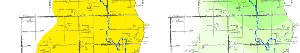
21 Alternative Plan Components Ranking of Areas Based Upon Estimated Average Annual Groundwater Recharge Based Upon Land use Topography Soil water storage Soil permeability Typical rainfall pattern 21


22 Groundwater Recharge Protection Component of the Preliminary Recommended Water Supply Plan 22
23 Water Conservation Measures Envisioned Under the Alternative and Preliminary Recommended Water Supply Plan Base Level Program Providing a 4% reduction in average day demand, and from 6 to 10% reduction in maximum day demand. Utilities using Lake Michigan with none or modest supply infrastructure needs. Intermediate Level Program Providing a 6 to 8% reduction in average day demand, and a 12 to 14% reduction in maximum day demand. Utilities using groundwater supply with no major problems and with supply infrastructure needs or using new surface water supplies with significant infrastructure needs. Advanced Level Program Providing a 10% reduction in average day demand, and an 18% reduction in maximum day demand. Utilities using groundwater supply with aquifer problems and infrastructure needs or using new surface water supplies and return flow required with major infrastructure needs. High Level Program (Evaluated and not included in regional plan recommendations may be considered on a local utility specific basis) Providing a 25 to 35% reduction in average day demand, and a 30 to 50% reduction in maximum day demand Note: All programs would be designed to meet requirements of the Compact and State regulations under development. Additional measures may be applicable if needed to meet sewerage system protection or stormwater management objectives. 23

 Recharge of")
 plus selected agricultural, irrigation, and")
24 Regional Water Supply Plan Alternative Plan 1 Design Year 2035 Forecast Conditions Under Existing Trends and Committed Actions Existing 2007 water supply facilities Enhanced local water conservation programs Continued reliance on groundwater sources to meet 2035 demand (light blue) Continued reliance on Lake Michigan water sources for all areas now served, meeting 2035 demand (dark blue) Recharge of groundwater at new construction sites to the extent required by State law Continued reliance on private wells for residential areas (about 180,000 persons) plus selected agricultural, irrigation, and industrial uses 24

 all with existing return flow (green) 2 areas west of")
 Includes conversion of selected treated deep aquifer sources to")
25 Regional Water Supply Plan Alternative Plan 2 Limited Expansion of Lake Michigan Supply Includes most aspects of Alternative Plan 1, but converts certain areas to Lake Michigan supply 4 areas east of the subcontinental divide (Germantown, Elm Grove, Brookfield-east, and Yorkville) all with existing return flow (green) 2 areas west of the divide (New Berlincentral, Muskego) both straddling communities with existing return flow (green) Includes conversion of selected treated deep aquifer sources to shallow aquifer 25


26 Regional Water Supply Plan Alternative Plan 3 Groundwater Recharge Includes all aspects of Alternative Plan 2 Enhancement of rainfall infiltration over 4.0 square miles of open space through bioengineering; sites to be selected Protection of most significant groundwater recharge areas through public purchase if necessary Recharge of groundwater at new construction sites beyond the extent required in State law Redirection of wastewater treatment plant effluent to shallow aquifer after enhanced treatment at 4 demonstration locations Recharge deep aquifer with treated Lake Michigan water 26
 (green) 4 areas in communities which straddle the divide (Brookfield-west,")
27 Regional Water Supply Plan Alternative Plan 4 Further Expansion of Lake Michigan Supply Includes all aspects of Alternative Plan 2 but with conversion of selected additional areas to Lake Michigan supply all with return flow components 4 areas east of the subcontinental divide (Cedarburg, Grafton, Fredonia, Saukville) (green) 4 areas in communities which straddle the divide (Brookfield-west, Menomonee Falls-west, Brookfield- Town, Union Grove) (green) 9 areas which are in communities west of the divide within a straddling county (Pewaukee-City, Pewaukee- Village, Sussex, portion of the Town of Lisbon, Lannon, Waukesha-City, portions of the Towns of Waukesha, Genessee, and Delafield) (green) 27
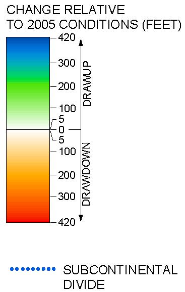

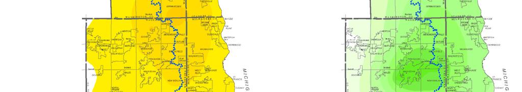

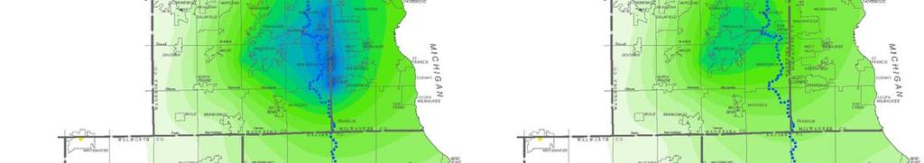
28 Evaluation of Four Alternative Plans Deep Aquifer Conditions Associated with Alternative Water Supply Plans 28
29 Four Alternative Plans Test and Evaluation Results-Summary Capital Costs Annual Operating and Maintenance Cost Equivalent Annual Cost Deep Aquifer Impact Shallow Aquifer Impact Surface Water Impact Alternative Plan 1 $170 million $5.1 million $11.2 million Significant slowdown in the drawdown of the deep aquifer Localized impact around community wells 4.5% reduction in groundwater derived baseflow Alternative Plan 2 $219 million $3.2 million gross -$3.3 million net* $6.2 million Drawup in the deep aquifer Localized impact around community wells 5.3% reduction in groundwater derived baseflow Alternative Plan 3 $367 million $8.6 million gross $2.1 million net* $12.9 million Drawup in the deep aquifer Localized impact around community wells 1.7% reduction in groundwater derived baseflow Alternative Plan 4 $470 million $7.3 million gross -$14.4 million net** $14.3 million Drawup in the deep aquifer Localized impact around community wells 0.7% reduction in groundwater derived baseflow *Includes a credit of $6.5 million for reduced household water softening costs. **Includes a credit of $21.7 million for reduced water softening costs. 29
30 Regional Water Supply Plan Subalternative 1 to the Composite Plan: Enhanced local conservation programs Conversion of selected areas with current return flow to Lake Michigan supply Conversion of selected groundwater supply from deep to shallow aquifer supply Enhancement of rainfall infiltration over 2.0 square miles of open space through bioengineering Continued reliance on private wells for selected residential areas (about 180,000 persons plus selected agricultural, irrigation, and industrial uses) 30

 Includes all aspects of")


31 Regional Water Supply Plan Subalternative 2 to the Composite Plan: (Preliminary Recommended Water Supply Plan) Includes all aspects of subalternative 1 to the composite plan except: The city of Waukesha water utility is converted to a Lake Michigan supply with a return flow component The enhanced rainfall infiltration acreage is reduced from 2.0 to 1.7 square miles 31

32 Options 1 4 for Return Flow for Subalternative 2 to the Composite Plan: Return Flow Pipelines to Lake Michigan, Underwood Creek, and Root River Return Flow Active Management Concept No Return Prior to and During Expected High Flow Periods 15 Percent Excess Return Flow Available Return Flow Amount to Match Water Used 32


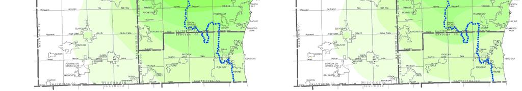
33 Evaluation of Subalternative Composite Plans Deep Aquifer Conditions Associated with Subalternatives of the Composite Plan 33
34 Composite Plans Test and Evaluation Results-Summary Capital Costs Annual Operating and Maintenance Cost Equivalent Annual Cost Deep Aquifer Impact Shallow Aquifer Impact Surface Water Impact Subalternative 1 Composite Plan $276 million $5.4 million gross -$4.0 million net* $9.9 million Drawup in the deep aquifer Localized impact around community wells 3.4% reduction in groundwater derived baseflow Subalternative 2 Composite Plan $324 to 352 million $8.0 to 8.5 million gross -$8.2 to 8.7 million net* $8.2 to 10.5 million Drawup in the deep aquifer Localized impact around community wells 2.0% reduction in groundwater derived baseflow *Includes a credit of $9.4 million for reduced household water softening costs. **Includes a credit of $16.7 million for reduced water softening costs. 34
35 Summary of Plan Findings and Recommendations Water Conservation The level of water conservation to be implemented should be utility-specific based upon the utility infrastructure needs, the characteristics and sustainability of the source of supply, and consistency with the Compact and Federal and State regulations. The level of water demand reduction which might be expected from water conservation programs utility-wide will vary from 4 to 10 percent in average daily demand and from 6 to 18 percent in maximum day demand. For all Milwaukee County communities the recommendations provide for base level water conservation programs providing for about a 4 percent reduction in average daily demand and a 6 to 8 percent reduction in maximum daily demand. Groundwater Recharge The recharge areas within southeastern Wisconsin have been identified and ranked low, moderate, high, and very high with regard to the amount of recharge which occurs on each acre of land. Implementation of the 2035 regional land use plan will result in protection of about 74 percent of the areas ranked as having high recharge and very high recharge characteristics. Careful design of new residential development and the use of selected stormwater management practices would be expected to increase this amount. 35
36 Summary of Plan Findings and Recommendations Water Supply Sources There are viable options which rely on increased use of groundwater as a source of supply for communities located west of the subcontinental divide. The existing Lake Michigan treatment supplies are generally of a high quality and have adequate or excess capacity. Some added capacity would be needed to serve expanded service areas in Ozaukee County and Oak Creek in Milwaukee County. 36
37 Summary of Plan Findings and Recommendations For 59 water utilities the existing sources of supply generally Lake Michigan, the shallow aquifer, or a combination of shallow and deep aquifers underlying the Region were determined to be adequate. Therefore, the plan proposes that these utilities continue to utilize their existing sources of supply with expansion as needed. For four utilities the plan places greater reliance on use of the shallow groundwater aquifer as a source of water supply (Delavan, Elkhorn, Hartford, Bristol). Utility areas expected to change to a Lake Michigan supply over the planning period (to 2035) include - Cedarburg (east of divide) - Grafton (east of divide) - Saukville (east of divide) - Eastern Brookfield (east of divide) - Central New Berlin (straddling community, return flow system already in place) - Elm Grove (east of divide) - Muskego (straddling community, return flow system already in place) - Waukesha (west of divide in straddling county, new return flow system required) - Germantown (east of divide) - Yorkville (east of divide) This plan is being proposed because of its benefits in the drawup of the deep and shallow aquifers, minimizing loss of baseflow in surface waters, and reducing chloride discharges to surface waters. 37
38 Summary of Plan Findings and Recommendations Groundwater pumping in the Region by 2035 is expected to remain about the same as in 2005 about 78 mgd. However, pumping from the shallow aquifer is expected to increase and pumping from the deep aquifer is expected to decrease. The use of Lake Michigan supplies is expected to increase from about 206 mgd in 2005 to 242 mgd in
39 Summary of Plan Findings and Recommendations Recommended high capacity wells siting procedures would involve more site selection and impact analysis, monitoring, and mitigation steps. The cost of the new facilities and programs envisioned in the plan for municipal utilities averages $14 per capita per year, with a range of from under $2 per person in Milwaukee County to over $80 per person in Ozaukee County. The fiscal impact on Milwaukee County residents and businesses would be a net savings when factoring in revenue sales to new customers outside the County. The water table in the deep aquifer in the Region is expected to stabilize or partially recover in most of the Region. The impacts of groundwater pumping on stream baseflow are minimized. 2.0 percent reduction is expected by County specific impacts range from a 14 percent augmentation to a 4.5 percent reduction. 39
40 Summary of Plan Findings and Recommendations Impacts of Preliminary Recommended Plan on Milwaukee County Communities, Residents Existing water treatment supplies are generally of a high quality and have adequate capacity. (In the case of the City of Milwaukee Water Works, considerable excess capacity exists.) No major new infrastructure requirements are envisioned, except at the City of Oak Creek water treatment plant where expansion has long been planned and was found to be needed under all alternative plans evaluated due to planned growth in the areas served by the Utility. An opportunity would be presented to expand the customer base for the Milwaukee Water Works and potentially the City of Oak Creek Water Utility by the addition of customer communities outside of Milwaukee County. This could take advantage of unused water treatment plant capacity in the case of the Milwaukee Water Works treatment plants. Such an increase in customer base should result in a reduction in water rates, all other things being equal. The cost for providing any new conveyance infrastructure needed for new customer communities would be borne by those new customer communities. Return flow options for Waukesha will need careful environmental evaluation as part of plan implementation. Groundwater remains a viable option for Waukesha should the environmental evaluation conclude that Lake Michigan should not be used as a source of supply. 40
41 Regional Water Supply Planning Program Remaining Steps in Planning Process Public informational meetings, outreach, and other activities Complete planning report (recommended plan, implementation, and summary chapters) Estimated Time Frame October 2008 through February 2009 April,