Groundwater Sources, Well Design, and Permitting
|
|
|
- Samuel Preston
- 5 years ago
- Views:
Transcription

1 Groundwater Sources, Well Design, and Permitting March 6, 2018 All About Irrigation Workshop Tidewater Agricultural Research and Extension Center Suffolk, VA Presented by: Curtis Consolvo, P.G. GeoResources, Inc.
2 Permitting Requirements (VA & NC) State-wide in Virginia and North Carolina: Health Department Permit for each well (well driller typically handles). Virginia Groundwater Management Areas (Coastal Plain): Groundwater Withdrawal Permit for total withdrawal (via one or more wells) if > 300,000 gallons in any calendar month. North Carolina: State Well Construction Permit for wells with design capacity > 100,000 gpd. If located in Central Coastal Plain Capacity Use Area (15-county area), registration and reporting requirements start at 10,000 gpd, and Water Use Permit required if > 100,000 gpd.
.")
3 Source: NC DEQ Central Coastal Plain Capacity Use Area website (modified by adding title to right). NC Central Coastal Plain Capacity Use Area
4 VA DEQ Groundwater Management Areas Source: VA DEQ Water Withdrawal Permitting and Compliance website (modified by adding title to right).
5 Source: U.S.G.S. Professional Paper 1731, 2006.
6 Modified from U.S.G.S. Water-Supply Paper 2220, Open-Hole Well (in Bedrock)
 Modified from U.S.G.S. Water-Supply Paper 2220, 1983.")
7 Screen and Gravel-Pack Well (in unconsolidated, Coastal Plain sediments) Modified from U.S.G.S. Water-Supply Paper 2220, 1983.
8 Modified from U.S.G.S. Professional Paper Review 1731, of 2006, Groundwater Plate 5. Resources
9 Modified from U.S.G.S. Professional Paper 1731, 2006, Plate 5.

10 Modified from U.S.G.S. Professional Paper Review 1731, of 2006, Groundwater Plate 5. Resources

11 Modified from U.S.G.S. Professional Paper 1731, 2006, Plate 5. Review of Groundwater Resources

12 Source: U.S.G.S. Professional Paper 1731, 2006, Figure 14.

13 Source: U.S.G.S. Professional Paper 1731, 2006, Figure 18.


14 Hydrogeologic framework information available on-line: VA DEQ Office of Groundwater Characterization And in North Carolina, the NC Division of Water Resources, Groundwater Management Branch is an excellent source of information.
15
16
17 Modified from U.S.G.S. Professional Paper 1731, 2006, Plate 5.
18
19
20 Well depth: 42 feet Water level depths: ~ 13 feet Well depth: 96 feet Water level depths: ~ 22 feet Graphs from data querying/displaying via U.S.G.S. Water Data website for wells 54C 13 SOW 221D and 54C 12 SOW 221C (modified by adding text/numbers to left).
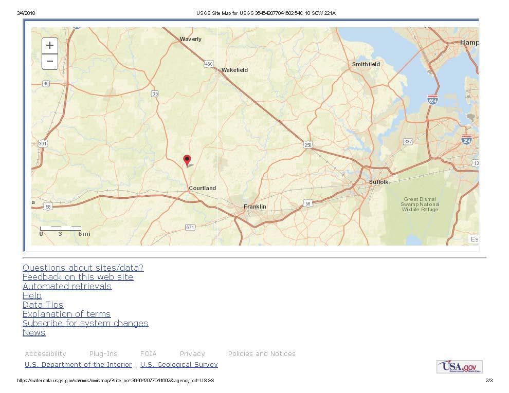
21 Well depth: 178 feet Water level depths (recently): ~ 98 feet Well depth: 537 feet Water level depths (recently): ~ 110 feet Graphs from data querying/displaying via U.S.G.S. Water Data website for wells 54C 11 SOW 221B and 54C 10 SOW 221A (modified by adding text/numbers to left).
22 Modified from U.S.G.S. Professional Paper 1731, 2006, Plate 5.

23 Unconfined versus Confined aquifers In confined aquifers: > water levels represent potentiometric levels; > drawdown impacts are far-reaching and shared. Modified from U.S.G.S. Water-Supply Paper 2220, 1983.

24 Source: U.S.G.S. Water-Supply Paper 2220, 1983.
.")
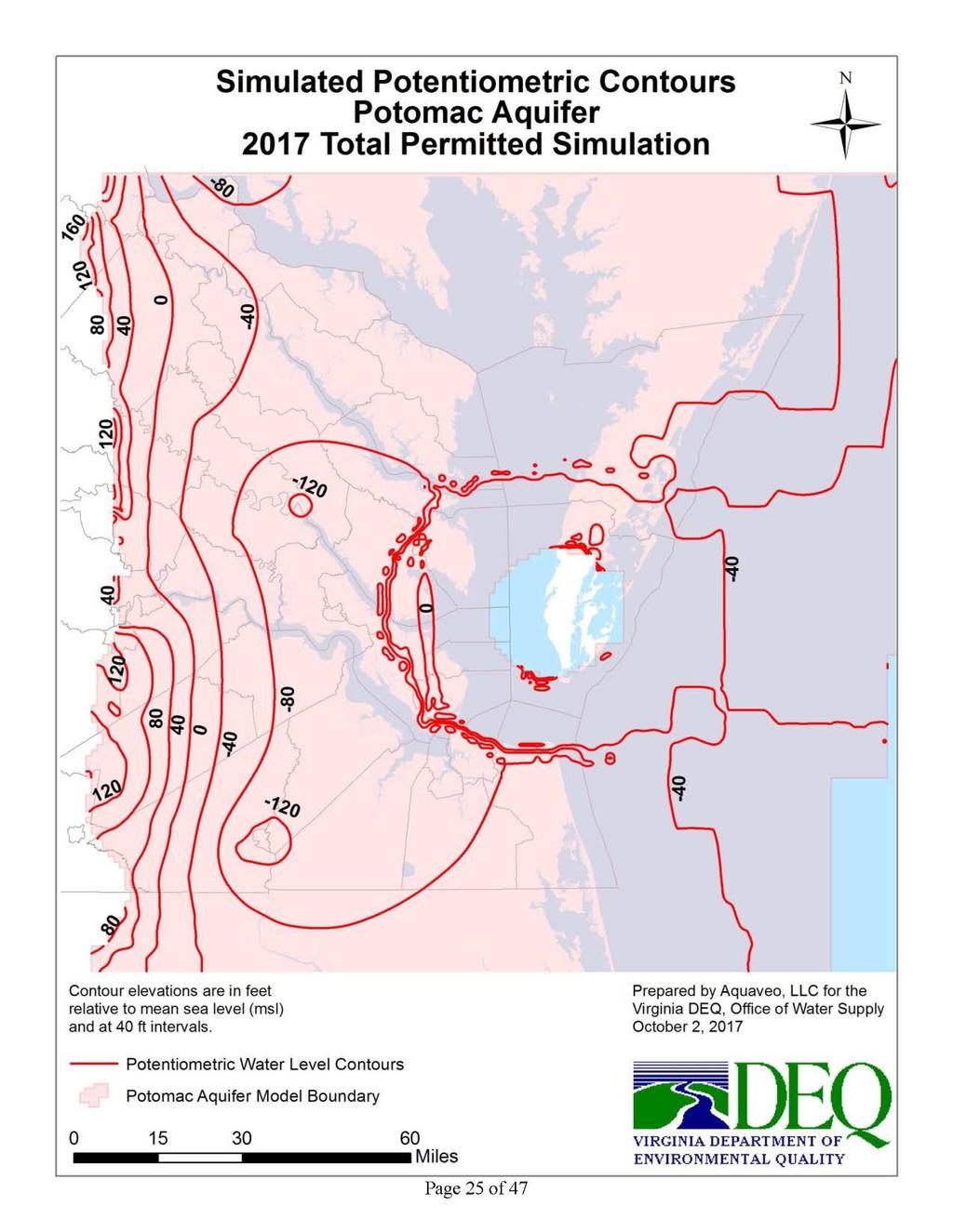
25 Slide provided by T.S. Bruce, VA DEQ Office of Groundwater Characterization, and used with permission (title to right has been modified). Potentiometric Surface Declines in Confined Aquifers of the Coastal Plain

26 Modified from U.S.G.S. Professional Paper 1731, 2006, Plate 5.
27
28
29
30
31
32
33
34
35
36


37 Well depth: 42 feet Water level depths: ~ 13 feet Well depth: 96 feet Water level depths: ~ 22 feet
: ~ 98")
:")
38 Well depth: 178 feet Water level depths (recently): ~ 98 feet Well depth: 537 feet Water level depths (recently): ~ 110 feet

39 Pdf to slide saved as png

40 Pdf to slide saved as png
41 If you re in a VA DEQ Groundwater Management Area and will be using wells (or already are) for > 300,000 gallons in any calendar month, Start the permitting process as soon as possible: It can take years for permits to be issued. Forecast is for enforcement. 300,000 gallons/month isn t much: equivalent to 11 acre inches.
42 Get the DEQ involved BEFORE drilling wells: The DEQ wants to be notified and to make site-specific calls on aquifer depths, grouting and pump setting depth requirements. Avoid costs of meeting requirements after-the-fact. Gain key information for making best well-design decisions: Which aquifer(s) more/less likely to be permitted for withdrawal rates needed; Proximity to permitted withdrawals/permits in progress; Depth limit for pump (rough idea actual determination made from drilling/logging results).
43 Consider the surficial (Columbia) aquifer: Depending on location, can have high yields and good water quality. For example, at a site where coarse sands extend to nearly 80 feet, we re getting 150 gpm from each of two wells, with excellent water quality. Withdrawal impacts minimal (unconfined aquifer). The VA DEQ is considering a fast-track permitting process for groundwater withdrawals from the surficial aquifer.
44 If you need a Groundwater Withdrawal Permit and your wells are already constructed.. In the past (from my experiences), requirements have included/ranged from: Pulling pumps to confirm depths (and raising if necessary), running down-hole camera, and geophysical logging (inside well via EM-induction); Drilling borehole next to well(s) for drill logging, obtaining samples (of drilling returns), and geophysical logging; Permit issued with condition requiring replacement of well(s) within the term of the permit. Going forward, requirements will include?
45 Summary Recommendations: In the Coastal Plain, you ve got choices when it comes to the source of your groundwater supply. Make that choice with the DEQ on-board and in light of their input to streamline requirements and help ensure a viable (and sustainable) supply. And if already using groundwater above limits without a permit, contacting DEQ sooner probably better than later.

46 Review of Groundwater Resources