Canandaigua Lake Watershed Program Partners in Watershed Protection
|
|
|
- Allen Price
- 5 years ago
- Views:
Transcription

1 Canandaigua Lake Watershed Program Partners in Watershed Protection 5 PROTECTION THEMES Research Education Restoration Open Space Protection Regulation Canandaigua Lake Watershed Association Canandaigua Lake Watershed Council Canandaigua Lake Watershed Commission ****Along with the individual municipalities and numerous county, state and federal agencies and land trusts.

 Subwatersheds: 34 Estimated Total Length of Tributaries: 350 miles")
2 Lake Length: miles Average Width: 1.1 miles Canandaigua Lake Watershed Facts Maximum Depth: 276 feet Surface area of Lake: 10,550 acres Watershed Land Area: 109,000 acres or 174 sq. miles Volume: 429 billion gallons Hydraulic Retention Time: 13.4 years DEC Water Quality Classification: AA, TS Shoreline Length: 36 miles (97% privately owned) Subwatersheds: 34 Estimated Total Length of Tributaries: 350 miles Over $1 billion in shoreline assessed value some areas $11,000/ft of shoreline Major Municipalities within Watershed: 12 Water Purveyors: 6 (City of Canandaigua, Palmyra, Newark, Gorham, Rushville and Bristol Harbor)- 70,000+ people use it as a water supply

3 Finger Lakes Region
4 What will be our Legacy?? In the next years will we see increasing phosphorus levels, algae blooms, aquatic weed growth, beach closures, increased water filtration costs, more invasive species and a whole host of other problems? Cost effective program to promote and protect our Natural Capital and the resulting ecosystem services that are provided It is never the one issue or one source that will cause this lake to be substantially impacted and it is not the one protection theme or one group that will provide comprehensive protection.

5 Tonight s Expert Panel Dr. Greg Boyer - Director of the Great Lakes Research Consortium, and Professor at the State University of New York College of Environmental Science and Forestry Dr. Boyer has done extensive research on biologically active natural products produced by algae. As Director of the Great Lakes Research Consortium, he works with affiliates in NYS and Canada on all aspects of Great Lakes science, policy, and ecology Scott Kishbaugh, P.E. - Chief, Lake Monitoring and Assessment Section, NYS Department of Conservation Division of Water Scott has expertise in Blue Green Algae blooms through his work for the NYS DEC. He is also the Program Director for the Citizen's Statewide Lake Assessment Program (CSLAP), which is a volunteer-based lake monitoring program across NYS that focuses on eutrophication indicators. Dr. Bruce Gilman Professor at Finger Lakes Community College in the Department of Environmental Conservation & Horticulture Dr. Gilman has been conducting water quality monitoring on Canandaigua Lake for over 20 years and has an extensive knowledge of long term water quality trends on the lake.

6 Overview of tonight s discussion 1. Kevin Olvany- Recap of the 2015 Blue Green Algae Bloom 2. Dr. Greg Boyer- SUNY ESF- will review the science behind Harmful Algal Blooms 3. Scott Kishbaugh P.E.- NYS Blue Green Algae Program and Canandaigua Lake 4. Kevin Olvany- Review Watershed Protection Strategies 5. Extensive Question and Answer period This How did the Lake go from to That!

7 mean mean (without WR) Monthly Chlorophyll-a readings Station chlorophyll "a" (ug/l) 28-Apr May Jun Jul Aug Sep-15 Fallbrook Hope Point Deep Run Seneca Point Vine Valley West River
8 9/1/15 7:10 pm Mid Lake- 1, 000 south of boat buoys- Kershaw Mid Lake- just north Yacht Club Location Total chlorophyll Blue green chlorophyll Microcystin-LR levels Middle of the lake about 1000 feet south 15 ug/l 8 ug/l no data of the buoy markers for the boats to go 5 mph (about ½ mile from Kershaw Beach) Middle of the lake just north of the Yacht Club in a surface streak of algae 46 ug/l 39 ug/l 16.7 ug/l Toxin Results received on Sept 8th


9 9/3/15 5:41 pm Cottage City Area- isolated cove conditions Sample Location Total Chlorophyll-a (ug/l) Cottage City Shore 6 pm Deep Run Beach - pm Deep Run Beach (9 am) September 4th 3.23
10 9/4/15 1:49 pm Sample Location Total Chlorophyll-a (ug/l) Canandaigua Water Treatment Plant 500 feet from shore 5.75 Yacht Club Mid Lake Squaw Island East Side, 200 feet from the island 4.33 Kershaw Beach 1000 feet from shore, in the boat area 5.17 Tichner Point North side of point, 100 feet from shore 6.44 Menteth Creek Mid-lake, ½ mile north of the creek 7.46 Onanda Beach 300 feet from the ropes 7.43 Rushville Plant 200 feet offshore 6.56 Pelican Point 1000 feet south of the point, 200 feet from shore mile north of Deep Run, 300 feet from shore yards off shore, just north of Tichenor Point- 2:15pm Mid lake off of the Yacht Club
. This is about ½ mile from the intake pipes for the City.")


11 9/8/15 1:15 pm- Just north of School House Beach (Butler Beach) Location High density bloom area along the west shore- Butler Road Beach (see picture). This is about ½ mile from the intake pipes for the City. City Dock at the north end of the lake; very close proximity (300 feet) from where the swimmers will be for the triathlon; about 200 feet from shore Raw water sample from the City water treatment plant in order to see if any toxin is making it to the intake pipes. 9/9/15 2:03 pm Total chlorophyll Blue green algae chlorophyll Microcystins Concentration 205 ug/l total 192 ug/l Bloom 40.9 ug/l - High toxicity 2.6 ug/l total 1.6 ug/l 0.3 ug/l - Low toxicity 1.5 ug/l total 0.7 ug/l total nd (<0.4 ug/l)* - Minimal
 1.")
 1.")
12 9/10/15 8:28 am sample point Location Total chlorophyll Blue green algae chlorophyll Microcystins Concentration Triathlon #1 - End of Swim Course 2.5 ug/l total 0. ug/l (low) 1.14 ug/l moderate toxicity Triathlon #2 - Middle Course Buoys 2.73 ug/l total 1.05 ug/l (low) 1.03 ug/l moderate toxicity Triathlon #3-100 yds from Shore ug/l total 8.69 ug/l total (medium) 1.40 ug/l moderate toxicity Middle of the lake, end of the triathlon course


13 9/10/15 2:16 pm Poplar Beach

14 9/11/15 9:35 am Kershaw Park City Dock


15 9/11/15 9:50 am Poplar Beach


16 9/11/15 11:43 am Large foam streak that can be seen from 4 miles away
17 9/15/15 3:18 pm 1000 feet from shore off of Onalinda Drive
18 9/15/15 3:24 pm Crystal Beach Area ¼ mile off of shore

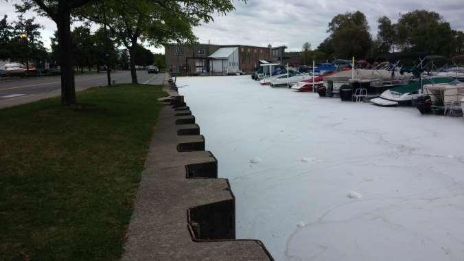
19 9/15/15 4:07 pm North end of the lake (foam glaciers)

20 9/15/15 3:06 pm ½ mile from shore off of Onalinda Drive


21 9/16/15 11:05 am Kershaw Park


22 9/16/15 2:03 pm Kershaw Park


23 9/16/15 2:07 pm Kershaw walking bridge at the Canandaigua Lake/Outlet interface


24 9/17/15 11:47 am Kershaw Park


25 9/17/2015- afternoon Photos taken by Keith Cutri Thanks Keith!
26
27


28 Kershaw- 9/21-9:46am City Pier- 9/21-10:01am Location Total chlorophyll Blue green algae chlorophyll Microcystins Concentration City Pier- easterly wind pattern accumulating algae along the east side of Pier 12.4 ug/l total 6.3 ug/l Medium 3.5ug/L moderate toxicity City Dock at the north end of the lake; 3.6 ug/l total 1.7 ug/l - Low 1.2ug/L moderate toxicity

29 City Pier- 9/22-8:06am

30 9/22- Mid Lake- Yacht Club- 3:09pm City Dock- 12:27pm 9/22- Mid Lake- Water Treatment Plant 3:05pm

31 Picture taken from Foster Road- Retreat House- 9/23-11:39am


32 9/24/15 12:50 pm Mid-lake across from the Yacht Club Small isolated bloom located just south of Menteth Point -County Road 16 Location Total chlorophyll Blue green algae chlorophyll Microcystins Concentration Onanda Fishing Pier 2.1 ug/l total 0.6 ug/l - medium 0.3 ug/l minimal toxicity Small isolated area with concentrated bloom just south of Menteth Point 94 ug/l 83 ug/l - Bloom 17.6 ug/l high toxicity Mid-lake Yacht Club 7.1 ug/l total 3.7 ug/l - medium 1.75 ug/l moderate toxicity
33 Watershed Management Categories 1. New and Existing Development 2. Lawn and Landscaping Practices 3. Municipal Roads and Highway Facilities 4. Stream and Shoreline Management 5. Wetlands and Floodplains 6. Wastewater Management 7. Agriculture 8. In-Lake Issues: Invasive Species, Harmful Algal Blooms and Fish Kill Management 9. Recreation 10. Lake Level Management 11. Forestry 12. Mining and Natural Gas Extraction 13. Chemical Contamination Prevention


34 Tributary Water Quality Monitoring Seventeen tributary streams were monitored (grab samples) during 55 storm/melt events between 1997 and 2014.


35 North End Plume from Fall Brook Stream- 6/6/15-2:45pm

36 Google Maps- Summer 2015 South End Plumes


37 Enhanced Water Quality Monitoring Continue and Enhance the tributary monitoring program Measure density and age classification of Quagga and Zebra Mussels Blue green algae sensor for upgraded water quality monitoring probe Allows for immediate results on blue green algae concentrations (cells/ml) The Watershed Council, Association and FLCC have partnered to purchase the new probe Long Term may apply for additional funding for a water quality buoy- real time data


38 Existing and New Development 1. Increase municipal management of stormwater 2. Encourage local-level comprehensive land use planning 3. Expand green infrastructure and low impact development


39 New Development in the Town of Canandaigua


40 Lawn and Landscape Practices 1. Improve educational programs on fertilizer and pesticide use. 2. Monitor streams and lake for nutrients and pesticides Photo from the Klamath River, California Source:


41 Streambank and Shoreline protection 1. Monitor streambanks and shorelines for erosion and lack of buffers 2. Protect, restore and stabilize streamside areas 3. Protect shoreline areas through enhanced regulations


42 Wetland and Floodplain Management 1. Protect, restore and create wetlands and floodplains 2. Expand floodplain regulations


43 Wastewater Management 1. Encourage municipalities to strengthen onsite wastewater system rules and regulations 2. Maintain Digital/Mapped Database of onsite systems 3. Educate Landowners on proper maintenance 4. Extend sewers where appropriate


44 Agricultural Management 1. Promote, partner and enhance the programs offered by Soil and Water and NRCS. 2. Promote buffers between Ag Lands and streams/road side ditches 3. Increase the size and capabilities of wetlands downstream of Ag Lands to reduce flooding and improve water quality 4. Utilize Local funding and private contributions to partner with farmers to make the necessary changes to adapt to the severe weather conditions that have become the norm.


45


46 Invasive Species Management 1. Establish an early detection and rapid response protocol for invasive species 2. Prevent the spread of invasive species from recreation 2A. Promote the local funding of the Watercraft Steward Program and advocate for continued state funding.


47 Funding for Monitoring and Watershed Management Municipalities provide base funding for Watershed Council and Commission Membership contributions by citizens towatershed Association The Watershed Council applied for project funding through the CFA application in NYS Three potential funding sources: NYS DEC, NYS Department of State, and NYS Environmental Facilities Corp
48 What will be our Legacy?? In the next years will we see increasing phosphorus levels, algae blooms, aquatic weed growth, beach closures, increased water filtration costs, more invasive species and a whole host of other problems? Cost effective program to promote and protect our Natural Capital and the resulting ecosystem services that are provided It is never the one issue or one source that will cause this lake to be substantially impacted and it is not the one protection theme or one group that will provide comprehensive protection.