The Deepwater Horizon Oil Spill: What can we learn from this disaster?
|
|
|
- Christopher Dean
- 5 years ago
- Views:
Transcription
1 LIVE INTERACTIVE YOUR DESKTOP The Deepwater Horizon Oil Spill: What can we learn from this disaster? Presented by: Audra Livergood, Will Underwood and Atziri Ibanez February 2, :30 p.m. 8:00 p.m. Eastern time


2 Your Presenters Audra Livergood, Marine Resource Manager, NOAA Fisheries Will Underwood, Stewardship Coordinator, Grand Bay NERR Atziri Ibañez, NERRS National Education Coordinator
3 What is an estuary? What are some examples of estuaries along the Gulf Coast? PART ONE

4 Poll Question What is an estuary? a. The land area that drains water into a lake, river, or pond. b. The large body of salt water that covers most of the earth's surface. c. The area where a river meets the ocean, where fresh and salt water mix. d. The underground system that provides drinking water to an area. 4


5 Deepwater Horizon oil spill On April 20, 2010 an explosion rocked the oil drilling platform.


6 6


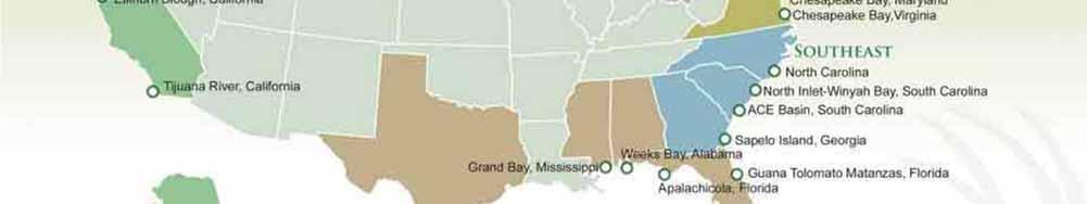
7 Five key estuaries in danger of being impacted by the oil spill 7 7


8 Mission Aransas NERR (Texas) MANERR Has the only naturally migrating population of whooping cranes in the world Total Acreage: 185,708 Designation: 2006 Weeks Bay NERR Provide habitat for rare and endangered species including the brown pelican, eastern indigo snake, and the Alabama redbellied turtle. Total Acreage: 6,525 Designation: 1986 Weeks Bay NERR (Alabama)


9 Apalachicola NERR (Florida) Apalachicola NERR The West Indian manatee, the Indiana bat and the gray bat are endangered species that make their home at the Reserve Total Acreage: 246,000 Designation: 1979 Rookery Bay NERR (Florida) Rookery Bay NERR Is a prime example of a nearly pristine subtropical mangrove forested estuary Total Acreage: 110,000 Designation: 1978


10 10 10
11 How many class or activity periods of estuary instruction do your students receive in a typical school year? [Place clip art on the continuum below] More than 15 classes per year 6 to 15 classes per year 3 to 5 classes per year 1 to 2 classes per year None


12 Resources 1 Your Source for Learning and Teaching About Estuaries Video Gallery Estuaries 101 Curriculum Access to real-time data with graphing capabilities Species Factsheets
13 Let s pause for questions 13
14 Where and what is the Grand Bay Reserve? PART TWO


15 About Grand Bay NERR (MS) Approximately 18,000 acres (28 sq. mi.) of emergent marsh, pine flatwoods, and pine savannas Established in 1999 Represents the Louisianian bio-geographic region 15


16 Grand Bay is located in the Northern Gulf of Mexico to the east of the Mississippi river


17 The drilling site was approximately 150 miles SSW of the Grand Bay NERR


18 Mobile delta area often influence the waters of the Grand Bay NERR


19 Grand Bay Reserve boundary Bayou Heron Bayou Cumbest


20 How were the Grand Bay marshes formed? Where rivers meet the sea? Currently little freshwater input from uplands Pre-historic origin of marshes formed by Pascagoula and Escatawpa Rivers 20


21 What makes Grand Bay important? Marshes serve as nursery ground Provides protection from dangerous storm surge Marshes filter nutrients Commercial and recreational fishing Outdoor recreation 21


22 Natural & Anthropogenic Stressors Hurricanes Erosion Invasive species Loss of sediments through dredging Decreased air and water quality Industrial disasters Overharvest of fishery 22


23 Mississippi Phosphates Spill


24 Estuaries 101 Curriculum 24
25 What can we learn from ongoing monitoring at the Grand Bay Reserve? PART THREE


26 System-Wide Monitoring Program Observing short term variability and long term changes in estuarine environments I. Abiotic Monitoring Water Quality & Nutrients Weather Parameters II. Biological Monitoring Habitat Change Biodiversity III. Land Cover/Use and Habitat Change Spatial Patterns Human Impacts


27 Monitoring Water Quality & Weather Data SWMP Data logger Water quality data is collected at 15 or 30 minute intervals at 4 locations within or adjacent to a research reserve. Weather data is collected within or adjacent to a research reserve at 5 second intervals.


28 Mapping, Monitoring, Research Critical for protection of natural resource Primary responsibility of research and stewardship staff in the reserve system Provides baseline information important in assessing damage from disasters 28


29 Fine-Scale Marsh Habitat Delineation


30 Sea Grass Communities at GBNERR 30


31 Resources 2 Data in the Classroom Three curriculum modules: El Nino, Sea Level & Water Quality Grades 6-8 Downloadable materials Correlated to National Standards in Science, Mathematics, Geography & the Ocean Literacy Concepts
32 Let s pause for questions 32
33 How did the oil spill and the response effect the Grand Bay Reserve? PART FOUR


34 Sequence of Events Rig explosion, 4/20 Booming initiated, 5/4 1 st rig debris/tarballs, 6/4 1 st oil at reserve, 6/12 Temporary cap installed, 7/15 Targeted boom removal, 8/31 Response ongoing 34
35 Plan for the Worst Identify Critical Resources Review Existing Response Plans Prioritize Critical Areas Limited Response Resource Identify Areas Sensitive to Response Damage Learn and Adapt to Incident Command System Begin Collecting Baseline Samples Provide Site Specific Technical Support 35


36 Contingency Plan outlines booming needed


37 Extensive pre-oil samples were collected 37
38 Poll Question Based on their research, scientists have learned that it is always preferable to clean up an oiled salt marsh as opposed to simply leaving it alone to recover naturally. True X False 38


39 Installing booming is a delicate process in shallow waters


40 Airboats were used to install boom


41 Three types of boom were installed Pom-pom boom Hard boom


42 Waiting for the Worst


43 Signs of the spill on GBNERR appeared as debris


44 Dispersed oil at GBNERR


45 Oiled boom at GBNERR


46 Large patches of oil were stranded on the GBNERR marshes


47 Storm events had a damaging effect on boom


48 Understanding key features of an estuary key to protecting it
49 Poll Question Which of the following factors may help the Gulf of Mexico to recover from the BP oil spill more quickly than did Prince William Sound after the Exxon Valdez spill? Warmer water temperature Presence of natural oil eating microbes Chemical composition of the crude spilled None of the factors listed All of the factors here listed 49


50 What is NRDA? Natural Resource Damage Assessment A legal process to determine - Injuries to or lost use of the public s natural resources - Appropriate amount & type of restoration needed to offset losses NERR staff involved in technical working groups 50


51


52 How do we clean up oil at Grand Bay? In most cases, clean up is not recommended in Juncus marshes Mechanical cleanup methods might harm sensitive habitats Environmental stewardship Important concept for students to understand and practice 52


53 Opportunities for Restoration 53
 sediment testing Continue monitoring natural resources Analyze trends in resource abundance")
54 Long-Term Monitoring Continue shoreline assessment work to look for stranded oil PAH (polycyclic aromatic hydrocarbons) sediment testing Continue monitoring natural resources Analyze trends in resource abundance 54
55 Take Home Message Estuaries can serve as the nexus for teaching earth, life, and physical sciences Extensive research, mapping, and monitoring are necessary to analyze short and long-term changes/impacts from the oil spill Applying lessons learned, in terms of planning and response to past oil spills, can help better prepare our future leaders Understanding the impacts of the oil spill is a continuous process that will require direct observation and analysis of key archived and real-time data 55

56 Let s pause for questions 56
57 Where can I find educational resources about estuaries and the oil spill? PART FIVE
58 Teacher Professional Development Opportunities Visit the Estuaries.Gov site to find teacher training opportunities Sign-Up to receive the NERRS Education Bulletin We will announce upcoming opportunities Help Field Test the Estuaries 101 Middle Grade Curriculum At the end of 2011 we will form a team of reviewers who will test the activities 58


59 Resources 3 Oil Spill Educational Resources Multimedia Animation Lessons and Activities Real World Data Background Information Career Profiles
60 Thank you! For more information: Re: Estuaries in the National Estuarine Research Reserve System Contact: Atziri Ibanez Learn more: NOAA Deepwater Horizon Archive 60


61 Thank you to the sponsor of tonight's Web Seminar:


62


63

64 National Science Teachers Association Dr. Francis Q. Eberle, Executive Director Zipporah Miller, Associate Executive Director Conferences and Programs Al Byers, Assistant Executive Director e Learning NSTA Web Seminars Paul Tingler, Director Jeff Layman, Technical Coordinator LIVE INTERACTIVE YOUR DESKTOP