Office of Water Supply Groundwater Withdrawal Permitting Program
|
|
|
- Cori Parker
- 5 years ago
- Views:
Transcription


1 Office of Water Supply Groundwater Withdrawal Permitting Program
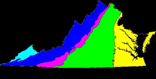

2 Virginia Physiographic Provinces COASTAL PLAIN
3 Coastal Plain Aquifer System UNCONFINED AQUIFER (Water Table) CONFINING UNITS WEST CONFINED AQUIFERS EAST

4 Coastal Plain Aquifer System
5 Decision Making Framework Legacy of Research Regulatory Actions Expansion of GWMA Virginia Coastal Plain Groundwater Initiative


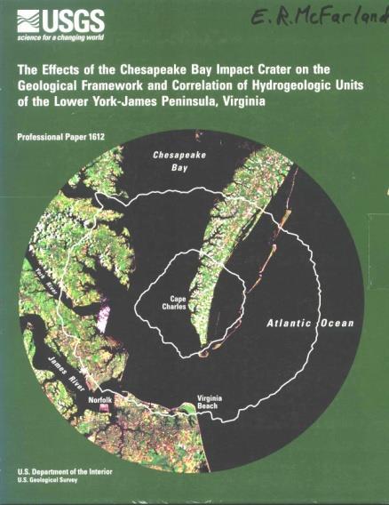


6 Legacy of Research

7
8 Regulatory Actions Virginia Well Capping Law (1956) Ground Water Management Act of Amendments to the GWM Act of 1973 Ground Water Management Act of 1992 (Chapter 25 of Title )
9 Ground Water Management Act Findings and purpose. the right to reasonable control of all ground water resources within this Commonwealth belongs to the public and that in order to conserve, protect, and beneficially utilize the groundwater of this Commonwealth and to ensure the public welfare, safety and health, provision for management and control of ground water resources is essential.
10 Groundwater Management Areas (GWMA) Protects existing users from new or expanding withdrawals. Assures continued resource viability into the future. Manages the resource comprehensively.

11 CUMULATIVE COMPACTION (mm) CUMULATIVE COMPACTION (mm) Groundwater Trends in Virginia
12 Expansion of a GWMA Criteria Groundwater levels in the area are declining or are expected to decline excessively; The wells of two or more groundwater users within the area are interfering or may reasonably be expected to interfere substantially with one another; The available groundwater supply has been or may be overdrawn; or The groundwater in the area has been or may become polluted.

13 Declining Water Levels Northern Neck Middle Peninsula


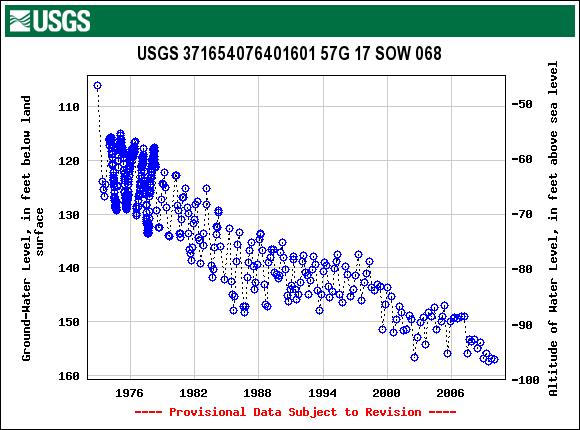
14 Groundwater levels in the area are declining or are expected to decline excessively

15
16 Well Interference Current withdrawals impact much of the entire undesignated region Historic pumping from other uses in Northern Neck and Middle Peninsula are likely to have smaller cones of depression that interfere with current permittee s cones of depression Current monitoring is insufficient to characterize the extent

17
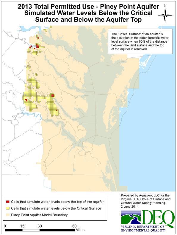
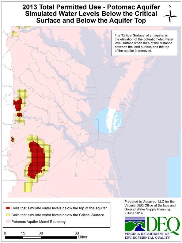
18 Supply May Be Overdrawn Legend Available Storage Used PCT_USED Head Below Unit Top Values >1 indicate head is below the 80% criterion Simulated Change in Storage of Water in the Potomac Aquifer from Pre-development to 2008
19 Supply May Become Polluted Southern Lancaster, eastern Middlesex, eastern Gloucester, Mathews all have chloride concentration issues resulting from salt water intrusion. Not enough information at this time in other parts of the area
20 McFarland, 2010, USGS Professional Paper 1772 Saltwater Intrusion Changes in Water Quality

21 Eastern Virginia GWMA Counties: Caroline Gloucester King and Queen Mathews Northumberland Westmoreland Essex King George Lancaster Middlesex Richmond * Only those portions east of I-95 are included for* Stafford Prince William Fairfax Spotsylvania
22 Regulatory Actions NOIRA July 2009 Advisory Committee Governor s Review Completed - Sept/Oct 2013 Regulations became Effective January 1, 2014 Resulted in Revised Groundwater Withdrawal Regulations Expansion of the Eastern Virginia Groundwater Management Area

23 The January 1, 2014, expansion include the Northern Neck and Middle Peninsula
24 Who did this affect? Persons or entities located within a the expanded area Existing Users Any person or entity that has withdrawn 300,000 gallons or more of groundwater in any one month prior to January 1, New and Expanded Users Any person or entity that plans to modify an existing withdrawal or intends to create a new withdraw 300,000 gallons or more of groundwater in any one month.
25 Existing Users Is an existing user Grandfathered? The regulations allow for an existing user to apply for a permit based on historic use for the first 10 year permit term. This initial permits application is less burdensome and is less expensive to acquire.
26 Special Conditions Permits will include various conditions (in accordance with the regulations) to assist in future permitting and to help manage future costs, time and resources for applicants.
27 New or Expanded Users Information / tasks required for complete application: Water Use Reporting values or estimated water use amount Completes well construction information for all wells VDH Waterworks Operation Permit if a PWS Geophysical Investigations (ex: aquifer test, pump test, camera survey etc) Water Conservation & Management Plan Mitigation Plan applies to AOIs Local Governing Body Approval Alternatives Analysis Justification of Future Need Install water meters
28 Draft Permits & Facilitation Permitting is a joint effort (DEQ/Applicant) Reach goals and ensure permits effectively promote and can accomplish : Reducing Use Raising Pumps Gaining Access to Alternate Sources Implementing more stringent Water Conservation measures Replacing wells (Construction) Installing observations wells or conducting studies Being fully prepared for permit renewal
29 Expansion Update Resulted in: Public Outreach and Community Pre-Application Meetings Receipt of 123 Applications Hiring of additions FTE s for permit processing Current Status 100% of Existing Users applications have been reviewed Notification of Deficiency Letters mailed Will begin issuing Existing User Permits Spring-Summer 2015
30 County Existing User Applications No# of Applicants Caroline 13 Essex 9 Fairfax 6 Gloucester 4 King & Queen 4 King George 16 Lancaster 12 Middlesex 11 Northumberland 22 Prince William 1 Richmond 5 Spotsylvania 2 Stafford 1 Westmorland 17
31 Revisit - Ground Water Management Act Criteria for issuance of permits. In no case shall a permit be issued for more ground water than can be applied to the proposed beneficial use. In evaluating permit applications, the Board shall ensure that the maximum possible safe supply of ground water will be preserved and protected for all other beneficial uses. DEQ s Goal To protect the aquifer and provide for current and future water needs of the public in the Commonwealth DEQ Perspective Need a Virginia Coastal Plain wide Groundwater Initiative
32 Virginia Coastal Plain Groundwater Initiative Initial Steps Taken: Updated Groundwater Model (VAHydro-GW) DEQ conducted groundwater optimization evaluations Investigation of the Economic Impacts of Coastal Plain Aquifer Depletion and Actions that may be needed to Maintain Long-term Availability and Productivity (VT Report) Conducted Virginia Coastal Plain Groundwater Initiative Meeting with top 14 users DEQ correspondence to Water Commission 2015 Legislative actions
33


34

35
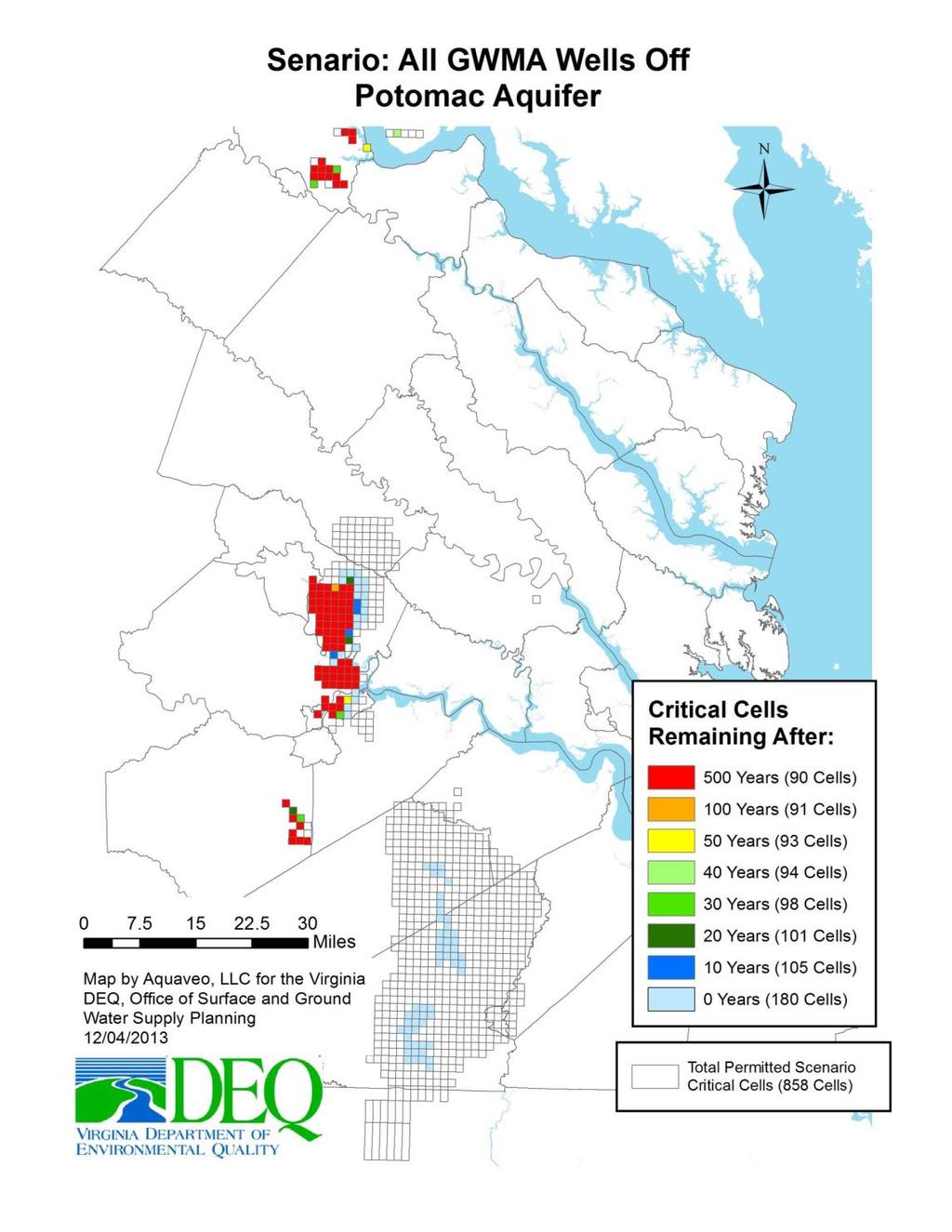
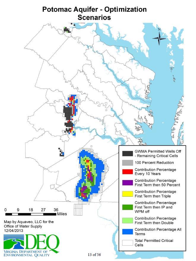
36 Results
37 Results

38
39 Expected Results Restoration of areas with groundwater levels below regulatory standards Permitted withdrawals will be at mgd and unregulated withdrawals estimated at mgd Gains from the reductions will be lost without addressing expected growth in unregulated sector
40 Path Forward Reduce current permitted use Identified potential permitting solutions Reductions expected to stabilize groundwater level declines by users permitted for 87% of withdrawal Impacts actual use of 3 permittees Individual reduction targets discussed with each permittee requested that they provide a 10 year reduction plan for what they can achieve Goal is to issue all remaining permits by end of 2015
41 Caveats Stabilizing the system cannot be achieved without reductions Reductions slow declines and lay ground work for long term solutions Need comprehensive strategy to provide for future growth and development Some present capacity continues to be available in upper aquifers and in the northeastern portion of the coastal plain
42 Next Steps Reduce current permitted use Evaluate alternatives Conservation Reuse Desalination Legislation
43 Craig R. Nicol Manager, Groundwater Withdrawal Permitting Program Office of Water Supply Department of Environmental Quality P.O. Box 1105 Richmond, VA
44 Water levels continue to decline in the primary aquifers. Land is subsiding. Salt water intrusion is occurring. Primary aquifers are not being pumped sustainably.