Characterizing Groundwater and Surface- Water Interactions in Selected Northeast Twin Cities Lakes
|
|
|
- Lorraine Holmes
- 5 years ago
- Views:
Transcription


1 Characterizing Groundwater and Surface- Water Interactions in Selected Northeast Twin Cities Lakes Chapter A: Statistical Analysis and Field Study Chapter B: Groundwater-Flow Simulation Perry M. Jones, Jared J. Trost, Jason L. Roth, Aliesha Diekoff, Daniel Morel, and Melinda L. Erickson U.S. Department of the Interior U.S. Geological Survey
2 Background: 2013 Minnesota Legislation Chapter 137, Article 2, Section 9(b) with the United States Geological Survey to investigate groundwater and surface-water interaction in and around White Bear Lake and surrounding northeast metropolitan lakes, including seepage rate determinations, water quality of groundwater and surface water, isotope analyses, lake level analyses, water balance determination, and creation of a calibrated groundwater-flow model, including a comparison of water levels with lakes bordering the study area. The council shall use the results to prepare guidance for other areas to use in addressing groundwater and surface water interaction issues.

3 General Lake Water Budget Precipitation Plant Transpiration Evaporation Well Surface-water Runoff
 can explain lake-level variations Long-term (1925-2014) analysis Evaluate temporal relations between precipitation and lake")
4 Statistical Analysis of Lake Levels - Objectives Short-term ( ) analysis - Assess lake-level fluctuations across region - Determine if climatic, landscape, or geologic characteristics (40 variables) can explain lake-level variations Long-term ( ) analysis Evaluate temporal relations between precipitation and lake levels
 Short and long-term Study")
5 Statistical Lake-Level Analysis Short-term ( ) 96 lakes Long-term ( ) 14 lakes Selected based on lake-level data Short-term ( ) Short and long-term Study Area


6 Lake-level variability based on lake type Closed-basin Lake no active surfacewater outlet Turtle Lake Flow-through Lake active surface-water outlet Pleasant Lake Outflow


7 Lake levels more stable in urbanized Rural areas Urbanized most urban lakes are flowthrough most rural lakes are closed-basin


8 Closed-basin lake levels declined more at higher elevations similar to groundwater levels


9 Closed- basin lakes water levels more variable at high elevations, in Superior Lobe deposits Des Moines Lobe Deposits Superior Lobe Deposits
10 Long-term analysis ( ) White Bear Lake most variable level Range in annual lakelevel anomalies- 14 lakes White Bear Lake Valentine Lake Precip, 5-yr moving average Annual lake-level anomaly = mean annual lake level long-term mean


11 Variables Affecting Lake-level Variability Lake type (flow-through/closed-basin) Elevation Development (urban and rural) Glacial geology
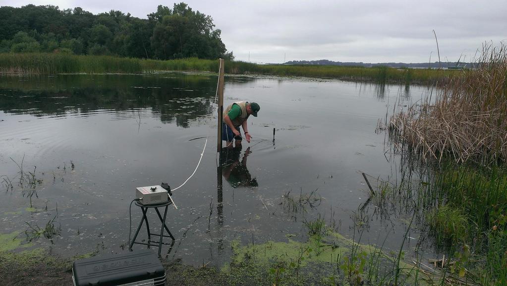
 White Bear Lake Shallow and Deep waters 1) Lake-sediment Coring 2) Water Levels Deep-water Piezometers 3) Seepage-Flux Measurements")
12 Field Assessment of Groundwater and Surface- Water Interactions Water-quality Analyses Stable Isotope/Agedating Continuous Seismic-Reflection (6 lakes) White Bear Lake Shallow and Deep waters 1) Lake-sediment Coring 2) Water Levels Deep-water Piezometers 3) Seepage-Flux Measurements
 White Bear Lake Percentage of Contribution Groundwater Surface water General Groundwater Flow Direction")
13 Surface-water contribution Stable Isotopes Sampled 40 wells October 2014 Prairie du Chien Group / Jordan Sandstone (PDCJ) White Bear Lake Percentage of Contribution Groundwater Surface water General Groundwater Flow Direction (PDCJ)


14 Water-borne Geophysical Survey Continuous Seismic Reflection Determine subsurface structure and geology below lake bottom Conducted in November 2013 White Bear, Turtle, Pleasant, South School Section, Big Marine, and Lake Elmo Towfish with cables


15 White Bear Lake Deepwater Piezometer Nests Ice in/out Ice formation/thaw


16 White Bear Lake Lake Sediment No trapped gases P1 Trapped gases P2 Clays, silts, sands Organic Sediments Organic Sediments Trapped Gases
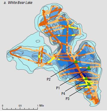
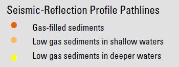
17 Continuous Seismic-Reflection White Bear Lake Turtle Lake


18 White Bear Lake Lake and Piezometer Water Levels, 2014 Nest P1 Nest P3
 lake water outflow 0.04 1.")

19 Seepage-Flux Measurements 2014 Deep water (P1-P4) (March) lake water outflow in/day Nearshore (August) groundwater inflow in/day Seepage Flux in/day
20 Field Assessment - Results Stable isotope ratios - a mixture of surface water and groundwater is reaching Prairie du Chein aquifer in part of NE TMCA Interactions in White Bear Lake - Nearshore: Groundwater flows into lake - Deepwater: Lake water flows into sediments - Seepage flow rates: Nearshore > Deepwater
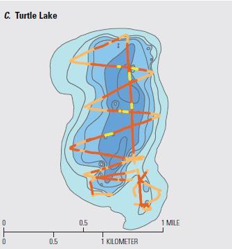
21 NE Metro Lakes Groundwater-flow (NMLG) Model Develop groundwater-flow model (tool) to assess - Groundwater and surface-water interactions in lakes - Effects of groundwater withdrawals and precipitation on lake levels Run nine steady-state MODFLOW model simulations Average - eight hypothetical scenarios ± 30% change in groundwater withdrawals ± 5% change in precipitation combination of precipitation/groundwater withdrawal changes
22 Groundwater-flow Model Design Based on Metro Model 3 (MM3) Using bedrock elevations, hydraulic conductivty zones, and some boundary conditions New configurations/packages - Finer model grid, more detailed - Quaternary layering, four versus one layer - Updated recharge - Lake Package: applied to 6 lakes - Refined RIV Package: rivers, other lakes, and streams

23 NEML Model Boundary East - MM3 boundary N North - DNR Level 8 watersheds West/South - DNR Level 8 watersheds or 5 km perpendicular to river Encompasses most of North/East Metro GWMA W E S

24 Lake Package Used in model for representing 6 lakes Simulates water balances for lakes Lake Criteria Max lake depth > 25 feet Surface Area > 75 acres More than 3 miles from model boundary Lake-level data in at least 50 percent of months during

25 Pumping Wells Modelled with Multi-node Well (MNW2) package High capacity wells from MDNR Source Water database 838 wells New wells added since MM3 was produced
26 Model Calibration Groundwater-flow Model Calibration Targets Sources - USGS, BCWD, RCWD, VCWD, MNDNR Groundwater levels 3,392 observation wells Streamflow (low flows) - 5 stream gages Lake Levels MNDNR 6 lakes (Lake Package) PEST Parameter ESTimation tool Calibration data was weighted based on quality Model parameters were estimated
27 Model results Overall, model calibrated well over the Northeast Twin Cities Metropolitan Area Groundwater withdrawals and precipitation can affect lake-water levels and budgets Effects of groundwater withdrawals on the lakewater levels varied with the number of wells and amount of withdrawals from wells near the lakes Lakes are providing water to underlying aquifers

28 Potentiometric Surfaces Groundwater-Flow Directions Glacial aquifer Prairie du Chien and parts of Glacial aquifer
29 Simulated Lake Water Budgets Average Percentages Inflow Outflow Lake Direct Surface-Water Ground Evapo Surface Ground Precip Runoff Water Trans. Water Water Big Marine Lake Elmo Snail White Bear

30 Water-level Changes, in feet Glacial aquifer 30% GW withdrawal increase 30% GW withdrawal decrease


31 Water-level Changes, in feet - Prairie du Chien aquifer 30% GW withdrawal increase 30% GW withdrawal decrease

32 Lake-water Levels for Different Groundwater Withdrawal Simulations
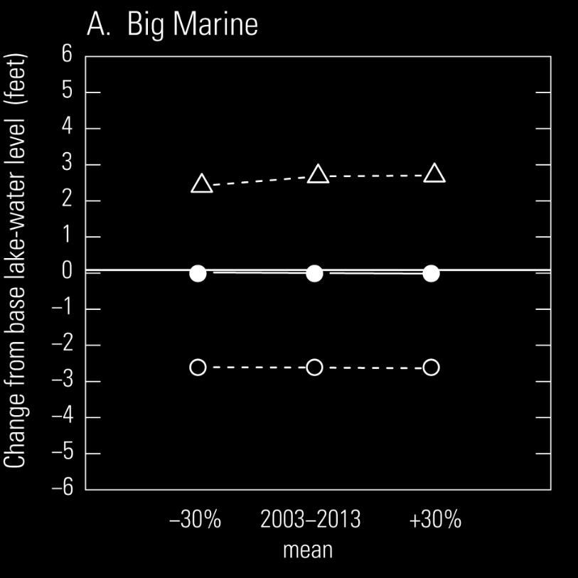
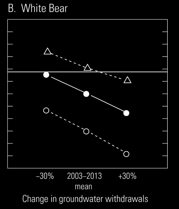
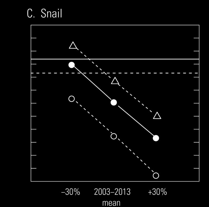
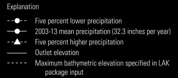
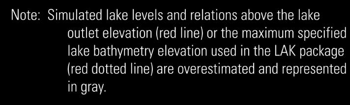
33 Lake-water-level Changes Groundwater Withdrawal and Precipitation Change Simulations
34 Potential other future work Characterization of glacial sediments and buried bedrock valleys below lakes i.e. White Bear Lake Groundwater-flow model develop transient simulations Common Lake Information data base

35 USGS Reports Available online /sir
36 Questions?