The key contact for this proposal is Belinda Bastow (AngloGold), Environmental Manager Exploration/ Tropicana:
|
|
|
- Nathan Atkinson
- 5 years ago
- Views:
Transcription


1 Tropicana Gold Project: Public Environmental Review 1. Introduction
2 1. INTRODUCTION This document and supporting appendices comprises the Public Environmental Review (PER) documentation for the Tropicana Gold Project (the Project). The Project is subject to State environmental assessment under the Environmental Protection Act 1986 (EP Act) and Federal assessment under the Environment Protection and Biodiversity Conservation Act 1999 (EPBC Act). The Federal assessment will make use of the Bilateral Agreement between the State and Federal Governments. This Chapter introduces the proponent and the Tropicana Gold Project, describes the purpose of this document and summarises the legislative and policy framework PROPONENT The proponent of the Project is the Tropicana Joint Venture (the Joint Venture). The Joint Venture is between AngloGold Ashanti Australia Limited (AngloGold; 70 % stakeholder and manager) and Independence Group NL (IG; 30 % stakeholder); the Joint Venture commenced in AngloGold is a wholly owned subsidiary of AngloGold Ashanti Limited, an international gold producer with projects located on four continents. AngloGold wholly owns and operates the Sunrise Dam Gold Mine and until June 2009 owned 33 % of the Boddington Gold Mine (Newmont 67 %; divestment made to Newmont). Until 2003, AngloGold also owned and operated the Union Reef Gold Mine in the Northern Territory until IG is an Australian Stock Exchange-listed, Perth-based nickel and gold exploration and mining company involved in several joint venture operations and is owner-operator of the Long Nickel Mine in Kambalda, WA. The key contact for this proposal is Belinda Bastow (AngloGold), Environmental Manager Exploration/ Tropicana: Physical Address: AngloGold Ashanti Australia Limited Level 13 St Martin s Tower Postal Address: AngloGold Ashanti Australia Limited PO Box Z St George s Terrace Perth WA 6831 Perth WA 6000 Telephone: Mobile: bbastow@anglogoldashanti.com.au Additional information can be found on the Joint Venture website ( EXPLORATION HISTORY The Joint Venture holds exploration and mining tenements that cover approximately 13,000 km² across a linear distance of 330 km on the western edge of the Great Victoria Desert (GVD) biogeographic region (Figure 1.1). The main aim of the Joint Venture was to investigate an untested gold-in-soil anomaly evident in historical data reported in the Department of Mines and Petroleum (DMP) (formerly the Department of Industry and Resources) open file reports. Early reconnaissance led to the interpretation that the area represented an enclave of Archaean age greenstone rocks within the mobile zone of the Proterozoic Albany-Frazer belt. The area was considered prospective for lode-gold style deposits analogous with those in the highly-endowed Yilgarn Craton of Western Australia. 1-1

3 Figure 1.1: Location of the Proposed Tropicana Gold Project in Relation to the Joint Venture s Exploration Tenements and Regional Features Broad spaced, first pass aircore drilling in late 2002 over the peak of the published soil anomaly returned several encouraging results at the Tropicana prospect. Further reverse circulation and diamond drilling indicated that higher grade mineralisation was present at Tropicana than first thought and led to a ramp up in exploration intensity in October By the end of 2005, significant mineralisation had been identified by broad spaced drilling over a strike length of one kilometre. Drilling in the first quarter of 2006 identified the Havana deposit, 1.5 km to the south of the Tropicana deposit. To date, drilling at the Tropicana and Havana deposits has defined a mineralised corridor ~ 1.2 km wide and spans an approximate 5 km strike length. Preliminary results from drilling outside the main Tropicana/Havana deposits suggests that the mineralised corridor extends further north and south. The Tropicana and Havana deposits are hosted in tectonically reworked Archaean metamorphic rocks that form the eastern margin of the Yilgarn Craton. The mineralisation style and the host rock types are distinctively different to typical Yilgarn greenstone-hosted gold deposits. These factors indicate that the Tropicana/Havana discovery represents a new deposit style in a previously unrecognised and unexplored gold province TROPICANA GOLD PROJECT The proposed Project is an open-cut gold mine with supporting infrastructure that is planned to develop the Tropicana and Havana deposits (and adjacent satellite deposits). The proposed mine is located approximately 330 km east northeast of Kalgoorlie and 200 km east of Laverton. The current published resource for the Project totals 75 Mt at 2.07 g/t Au for 5.01 Moz. At current gold prices and gold mining and processing costs not all of this 1-2
4 resource is economically viable. Exploration is continuing and it is envisaged that resources may expand over time and that changes in the gold price and cost structure could increase the economically extractable resource. To provide for the potential for resource expansions and negate the requirements for supplementary environmental impact assessments, this PER is based on open pit mining and mineral processing operation that has an annual through-put at up to 7 Mt per annum with an anticipated mine life of 15 years, which implies an economically viable resource greater than that defined to date. Despite the relative proximity to the mining hub of Kalgoorlie, the region surrounding the deposits is characterised by a lack of infrastructure, and a lack of gold-targeted exploration. Exploration for gold and other minerals occurs in the region. The Project will require substantial investment in supporting infrastructure, including an access road appropriate to the level and type of traffic, communications system, power supply, water supply, accommodation village and aerodrome. The region surrounding the Project lacked detailed environmental baseline data prior to the Joint Venture s activities in the area. As a result the Joint Venture has adopted a broad and holistic approach to baseline surveys. This has served two main purposes: to enable the Joint Venture to identify environmental constraints and subsequently minimise impacts; and, to ensure an appropriate level of knowledge is available to enable regulatory bodies and the wider community to assess the potential environmental impacts of the Project. This PER is for the establishment of a gold mining and processing facility and associated supporting infrastructure for the Project (Figure 1.2; refer to Map Attachment 1) including: Operational Area A proposed gold mine including the pit(s), waste landforms, stockpiles, tailings storage facility, processing plant, water storage dams, power station, internal roads, administration block(s), aerodrome, village and other supporting infrastructure; Infrastructure Corridor(s) Access road and communications corridor to link the Operational Area to existing communication and road networks in the Goldfields Region; and, Water Supply Area Two options have been considered, the Minigwal Trough and the Officer Basin Water Supply Areas. The Minigwal Trough has been confirmed as an appropriate source of water for the Project. 1-3
 of the proposed Project.")


5 Figure 1.2: Location of the Proposed Tropicana Gold Project with Regional Topographic Features 1.4. DOCUMENT PURPOSE AND STRUCTURE The purpose of the PER is to present an Environmental Impact Assessment (EIA) of the proposed Project. Following an eight week public review period, the Environmental Protection Authority assesses the proposal and provides recommendations to the Minister for the Environment for a final decision. A formalised and detailed risk assessment process for the proposed Project was initiated as the Joint Venture progressed from exploration into pre-feasibility phase, prior to commencing the formal environmental assessment process of which this PER document forms a part. The primary aim has been to identify potential environmental consequences to all activities and to assign appropriate responses to reduce environmental risks. This PER document outlines the potential environmental impacts related to the construction and operation of the Project as identified via a project-wide risk assessment process (Chapter 9), and details the relevant management measures to avoid, minimise or eliminate these impacts (Chapters 7, 8, 10 and 14). The purpose of this document is to: provide a detailed description of the Project; describe activities undertaken by the Joint Venture to engage and consult with stakeholders; describe the results of the Project-specific environmental risk assessment process; identify potential environmental impacts of the Project; explain the environmental management framework for the Project; and, present the results of environmental studies that have been completed for this environmental impact assessment (as appendices). 1-4
6 This PER is structured as follows: the main report including an executive summary (Comprising 14 Chapters and Appendix 1), which is intended to be independently understood without reference to supporting technical reports; Appendix Series 2 containing a series of supporting technical studies, the key elements of which are summarised in the main report as relevant; Appendix Series 3 detailing Environmental Management, containing the Project Environmental Management Systems and Management Strategies; and, Appendix 4 - the final Environmental Scoping Document (ESD) LEGISLATIVE AND POLICY FRAMEWORK In undertaking the PER, Project is cognisant that relevant environmental policies and guidelines need to be addressed. The relevant policies and guidelines for the assessment of environmental factors are listed in Table 1.1. Chapter 5 discusses these in further detail. Table 1.1: Policies, Legislations and Guidelines Relevant to the Tropicana Gold Project EPA Documents Environmental Protection Bulletin No.1 Environmental Offsets Biodiversity Guide to EIA Environmental Principles Factors and Objectives Position Statement 2: Protection of Native Vegetation in Western Australia Position Statement 3: General Requirements for Terrestrial Biological Surveys Position Statement 5: Environmental Protection and Ecological Sustainability of the Rangelands in Western Australia Position Statement 6: Towards Sustainability Position Statement 7: Principles of Environmental Protection Position Statement 9: Environmental Offsets Guidance Statement 6: Rehabilitation of Terrestrial Ecosystems Guidance Statement 12: Guidance Statement For Minimising Greenhouse Gas Emissions Guidance Statement 19: Guidance Statement for Environmental Offsets Guidance Statement 20: Sampling of Short Range Endemic Invertebrate Fauna for Environmental Impact Assessment in Western Australia Guidance Statement 41: Assessment of Aboriginal Heritage Guidance Statement 51: Terrestrial Flora and Vegetation Surveys for Environmental Impact Assessment in WA Guidance Statement 54a: Sampling Methods and Survey Considerations for Subterranean Fauna in WA (draft) Guidance Statement 54: Consideration of Subterranean Fauna in Groundwater and Caves during Environmental Impact Assessment in WA Guidance Statement 55: Implementing Best Practice in Proposals submitted to the EIA process Guidance Statement 56: Terrestrial Fauna Surveys for EIA in WA 1-5
7 Table 1.1: Policies, Legislations and Guidelines Relevant to the Tropicana Gold Project continued State Government Legislation Aboriginal Heritage Act 1972 Bio-security and Agriculture Management Act 2007 Bush Fires Act 1954 Conservation and Land Management Act 1984 Contaminated Sites Act 2003 Dangerous Goods Safety Act 2004 Environmental Protection Act 1986 Health Act 1911 Land Administration Act 1997 Local Government Act 1995 Mining Act 1978 Mine Safety and Inspection Act 1994 Native Title (State Provisions) Act 1999 Occupational Safety and Health Act 1984 Planning and Development Act 2005 Poisons Act 1964 Soil and Land Conservation Act 1945 Rights in Water and Irrigation Act 1914 Wildlife Conservation Act 1950 Federal Government Legislation, Strategies and Guidelines Aboriginal and Torres Strait Islander Heritage Protection Act 1984 Civil Aviation Act 1988 Environment Protection and Biodiversity Conservation Act 1999 Intergovernmental Agreement on the Environment 1992 National Greenhouse Strategy (Commonwealth of Australia 1998) National Strategy for Ecologically Sustainable Development 1992 National Conservation Strategy for Australia 1983 National Strategy for the Conservation of Australia s Biological Diversity 1996 Native Title Act 1993 Draft Policy Statement: Use of environmental offsets under the Environment Protection and Biodiversity Conservation Act 1999 International Agreements China-Australia Migratory Bird Agreement 1986 Japan-Australia Migratory Bird Agreement 1974 Republic of Korea-Australia Migratory Bird Agreement 2006 Other Standards Implementation Framework for Western Australia for the Australian and New Zealand Guidelines for Fresh and Marine Water Quality and Water Quality Monitoring and Reporting. HB 203:2006 Environmental Risk Management Principles and Procedures OHSAS18001 Safety Management System AS/NZS 4360:2004 Australian/ New Zealand Standard: Risk Management ISO Environmental Management System Western Australian Environmental Protection Act 1986 The EP Act is the primary piece of legislation that governs environmental impact assessment and protection in Western Australia. Approvals can be required under two parts of the EP Act: Part IV and Part V. Projects with the potential to significantly impact on the environment are assessed under Part IV, while prescribed premises (as listed under Schedule 1 of the Environmental Protection Regulations 1987) must be approved under Part V. The Project will require assessment and approval under both Part IV and Part V. 1-6
8 Environmental Impact Assessment under Part IV of the Environmental Protection Act Under Part IV of the EP Act at the time of the Project s assessment, the EPA can implement one of five levels of assessment for a proposal based on the potential for environmental impacts and the predicted interest from the public. The level of assessment for the Project was set at a Public Environmental Review (PER). Proponent requirements at the PER level of assessment are to: prepare and obtain approval from the EPA for an Environmental Scoping Document (ESD) to outline the proposed scope of work for environmental and social impact assessment studies, incorporating the advice of other decision making authorities; undertake the relevant studies and investigations; prepare a PER document which describes the project, the potential impacts and proposed management measures to eliminate, minimise or mitigate these impacts (this document); make the document available for a public review period (after the EPA is satisfied that it is adequate for public release); and, respond to issues raised in public submissions. The EPA assessment incorporates the PER document, the public submissions and the proponents responses to these submissions. A publicly available report including recommendations is provided by the EPA and can be appealed by any party within 14 days of publication. The Minister for the Environment makes the final decision on project approval and any conditions that are to be set on the project. The Ministerial conditions of approval are set in collaboration with other decision-making authorities. The Minister s decision and the conditions set can be appealed by the proponent and others within 14 days of release. Environmental Assessment under Part V of the Environmental Protection Act Under Part V of the EP Act, premises listed as prescribed under Schedule 1 of the Environmental Protection Regulations 1987 require a Department of Environment and Conservation (DEC) Works Approval for construction. The Works Approval is issued by the DEC after the environmental impact is completed by the EPA under Part IV of the EP Act, and after the Minister for the Environment has approved the proposal Federal Assessment under the EPBC Act The Federal EPBC Act is administered by the Federal Department of the Environment, Water, Heritage and the Arts (DEWHA). If the impacts of a project have the potential to significantly impact on a matter of national environmental significance, the project is to be referred to the Federal Government for a decision on whether the matter is a controlled action (therefore requiring assessment). The Project was referred to DEWHA on 9 June DEWHA confirmed that the Project does constitute a controlled action and that Federal assessment of the Project will occur via the Bilateral Agreement between Western Australia and the Federal Government (Figure 1.3). The Project was considered a controlled action, requiring assessment, due to the following controlling provisions: listed threatened species and communities (sections 18 and 18A); and, listed migratory species (sections 20 and 20A). 1-7

9 Under the Bilateral Agreement the assessment of the Project by the Federal Government at the level of PER was delegated to the Western Australian EPA. This process requires that the State provide the Federal Environment Minister with an assessment report on the Project. The Federal Environment Minister remains responsible for approving the project under the EPBC Act. Figure 1.3: Assessment Flow Diagram 1-8
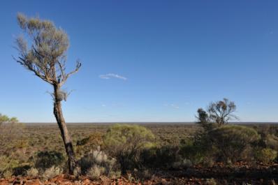
10 1.6. BIOLOGICAL KNOWLEDGE AND SURVEY SCOPING Recognising the absence of broad scale studies in the Great Victoria Desert, the Joint Venture committed to extensive surveys on a large scale to allow context to be put around the data being collected on the impacted areas. In undertaking the surveys, the philosophy of the Joint Venture was to acquire widespread regional knowledge to ensure that any impacts occurring within the Project footprint would not extend outside and have further regional impacts. To ensure that adequate biological information was available at critical stages of the Project (specifically at the conceptual design phase) and to enable data to be collected over a range of seasons, the surveys were commenced in August As a result the Joint Venture has completed vegetation mapping programs over 230,000 ha. In contrast, the predicted maximum disturbance area of Project is 3,440 ha. Additionally, the Joint Venture has (and continues to) participate in regional studies in conjunction with the Department of Environment and Conservation and local interest groups to assist in reducing the knowledge gap in the region. The Joint Venture s ongoing commitment to knowledge development for the region is demonstrated by the proposed biodiversity trust for the GVD bioregion, discussed further in the offsets section of the report in Chapter