CONSERVATION, OPEN SPACE, AND GROUNDWATER RECHARGE ELEMENT
|
|
|
- Harry Warner
- 5 years ago
- Views:
Transcription
1 Petition 175CPA-00PB CONSERVATION, OPEN SPACE, AND GROUNDWATER RECHARGE ELEMENT DATA & ANALYSIS REPORT EXECUTIVE SUMMARY The Conservation, Open Space, and Groundwater Recharge Element of the City of Gainesville Comprehensive Plan identifies the environmental resources of the city and describes the functions of those resources. The Element also identifies the key community priorities for environmental conservation, and proposes strategies for the attainment of such conservation. The following is a summary of the Element: THE VISION: A GREEN NETWORK A plan for environmental conservation and open space should include a grand vision which illustrates what the community expects Gainesville to look like in the future. This Element proposes a "Green Network" vision, which includes tree-lined creeks, tree-lined streets, and interconnected open spaces for recreation and wildlife habitat with the goal of connecting with the state network of wildlife corridors. Gainesville's plan for a citywide green network includes: The Network Maps. Identifies "gateway" streets, linear creek and open space corridors, rail-trails, and important natural resource areas. Restoring, Conserving and Preserving the Green Network. Several miles of city creeks and tree-lined streets offer visual beauty, wildlife habitat, and recreation for the community. Certain segments, however, have been damaged as a result of poor development practices in the past that are no longer permitted and also human activity. This section identifies some of the known segments in need of restoration and proposes preservation, conservation and restoration strategies. Regulating Environmentally Significant Open Space. This section describes how environmentally significant areas of the city are identified. It also describes strategies to protect environmentally significant land owned by the public and private sectors. Furthermore, the section discusses areas where there are environmental overlay zones (zones which apply special development regulations to properties containing
2 Page 2 environmentally significant attributes). In addition, the section describes environmental management of public parks and open space. Acquiring Land to Expand the Network. This section describes the ranking system used to identify properties that are most important for acquisition. The section also describes types of acquisition and acquisition issues. A Healthy Tree Canopy. A healthy tree canopy that supports urban wildlife, provides shade, stabilizes soil, and ameliorates the environment by moderating the effects of temperature extremes and stormwater run-off. GAINESVILLE'S NATURAL ENVIRONMENT: THE COMPONENTS There are five broad components of Gainesville's natural environment: Groundwater (includes wellfields, aquifer/groundwater recharge) Surface Waters Natural Communities (includes threatened and endangered species) Urban Forest/Tree Canopy Air Soils The Element describes the importance of each of the 6 components by discussing the functions of these natural resources. Functions are presented in such a way as to illustrate the benefits they provide. Current and potential problems associated with the abuse of these resources are also presented, as are the strategies available to protect natural resources. OTHER ISSUES The Element contains sections describing (1) "point source" pollution problems; (2) a proposal to establish a comprehensive and ongoing environmental monitoring program; (3) hazardous waste issues; and (4) economic costs of damage to the environment. INTRODUCTION
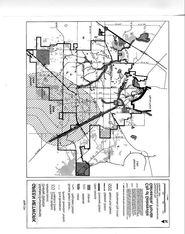
3 Page 3 Despite its urban character, the Gainesville area contains relatively high-quality air, soil, water, tree canopy and urban wildlife. Gainesville's natural environment provides essential services for the community. In addition to providing beauty, the natural environment stores, transports, and cleans surface waters and drinking water. It assimilates and filters pollutants. It offers recreational opportunities, and supports various economic activities such as tourism, mining, and agriculture. It provides habitat for plants and animals. Most importantly, Gainesville's natural environment is self-managing. That is, when allowed to function naturally, it provides services without the need for large public expenditures. Trees and wetlands, for example, filter pollutants much more cheaply than smokestack scrubbers or sewage treatment plants. The primary purpose of the Conservation, Open Space, and Groundwater Recharge Element is to identify Gainesville's natural environmental features, describe the functions and services they provide to the community, and describe the actions that should be taken to preserve, conserve, or restore the functions of the natural features found in the community. By protecting the natural environment, substantial protection is provided for Gainesville's long-term quality of life, and the cost of pollution and hazard control is minimized. Gainesville's Green Network THE VISION The Gainesville urban area contains several outstanding natural features. These features, such as Paynes Prairie, Newnans Lake, Bivens Arm, and Hogtown Prairie, are islands of spectacular environmental quality interspersed throughout the urban landscape. The Recreation Element Data Collection & Analysis Section refers to these islands as "gems" of an "Emerald Necklace." Tying the gems together are a series of connecting strands, or green corridors that connect the urban forest with the real forest. In the most densely populated areas, the corridors consist of tree-lined streets and gateway streets. These will connect to areas along creeks and trails, which will then connect with larger natural areas, such as Paynes Prairie, San Felasco Hammock, the Austin Carey Forest, Newnans Lake, or Gumroot Swamp, which in turn are connected to very large natural areas like the Ocala and Osceola National Forests. At a local level, then, our green corridors form the "Gainesville s Green Network," shown in the series of maps 2a, 2b and 2c. Protecting the network and restoring parts of it that have been degraded provide the following benefits: * A maximum amount of visual and physical public access to the natural environment at minimum cost.
4 Page 4 Trees and Creeks * Habitat corridors and islands for urban wildlife, so Gainesville continues to enjoy large and diverse populations of birds and small animals. * Preservation of representative samples of the ecological communities of Alachua County. * Conservation of the forest function of the urban forest. Trees and creeks are the most visible ingredients of the Green Network. Gainesville's trees and creeks are either directly or indirectly associated with almost all categories of environmental preservation, conservation, and restoration: * Creeks receive large volumes of untreated stormwater runoff. Such runoff is probably the most significant source of urban pollution. Creeks are therefore essential to the cleansing of runoff before it reaches our aquifer system. * Soil erosion and septic tank effluent may negatively affect creeks. Maintaining a buffer of trees and other vegetation along creeks helps to protect creek water quality. * Creekside lands contain the largest and most important acreages of complete plant communities including trees and other forms of vegetation, and habitat for wildlife. * A strong connection between conservation and passive recreation exists. Publicly accessible recreation along the greenways of the network provides environmental education and stimulates appreciation for the natural environment. * Several lakes and wetlands are physically connected to creeks. * Flow from creeks and lakes enters the Floridan Aquifer directly through sinkholes and wells. * Gainesville is known as a City in a Forest. The excellent quality of Gainesville s tree canopy is recognized nationally [1997 Florida Tree City of the Year; first Florida recipient (1998) of the International Society of Arboriculture Gold Leaf Award]. Our many street trees offer Gainesville residents and out-
5 Page 5 of-town visitors a view of the natural beauty of the area. Trees are an important part of our image as a place where residents value the environment. * Trees are important in reducing air pollution and ameliorating rising global temperatures through the sequestration of carbon. They curtail soil erosion and enhance stormwater management. Properly placed trees can abate noise pollution. Strategically planted, they help reduce energy consumption by providing shading and cooling due to transpiration. * Trees and understory vegetation support the populations of songbirds, raptors and waterfowl in the city. They serve the same function for small amphibians (frogs and toads), reptiles (lizards, including anoles and skinks) and beneficial snakes (which aid in rodent control), and small mammals. Restoration and Preservation of the Green Network The quality of the Green Network can be improved dramatically through various restoration projects. Several formerly natural creeks are now little more than drainage ditches. Since drainage ditches typically lack most of the features necessary to provide for environmental quality (such as habitat, pollution and flood control, and aesthetics), the City should investigate the feasibility of restoring certain ditches to their formerly natural condition. Restoration strategies would vary based on the opportunities and constraints of each, but would generally strive to promote the list of "Creek Protection and Restoration Objectives. Examples of restoration techniques would include (but are not limited to) replacement of invasive exotic species with vegetation more suited to restoration objectives, reconfiguring the ditch from a straight-line channel to a more curvilinear pattern, establishing appropriate vegetation in areas with insufficient vegetation, and reducing the intensity of certain ditch maintenance efforts that tend to conflict with restoration objectives. Map 1 indicates creek segments that may be in need of restoration acres are being restored in the Hogtown Creek basin. The City of Gainesville is currently involved in a project to revitalize Sweetwater Branch Creek, which drains into Paynes Prairie Preserve, part of the State of Florida Park System. The Sweetwater Branch surface water basin contains approximately 1,710 acres and is located in the southeast central portion of the City of Gainesville. The majority of
6 Page 6
7 Page 7 surface water runoff from the Sweetwater Branch watershed is discharged directly to the creek without receiving treatment. The City s strategy is to construct a stormwater treatment facility to assist in reducing the nutrient and sediment load in the creek. Trees and Tree-Lined Streets More than any other factor, Gainesville's visual image is shaped by its trees. With a 60 percent canopy coverage, Gainesville compares very favorably with the national standard recommended by the American Forestry Association of 40%. The relative benefit of the national standard of 40% canopy is as follows: Increasing the tree cover in cities to the recommended level would improve the quality of air, water, and soil. In a metropolitan area with a population of around 2 million, planting more trees would mean a savings of more than $2 billion a year in stormwater management costs. (Moll, G America s Urban Forests: Growing Concerns. American Forests 103:3.) In 1993, Gainesville received a grant through the USDA Forest Services Urban and Community Forestry Program to conduct an urban tree assessment. The University of Florida School of Forest Resources and Conservation provided the City Arborist with a database of 21,380 records generated from a partial survey of trees on the public right-of-way. Of these records, 6,049 were a comprehensive assessment of the condition of street trees 12 in diameter or greater in the older parts of Gainesville; 11,286 records identified vacant planting spaces; 4,045 records were generated as a random sample that would enable statistical inference about the urban forest in general. Study of the database reveal that although Gainesville has an apparently plentiful urban forest, it lacks diversity in tree age and structure. Furthermore, only about half of the available planting spaces for trees actually have trees. The majority of large trees in Gainesville are oaks and pines. Laurel Oak and Water Oak, two species notorious for their inability to seal off internal decay, represent 32% of the large trees. The majority of emergency work orders requiring City tree crews to clear roads of fallen branches or uprooted trees are in response to tree failure by these two species. Live Oak, which is much more durable, comprises 16% of the urban forest. Loblolly Pine and Slash Pine represented 19% in 1993, but between 1994 and 1996, 3,450 pines were lost from the public right-of-way when Gainesville became the epicenter of an infestation of Southern Pine Beetle.
8 Page 8 Gainesville s innovative program to remove the invasive exotic Tallow trees from public property was featured in an article in the Journal of Arboriculture 25(2) entitled Controlling invasive exotics: A tallow tree replacement program campaign in Florida. The program has resulted in the removal of more than 300 Tallow trees from City streets. It coordinated the efforts of school children (through our Arbor Day celebrations), volunteers from the local chapter of the Florida Native Plant Society, University of Florida students, and local newspapers to locate the trees, which were then removed by government tree surgeons. Gainesville was also the site of important research on identifying hazardous trees ( The predictability of tree decay based on visual assessment, Journal of Arboriculture 22(6)). This research was funded by the City of Gainesville in response to citizen disappointment resulting from the removal of many large laurel oaks identified in the 1993 Urban Tree Assessment as being in poor condition. Gainesville is the only city in the United States that has a Tree Appeals Board. Whenever a regulated tree is to be removed from public property, a sign is posted and nearby residents are informed of the proposed action. If anyone wants to protest the removal, an appeal is filed. A panel of three professionals with certification in the plant sciences hears the case and render a decision. The Tree-mendous Gainesville program was established in 1995 to plant 1000 trees/year on public properties street rights-of-way, parks, drainage retention basins, etc. This program assures Gainesville will meet its code requirements for replanting after trees are removed, whether the removals were a result of a construction project or a consequence of becoming structurally unsound and therefore a hazard to public safety. Besides addressing the quantity of trees in the urban forest, the Tree-mendous Gainesville program strengthens the quality of the urban forest. A diversity of species is planted each year. In 1998 and 1999, more than 75% of the plantings were White Ash, Pop Ash, Basswood, Bald Cypress, Florida Elm, Winged Elm, Southern Magnolia, Fringe Tree, Florida Maple, Red Maple, Live Oak, Bluff Oak, Bluejack Oak, Shumard Oak, Chickasaw Plum, Redbud, Tulip Poplar and Tupelo. Along many streets, trees are in a healthy condition. Other streets, however, require various forms of tree restoration. New streets should be designed with dedicated places for trees to the extent feasible. Development projects require planting trees both to shade parking areas so that their canopy coverage will be 50% within 20 years and to buffer streets. At a minimum, stormwater management areas must be planted with the equivalent of one tree for every 35 of basin perimeter; the trees may be planted more closely to achieve aesthetic effects.
9 Page 9
10 Page 10
11 Page 11
12 Page 12 URBAN FOREST PROTECTION AND RESTORATION OBJECTIVES * Maximizing street tree canopy coverage. * Ensuring that gateway streets convey the message that Gainesville is a Tree City. * Promoting use of tree species native to north Florida (or otherwise appropriate for Gainesville streets) and representative of the diversity of trees that can be grown in this environment. * Minimizing the conflict between trees, paved streets and sidewalks, and utility lines through innovative urban forest management techniques (the use of biobarrier cloth, engineered soil, growth regulators, etc.). * Promoting species diversity by striving to have no more than 20 percent of any one tree genus citywide. (According to the City s 1993 Urban Tree Assessment, the most common tree species in Gainesville are laurel oak, live oak, sweetgum, slash pine, loblolly pine, water oak, camphor, magnolia, sugarberry, and red maple. Rather than these species, the City encourages future plantings, when appropriate, to consist of less common species, especially native elms, ash, oaks, magnolias, and maples. Refer to the List of Approved Trees of Gainesville, available from the Gainesville Department of Community Development.) * Continue to follow the pruning standards articulated in the American National Standard for Tree Care Operations Tree, Shrub and Other Woody Plant Maintenance so that as trees grow, they are structurally strong. This will reduce future pruning by guiding the trees to a natural cathedral structure. It will diminish the need for hazardous tree removals by eliminating included bark and codominant branching while trees are young. * Continue the effort to remove all Chinese Tallow trees from public property. This invasive exotic poses a serious threat to the stability of natural ecosystems, particularly wetlands. * Continue participation in the Tree City USA program. Gainesville has been a Tree City for 17 years and has received Growth Awards since the inception of that program. In 1997 Gainesville was selected Florida Tree City of the Year by the Florida Urban Forestry Council.
13 Page 13 Creeks * Continue to post signs explaining the reasons why trees must be removed and informing them that the Tree Appeals Board can be convened when citizens wish to present counter-arguments that might result in the preservation of such trees. * Continue review of development proposals to assure they do not result in unnecessary tree removals, that trees to be preserved are adequately protected during construction, and that sufficient new trees are planted to maintain the citywide 60% tree canopy coverage. * Make sure that an inspector with horticultural training approves the installation of landscaping on sites with approved landscape plans. The approximate 56 miles of creeks within the city form another green network traversing the city. The creek networks are lined with a diverse array of vegetation, and form the most important wildlife habitat within the city. Because of their attractiveness, creek networks are identified as an important component in Gainesville's active and passive recreation plans. Open Space CREEK PROTECTION AND RESTORATION OBJECTIVES * Maximize creek water quality by protecting wetlands and headwaters of significant creeks, discouraging construction activities close to creek banks which will result in sedimentation, and encouraging citizens who live along creeks to avoid planting exotics and over-fertilization. * Maximize the wildlife habitat and vegetative stability of the creek network. * Minimize the need for creek maintenance. * Provide public access, through publicly owned creek segments, in ways that will minimize disturbance to natural ecological communities. In urban areas such as Gainesville, open space is generally patchy, isolated, and disconnected. A key planning objective, which promotes public access and environmental awareness, wildlife habitat, and overall environmental quality, is to connect these isolated spaces with corridors. A
14 Page 14 connected green network provides opportunities for a greater diversity of wildlife, as well as creates the impression that there is more space than really exists. There are several categories of open space in Gainesville -- many of which can be part of the corridor-promoting Green Network. Table 7 in the appendix has an inventory of existing public and private park sites. OPEN SPACE OBJECTIVES AND FUNCTIONS * Urban definition, promotion of compact development, and control of urban sprawl * Space for recreation, and linkages to recreation and nature sites * Promoting public health and safety by controlling hazards and nuisances * Improving aesthetics and the image of the community, promoting pleasant and quiet surroundings, and therefore increasing property values. * Promoting environmental conservation, particularly through provision of natural habitat to support native wildlife diversity, habitat corridors, and preservation of important environmental features. * Moderating extreme climate conditions by controlling wind, temperature, and water. * Reducing air and water pollution. The following sections describe identification, regulation, and acquisition of environmentally significant open space. Identification of Environmentally Significant Open Space Although much of the natural environment in the Gainesville urban area has been developed for urban uses, the city retains many environmentally significant features (in addition to areas that can be restored to a more natural condition). In the Gainesville area, environmentally significant features include: Creeks Noted elsewhere in this Element for possessing a wide range of essential ecological and recreational functions. The City's "Regulation of Development Near Creeks" Ordinance in Gainesville s Land Development Code, Article VIII, Environmental Management recognizes the high value the community assigns to the creeks.
15 Page 15 Lakes Wetlands Floodplain Possess a wide range of essential ecological and recreational functions. An important component of the ecology of the urban area. Floodplains are widely recognized for providing important species habitat and wildlife corridors, pollution mitigation, recreational and visual amenities, and storage of floodwaters. Threatened and Endangered Species Habitat Preservation of such species is critical to the maintenance of biological diversity. The ability of these species to survive is an indicator of the ecological health of an area. Diversity promotes ecosystem survival and preserves species that may be important to humans in the future. Semiconfined Aquifer Zone, Stream-to-Sink Basins, and MunicipalWellfield The semiconfined zone of the Floridan aquifer system, stream-to-sink basins, and the municipal wellfield area merit similar protection; namely, land uses in these areas must be regulated to prevent the spilling of hazardous materials or polluted stormwater that can contaminate important groundwater resources. Significant Uplands Because they are so attractive for urban development, upland ecological communities are becoming threatened and endangered in the same way various species have become. As with threatened and endangered species, preservation of significant uplands is critical to the maintenance of biological diversity, particularly because many species are only able to survive in upland ecosystems. Particular consideration will be given to preserving uplands associated with wetlands and to uplands that have not been cultivated during the past 100 years. Radon Unlike other significant environmental features, radon is a feature to be minimized. Radon areas are a threat to human health, and regulations will be needed to reduce human exposure to radon gas. Some of the highest radon levels in the southeastern U.S. have been recorded in the Gainesville area. In order to improve the city's ability to protect environmentally significant features, lands containing such features have been identified and mapped. The following lands are areas where environmental overlay zones have been needed (zones that apply special development regulations to properties with environmentally significant attributes):
16 Page 16 Creeks: Lakes: Wetlands: Floodplain: Land within 150 feet of the break in slope at the top of the creek bank regulated by the "Regulation of Development Near Creeks ordinance" Land within 150 feet of the recognized shoreline of lakes adversely impacted by human-built structures or modifications Land within 35 feet of Flood channel lands, and to a lesser extent, floodplain lands. Significant Uplands: Land showing a level of biological rarity, diversity, or ecosystem importance which is significant on at least a county-wide basis, as identified by the Alachua County Conservation Element (adopted July 11, 1989). And as may be expanded by the City s 2000 Vacant Lands/Natural areas. Creeks, lakes, and wetlands have been chosen to identify environmental significance because: (1) they can be well defined on maps; and (2) they embody almost all of the significant environmental features of the city. (It should be noted that much of the city's groundwater recharge areas, floodplains, radon areas, and threatened and endangered species habitat areas are associated with creeks, lakes, and wetlands.) For significant features not associated with creeks, lakes, wetlands, floodplains, or significant uplands, specific regulations tailored to each feature should be adopted. Regulation of Environmentally Significant Open Space Lands within the environmental conservation areas receive special consideration by the City. The lands have been evaluated to determine whether some form of public acquisition is appropriate. If not appropriate, land development is governed by a special set of environmental regulations. Prescriptive regulations are the more traditional approach to land regulation. The developer is given no flexibility as to how to comply with the regulation. An example of such a regulation is: "there shall be no development within 200 feet of Lake Sunshine." Similarly, land use prohibitions will state which land uses are not permitted at particular locations. Performance-based regulations, on the other hand, describe what level of environmental protection is sought, and require that development projects be designed to attain that level of protection. They therefore give the developer increased flexibility in designing a site to attain environmental conservation objectives. In addition, they are much more sensitive to the natural features of individual sites. Performance controls ask the developer and site planner: "what are
17 Page 17 the environmental constraints at the site, and how can/should you design the site to conserve such natural features?" An example of such a regulation is: "there shall be no net loss of wetland acreage or functions." ENVIRONMENTAL CONSERVATION AREA OBJECTIVES * Protecting or restoring surface water quality * Protecting or restoring the wildlife habitat capability of urban ecological communities * Protecting or restoring vegetation * Protecting and enhancing Gainesville s tree canopy by replanting when and where trees are removed, fostering diversity of tree species, encouraging tree preservation and protection as construction activities are planned. * Protecting the Floridan Aquifer System * Minimizing exposure to radon gas * Minimizing flood damage * Protecting or providing scenic and passive recreational opportunities * Minimizing soil erosion * Removing invasive exotic plants and animals Environmental Management of Public Parks & Open Space Citizens of Gainesville and Alachua County have expressed great concern over development proposals in close proximity to environmentally significant areas. Citizen groups like the Women for Wise Growth, local chapters of the Audubon Society and the Sierra Club, Paynes Prairie Chapter of the Florida Native Plant Society often participate in the public comment portion of City Commission, Plan Board, and Development Review Board meetings. Many controversies exemplify the vulnerability of public parks and privately owned open spaces to the potentially harmful effects of human activity and development.
18 Page 18 There are two general types of parks and recreational open spaces: (1) "active" parks and open space, which are generally designed for relatively intensive recreational activities such as tennis or baseball; and (2) "passive" parks and open space, which rely on the natural amenities of the site for their attractiveness and value. As a result, there are differences in how the two types of sites should be conserved. For example, neighborhoods near active recreational sites may need to be protected from excessive noise and lighting. In addition, because persons using active sites are usually engaged in more intensive recreational activity, they are generally more tolerant of distractions from nearby land uses. (Nevertheless, many active park users will desire some level of site protection from nearby land uses.) On the other hand, passive sites may contain sensitive wildlife that must be protected from human disturbance from nearby land uses. Also, persons using passive sites typically expect a more peaceful and undisturbed environment. In summary, while both active and passive sites require some degree of protection from nearby land uses, passive sites will generally require a greater degree of protection than active sites. Conservation of both active and passive parks and open spaces can be accomplished by adopting some or all of the following strategies: * Adopting criteria and conditions that must be adhered to in instances where consideration is being given to selling public properties or converting such properties to a new use. Establishing buffers, when appropriate, to protect public parks and open spaces from nearby development. Land uses within buffer zones should be subject to performance standards that conform to the conservation objectives of public parks and open spaces. These objectives include: * Continue preparing an environmental inventory and management plan for existing and future public parks and open spaces, including an investigation of existing nuisance problems, environmental problems, and opportunities at these public sites. * Protecting or restoring viable populations of important plants and animals currently or historically found at the site from on- or off-site factors which threaten the viability of such features. Examples of threats include pesticides, vegetative clearing, noise, household pets, roads and vehicles, and soil erosion.
19 Page 19 * Protecting the site from on or off-site factors that would adversely impact onsite wetlands. * Protecting the site from on or off-site factors which would significantly modify the hydroperiod of the site wetlands, or degrade the quality of groundwater or surface waters at the site. A group of citizens have organized a Political Action Committee Legacy Lands and have succeeded in having a bond referendum, Alachua County Forever placed on the ballot for the November 2000 election. Acquisition of Environmentally Significant Open Space The Gainesville urban area contains large expanses of State-owned, publicly protected open spaces. Continued encroachment by human activities, however, may reduce the long-term viability of these natural open space systems. Many of these natural areas (which are all outside of city limits) are linked by the green network, which includes the Gainesville creek system, various trails, and tree-lined streets. While Gainesville s goal is for all streets to have trees, in 1993 the Urban Tree Assessment revealed that only ½ the spaces available for trees are actually filled. Some spaces are unsuitable for tree planting because of underground water, sanitary sewer or storm sewer pipes or urban design consideration. Priority is given to tree planting along corridors that connect significant open spaces. Other State-owned areas can be linked to the green network through various acquisition and regulatory strategies. Implementing Gainesville's green network plan will require efforts to acquire additional areas to strengthen and expand the network. Possible acquisition strategies include fee simple purchase of land, purchase of development rights (such as conservation, trail or scenic easements), acceptance of land or development rights, or provision for private common areas as sites are developed. The inclusion of an option for clustering in subdivision development was intended to preserve natural areas. To achieve this goal, the stormwater basins should be removed from qualification as a natural area to be preserved. During the past decade, the City of Gainesville applied for several grants through the Florida Communities Trust (FCT) Florida Forever (formerly Preservation 2000) Program. A major grant was awarded in 1991 to fund the acquisition of lands for a proposed Hogtown Creek Greenway, a 6-mile, 1,786 acre multi-objective study corridor. The primary purpose of the Hogtown Creek Greenway is to protect, restore and preserve the remaining ecologically sensitive and important features within the Project Site, and secondarily, to provide structured
20 Page 20 and controlled access to these lands through a comprehensive network of trails and other public facilities. The matching funds for this grant were obtained from the City s greenspace allocation of $150,000/year. This funding was dedicated and bonded for 10 years. In 2001, this obligation will be completed. The City Commission may again consider allocation of a dedicated funding source for acquisition of parks and natural areas. These funds could be used as a match for acquisition grants aimed at properties not selected by the County Commission authorizing the disbursement of Alachua County Forever funds, if the bond referendum passes on November 7, Most fee simple open space acquisition by the City is for the purpose of providing public parks. The Recreation Element Data Collection & Analysis Section calls for the acquisition of public conservation areas, community parks, neighborhood parks, and sports-complex parks. When parks are acquired, the City should survey the site for environmentally significant habitats, and establish a management plan for such areas. Over the past 10 years, Gainesville's park acquisition program has added mostly passive park acreage to the existing stock of parks within the urban area. Because most of the recent acquisitions have not been developed for recreation, it is possible that the pace of future acquisitions may be slowed in order to provide funding for park development. However, continued population growth and development, along with the possibility of new funding sources for parks, may result in efforts to maintain or increase the pace of park acquisitions. The Gainesville park and open space acquisition program uses a number of criteria to determine the value of properties being considered for acquisition. These criteria are designed to further the objectives of both the Recreation Element and the Conservation, Open Space, and Groundwater Recharge Element. Whenever possible, public schools should provide an area within their open space acreage for native natural habitat. Recreation/Open Space impact fees should also be considered as a means of funding further acquisition of public lands.
21 Page 21 GAINESVILLE'S NATURAL ENVIRONMENT: THE COMPONENTS There are six broad components of Gainesville's natural environment: GROUNDWATER Physical Geography * Groundwater (includes wellfield, aquifer recharge) * Surface Waters * Natural Areas (including threatened and endangered species) * Air * Soils * Urban Forest Gainesville is located in an area of karst topography. This topography is associated with the presence of a fracture system in the limestone underlying Alachua County. Karstic activity and stream bank erosion are the primary forces currently modifying the topography of the urban area. Four major physiographic regions are present in the Gainesville urban area: the Northern Highlands Plateau, the Northern Highlands Marginal Zone, the Western Valley and the Alachua Lake Cross Valley. The Northern Highlands Plateau is a relatively high flat area of low relief. From the surface down, it contains a layer of undifferentiated and unconsolidated Pleistocene to Holocene age sands and clayey sands, the Miocene Hawthorn Formation, a series of Eocene carbonate units (i.e., Ocala, Avon Park, Lake City and Oldsmar limestones) and the Paleocene Cedar Keys Formation. The Hawthorn Formation found in the Plateau is largely absent in the western and southern parts of the county due to erosion. Characteristic features of the Plateau include cypress hammocks, pine flatwoods and poorly drained swampy areas (e.g., Buck Bay, at the northern edge of the City).
22 Page 22 There are substantial variations in the thickness of the Hawthorn Formation in the Marginal Zone because streams in it have cut and continue to cut headward into the Northern Highlands Plateau. Abandoned as well as active stream valleys (e.g., Hogtown Creek valley) are present. Solution of the underlying limestone has produced numerous sinkholes and sinkhole ponds perforating the Hawthorn. Streams in the zone flow into sinkholes either before or just after they enter the limestone plain to the west or south (e.g., Hogtown Creek drains into Haile Sink). Karst features are particularly well developed along a linear cross-county fracture zone that runs in a northwest to southeast direction through the marginal zone. Both the Hawthorn and underlying limestone are extensively fractured in this zone. Inventory of Groundwater Gainesville relies exclusively on groundwater for its water supply. There are three groundwater zones underlying all or part of the Gainesville urban area. The aquifers within these zones are associated with the geologic formations discussed above. The zones include: (1) the surficial zone, (2) the intermediate zone, and (3) the Floridan zone. Map 4 provides an overview of the aquifer systems present. It is important to stress that the above zones and systems extend beyond the boundaries of the urban area. It also should be noted that water may flow between aquifer systems. A downward hydraulic gradient exists in Alachua County where multiple aquifer systems are present. The amount of water able to move from higher into lower aquifers, however, is limited by the thickness and permeability of the confining beds between the aquifers. Surficial Zone The surficial groundwater zone consists of a sequence of undifferentiated, relatively porous sands and clayey sands that are typically 10 to 30 feet thick in the Gainesville urban area. There is a surficial aquifer system within this zone in places where an underlying confining unit is present. In the urban area, the underlying confining unit is either the original Hawthorn Formation or a thick layer of reworked Hawthorn or other relatively impermeable sediments. The surficial aquifer operates under mainly unconfined, water table conditions. The surficial aquifer system is recharged primarily by percolating rainwater. Land use patterns, vegetation, topography and the permeability of local soils affect recharge efficiency. Water is stored for comparatively short periods of time, and flows within the system typically follow the topography of the land surface. Water is discharged through evapotranspiration; seepage to lakes, streams and wetlands; leakage to underlying aquifers where a downward hydraulic gradient is present; or pumpage from wells. In the Gainesville urban area, water withdrawn from wells in the surficial system is used for domestic and landscape irrigation purposes.
23 Page 23 Intermediate Zone The Hawthorn Formation is the intermediate groundwater zone. It consists of widely varying mixtures of clay, quartz sand, carbonate and phosphate. Single component beds (e.g., pure clay) are uncommon. The most common lithologies found are dolomitic, clayey sands and/or sandy dolomites. The intermediate aquifer system is found in highly variable, noncontinuous dolomitic, limestone and sandy layers within the Hawthorn Formation. Water-bearing lenses 20 to 40 feet thick were found at two sites in the Gainesville urban area in connection with groundwater contamination remediation studies (i.e., the Fairbanks Department of Transportation sandpit disposal site and the Cabot Carbon/Koppers Superfund site). These findings, however, do not constitute a comprehensive description of the intermediate aquifer system in the urban area. The intermediate aquifer system contains water under confined conditions. It is recharged by leakage from the surficial aquifer where a downward hydraulic gradient is present. Also, where the surficial aquifer is absent, it may be recharged directly by downward leakage of rainwater. Water is discharged from the system by vertical leakage through confining units, lateral leakage (e.g., along the erosional escarpment in the Northern Highlands Marginal Zone), or pumpage from wells. It is difficult to predict the location and extent of downward leakage into the Floridan because the sequence of sediments in the Hawthorn is so complex and variable, and the data available to make such determinations is limited. Water withdrawn from the intermediate aquifer system in the urban area is used for domestic and landscape irrigation purposes. Floridan Zone The Floridan aquifer system located in the Floridan zone is a prolific regional water-yielding unit which serves as the Gainesville urban area's primary source of water for drinking and other uses such as industrial processing and power generation. The Floridan is approximately 1500 feet thick in the urban area and composed of a sequence of hydraulically connected formations composed of limestone and dolomite. From top to bottom, these formations include: the Ocala Group, the Avon Park Limestone, the Lake City Limestone and the Oldsmar Limestone. 1 1 Estimated maximum thicknesses for these formations in Alachua County are 250 feet for the Ocala Group, 700 feet for the combined Avon Park and Lake City limestones and 530 feet for the Oldsmar Limestone. Solution features such as caverns are more prevalent in the Ocala Group than in other parts of the Floridan. This is because: (1) a significant amount of solution activity occurred in the unit before it was covered by deposits from later geologic ages; (2) the unit is closer to surface sources of carbon dioxide which induces additional solution; and (3) faster water movements through the unit promote the expansion and development of solution features. Also, the Ocala Group and Hawthorn, where present, dip gently to the northeast in the county.
24 Page 24 The Floridan aquifer is over 100 feet below the surface in the northeastern part of the urban area where the Hawthorn Formation is continuous and operates a protective confining unit. 2 In the northwestern, central and southern parts of the urban area, the Hawthorn is variable in thickness and perforated by sinkholes, leaving the Floridan semiconfined. In the southwestern corner of the urban area, the Floridan is as little as 20 feet below the surface and unconfined because the Hawthorn is absent. It is particularly vulnerable to contamination in this area because of the lack of an overlying confining layer. Map 3 shows the generalized boundaries of the confined, semiconfined and unconfined zones in the urban area. 3 According to well drilling records, the Floridan consists of three distinct zones and is not uniformly permeable from top to bottom at the Kanapaha Wastewater Treatment Plant, Murphree municipal wellfield and Lake Alice. Additional research is needed to determine whether the three-zone pattern exists throughout the urban area and the extent to which zone configurations vary from site to site. 2 It should be noted, however, that the Hawthorn Formation is not a completely impenetrable barrier even where it is continuous. It is more or less leaky depending on its components, thickness and structural integrity at a particular site. 3 Map 5 was derived from a county-wide "degree of confinement map" prepared by the Florida Geological Survey (FGS). The degree of confinement in each of the map's three designated zones depends on the amount of clays and clayey sands present and whether the layer of clays and clayey sands is perforated by sinkholes. The clays and clayey sands may or may not be a part of the original Hawthorn Formation. As a consequence, the zone lines on the FGS's map do not exactly match physiographic region boundaries. Those boundaries are closely associated with the presence or absence of the Hawthorn.
25 Page 25

26 Page 26
27 Page 27 Major Natural Groundwater Recharge Areas It is important to identify and manage groundwater recharge areas to ensure the future availability of groundwater and protect water quality. In the Gainesville area, "major natural groundwater recharge areas" (which are surrogates for the prime recharge areas contemplated by the Florida Statutes). The water management districts have not designated prime areas, but areas of high groundwater recharge that are for regional planning rather than site specific purposes have been mapped by the St. Johns River and the Suwannee River Water Management Districts. City staff has prepared subsets of these maps for Gainesville. Map 4 is the resultant map depicting high groundwater recharge areas in Gainesville. Stream-to-sink basins are an integral part of the karstic topography and natural drainage pattern of the region. Very little water leaves the urban area as surface water flow. 4 Instead, creeks, lakes and prairies drain into sinkholes and wells directly connected to the Floridan aquifer system. Creek and lake inflows include, among others, rainwater, urban stormwater and agricultural runoff, treated wastewater, power plant effluent, and air conditioner cooling water. Development has altered the quantity and quality of surface water flows, but the natural drainage system centered on stream-to-sink basins remains largely intact. There are 6 stream-to-sink basins in the urban area. 5 Sweetwater Branch and Tumblin Creek (via several lakes and Paynes Prairie) drain into Alachua Sink, which discharges into the Ocala Group limestone and possibly into limestone zones in the Hawthorn Formation. Water from Lake Alice flows into drainage wells, which discharge into solution cavities in the Ocala Group and Avon Park Limestone. 6 Turkey and Blues Creeks enter the aquifer in San Felasco 4 Prairie Creek, which drains Newnans Lake, does flow out of the urban area and into Orange Lake. However, this creek would flow into Paynes Prairie and drain into Alachua Sink if the canal and control structures diverting it were removed. Some of the creek's flow has been rerouted to the prairie. According to a 1988 report, though, the amount of inflow rarely exceeds 15 percent of the creek's total volume and, in dry years, it is often insignificant due to the presence of a weir on the creek below Newnans Lake. 5 It is possible to draw a hydrologic connection between waters in the Little Hatchet and Lake Forest creek basins and Alachua Sink since they all are related to Newnans Lake. Lake Forest Creek drains directly into the lake while Little Hatchet Creek drains into Gum Root Swamp which then discharges into the lake. Newnans Lake, as noted in footnote 6, drains into Prairie Creek, which provides some of the water entering Paynes Prairie and Alachua Sink. 6 Before 1948, the area where Lake Alice is located was a low marshy area that drained during wet periods into a sinkhole near what is now the eastern end of the lake. Lake Alice was formed after dams were built to prevent outflow from the area and effluent from the University of Florida's Wastewater Treatment Plant and cooling water were added. The Lake Alice basin is treated as a natural stream-to-sink recharge area because lake overflows would drain into a sinkhole if they were not diverted into drainage wells. Also, the lake is very similar to Sweetwater Branch in terms of its inflows and it is hydrologically connected to Bivens Arm, Sweetwater Branch and Alachua Sink during some high water stages.
28 Page 28 Hammock Preserve. Hogtown Creek drains into Haile Sink, which discharges into the lower part of the Ocala Group. The total drainage area of Alachua Sink, Lake Alice and Haile Sink is about 48 square miles. A United States Geological Survey (USGS) study conducted in the early 1980s estimated total recharge from the three sources was averaging 33 million gallons a day, including 7 million gallons of treated wastewater. It concluded these sources could account for 75 percent of the recharge occurring in the Gainesville area, assuming a recharge rate of 15 inches a year.

29 Page 29
30 Page 30 The semiconfined zone is extensive in the urban area. In addition to recharge through numerous sinkholes, some recharge may occur in this zone as a result of downward leakage through the Hawthorn Formation. The Floridan is not unconfined anywhere within the Gainesville city limits, according to the latest Florida Geological Survey (FGS) confinement map available. As indicated above, however, the southwestern corner of the urban area lies within the unconfined zone. This zone is a major recharge area because: (1) rain is able to percolate directly into the Floridan through sandy soils; (2) the aquifer is a sufficient distance below the surface to create a downward hydraulic gradient and limit evapotranspiration; and (3) the Floridan in this area has the ability to accept water and move it away quickly. An FGS study estimated the unconfined zone in southwestern Alachua County has an average recharge rate of at least 10 inches a year. That rate is equivalent to almost one-half million gallons a day of recharge per square mile. According to a 1988 USGS map of predevelopment recharge and discharge statewide, most of the Gainesville urban area (roughly the semiconfined and unconfined zones) has provided recharge of over 10 inches a year. The rest of the urban area (roughly the confined zone) is included in a zone that has provided 1 to 10 inches of recharge a year. To date, the St. Johns River (SJRWMD) and Suwannee River (SRWMD) water management districts have not identified or mapped "prime" recharge areas in Alachua County pursuant to the requirements of Sec , FS. Artificial Recharge The Kanapaha Wastewater Treatment Plant is a tertiary treatment facility under permit by the Florida Department of Environmental Protection (DEP) which uses aquifer recharge wells to dispose of treated wastewater. The amount of recharge involved is substantial (i.e., average flow was 7.6 million gallons a day in 1999). This may increase up to the permitted maximum injection rate of 10 million gallons per day. The injection wells discharge to a deep zone of the Floridan, which extends from the lower part of the Avon Park Limestone into the Oldsmar Limestone (450 to 1020 feet below the surface at the plant site). The quantities of water injected have reversed the usual downward hydraulic gradient in the area surrounding the wells, and some upward "mounding" of water around wells has been observed. The potentiometric effects of injection have been nearly negligible at a regional scale, however, because the receiving zone is fractured and capable of transmitting large quantities of water away from the plant site. Increasing the amount of recharge will expand the localized area affected by the gradient reversal and raise the potentiometric head of the Floridan around the plant to some degree.
31 Page 31 The University of Florida recently upgraded its wastewater treatment plant from a secondary into a tertiary treatment plant which produces effluent meeting drinking water quality standards. The plant primarily uses aquifer recharge wells for effluent disposal. Reclaimed water is added to Lake Alice as needed to maintain lake water levels. FDEP and the SJRWMD and SRWMD (within their district boundaries) evaluate and permit artificial injection facilities. See Chap , 40B-5 and 40C-5, FAC. Both the Kanapaha and University of Florida plants lie within the SJRWMD. State requirements relating to underground injection control are based on standards set in the federal Safe Drinking Water Act. The stated purpose of DEP s rules in Chap is to protect the quality of the state's underground sources of drinking water and to prevent further degradation of the quality of other aquifers adjacent to the injection zone that may be used for other purposes. Movement of Groundwater in Floridan Aquifer System The Floridan aquifer system is a vast reservoir of water which flows on a regional basis from areas of recharge to areas of discharge (e.g., along rivers and coasts). The potentiometric surface of the Floridan and topography tend to be high in recharge areas and low in discharge areas. Flow of the Floridan in Alachua County appears to be controlled primarily by the presence of an area of high potentiometric surface in the karstic highlands region in western Putnam and Clay counties and the presence of an area of low potentiometric surface along the Santa Fe River. The roughly oval highlands region is identified as an area of high recharge in the SJRWMD's 1990 Lower St. Johns/St. Marys Ground Water Basin Resource Availability Inventory. 7 Billions of gallons of recharge are attributed to this area annually and it is believed a portion moves in a westerly direction and eventually replenishes Gainesville's municipal wellfield. Also, some recharge occurs in eastern Alachua County as a result of leakage through the Hawthorn Formation. The travel time form the Lake Santa Fe region to the Murphree well field is estimated at approximately 1000 years. Groundwater leaving the urban area moves in a northwesterly direction and ultimately discharges into the Santa Fe River primarily through springs. In the Gainesville urban area, the pattern of groundwater flow in the Floridan has changed dramatically in recent years. This change followed the 1975 relocation of the municipal wellfield 7 There are differences in opinion about whether the karstic highlands region is in fact a discrete high recharge area. A 1988 USGS map not cited in the 1990 SJRWMD groundwater basin inventory, for example, shows part of the region as a comparatively low recharge area (e.g., less than 1 inch a year). These differences may be resolved as the SJRWMD proceeds with its program for delineating recharge areas within its district. A recharge area(s) other than or in addition to the karstic highlands may be a primary source of water replenishing the city's wellfield.
32 Page 32 from Main Street in south Gainesville to northeast Gainesville. The predominant direction of groundwater flow under the city now appears to be toward the northeast and the wellfield's expanding cone of depression. There are currently at least five major features capable of influencing the direction of groundwater movement in the urban area. As indicated above, the municipal wellfield is a major influence since pumping pulls additional groundwater toward the point of withdrawal and increases the rate of flow, and the amount of water being withdrawn is substantial. The other four influences include Alachua Sink, Haile Sink, and the University of Florida and Kanapaha Water Reclamation Facility (KWRF) recharge wells. Water tends to move away from these influences because they are points of recharge. It should be noted that, while the direction of regional flows can be estimated for a karst aquifer, precise flows are extremely difficult to trace because of a karst aquifer's complex three-dimensional pattern of fractures, fissures and solution channels Also, it is important to note that flow rates tend to be highly variable in a karst aquifer. Groundwater typically moves slowly in porous rock (e.g., a few feet a day) but rapidly where solution features allowing conduit flow are present (e.g., hundreds of feet a day). Supply and Conservation of Groundwater Floridan groundwater resources tend to be plentiful in the Gainesville urban area. This is because, as indicated above, the urban area receives substantial amounts of recharge from adjacent largely undeveloped counties and it lies within a county that functions as a recharge area. Notably, the USGS in a 1988 study included Alachua County in an area designated as potentially "highly favorable" for large groundwater development. It also concluded pumpage from the Floridan has been and continues to be supplied primarily by the diversion of natural discharge and by induced recharge rather than by loss of water from aquifer storage. Another important consideration is that the urban area's water supply is not threatened by lateral saltwater intrusion due to Alachua County's inland location. The SJRWMD and SRWMD regulate the use of groundwater in the county through their issuance of consumptive or water use permits. See Chap. 40B-2 and 40C-2, FAC, which implement Part II of Chap. 373, FS (Florida Water Resources Act of 1972). The supply issue, however, is complicated by a number of factors. First, although the Floridan aquifer system has the capacity to hold and transmit vast amounts of water, full utilization of that capacity depends on the availability of adequate amounts of rainfall. Extended rainfall deficits in recharge areas lead to declines in groundwater levels which, in turn, can leave shallower wells dry, create conflicts among water users with competing demands, cause harm to natural systems, lower water pressures in wellfields, and promote the formation of sinkholes.
33 Page 33 The water management districts have the authority to declare water shortages and implement conservation measures when they determine insufficient water is available to meet the present and anticipated needs or when conditions dictate a temporary reduction in total use to protect water resources from serious harm. Emergencies may be declared under extraordinary circumstances. See Sec & , FS. Both the SJRWMD and SRWMD water management districts have adopted water shortage plans. Under both plans, the districts seek assistance in enforcing declared water shortages from local government and law enforcement officials. On the local level, GRU promotes water conservation by providing ongoing public education programs, maintaining its water distribution system properly to minimize water losses, and recycling water at its two power plants. Water conservation is also promoted through the city's ongoing water loss reduction program and allowance of graywater recycling systems (Sec of city code). In addition, it is fostered through implementation of the landscaping requirements in the city's zoning code which operate to protect the tree canopy, retard stormwater runoff, and encourage aquifer recharge and use of native vegetation (Chap. 29, Articles IV and XV). The City maintains a list of recommended landscape trees that includes many drought-resistant native species useful in conserving water. Gainesville Regional Utilities has a water reuse program, which includes distribution of reclaimed water from the Kanapaha Water Reclamation Facility for use as irrigation and in aesthetic water recharge features. Irrigation uses include the Haile Plantation Golf Course, Kanapaha Park, Kanapaha Middle School and Kanapaha Botanical Gardens and irrigation of lawn and landscape areas in the southwest area. Aesthetic water features include features located at Kanapaha Botanical Gardens, Chapman Trails Park, Kanapaha Middle School and others. Another consideration is that much of the water withdrawn from the Floridan for use in the urban area is reused indirectly because it is returned to its source through the wastewater disposal methods utilized by GRU and the University of Florida. In 1999, for example, 9.2 billion gallons of water were withdrawn from the Murphree wellfield and approximately 4.7 billion gallons of treated wastewater were returned to the Floridan via the Kanapaha plant's aquifer recharge wells and Sweetwater Branch/Paynes Prairie/Alachua Sink. The wastewater total does not include effluent from the University of Florida Wastewater Treatment plant, which enters the Floridan via aquifer recharge wells. An additional factor complicating the groundwater supply issue is wellfield management. Careful management is needed to avoid adverse impacts on groundwater resources even where the supply is plentiful. In 1989, GRU installed a Supervisory Control and Data Acquisition (SCADA) System at the Murphree wellfield to enhance its ability to monitor and manage well
34 Page 34 performance and regulate the wellfield's cone of depression. At that time, well drawdowns varied from 15 to 50 feet due to the fracture system within the Floridan. The need for the SCADA system became apparent in June 1989 when extensive pumping of wells in a set combination reduced artesian pressure in the Floridan almost to the bottom of the Hawthorn Formation due to interference among the wells. GRU considered this an unacceptable practice because it could have encouraged migration of water from the intermediate aquifer system into the Floridan. Contamination is present in the intermediate system at the Fairbanks DOT sandpit disposal site and possibly at the Cabot Carbon/Koppers Superfund site, both of which are approximately two miles from the wellfield. In 1990, GRU initiated construction of three additional production wells to increase wellfield capacity and provide redundancy. It also proceeded with its development of a wellfield operational management program designed to minimize further decline in artesian pressure in the Floridan and provide adequate well spacing. During the year 2000, significant well drawdowns occurred due to low aquifer levels due to a prolonged period of drought, combined with extremely high demands resulting from high irrigation demands. This resulted in the need to institute water restrictions. GRU has moved forward with the addition of two additional supply wells that are expected to be completed by May These wells should significantly increase capacity. GRU also has an aggressive program of upgrading the water distribution system in order to eliminate low pressure problems. FDEP regulates the construction, operation and maintenance of public water systems, including the Murphree wellfield, treatment plant and distribution system. (See Chap , and , FAC). The city's code (Chap. 27) and GRU's associated technical manual provide standards governing private sector construction of water facilities that will connect with the municipal public supply system. The SJRWMD and SRWMD issue well construction permits and license well contractors under Chap. 40B-3 and 40C-3, FAC. Alachua County issues permits relating to well construction in designated management zones under its Murphree Wellfield Protection Code. Also, the water management districts provide local governments with information on existing and planned wellfield sites, existing and anticipated "cones of influence" and highly productive groundwater areas to inform local comprehensive planning relating to the management of groundwater resources. (See Sec , FS). In October of 1999 the City of Gainesville in cooperation with Gainesville Regional Utilities, the St. Johns River Water Management District, and the Suwannee River Water Management District purchased a conservation easement from The Timber Company for 7,102 acres of silvicultural land in the north-east corner of Gainesville s city limits. The primary purpose behind this purchase was to protect the City s wellfields from potential pollution by urbanizing land uses. Secondary benefits included protection of large natural areas, creation of an urban growth
35 Page 35 boundary to the north, habitat for listed species, and potential link in the Ocala to Osceola Conservation Greenway identified by DEP. Under terms of the conservation easement, The Timber Company retains the right to sell, rent, mortgage, control public access, lease private hunting and conduct silvicultural operations in upland areas (with limited cutting in wetland areas). Rights purchased and retired by above cited governmental entities included prohibitions on residential, commercial, industrial and agricultural uses (other than silvicultural). Other prohibitions included use of fertilizers, herbicides and pesticides within five hundred feet of production wells, subdivision of parcels to less than a thousand acres, dumping and new road building. Use of Floridan Groundwater Historically, more than adequate resources have been available to meet demand for water in the Gainesville urban area. As noted above, the Floridan aquifer is the urban area's primary source of water for drinking and other uses such as industrial processing and power generation. Water withdrawals occur primarily at the Murphree wellfield which serves the city and a portion of the urbanized area around it. During calendar year 1999, an average of 25.2 million gallons of potable water was withdrawn at the wellfield each day. The annual total was approximately 9.2 billion gallons. There is one other community potable water system in the city at the Tacachale Community of Excellence. Although this system is currently not operating, according to the Alachua County Environmental Protection Department, there are plans to bring two of the three wells online in the near future. According to FDEP, average daily demand for this system was 250,000 gallons a day, in Map 5 shows the location of the two community wellfields. Currently Tacachale purchases its water from the City, although it still has its wellfield and has the capability of using its own wellfield in the future. Adequate resources are expected to be available to meet demand for water through and beyond the 2010 planning horizon of the city's comprehensive plan. Table 1 shows projected demand for potable water from the Murphree wellfield for fiscal years 2000 to Annual totals based on projected water sales are included for residential, commercial/industrial, University of Florida and other water use categories. The current design capacity for the treatment plant is 40 million gallons a day. The plant capacity will be increased to 51 mgd by the end of fiscal year An additional expansion to 60 mgd is planned to be completed in approximately The totals in Table 1 indicate sufficient capacity will be available to meet projected average and peak daily potable water demand throughout the planning period. During the spring of 2000, high water demands were experienced resulting from extreme drought conditions occurring at the time. The high flows appear to be caused primarily by irrigation. As a result of the high peak demands, and low aquifer levels resulting from extended
36 Page 36 drought conditions, flows approached the capacity of the Murphree wells. In response, GRU enacted emergency water restrictions which reduced demands to avoid exceeding the wellfield capacity.

37 Page 37
38 Page 38 GRU is taking several steps to improve capacity and alleviate the potential impacts of drought conditions. These include: 1. Installation of two additional wells; 2. Upgrades to the water distribution system to improve pressures; 3. Implementation of a third tier water rate; and 4. Emergency water restriction Ordinance. Based on information provided by the St. Johns River Water Management District, the only current Commercial/Industrial consumptive use permit issued for inside the urban area is one for Clariant Life Science Molecules. The Kelly Generating Station has one on-site well and does not use potable water from the municipal wellfield for plant processing unless the well fails. The Kelly Plant is being repowered to incorporate a combined cycle generation unit. With the new unit, the plant is expected to use no more than 253 million gallons per year, and a maximum of 1.8 million gallons on any one day Finally, it should be noted that substantial withdrawals from the Floridan are made from four onsite wells at GRU's Deerhaven Generating Station. The plant operates at full capacity during high demand periods, selling its excess power to other areas. At full capacity, it uses an average of 90 million gallons a month for cooling tower makeup and boiler fees and approximately 4 million gallons a month for feeders, coolers, bathroom, washdown hoses and other uses. These withdrawals are permitted under the plant's Florida Electrical Power Plant Siting Act certification, not a separate water use permit from the SRWMD. Potable water from the Murphree wellfield is used only in the administration area of the plant. Deerhaven has a zerodischarge wastewater system which treats and recycles all of the plant s water on-site.
39 Page 39 Table 1: Projected Potable Water Demands Murphree Wellfield Projected Demand Year Daily Flow (ADF) Daily Flow (MDF) Source: Gainesville Regional Utilities, 2000 Assessment of Groundwater Quality In 1995, the Alachua County Environmental Protection Department prepared A Comprehensive Contaminant Source and Well Inventory Near Wellfields Areas of Alachua County which notes that areas where the Floridan aquifer system is unconfined or the confining unit is perforated have the greatest potential for groundwater contamination. Contamination Potential Near Murphree Wellfield The report identified 348 potential contaminant sources that use or store hazardous materials or petroleum facilities located within the one-foot drawdown contour of the Murphree Wellfield. The potential contamination sources included facilities regulated under the Alachua County Hazardous Materials Management Code (HMMC), underground/aboveground vehicular fuel
40 Page 40 tanks, wastewater treatment plants, and active/inactive landfills. Of the 251 regulated hazardous material sites within the one-foot drawdown, 195 were inspected of which 24% were found to be in compliance with the HMMC. Of the 139 tank sites, 58 sites contain active petroleum tanks and 6 sites have petroleum contamination. Two Superfund sites, Eleven small quantity generators, nine Class C facilities and two Class D facilities, two wastewater treatment plants and five landfills were among the potential contaminant sources within the Murphree Wellfield one foot drawdown contour. Contamination is potentially a serious problem in the Northeast Gainesville Industrial Park which contains 72 (or 21%) of the regulated facilities within the drawdown contour. Most (68) of these sites are regulated by the Alachua County HMMC of which fifty-six are in violation, the majority (41) of which failing to provide adequate containment storage. There are 66 documented cases of contamination of the surficial aquifer within the one foot drawdown, including two Superfund sites located at the Cabot/Koppers sites and Florida Department of Transportation site in Fairbanks, which are located within 1.5 miles of Murphree and are currently undergoing remediation. The remaining 64 sites have documented petroleum contamination of soil and/or groundwater. Contamination Potential Near Tacachale Wellfield In 1995, 89 facilities with a potential for contamination, 75 of which are regulated by the Alachua County HMMC within one-half mile of Tacachale. 52 of the hazardous materials facilities were found to be in violation of the Alachua County HMMC. 21 or 40% of the facilities inspected did not have proper disposal records. Forty-four (or 81%) of the facilities were found to have improper storage of waste and materials. 36 (or 69%) of the inspected facilities were found not to meet secondary containment requirements set forth in the Alachua County HMMC. Six of 14 FDEP regulated storage tank facility sites were reported to be in one of the petroleum cleanup programs. The groundwater supply of the Gainesville urban area is vulnerable to contamination in various ways. Pollutants allowed to enter the Floridan in upstream recharge areas could eventually make their way into the municipal wellfield, given the regional nature of groundwater flows. Surface waters in local stream-to-sink basins convey contaminants directly into the Floridan aquifer through sinkholes and drainage wells. In addition, pollutants from surface sources (e.g., spills and pesticide applications) and subsurface sources (e.g., leaking underground storage tanks and septic tanks) may move downward into one or more aquifers, depending on site characteristics. Also, wells can act as conduits for contaminants and allow mixing of water among aquifers.
41 Page 41 After years of increasing concern about protecting the community s wellfield (Murphree Water Plant) and water supply from development and uses which may pose a hazard to soil and groundwater, the City of Gainesville, in conjunction with the Alachua County Environmental Protection Department and Gainesville Regional Utilities, created an amended and improved wellfield protection zone area. The result was a new special use permit that must be approved by the City Commission called a Wellfield Protection Special Use Permit. This Wellfield Protection Special Use Permit allows for a more intensive review of nonresidential projects in the wellfield zones and allows the City to revoke permits for noncompliance. A substantial number of groundwater and soil contamination incidents have occurred in or near the urban area. Water quality problems in a number of wells in the Floridan at the old municipal wellfield on Main Street have been attributed to recharge from Alachua Sink located about two miles to the south. In , the Alachua County Department of Environmental Services (ACDES) identified 952 actual and potential point sources of water pollution in the county in conjunction with its development of an ambient groundwater-monitoring network. The sources include underground storage tank facilities (432), hazardous waste generators (456), wastewater package plants (33), active or recently active landfills (5), abandoned dumps and landfills (18), industrial contamination sites (6), the Cabot Carbon/Koppers Superfund site and a borrow pit. They are concentrated in the urban area and generally follow transportation routes. Known and suspected soil and groundwater contamination sites in the urban area other than those relating to leaking underground petroleum storage tanks are listed in the "Hazardous Waste" section of the Solid Waste Element Data Collection and Analysis Report. They involve a variety of contaminants including heavy metals (e.g., arsenic, chromium, lead and mercury) and organic compounds (e.g., phenols, benzene, and trichloroethylene). Also, 180 contamination sites involving leaking underground petroleum storage tanks were confirmed in Alachua County under FDEP s Early Detection Incentive Program that ended in December Approximately two-thirds of those sites are located in the urban area (over one-half within the city). The City of Gainesville is spearheading a collaborative effort to cleanup and restore properties known as brownfields in the Depot Avenue and South Main Street area of downtown Gainesville. This brownfield pilot project, tentatively named Depot Park, has received funding by the US EPA and the State of Florida. Its goals are to: * Clean up a former manufactured gas plant site and create a stormwater park. * Identify additional brownfields in the downtown area and facilitate their cleanup and redevelopment. * Increase opportunities for business development, recreation and historic preservation.
42 Page 42 * Help reduce urban sprawl by creating redevelopment opportunities downtown. The stormwater park will consist of ponds that will be created by the excavation of soil contaminated by coal tar and other substances by nearby industrial operations. These ponds will naturally treat stormwater and reduce contaminants entering Paynes Prairie. The stormwater park will tie together several projects planned for the Depot Avenue and South Main Street area. These projects involve environmental restoration, development of rail trails, historic preservation and infrastructure improvements. The site will be a park with walking paths, boardwalks, interpretive exhibits and native vegetation in a natural North Florida wetlands landscape. Groundwater quality may also be affected, to a limited extent, by effluent discharges from the Kanapaha, Main Street and University of Florida wastewater treatment plants. The Kanapaha Water Reclamation Facility (KWRF) and the University of Florida wastewater treatment plant are required to produce effluent that meets drinking water standards. Reclaimed water from these facilities is discharged into the aquifer via recharge wells. The Main Street Wastewater Treatment Plant (MSWWTF) discharges to Sweetwater Branch, which eventually enters the Floridan Aquifer via Alachua Sink. The KWRF and MSWWTF employ advanced wastewater treatment and reliably meet their effluent criteria. Groundwater monitoring in the vicinity of the KWRF recharge wells is required as a permit condition. Monitoring in these wells has indicated no significant impact of the KWRF discharge on groundwater quality. Groundwater quality, particularly in the surficial aquifer, has been and will continue to be affected to some degree by effluent from on-site sewage disposal systems. A 1985 study estimated there are some 8,500 such systems (mostly septic tanks with soil absorption drainfields) in the urban area that treat and dispose of nearly 3 million gallons of wastewater per day. It found: (1) there was no clear evidence linking septic tanks to any health problems in Alachua County; (2) septic tanks are a significant source of recharge for the surficial aquifer, on the order of 10 percent for the urban area as a whole and 60 percent on a localized basis (a 0.4 acre lot with a septic tank); (3) other pollution sources (e.g., urban runoff) contribute more total loading than septic tanks on an urban area basis; and (4) septic tanks can be expected to degrade surficial groundwater quality on a localized basis (at densities of two or more units per acre). The study indicated any public health problems associated with on-site disposal systems would likely be site-specific (e.g., shallow private well contaminated by an upgradient source), rather than regional, since municipal potable water supplies are withdrawn from the Floridan. It did note, however, that it might be prudent to eliminate systems from areas where the potential exists for contaminating deep aquifers and surface waters.
43 Page 43 There have been very few nuisance complaints relating to on-site sewage disposal systems in the city in recent years. Existing systems, however, will remain point sources of pollution and may pose an increasing risk as they age. Although information from the US Department of Agriculture Soil Conservation Service (USDA-SCS) confirmed that septic tanks do exist in areas with both moderate and severe limitations for septic tanks, the low number of septic tank complaints and an indication from the Health Department that corrections could easily be made with repairs, septic tanks do not appear to pose a major problem in the City of Gainesville. The Alachua County Health Department, which is authorized by HRS to implement Chap. 10D-6 in the county, could but currently does not require construction permits for system repairs. It is of note that the Alachua County Health Department is limited in its ability to enforce 10D-6's requirement that a system be upgraded if the use of a building is changed or if additions or alterations to a building are made which will increase sewage flow or change sewage characteristics. It should also be noted that the use of septic tanks for new development is uncommon in the city. City Building Inspections Department personnel have indicated that over the last few years ( ) very few new construction building permits have been issued for buildings using septic tanks (averaging about two per year). Most new construction hooks to existing wastewater lines or pays the cost of line extension from a proximate location. Functions of Aquifer Systems Aquifers perform the following functions: * Water supply for drinking, irrigation and other uses. * Water supply for creeks, lakes, rivers, wetlands and springs. * Water storage. * Purification of water and dilution of contaminants. Strengths and Deficiencies of Existing Regulations and Programs in Maintaining the Natural Functions of the Floridan Aquifer The Floridan Aquifer system, as it underlies Gainesville, is protected by several existing city, county, state, and federal regulations and programs. Remediation of contaminated groundwater at the Cabot Carbon/Koppers site and the Department of Transportation Fairbanks site are underway under the Superfund Program. At the federal level, the Superfund program is currently monitoring the Cabot Carbon/Koppers site and developing remediation strategies.
44 Page 44 However, lack of Superfund funding slowed the speed at which the site is being remediated. The National Pollutant Discharge Elimination System (NPDES) program required a water quality treatment upgrade of the Main Street Wastewater Plant, which discharges into Sweetwater Branch, and then into Alachua Sink. This upgrade, which was completed in 1992, now allows the plant to meet the current effluent limits. At the state level, FDEP, SJRWMD, and SRWMD regulate artificial injection facilities such as the UF and Kanapaha wastewater plants. As a part of these regulations, the UF Plant has been upgraded from a secondary to tertiary treatment system. The monitoring systems for both plants have identified only minor water quality violations historically. Therefore the existing regulation of these facilities is adequate. FDEP regulates the construction, operation, and maintenance of public water systems including the City s Murphree Plant. The WMDs issue well construction permits. Again, historical monitoring of wells and potable water quality indicate these programs are successfully ensuring the adequate delivery of quality potable water. FDEP also regulates the construction, operation, and maintenance of wastewater plants in the city. The historical performance of the plants within the city indicate such regulation is adequate. FDEP implements the federal Water Quality Assurance Act, in part, by establishing a groundwater quality monitoring network. FDEP has recently combined their surface and groundwater monitoring programs. The Alachua County Environmental Protection Department currently participates in 2 sampling programs, the Trend (or temporal variability network) and the Status network. The Trend network is designed to evaluate water quality changes over time. The Status network is designed to look more comprehensively at surface water and groundwater quality statewide by basin every 3-5 years. This program continues to be implemented by Alachua County. FDEP s Early Detection Incentive Program, also implemented by the County, identified a large number of leaking underground storage tanks. All the sites contaminated as a result of leaking underground storage tanks are assigned a priority ranking score by FDEP. Currently sites with a priority ranking score of 30 and above (a total of 93 sites) are being actively remediated in Alachua County. At the county level, the County Health Department regulates on-site sewage disposal systems. In terms of public health, these regulations have effectively limited contamination from such systems to site-specific problems. The Alachua County Pubic Health Department continues to monitor all septic tank systems installed since The department also monitors septic tank systems installed before 1989, as any changes or modifications to an existing system, including changes in ownership, require involvement from the department. Nevertheless, the lack of personal responsibility in disposing of hazardous wastes (for instance pouring oil down the drain
45 Page 45 of a sink) and maintenance of a system will always present the potential for pollution problems to occur. As explained previously, the City of Gainesville planning staff has worked with the Alachua County Environmental Protection Department and Gainesville Regional Utilities to create an amended and improved wellfield protection ordinance for the community. The new ordinance created a new special use permit process to regulate certain types of developments and uses within the wellfield protection zone area. This new process allows for a more intensive review of non-residential projects in the wellfield zones and allows the City to revoke permits for noncompliance. The City requires a wellfield protection special use permit for all new development (with limited exceptions) within the primary, secondary and tertiary wellfield protection zones. Most expansions of existing development or changes at a site requiring any level of development plan review also require a wellfield protection special use permit. The Murphree Water Treatment Plant, owned by Gainesville Regional Utilities (GRU), is the primary facility providing potable water for the City and urban fringe. The St. Johns River Water Management District or other local agencies having qualified professional hydrologists for the Murphree wellfield have designated no cones of influence. Wellfield management zones were originally designated in conjunction with the county s adoption of the wellfield management code in The Murphree Wellfield Protection Code, including revised wellfield protection zones, was substantially revised and improved in The wellfield protection zones were a reasonable substitute for a cone of influence around the municipal wellfield. The protection zones are based on travel time and were established after substantial technical investigation, including hydrogeological modeling. The primary wellfield protection zone is the land area immediately surrounding the Murphree Wellfield, and the land area defined as the 2-year Floridan aquifer system travel time at a 60- mgd pumping rate. Requirements for this zone are the most restrictive of the three protection zones (the other two are the secondary and tertiary wellfield protection zones), and incorporate restrictions of both the tertiary and secondary zones. In the primary zone, no new uses of land that involve the storage, use or manufacture of hazardous materials are allowed, and (with limited exceptions), no new septic tank systems are allowed. Transportation of hazardous materials is strictly limited to local traffic serving facilities within the zone. The provisions of the secondary and tertiary wellfield protection zones apply. The secondary wellfield protection zone is the land area surrounding the primary wellfield protection zone, and the land area defined as the 10-year Floridan aquifer system travel time at a 60 mgd pumping rate. No new underground storage of hazardous materials is allowed, except
46 Page 46 vehicular fuel storage subject to Florida Statutes Variance approval is required for the temporary storage (up to 180 days) of hazardous materials in containers or tanks beyond a certain volume for use in normal agricultural or silvicultural (forestry) operations and construction activities. A Hazardous Materials Storage License is required for all regulated storage facilities as set forth in section of the County Code. The provisions of the tertiary wellfield protection zone apply to the secondary protection zone. The tertiary wellfield protection zone is the land area surrounding the secondary wellfield protection zone, and the land area defined as the 25-year Floridan aquifer system travel time at a 60 mgd pumping rate. New landfills are prohibited, and new excavations and mining activities are generally prohibited. Filling of existing or newly developing sinkholes or other solution features requires approval from the Alachua County Environmental Protection Department. Agricultural and silvicultural operations must follow or exceed accepted best management practices. No new wells are allowed in any aquifer, except as set forth in s (b), Alachua County Code. Existing wells posing a threat to groundwater quality shall be properly abandoned or repaired, and all new and existing wells shall be registered. A Hazardous Materials Storage License is required for regulated facilities (per section , Alachua County Code) with nonresidential septic tanks or wells. The County enforces the Underground Storage Tanks ordinance, which requires secondary containment for such tanks. One of the stronger provisions of the ordinance is a requirement that both new activities and existing activities (through retrofitting) install such containment. The ordinance is therefore extremely effective in reducing the threat of aquifer contamination due to leaking storage tanks. The County has recently revised the Hazardous Materials Management Code (HMMC). Primarily, the Code regulates hazardous materials discharges to soil, surface water and groundwater by providing uniform standards for the proper storage, handling and monitoring of hazardous materials. New and existing commercial facilities that store or utilize hazardous materials are subject to the provisions of the Code and must register with the Alachua County Environmental Protection Department. Businesses handling hazardous materials are responsible for commercial hazardous waste management in accordance with state and federal regulations. Furthermore, such handlers must comply with the HMMC which, among other things, requires stringent monitoring, reporting and site design procedures. Household hazardous waste is currently collected by four rural collection centers and a temporary collection center located at the S.W. Landfill. These staffed facilities accept relatively lowhazard wastes such as used oil and paints. Relatively high-hazard wastes are collected by periodic special waste collection events. The program could be more effective through an increase in the frequency of collection and/or more convenient methods of collecting the materials from households.
47 Page 47 At the city level, Gainesville Regional Utilities (GRU) promotes water conservation through public outreach and education, use of a conservation water rate structure, water reuse, water recycling its power plants, and its water distribution system water loss minimization and maintenance program. GRU s conservation services department provides advice and assistance to homeowners and businesses in energy and water conservation. This includes conducting of free energy and water conservation audits and advice on xeriscaping. GRU also provides public education and encourages water conservation as part of its overall public outreach program. GRU uses an inverted block water rate structure, which also encourages customers to conserve water. The City code allows for the use of graywater recycling systems, which can also be used to save water. The city s landscaping ordinance helps protects the aquifer with stringent requirements for tree protection and replacement, and installation or retention of existing site vegetation. The ordinance is an important means of reducing stormwater pollution and promoting aquifer recharge. Aquifer (and surface water) protection has been improved through required landscaping and stormwater retention and detention areas. Like the landscaping ordinance, the city s flood control, creek setback, surface waters and wetlands overlay district and stormwater management requirements reduce stormwater pollution and promote recharge. For example, the flood and creek regulations restrict or prohibit development and vegetative removal near surface waters. Stormwater regulations require on-site retention or detention of the first inch of runoff. Additional information regarding regulations governing land use and development within natural recharge areas can be found in the Stormwater Management Element. While existing city ordinances intend to provide a high level of aquifer protection, regulatory changes may be necessary for a higher level of protection of the aquifer from stormwater pollution or protection of recharge. Additional city regulations and programs to promote such objectives could include increasing setbacks and buffers for lakes and wetlands, further acquisition of lands associated with surface waters and restoring degraded creeks. Potential for Conservation, Use or Protection A dual approach emphasizing prevention and providing for remedial action is needed to conserve and protect groundwater and soil resources in the Gainesville urban area. A preventive component is needed to protect the public health, avoid adverse economic impacts, and prevent harm to the natural environment. A preventative approach also is important because it acknowledges the limitations of relying exclusively on monitoring strategies. Such strategies can be useful for identifying problems, diminishing potential impacts and promoting timely remedial action, but they do not prevent problems from occurring in the first place. To be effective, preventive measures must: (1) acknowledge the importance of groundwater resources to the community; (2) consider the complexity and vulnerability of groundwater resources in the
48 Page 48 urban area and recognize they have a limited capacity to absorb the cumulative spills, runoff and other contamination that tend to accompany land development and human activity; (3) recognize that proper land use management is critical to the protection of groundwater and soil resources; (4) address the City's well-established land use pattern (e.g., by addressing the need for retrofits as well as protective standards for new development as appropriate); and (5) balance the costs of prevention against the typically high costs of cleanups, assuming they are technically possible. A remedial component is needed to ensure that existing problems affecting soil and groundwater quality or quantity are identified and effectively monitored and managed.
49 Page 49 Existing and Recommended Conservation Strategies Existing aquifer conservation strategies include: * "Regulation of Development Near Creeks" Ordinance * City Flood Control Ordinance * City Subdivision Ordinance * City Landscape Ordinance * City Site Plan Review Requirements * City Planned Development District * City Zoning Code General Performance Standards * Alachua County Murphree Well Field Management Code * Alachua County Storage Tank Systems Code * SJRWMD and SRWMD Permitting and Research Programs Relating to Water Use and Management, and Permitting Programs Relating to Stormwater Management * DEP Rules Governing Construction and Operation of Wastewater Treatment Plants and Water Treatment Plant * HRS Rules Governing Siting, Construction, and Maintenance of On-Site Sewage Disposal Systems. * Alachua County Hazardous Materials Management Code (HMMC) * City Wellfield Protection Ordinance Strategies to conserve Gainesville's aquifer systems include: * Given the interrelationship among surface water, groundwater and soil resources, the City pursues a combination of strategies designed protect or restore surface water quality and natural drainage features as part of its efforts to protect groundwater and soils. These include, among others, requiring development setbacks from creeks, lakes and wetlands; acquiring land along and around surface waters; restoring previously channelized creeks; periodic street sweeping; requiring sedimentation controls during construction; requiring the use of vegetated stormwater basins and swales particularly when sites are redeveloped for non-residential uses; developing regional stormwater management facilities to address existing drainage deficiencies; ensuring proper construction, operation and maintenance of public and private drainage systems; upholding strict standards for water quality treatment in stream-to-sink basins; and minimizing the use of impervious surfaces.
50 Page 50 * Continue to have a strong wetlands protection ordinance, and revise it to allow off-site mitigation in narrowly defined cases. Wetlands cleanse water before it enters surface waters and sinkholes. * Restore previously channelized creeks. * Continue to promote effective enforcement of the county's wellfield management ordinance through the City s Wellfield Special Use Permit requirements and other applicable regulatory programs. * Continue programs that promote proper disposal, recycling or reuse of hazardous materials and wastes by both businesses and households. * All new and revised landscape plans should prohibit the use of invasive exotic plants. * Discourage the use of landscaping which requires large amounts of fertilizers, pesticides and water (e.g., by minimizing turf area and using native and drought-tolerant trees and plants). Existing programs promoting conservation and water reuse (e.g., public education and city water loss reduction program). * Continue GRU's programs providing for pretreatment of industrial wastewater and regular inspection, maintenance and replacement of sewer pipes. * Continue to identify and require proper closing of abandoned wells. * Continue to provide public education programs on the nature of groundwater resources and the need to protect and conserve them. * Continue GRU's use of state-of-the-art techniques for wellfield management and hydrologeologic studies relating to City wellfields. * Continue to coordinate with county staff in monitoring surface water and groundwater quality. * Use best available data, maps and other tools promoting effective management of groundwater resources generated by the county, water management districts and other sources. * Cooperate with any regional efforts to further common interests in protecting the quality and availability of groundwater resources.
51 Page 51 * Any project using wetlands for drainage retention should provide documentation of water quality and quantity monitoring.
52 Page 52 SURFACE WATERS AND WETLANDS Inventory of Surface Waters and Wetlands Gainesville's surface waters consist of creeks, lakes, and wetlands: CREEKS: LAKES: WETLANDS: There are approximately 56 miles of creeks within the city. About 32 of these miles are regulated by the Gainesville "Regulation of Development Near Creeks" Ordinance. Within city limits, there are 16 lakes at least one acre in size. Lakes cover approximately 2,885 acres of city surface area. A majority of the lakes are unnamed. Within city limits, there are 289 wetlands at least one acre in size. Wetlands cover approximately 3,370 acres of city surface area. Surface waters are shown on Map 6. Note that there are no bays, fisheries, or estuarine marshes within city limits. Surface waters can be grouped into "drainage basins." Drainage basins are like large bowls -- collecting creek flow and stormwater flow at its low point, and ultimately discharging this surface water flow. (In Gainesville, almost all of this discharge is into sinkholes and drainage wells.) Because much of the surface water flow of each basin is contained within the basin, much of the movement of animals, plants, pollution, and stormwater is relatively contained within each basin. As a result, each basin can be considered to have a unique ecological, hydrological, and geological identity that should be evaluated separately from other basins. The Gainesville urban area fully contains 7 basins: * Hogtown Creek Basin * Sweetwater Branch Basin * Lake Forest Creek Basin * Little Hatchet Creek Basin * Lake Alice Basin * Calf Pond Creek Basin * Tumblin Creek Basin And partially contains: * Blues Creek Basin * Turkey Creek Basin
53 Page 53 Map 7 shows the boundaries of each basin. Table 3 in the Appendix provides a surface water inventory for each basin. In addition to drainage basins, the city contains several "depression basins." Depression basins are those basins with no outlet for surface water runoff except by percolation into the groundwater aquifer system or by evapotranspiration.
54 Page 54

55 Page 55
56 Page 56

57 Page 57
58 Page 58 As noted before, there is very little surface water outflow from the Gainesville surface water system to areas outside of the urban area. Instead, creeks, urban stormwater runoff, agricultural runoff, and wetland runoff transport almost all surface water flow into aquifers through sinkholes and drainage wells. Refer to "Groundwater" section for more information. Wetlands The Water Management Advisory Committee (WMAC) over the course of various meetings in 2000, developed wetlands protection language proposed for inclusion in the Conservation, Open Space and Groundwater Recharge Element of the City of Gainesville Comprehensive Plan. The recommended wetlands protection language was finalized in November 2000 (with minor revisions in January 2001) and is as follows: Projects within the City of Gainesville must comply with all regulatory protections that exist for surface waters and wetlands. City policy shall be to avoid loss of function or degradation of wetland habitat and/or wetland hydrology. Degradation that is unavoidable shall be minimized. Where degradation is anticipated due to a proposed activity, the applicant must demonstrate that the cause of the degradation is clearly in the public interest. Such degradation must be mitigated consistent with the City of Gainesville Land Development Regulations and must be reviewed and approved by qualified biological and engineering professionals. Prior to initiation of the proposed activity causing wetland impacts, all approved mitigation must be completed and inspected to ensure compliance with the proposed plan, or an assurance bond must be submitted by the applicant to the City of Gainesville. The bond must be sufficient to cover the cost of mitigation and monitoring as proposed in the approved mitigation plan. The Water Management Advisory Committee (WMAC) over the course of various meetings in 2000, in response to a City Commission referral, developed recommended language for the City s Land Development Code with respect to protection of wetlands and surface waters. This recommendation is a result of considerable deliberation of the WMAC and of input from professional biologists and engineers that are not members of the WMAC. This recommendation is included in the section as relevant background information for any proposed revisions to adopted Goals, Objectives and Policies with respect to wetlands and surface waters. The WMAC-recommended language was finalized in November 2000 and is as follows: 1. City policy shall be to avoid loss of function or degradation of wetland habitat and/or wetland hydrology. Degradation that is unavoidable shall be minimized. Where degradation is anticipated due to a proposed activity, the applicant must demonstrate that the cause of
59 Page 59 the degradation is clearly in the public interest as per Item 5. Such degradation must be mitigated consistent with the following provisions: a. The following mitigation ratios shall be applied in determining the amount of area that must be mitigated in exchange for impacting wetlands: Mitigation Type Mitigation Ratio Creation Forested Wetland (swamp) 50:1 Herbaceous Wetland (marsh) 20:1 Restoration Forested Wetland (swamp) 10:1 Herbaceous Wetland (marsh) 5:1 Preservation Wetland 20:1 Upland Associated with Wetlands 5:1 b. Wetlands creation is the least acceptable mitigation alternative, and shall be considered solely when the applicant can demonstrate that the proper hydrology and geology exists to make a created wetland sustainable. The applicant will further agree to enforceable monitoring to ensure that the created wetland continues to function. c. Any mitigation shall include long term monitoring and maintenance. Appropriate and specific bonding shall be provided by the applicant to ensure performance. d. Off-site mitigation shall be performed within the same sub-basin and basin in which the impact occurred, unless it is shown that mitigation outside the sub-basin is more appropriate. The order of preference for the location of the mitigated area(s) in relation to the impacted area(s) will be: 1) In the same basin and sub-basin; 2) In an adjacent sub-basin within the basin; 3) In an adjacent sub-basin outside the basin; and 4) In an adjacent basin.
60 Page 60 e. Mitigation will be performed within the city limits of Gainesville. Where special circumstances prohibit this option, mitigation must remain within Alachua County. 2. Development shall not cause hydrological or wetland impacts off-site. 3. A minimum buffer distance of 50 ft shall be required between the landward extent of any wetland or surface water and the developed area. In some instances larger buffers may be warranted. 4. The above protection shall be extended to all water bodies and wetlands, regardless of whether they are currently mapped. 5. In determining whether or not a proposed activity is clearly in the public interest, the City must balance, and the applicant must address, the following criteria: a. Whether the activity is consistent with the City of Gainesville Comprehensive Plan; b. Whether adequate and reasonably proximate infrastructure is available to serve the project; c. Whether the activity will adversely affect the public health, safety, or welfare or the property of others; d. Whether the activity will adversely affect the conservation of fish and wildlife, including endangered or threatened species, or their habitats; e. Whether the activity will adversely affect the flow of water or cause harmful erosion or shoaling; f. Whether the activity will adversely affect fishing or recreational values in the vicinity of the activity; g. Whether the activity will be of a temporary or permanent nature; h. Whether the activity will adversely affect or will enhance significant historical and archaeological resources; and
61 Page 61 Whether the current condition and relative value of functions being performed will be affected by the proposed activity. Assessment of Surface Water Quality Almost all surface waters in Gainesville, except for certain localized sites such as Hogtown Creek in the vicinity of the Cabot Carbon/Koppers Superfund site have been designated as "Class III" (suitable for recreation, propagation and management of fish and wildlife). The Alachua County Environmental Protection Department currently monitors 15 surface water sites quarterly for selected inorganic parameters including nutrients and coliform bacteria. The current monitoring sites include 3 stations on Blues Creek, 3 stations on Hogtown Creek, 2 stations on Mill Creek, 1 station on Possum Creek, 3 stations on Sweetwater Branch, 2 stations on Tumbling Creek and 1 station on Turkey Creek. One of the primary surface water features in Alachua County is the Orange Creek Basin (OCB). This basin contains those areas that drain into Newnans Lake, Lochloosa, and Orange Lakes and eventually into Orange Creek downstream to the Ocklawaha River (Rodman Reservoir). The OCB also encompasses Paynes Prairie (which drains into Alachua Sink) and the streams in Gainesville that flow either to Newnans Lake, Paynes Prairie or Hogtown Creek. The St. Johns River Water Management District has identified several projects to upgrade water quality within the district. According to the May 2000 District Water Management Plan for the Orange Creek Basin, by FY 04-05, a complete diagnostic effort assessing the cause for the poor water quality and sediment accumulation in Newnans Lake shall be finalized. Water quality in Newnans Lake is poor. The lake is presently hypereutrophic, with chlorophyll concentrations reaching levels seen on problem lakes such as Lake Apopka. The cause for the deterioration in Newnans Lake is unclear, but nutrient loading from the lake sediments to the water column is the likely cause. Newnans Lake is receiving increasing attention through implementation of the OCB surface water management plan. Goals of this plan include: * Develop and begin implementation of a restoration plan for Newnans Lake to improve water quality and fisheries by FY * Submit reports to the OCB Partnership agencies on select stream restoration needs, the impact of stream water quality on Paynes Prairie wetlands, and the impact of discharge of Hogtown Creek and Sweetwater Branch to the Floridan aquifer.
62 Page 62 * Submit status reports assessing water quality and stream discharge/lake level conditions to the OCB Partnership agencies. The major sources of actual and potential surface water pollution in Gainesville are: * Urban stormwater runoff from parking lots, service aprons, and roads. * Leaks from underground hazardous materials storage tanks (particularly gas station tanks). * Treated sewage from municipal and private wastewater systems. * Leaks and spills from industrial, commercial, and residential hazardous materials storage and handling sites. * Septic tanks (on-site sewage disposal systems). * Sediment from soil erosion. * Animal waste. * Runoff from horticultural applications (particularly residential applications of fertilizers, pesticides, and herbicides). Of these, municipal and septic sewage has traditionally been the primary source of surface water pollution. However, over the past several decades, due to local, state, and federal statutory and regulatory initiatives, Gainesville has mitigated much of the pollution from these sources. This mitigation has been attained through the construction of secondary and tertiary wastewater treatment plants, and subsequent utility system hook-up of several sewage sources that previously discharged directly to surface water or groundwater. Currently, the most significant sources of surface water pollution in Gainesville are "non-point" sources, particularly urban stormwater runoff and sediment from soil erosion. See Map 8 for the location of identified "point" sources of pollution within the Gainesville urban area. To date, however, extensive sampling has failed to identify any significant human health-related contamination of surface water in Gainesville. Based on cursory studies, however, a pilot study to analyze water samples obtained from Tumblin Creek has resulted in the identification of E. Coli strains that are isolates from both human and non-human origin.
63 Page 63 GRU is conducting tests of sewer lines to trace the source of pollution. Other partners in the project are community organizations, the Alachua County Health Department, and the Florida Department of Environmental Protection.
64 Page 64
65 Page 65 Based on standards set forth by DEP, all lakes within or near the City of Gainesville have poor water quality, while Hogtown Creek, Possum Creek and Gumroot Swamp are considered to have good water quality. Hatchet Creek has fair water quality while Sweetwater Branch has poor water quality. Water quality for lakes within or near the City is considered poor based on the trophic state index. The trophic state index is a method of classifying lakes based on their chlorophyll, Secci depth, nitrogen and phosphorous concentrations. For a more in-depth explanation of the index, refer to the Florida Department of Environmental Protection s Central Florida District Water Quality Assessment: 305 (b) Technical Appendix (November 1996). Paynes Prairie State Preserve is being managed by the Florida Department of Environmental Protection (FDEP). The Prairie is potentially affected by surface waters from Sweetwater Branch and Tumblin Creek. The proliferation of woody vegetation in the northern part of the Prairie has been thought by DEP biologists to be caused by sediment and/or nutrient inputs from Sweetwater Branch and Tumblin Creek. Tumblin Creek passes through Bivens Arm before entering the Prairie, which likely reduces the sediment load to the Prairie. There has been interest in determining the cause(s) for the woody plant proliferation on the northern part of the Prairie for more than a decade, and various causative hypotheses have been proposed. There has also been recent interest in assessing the potential for the sheet-flow of water from the Sweetwater Branch into the northern part of the Prairie, rather than continuing the channelization of this water into Alachua Sink. In both cases, the impact of this stormwater runoff to the Prairie vegetative communities needs to be assessed. During the early to mid s, a concerted, multi-agency working group meet to discuss various approaches to address these issues. Alachua County has secured a federal Environmental Justice grant to help find and clean up pollution in the Tumblin Creek Watershed. Twenty disadvantaged youths are helping to look for pollution sources and let the community know about ways to prevent it. Functions of Surface Waters Surface waters (creeks, lakes, and wetlands) provide the following functions: * Moderation of air temperatures. * Storage of water, control of flood waters during storms, and recharge of groundwater. * Cycling of nutrients needed to support a diversity of natural communities.
66 Page 66 * Provision of habitat and corridors for urban wildlife, and dispersal of seeds. * Provision of important sites for education/research, recreation, scenic views, and open space. * Provision of urban fire protection. * Provision of buffering from noise, unattractive views, and other nuisances and hazards (by creeks and wetlands). * Provision of oxygen, absorption of carbon dioxide, filtration of air pollutants and water pollutants (especially suspended solids, heavy metals, and biological oxygen demand), breakdown of harmful levels of organic matter, and reduction of erosion and sedimentation (by wetlands). Existing and Potential Commercial and Recreational Uses Commercial use of surface waters in Gainesville is limited to the diversion of stormwater runoff to surface waters from commercial operations, and the economic benefits accruing to commercial operations because of the aesthetic qualities of surface waters. There is very little recreational use of surface waters within the city. Creeks and lakes are used to a limited extent by the local population for nature walks, fishing and wading. Portions of Bivens Arm and Lake Alice are incorporated into local nature parks that feature boardwalks, interpretive signage and observation platforms. Newnans Lake, most of which is outside of city limits, accommodates a large amount of boating and fishing, other than during drought events. The City s acquisition of Gum Root Swamp Park and Gum Root Swamp Conservation Area, which opened in April of 1994, also provides for passive recreation on Newnans Lake, however access to the lake is limited due to the environmental sensitivity of the area. The park and conservation area together comprise 741 acres of protected vital floodplains and a sanctuary for wildlife and plants. The City also acquired Palm Point on Newnans Lake in the 1990s, which is outside of City limits, as well as a parcel of land on Clear Lake in southwest Gainesville that is presently undeveloped. The St. Johns River Water Management District has identified parcels ringing Newnans Lake on the east, south and north side as potential acquisition sites through the Conservation and Recreation Lands program which would help link it with the District s 372-acre purchase of portions of Gum Root Swamp.
67 Page 67 Surface waters in Gainesville represent a valuable future recreational resource for two primary reasons: (1) much of the remaining undeveloped land in Gainesville contains, or is in close proximity to surface waters; and (2) acquisition of surface waters and surrounding properties for recreation helps preserve the ecological integrity of surface waters and increases public access to such resources. For these reasons, the city should consider the acquisition (and when appropriate, the recreational development) of additional properties associated with surface water systems as part of its parks and recreation program. Existing and Recommended Conservation Strategies Existing local surface water conservation strategies include: * Surface Water and Wetlands District * City Wellfield Protection Ordinance * City Flood Control Ordinance * City Landscape Ordinance * City Subdivision Ordinance * City Site Plan Review Requirements * City Planned Development District * City Zoning Code General Performance Standards * SJRWMD and SRWMD Permitting and Research Programs Relating to Water Use and Management * DEP Rules Governing Construction & Operation of Wastewater Treatment Plants * HRS Rules Governing Siting, Construction, & Maintenance of On-Site Sewage Disposal Systems Recommended strategies to conserve Gainesville's surface waters and wetlands include: * Continued coordination with the County in monitoring surface water quality in the urban area. * Continue to require creek, lake and wetland setbacks designed to prevent erosion and drops in the level of the water table, trap sediment in stormwater runoff, and allow for periodic flooding without damage to structures. * Develop additional land development regulations pertaining to wetlands mitigation.
68 Page 68 PLANTS, ANIMALS, AND THEIR HABITATS Inventory & Problems Regarding Plants, Animals The Gainesville urban area contains an outstanding variety of plants, animals, and ecological communities. Some are remnants from pre-urban Gainesville, and others are adapted to survive in the urban landscape of Gainesville. As is true with most or all counties in Florida, Alachua County contains a relatively large number of threatened and endangered species. 8 Note that there are no fisheries, marine habitats, or intact forests within city limits. The most important sanctuaries for plants, animals, and ecological communities in Gainesville are the creek, lake, and wetland areas. These habitat areas and corridors provide ample food, water, and cover that are typically lacking in areas where land has been developed. Note, however, that the effectiveness of urban wildlife corridors is only as effective as the relative space that the corridor provides to maintain a viable population of plants and animals. The value of creeks, lakes, and wetlands is not necessarily a function of size. For example, temporary wetlands less than one-half acre in size may serve as habitat for a large and diverse population of species, especially if the wetland is remote from other wet areas. In addition, many species can only survive in smaller wetlands which exhibit characteristics that are not found in larger wetland systems (such as periodic dry periods, lower energy levels, etc.). On the other hand, preservation and management of larger upland and wetland areas is critical to species that depend on such factors as continuous standing water, large feeding areas, and isolation from human activity. Larger habitat areas also help preserve and promote species diversity. Upland communities are critical for a wide range of species adapted to a drier habitat. In addition, many uplands in the urban area are important groundwater recharge areas. Although most of the more significant upland communities within Gainesville city limits have been lost to urban development, there are numerous and significant uplands in the unincorporated urban area that merit protection. (See Maps 9, 10 and 15) Ecological communities are defined as an integrated association of plants and animals adapted to and dependent on a particular environment. In the Gainesville urban area, there are roughly 12 major categories of ecological communities. 8 For a complete inventory of "Special Protection Species" found in Alachua County, see Table 4 in the Appendix.
69 Page 69 As defined by KBN (1996), the Soil Conservation Society of America, the Florida Natural Areas Inventory, and the University of Florida Center for Wetlands, they include: Scrub (or Grassy Scrub) A dry, old dune community. Dominant vegetative species include: sand live oak (shrub), saw palmetto, rosemary, wiregrass, and reindeer moss. Dominant animals include: scrub lizard, deer, and sand skink. Historically rare in Alachua County. Less than 1,000 acres remain in the county. Loss of scrub occurring rapidly throughout state, primarily due to desirable conditions for real estate development. Small patches observed near Hatchet Creek and in southwest urban area in early 1970s. Soils are often important for aquifer recharge. Requires a periodic fire to maintain identity. Endangered, threatened, and special protection" species that may occur in community: scrub jay, blue-tailed mole skink, short-tailed snake, gopher tortoise. Mesic Hammock A moderately moist community with a sparse understory. Dominant vegetative species include: laurel oak, pignut hickory, magnolia, sweetgum, ironwood. Dominant animals include: turkey, squirrels, raccoons, possums, and several song birds such as bluebirds, cardinals, mockingbirds. Most widespread ecological community in Alachua County. Some communities are so exceptional in quality that they are of state and national significance. San Felasco Hammock contains the highest quality hammock in the county, as does Sugarfoot Hammock, Fred Bear Hammock and Buzzard's Roost. Large tracts in Paynes Prairie, and smaller communities at Kanapaha Prairie and Serenola. Must be protected from fire to maintain identity. "Endangered, threatened, and special protection" species that may occur in community: Florida panther, eastern indigo snake, black bear, auricled spleenwort, dwarf spleenwort, sinkhole fern. Hydric Hammock A wet, lowland community typically found in floodprone areas. Dominant vegetative species include: cabbage palm, water oak, red maple, red cedar, bays, blackgum, needle palm, ironwood, wax myrtle (shrub), sword and royal fern. Dominant animals include: squirrels, otter, turtle, and raccoons. Almost as widespread in Alachua County as mesic hammock. Excellent tracts in Paynes Prairie. Best county tract at Prairie Creek. Important for water quality and quantity control. "Endangered, threatened, and special protection" species that may occur in community: Florida panther, black bear, auricled spleenwort, climbing dayflower.
70 Page 70 Sandhill A dry, upland community. Dominant vegetative species include: longleaf pine, turkey oak, bluejack oak, wiregrass, and reindeer moss. Dominant animals include: white-tailed deer, pocket gopher, fox squirrel, quail, fence lizard. In the past covered almost half of Alachua County, primarily in southwest. Community is now extremely rare, primarily due to desirable conditions for real estate development, fire suppression, and fragmentation. Occurrences in or near the urban area include Morningside Nature Center, Paynes Prairie, Austin Cary Forest, San Felasco Hammock, Kanapaha Prairie, Hatchet Creek-Gum Root Swamp-Little Hatchet Creek. Soils are often important for aquifer recharge. Requires a periodic fire to maintain identity. "Endangered, threatened, and special protection" species that may occur in community: Godfrey's blazing star, Florida panther, southeastern kestrel (sparrow hawk), red-cockaded woodpecker, blue-tailed mole skink, eastern indigo snake, short-tailed snake. Dome Swamp (or cypress dome) A wet, poorly drained depression community found along lakes, creek margins, prairies, and flatwoods. Dominant vegetative species include: bald cypress, blackgum, bays, pond cypress, red maple, cinnamon fern, Spanish moss. Dominant animals include: deer, mink, raccoon, and otter. Community is associated with pine (wet) flatwoods and hydric hammock. Occurrences in or near the urban area include Hatchet Creek and Buck Bay. Important for water quality and quantity control, wildlife habitat. Requires fluctuating water levels to maintain identity. "Endangered, threatened, and special protection" species that may occur in community: black bear, ivory-billed woodpecker, wood stork, bald eagle, bird's nest spleenwort, fuzzy-wuzzy air plant, giant water dropwort, hidden orchid, nodding catopsis, grass-of-parnassus, climbing dayflower. Freshwater (or Floodplain) Marsh An open expanse of grasses, sedges, and rushes in soils seasonally inundated. Dominant vegetative species include: beak rushes, common reed, flat sedge, sawgrass, cattail. Dominant animal species include: otter, raccoon, marsh rabbit, water rat, ibis, heron. Highly endangered both statewide and in the Gainesville urban area. Community is associated with pine (wet) flatwoods and hydric hammock. Occurrences throughout the urban area. Important for water quality and quantity control, wildlife habitat. Requires fluctuating water levels to maintain identity. "Endangered, threatened, and special protection" species that may occur in community: wood stork, sandhill crane, crested caracara, alligator.
71 Page 71 Upland Pine Forest A moderately dry, upland community characterized by flat terrain. Dominant vegetative species include: longleaf and loblolly pine, red oak, saw palmetto, wiregrass. Typical animal species include: deer, fox squirrel, cottontail rabbit, brown-headed nuthatch, cotton rat. In the past covered much of western Alachua County. Community is now rare, primarily due to fire suppression and fragmentation. Degraded or fragmented communities found throughout urban area. Relatively large patches in or near the urban area include Paynes Prairie, Hickory Sink, San Felasco Hammock. Requires a periodic fire to maintain identity. "Endangered, threatened, and special protection" species that may occur in community: Florida panther, southeastern kestrel (sparrow hawk), red-cockaded woodpecker, eastern indigo snake, bald eagle, black bear, sandhill crane. Wet Flatwoods A wet, flatland community seasonally inundated and associated with hydric hammock. Dominant vegetative species include: slash and pond pine, cabbage palm, loblolly bay, sweetbay, wax myrtle, saw palmetto, wiregrass. Typical animals include: rabbit, raccoon, opossum, skunk, fox squirrel, fox. Occurrences in or near the urban area include Hatchet Creek-Gum Root Swamp, Paynes Prairie, Prairie Creek. Important for water quality and quantity control, wildlife habitat. Requires fluctuating water levels to maintain identity. Xeric Hammock The driest of the hardwood hammock communities. Community is found throughout urban area. Xeric Hammock is typically a former sandhill or scrub that has become too fragmented to burn. Dominant vegetative species include: sand live oak, turkey oak, live oak, pignut hickory, saw palmetto, scrub rush. Typical animals include: gray squirrel, turkey, screech owl, bluejay, barking tree frog, fence lizard, hog-nose snake, gopher tortoise. Excellent example at Prairie Creek. Also at Hickory Sink. Mesic Flatwoods A moderately wet, flatland pine community. Dominant vegetative species include: longleaf, slash, and loblolly pine, saw palmetto, gallberry, wiregrass. Typical animals include: white-tailed deer, cotton rat, gray fox, raccoon, brown-headed nuthatch, southeastern kestrel. Formerly covered large areas of Alachua County, particularly north and east of Gainesville. Ecological
72 Page 72 communities found at Paynes Prairie, Austin Cary Forest, San Felasco Hammock, Hatchet Creek, Millhopper Flatwoods, Gum Root Swamp. Scrubby Flatwoods Represents the xeric (dry) version of the three flatwood types and is least abundant of the three. Dominant vegetative species include: longleaf, slash, and loblolly pine, saw palmetto, sand live oak (shrub), Chapman's oak (shrub), wiregrass. Typical animal species include: gray fox, raccoon, red rat snake, white-tailed deer, cotton rat, brown-headed nuthatch. Prairie Creek may have the county's best example. Other examples are found at Paynes Prairie, Austin Cary Forest, Hatchet Creek-Gum Root Swamp. Baygall Occur as small wetland patches at the base of slopes. Dominant vegetative species include: sweetbay, red maple, dahoon holly, white cedar, blackgum, cinnamon fern. Typical animals include: southern dusky salamander, marsh rabbit, southeastern shrew, raccoon, opossum, southern mink. Best example in county is at Hatchet Creek. Also found at Paynes Prairie, Millhopper Flatwoods. See Table 5 in the Appendix for a catalog of these communities as they appear on several properties found in the urban area. Annexation has brought several thousand acres of environmentally significant areas into the City limits as well as moved it closer to other significant areas in the unincorporated areas. In 1996, Alachua County completed a habitat inventory, which supplements the KBN study from 1987, identifying significant habitat still in private ownership. The following habitats lie within or near the City limits and are identified on Map 9. Map 10 Significant Ecological Communities illustrates the distribution of communities found in Table 5 Catalog of Natural Ecological Communities located in the appendix. HOGTOWN PRAIRIE-SUGARFOOT HAMMOCK. This 1782-acre site is the number three-rated site in the entire county based on the KBN/Golder priority ranking of 49 sites. The habitat is located generally at the intersection of I-75 and SW 20 th Avenue and straddles the City-County boundary. The study noted that Sugarfoot Hammock is one of the most outstanding calcareous mesic hammocks in the county. The site is situated within the lower Hogtown Creek floodplain, where the Hogtown Creek empties into the Floridan aquifer.
73 Page 73 Sugarfoot Hammock contains mature hardwood forest, prairie, a lake, and perhaps the finest slough in north Florida. GUM ROOT SWAMP. This 4,246-acre site was rated number 8 in priority by KBN/Golder and is located on the northern edge of Newnans Lake east of Gainesville Regional Airport. The site includes the majority of Gum Root Swamp acquired by the City and St. Johns River Water Management District. The area includes large portions outside the City limits and is a large complex of wetlands and pinelands that provides key regional ecosystem linkages with Newnans Lake and Hatchet Creek. Although the bulk of Gum Root Swamp is a central wetlands basin, community types also include mesic flatwoods, wet flatwoods, scrubby flatwoods, and sandhill. The KBN/Golder study identified several listed faunal species including alligator, wood stork, little blue heron, tri-colored heron and bald eagle. Fox squirrels and canebrake rattlesnakes have been reported in this vicinity. The Sandhill community provides habitat for gopher tortoise, and perhaps Florida mice and eastern indigo snakes. The Florida Game and Freshwater Fish Commission indicate Gum Root Swamp and the lake shore swamp are among the highest rated areas in the County on the priority wetlands for listed species map for Alachua County. MILLHOPPER FLATWOODS. This 1,600-acre site was ranked 23rd on KBN/Golder s study which is considered average in priority. It sits astride NW 43 rd Street, north of NW 53 rd Avenue and west of US 441 and provides much of the headwaters for Blues Creek. The FGFWFC habitat distribution maps show habitat for alligator, wood stork, snowy egret, and little blue heron. The 1996 study also indicated a pair of swallow-tailed kites is sometimes observed in the area and may be nesting here. Needle palms have been located in the hammock forest and three commercially exploited listed plant species royal fern, cinnamon fern and greenfly orchid are on the site. Although the KBN study s rating places Millhopper Flatwoods as an average priority, the study noted that its connections with Fox Pond and San Felasco Hammock State Park were good, and those with the Devil s Millhopper State Park and Hague Flatwoods were fair. Furthermore, the study noted a good diversity of habitat, but a prescribed burning program is needed to support wildlife and plants. Suggested conservation strategies noted that purchase does not seem to be the best option due to the modest resource value and the high price of land. Instead, the best strategy was to secure the most wetland protection, the widest possible setbacks along the creeks, clustering of development away from streams and wetlands, and a low density of development. However, its connections with Fox Pond, San Felasco Hammock, Buck Bay, and the Hague Flatwoods suggest portions of this site could serve as a wildlife corridor.
74 Page 74 BUCK BAY FLATWOODS. Buck Bay is a diverse collection of pine flatwood forest and wetlands directly north of Gainesville. Comprising 18,018 acres, the flatwoods are a major headwaters area rather like a miniature Green Swamp. Rare, threatened and endangered species for the flatwoods include the Florida gopher frog, gopher tortoises, wood stork, snowy egret, little blue heron and alligator. KBN indicates that the site is large enough to be potential habitat for the red-cockaded woodpecker, but is not close to being suitable in its present condition due to the young age of the trees. It is also potential habitat for a number of listed terrestrial orchids, butterworts and rare wildflowers. EASTSIDE GREENWAY (MORNINGSIDE GREENWAY). This 3,221-acre site lies east of Morningside Nature Center, west of Newnans Lake and south of Gum Root Swamp, substantial portions of which are located in the County. The East Side Greenway, ranked fourteenth in priority by the KBN/Golder study, is designed to connect all three of these diverse and complex habitats. The study indicated that the significance for Morningside Nature Center of remaining connected to the larger areas of wildlife habitat is also high. Rare, threatened and endangered species within the East Greenway include alligators that travel throughout the greenway wetlands. Gopher tortoises, Florida gopher frogs and Florida pine snakes and a few Sherman fox squirrels and Eastern indigo snakes probably need the greenway to survive. Two active bald eagle nests are on the site near Palm Point Hill. Florida Game and Freshwater Fish Commission habitat distribution maps show habitat in the East Side Greenway for wood storks, little blue herons, sandhill cranes, bald eagles, gopher frogs and alligators. Several plants are listed and include Catesby s lily, yellow-fringed orchid, rosebud orchid, royal fern, cinnamon fern and greenfly orchid. Various invasive exotics have established themselves on the site and are a threat to the ecology including paper mulberry, Chinese tallow tree, camphor tree, mimosa, air-potato and elephant ear. Other non-threatening invasives include chinaberry, Spanish gold, wax begonia, centipede grass and bahia grass. The KBN/Golder study noted that the land between Paynes Prairie and Morningside Nature Center is the most valuable and important connector and the best option is to purchase it and add it to the preserve. The lands by Newnans Lake would also be protected by purchase, probably by a cooperative effort involving the St. Johns River Water Management District, the Conservation and Recreation Lands Committee and perhaps the City and County. The lands owned by the prison system, Tacachale and other public agencies could be managed by cooperative agreement.
75 Page 75 HAGUE FLATWOODS. This is a 6,344-acre site between, and north of, the Millhopper and Buck Bay Flatwoods, and contains the Deerhaven Power Station. Rated 23rd in priority by the KBN/Golder study, the site contains large areas of basin swamp, many cypress domes, and is part of the headwaters of both Rocky Creek and Turkey Creek.
76 Page 76

77 Page 77
78 Page 78 The FGFWFC habitat distribution maps indicate habitat for wood stork, snowy egret, little blue heron, Florida gopher frog and alligator. The presence of a gopher frog also indicates the likelihood of gopher tortoise. The only listed plant species are commercially exploited royal fern and cinnamon fern. KBN also indicates the likelihood of some listed terrestrial orchid species and two of the listed butterworts. The main threats to the Hague Flatwoods include insufficient prescribed burning in fire adapted communities, timbering activities including the application of herbicides, and real estate development. Because the site is valuable for timber production, the study recommended continuing the use but in combination with other management strategies. These would include continuing the agricultural exemption, seeking conservation easements to protect resource values, and cooperative agreements with landowners to do prescribed burns. The study recommended protecting points of connection to adjacent ecological communities such as Millhopper Flatwoods, Buck Bay Flatwoods and Rocky Creek. Environmental Resource Report The City Commission directed staff to explore an environmental regulations overlay or other appropriate changes to environmental regulations in the Land Development Code, with particular emphasis on appropriate vacant lands in the city. Staff has prepared a full report on vacant parcels within the City, assessing the environmental features of those parcels, both by type and by an overall ranking of the most significant parcels. See the appendix for a copy of this report. Functions of Plants and Animals Plants and animals provide the following functions: * Control of pest species, such as mosquitoes and rats, through plant and animal diversity. * Nutrient/food cycling. * Propagation/seed dispersal. * Provision of important sites for education/research and recreation. * Aesthetic and emotional satisfaction.
79 Page 79 Plants and ecological communities protect the quality of life in Gainesville in the following ways, which are listed in addition to those cited above:
80 Page 80 * Production of oxygen and absorption of carbon dioxide. * Filtering out air pollutants and absorbing excessive solar radiation/heat, noise. * Absorption or decomposition of soil pollutants. * Reducing extremes of hot or cold temperatures and wind. * Reducing flood damage and filtering out water pollutants. * Reducing soil erosion. * Providing habitat for urban wildlife. Existing & Potential Commercial, Recreational Uses From 1980 to 1995, the area of statewide commercial forest land declined by 6 percent. Nearly all of this decline was due to conversion to urban uses. 52 percent of the land area in Alachua County in 1995 was comprised of commercial forest. Approximately 40 percent of this forest was owned by forest industry and most of the remainder by other private interests. According to the U.S. Forest Service, commercial forests in the county can be broken down into the following broad types: Planted Pine...44 percent Upland Hardwood...26 percent Natural Pine...10 percent Lowland Hardwood...13 percent Oak-Pine...7 percent It is assumed that these percentages are reflective of existing commercial forest land within the urban area. Other than commercial forest activity, the only commercial use of vegetation in Gainesville is associated with the economic benefits that accrue to commercial operations because of the aesthetic qualities of vegetation (landscaped and natural vegetation). There is no significant commercial use of animals in the city. However, the collection and sale of reptiles and amphibians is permitted by the State and probably results in a limited amount of collection and sale within city limits. Plants and animals currently provide recreational amenities at several public and private parks throughout the city. These amenities are also enjoyed in residential areas. Because of the ecological and aesthetic benefits of plants and animals, the City should encourage the acquisition
81 Page 81 and management of exemplary ecological communities as a part of its parks and recreational program. Such a program should, in part, strive to maintain (or in some instances restore) wildlife species diversity. Potential for Conservation, Use, or Protection In Gainesville, the three hammock types are increasing in abundance due to urban fire control. Scrub, sandhill, cypress, marsh, upland pine, and the three flatwood types are decreasing in abundance due to urban fire control, drainage of wet areas, fragmentation, and real estate development. For the purposes of promoting diversity, therefore, those communities that are declining in abundance are those most important to preserve or restore. Urban wildlife dependent on these communities will change in abundance and diversity as the communities they depend on change in abundance, composition, and structure. In general, many historical populations of wildlife in the urban area (particularly larger mammals) will decline as a result of: * Habitat fragmentation and loss * Animals being killed on roads * Domestic pesticide and herbicide use * Soil erosion * Diseases borne by humans or domestic plants and animals * Predation by domestic animals * Loss of woodland understory * Introduction of exotic species * Loss of dead trees * Discontinuous noise from residences and parks * Toxic degradation of water bodies The natural integrity of Gainesville's ecological systems and bird diversity within these communities are in jeopardy. Breeding bird surveys by the local Audubon Society Chapter indicate the common nighthawk and brown-headed nuthatch are showing population declines. Colonial wading and water birds, such as herons, ibis, and wood storks, were once much more likely to nest at Lake Alice or Bivens Arm. The red-cockaded woodpecker, spotted at Morningside Nature Center as recently as the late 1970's, is no longer found in Gainesville. Similar surveys of other animals and plants have not been conducted in Gainesville. However, ecologists point out that when bird populations decline, we can assume other forms of wildlife with similar habitat requirements are also declining.
82 Page 82 Limited protection of endangered, threatened, or "special concern" species is primarily accomplished through landscaping, subdivision, planned development, and flood control regulations enforced by the city. Additional protection of such species is through the following special environmental districts within the City s Land Development Code: the Surface Waters and Wetland District, the Nature Park District, Greenway District and the Upland District. (See Map 11: Florida Natural Areas Inventory- Rare and Endangered Species Survey). Compact urban development would have both positive and negative effects on the viability of wildlife in the future. On the positive side, such development will preserve larger "clumps" of connected open space outside of urbanized areas and therefore improve habitat for species requiring both a large range and protection from human activity. Compact development tends to minimize the amount of road mileage and reduce auto travel, thereby reducing the potential for road kills and further habitat fragmentation. On the negative side, the "infilling" associated with compact development will remove many of the "pockets" of open space, particularly relatively dry, upland open space now providing urban habitat.
83 Page 83
84 Page 84 Existing and Recommended Conservation Strategies Existing local plant, animal, and habitat conservation strategies include: * City Surface Water and Wetland Overlay District * City Nature Park District * City Upland District * Greenway District * City Flood Control Ordinance * City Landscape Ordinance * City Subdivision Ordinance * City Site Plan Review Requirements * City Planned Development District * SJRWMD and SRWMD Permitting and Research Programs Relating to Water Use and Management * FDEP Rules Governing Construction & Operation of Wastewater Treatment Plants * HRS Rules Governing Siting, Construction, & Maintenance of On-Site Sewage Disposal Systems Recommended strategies to conserve Gainesville's plants, animals, and habitat include: * Establish a city- or county-managed monitoring program for trends in plant and animal populations. * Continue acquiring and maintaining exemplary ecological communities. * Apply development regulations designed to protect and restore native plants and animals to properties associated with creeks, lakes, and wetlands. * Work with Alachua County to adopt protection and restoration guidelines for significant uplands, farms, and forested areas in anticipation of future annexation of such areas into the city. * Encourage the clustering of buildings, xeriscaping, establishment and protection of native vegetation, and tree protection for all land uses within the city. On cluster developments, discontinue accepting stormwater management areas to meet the requirement of preserved open space, since the water quality in basins is often detrimental to wildlife.
85 Page 85 AIR * Ensure that future road alignments are minimizing disturbance of important upland and wetland habitats, and design roads to reduce the incidence of animals being killed on roads. * Continue the Tree-mendous Gainesville tree planting program and require that through the annual re-certification of Tree City USA status, an accounting be made to prove that the City is meeting the Code requirements for replanting as trees are removed for safety reasons, to accommodate public works projects, and new construction. * Encourage the use of engineered soil that meets the required Proctor densities for construction, yet also has large pore spaces that permit tree root growth under pavements. This will facilitate tree preservation and minimize the root disturbance to paved infrastructure. * Ensure that drainage projects are designed and maintained to maximize the use of the natural environment as a tool to meet drainage objectives. * Ensure compliance with the urban design standards for landscaping roadways and retention basins passed by the Metropolitan Transportation Planning Organization. * Ensure that city mosquito control and utility corridor management activities are not detrimental to species diversity. * Coordinate with Alachua County in development of regulations for the protection of significant upland communities, and threatened, endangered or otherwise important species. * Adopt development standards for properties adjacent to nature parks that will include the requirement that only native or non-invasive exotics can be planted within 150 of nature parks. Inventory of Air Quality Air quality in the Gainesville urban area is better than in most Florida cities when quality is measured by state air quality standards. According to GRU, Alachua County has the lowest per capita residential energy consumption in Florida. There are state standards for the following pollutants:
86 Page 86 * Ozone Cars, Industry * Carbon Monoxide Cars Primary Sources in Gainesville * Sulfur Dioxide Power Plants, Industry, Home Heating * Particulates (dust) Power Plants, Cars, Construction, Industry * Nitrogen Oxides Cars, Power Plants * Lead Cars * Hydrocarbons Cars, Power Plants, Industry Air pollution can be defined as a condition in which any foreign and/or natural substance is discharged, released or propagated into the atmosphere at levels that produce a measurable and undesirable effect on humans, animals, vegetation or materials. Constituents of air pollution are either anthropogenic (man-made) or biogenic (naturally occurring) in nature. Man-made emissions emanate primarily from vehicular and manufacturing/industrial sources. Biogenic sources include volcanic eruptions, vegetation, microbial activity, seas and windstorms, among others. National Ambient Air Quality Standards (NAAQS) have been established by the United States Environmental Protection Agency. These standards are to protect public health and welfare with an adequate margin of safety. The current list of pollutants, known as criteria pollutants, consists of: carbon monoxide, nitrogen dioxide, sulfur dioxide, PM10, PM 2.5, ozone and lead. Table 2: Florida Ambient Air Quality Standards Florida Ambient Air Quality Standards Criteria Pollutant ppm **Ug/m3 Carbon Monoxide (CO) -8-hour Average 9 10,000-1-hour Average 35 40,000 Ozone (O3) -8-hour Average hour Average * Sulfur Dioxide (SO2)
87 Page 87 -Annual Average hour Average hour Average.5 1,300 Nitrogen Dioxide (NO2) -Annual Arithmetic Mean N/A 100 Criteria Pollutant ppm **Ug/m3 Particulate Matter (PM10) -Annual Average N/A hour Average N/A 150 Particulate Matter (PM2.5) -Annual Average N/A hour Average N/A 65 Lead (Pb) -Quarterly Average N/A 1.5 *The ozone 1-hour standard applies only to areas that were designated nonattainment when the ozone 8-hour standard was adopted in July ** Ug/m3- microns per cubic meter of air. Source: Alachua County Environmental Protection Department, 2000 In December of 1998, the Alachua County Commission unanimously adopted a resolution establishing the Alachua County Air Quality Commission (AQC). The AQC, an accomplished and diverse group of scientists, engineers and medical professionals accepted a charge to study and report on a number of air quality issues for the Commission. The AQC produced the Alachua County Air Quality Commission Report. The report is the first comprehensive scientific review of air quality issues in Alachua County, and contains key findings and recommendations from the AQC regarding these pertinent air quality issues. The following provides general information on each of the criteria pollutants, as well as key findings regarding ambient air quality in Alachua County: Carbon Monoxide (CO) Carbon monoxide is a poisonous, odorless, and colorless gas that enters the bloodstream and impairs the transport of oxygen to vital organs and tissues, contributes to cardiovascular disease, harms mental functions, and endangers fetal development. Most carbon monoxide is generated by motor vehicle emissions. Currently, there is no FDEP or USEPA sponsored monitoring activity for carbon monoxide. The Alachua County Air Quality Commission (AQC), appointed by the Alachua County Board of County Commissioners, anticipates that county levels of this pollutant will most likely be equal to or lower than the heavily urbanized Florida counties where such monitoring is underway. The pollutant levels, for these counties, are well below the NAAQS across the state.
88 Page 88 Nitrogen Dioxide (NO2) Nitrogen Dioxide is formed in the ambient air through the oxidation of nitric oxide (NO). Nitrogen oxides (Nox) is the term used to describe the sum of NO and NO2, Nox principally enters the ambient air from high temperature combustion sources such as automobiles and fossil fuel fired combustion sources (e.g., electric utilities). Nitrogen dioxide aggravates respiratory and cardiovascular problems, impairs visibility, interferes with plant growth, and contributes to the formation of acid rain and urban smog. As with carbon monoxide, the AQC anticipates that county levels of this pollutant will most likely be equal to or lower than the heavily urbanized Florida counties where such monitoring is underway. Pollutant levels, across the state, even within the heavily urbanized counties, have been well below the NAAQS across the state. Sulfur Dioxide (SO2) Sulfur Dioxide, a major source of acid rain, is a gas created when fuel containing sulfur (primarily fossil fuels) is burned and during metal smelting and other industrial processes. High concentrations of SO2 can result in temporary breathing impairment for exposed people. The AQC anticipates that county levels of this pollutant will most likely be equal to or lower than the heavily urbanized Florida counties where such monitoring is underway. Pollutant levels, across the state, even within the heavily urbanized counties, are well below the NAAQS across the state. Volatile Organic Compounds (VOCs) Volatile Organic Compounds are emitted by a variety of sources, including motor vehicles, refineries, manufacturing plants producing fiberglass items, factories, consumer and commercial products, other industrial sources, and a wide variety of natural sources (primarily vegetation and microorganisms). Under the influence of heat and light, VOCs and Nox readily react to form ozone, the primary constituent of urban smog. Alachua County does not measure speciated VOC levels to verify the results of the emission inventory. Measurement would allow better estimation of the relative contribution and reactivities of biogenic versus anthropogenic sources of VOC. This information would aid in choosing appropriate ozone control strategies. Ozone (O3) Ozone, the principle constituent of smog, is not emitted directly into the atmosphere. Rather, ozone is indirectly produced as the result of a complex photochemical reaction when nitrogen oxides and VOCs are exposed to heat and sunlight. Ozone gas is toxic to living organisms and causes respiratory and cardiovascular diseases. Ozone episodes are often regional in nature as a result of weather patterns producing conditions favorable to ozone formation over a large area and the effective intermixing of emissions from sources located throughout the nation. FDEP began monitoring for ozone in During the summer months, county ozone levels occasionally approach and exceed the new ozone National Ambient Air Quality Standard
89 Page 89 (NAAQS). Continued growth in the number of additional vehicles and industrial sources that emit Nox and VOC will most likely increase the number and severity of these ozone episodes. In 1997, 41 ozone exceedences of the NAAQS were recorded at 19 different monitors in 11 counties. Alachua County s eight hour 4 th highest ozone reading (used for attainment purposes) was 93 parts per billion (ppb), which is above the NAAQS of 80 ppb. (See Table 10) Particulate Matter (PM) Particulate Matter consists of solid or liquid particles, such as soot, ash, dust and chemicals, which remain suspended in the air after being released by various industrial and natural processes, such as burning fuel and automobile emissions. Suspended particulates adversely affect the human respiratory system and cause or exacerbate asthma and other respiratory and cardiovascular illnesses. USEPA s PM10 standard focuses on smaller particles of 10 microns or less in diameter. Smaller particulates, which can be breathed into the lungs more easily, represent a greater health hazard than the larger particulates. These smaller, or finer particulates, known as PM 2.5, can penetrate to the deepest levels of the lung and are thought to be the most harmful component of PM10. In Alachua County, PM10 levels have been well below the annual arithmetic mean standard of 50 microns per cubic meter, however, the county s fine particulate matter (PM2.5) levels may be near the new NAAQS; but more monitoring is needed to confirm this. Air emission inventories, of both anthropogenic and biogenic sources, are by their nature, incomplete and uneven in their accuracy. Nevertheless, they are an effective tool for managing air pollution when combined with data collected from ambient air monitors and air pollution modeling. To summarize the emission inventory for Alachua County: * The largest source of nitrogen oxides (Nox) in Alachua County is on-road vehicles, followed by stationary point sources. Gainesville Regional Utilities (GRU) Deerhaven is the largest permitted source. The Florida Rock Industries (FRI) kiln will be the second largest permitted source when it becomes operational. * In Alachua County, natural or biogenic sources of volatile organic compounds (VOC) emissions are a significant portion of the overall VOC emission total, probably contributing at least 67 percent of the total VOC emissions. Vehicles, off-road engines, and directly related sources account for 25 percent of VOC emissions. * The majority (55 percent) of PM10 (particulate matter less than 10 microns) emissions in Alachua County is attributed to paved and unpaved roads. The largest permitted source is now GRU Deerhaven, although the FRI kiln will become the second largest permitted source when operational. Permitted sources are about 1.5 percent of the total PM10 emissions.
90 Page 90 * Primary industrial particulate emissions are estimated to be about 60 to 70 percent PM2.5 (particulate matter less than 2.5 microns). * The forms of mercury emitted from industrial sources such as coal-fired utility boilers and cement kilns are not fully understood and remain controversial. The methods of measuring the forms of mercury have improved, and it is becoming increasingly clear that reactive gas mercury (RGM) releases from industrial sources are more important than previously believed. Existing US Environmental Protection Agency and Florida Department of Environmental Protection regulations are currently deficient in not requiring mercury species to be measured when mercury monitoring is required for compliance purposes. Indoor Air Pollution Indoor air contains a number of potentially hazardous pollutants. According to the USEPA, studies of human exposure to air pollutants indicate that indoor air levels of many pollutants may be two to five times, and occasionally more than 100 times, higher than outdoor levels. Exposure to indoor pollutants is believed to have increased, and is due to a variety of factors, such as, the widespread use of air conditioning, the proliferation of chemicals in building materials and furnishings, construction of more tightly sealed buildings, reduced ventilation rates to save energy, and the use of personal care products, pesticides and household cleaners. A few select indoor pollutants are discussed below: * Carbon Monoxide: Carbon monoxide is produced from malfunctioning gas heaters or vehicles operating in enclosed spaces. * Radon: Radon comes from the natural breakdown of uranium. It can be found in high concentrations in soils and rocks containing uranium. Radon becomes a health hazard when it accumulates in high levels in buildings. The only known health effect from long-term exposure to high levels of radon is an increased risk of developing lung cancer. *Asbestos: Asbestos is a mineral fiber, and in the past, was used to strengthen products for insulation and for fire protection. Inhaling asbestos fibers increases the risk of lung cancer. According to the USEPA, the best thing to do with materials containing asbestos in good condition is to leave them intact. If the material is slightly damaged, or will be disturbed, it is best to have a professional remove it. *Mold Spores:
91 Page 91 Florida has high humidity, which often leads to mold growth in buildings and ventilation systems. Mold spores bloom sporadically outdoors, especially during wet times of the year. Indoor mold problems can be quite serious and difficult to detect and correct in buildings. Studies indicate that mold in buildings is an emerging air pollution problem that probably has serious, widespread and previously unrecognized consequences in Florida. *Nitrogen Dioxide (NO2): Much higher NO2 levels occur in homes than in the natural environment. Levels between 200 and 500 ppb over a few hours occur in homes during intensive gas stove use or during unvented space heating (Harlos, et. al. 1987). However, significant evidence of health impacts from these levels is scant. Volatile Organic Compounds (VOCS): VOCs are emitted by a variety of sources. Indoor pollutant sources include insulation, plywood, and home furnishings. Some VOCs are known to be toxic, although a clear relationship between the majority of VOCs and toxicity to human systems has not yet been determined Because of reduced air circulation within buildings, these pollutants are often at much higher concentrations than are found in outdoor air. By reducing the amount of air leakage, energy conservation techniques for buildings have probably increased the concentrations of indoor pollutants in Gainesville. However, several air exchange techniques are now being used to reduce concentrations. Radon is a naturally occurring, radioactive gas. It cannot be seen, smelled, or tasted. In Gainesville, radon is released from phosphate in the Hawthorn clays which predominate underlie large areas of the city. In outdoor air, radon is too diluted to pose a health hazard. However, reduced air circulation within buildings sometimes allows radon concentrations to reach a level where it becomes a serious threat to public health. The health threat posed by radon increases as the time of exposure to the gas increases and as the concentration of radon in the air increases. Generally, buildings located in areas where radon occurs will show higher radon levels as the "footprint" of the building increases. Buildings with a "slab" foundation show higher levels than buildings with an elevated (crawlspace) foundation. Cracks, joints, and pores in the floor can allow radon to seep into buildings. Geographic location plays perhaps the most significant role in the level of radon found in buildings. Areas in Gainesville that show the highest levels of radon are those where the
92 Page 92 Hawthorn is either near or at the surface. Surface exposure to the Hawthorn clays is particularly likely in: * Areas with considerable relief, such as steep slopes associated with creek channels. These areas typically expose the Hawthorn as a result of erosional processes that have cut into the clay layer. In some areas where this cutting extends below the elevation of the Hawthorn layer, clays from the Hawthorn have eroded and moved downward to be mixed with the sandy soils of creek lowlands to produce moderate radon levels. * Areas that are between 105 feet and 145 feet above sea level. This elevation corresponds to the elevation of the Hawthorn in the Gainesville area. Because the "semiconfined" zone in the city is characterized by such geologic features, high levels of radon have been measured in that area of Gainesville. (See Map 3 for the location of the semiconfined zone.) Some studies obtained by the Alachua County Office of Environmental Protection indicate that areas in western Gainesville and Marion County have some of the highest radon levels recorded in the southeastern United States. The "unconfined" zone shows lower levels of radon, although there are pockets of high levels indicating that patches of the Hawthorn exist in the zone. The lowest levels of radon are observed in the "confined" zone, where the Hawthorn is the farthest from the surface. Levels of radon in several buildings west of NW 13th Street have in the past exceeded 20 picocuries per liter (pci/l), with a few measurements exceeding 100 pci/l. The U.S. EPA currently recommends that immediate remedial action be taken when levels exceed 20 pci/l. EPA is currently of the opinion that levels at or below 4 pci/l are reasonably safe. Certain factors impede the migration of radon to the surface, and therefore reduce the health risk. Undifferentiated sands, which overlay much of Alachua County, can retard radon movement. Groundwater also reduces radon movement to the surface. In addition, building design can reduce exposure to radon. Functions of Healthy Air Quality Clean air provides the following functions: * Capacity to absorb and dilute air pollutants at concentrations that will not harm humans, animals, plants. * Source of oxygen and carbon dioxide for humans, other animals, plants.
93 Page 93 * Visual clarity, aesthetics. Although currently none of the hospitals except for the VA Medical Center conduct medical waste incineration, hospital incineration tends to produce more dioxins and furans per gram incinerated than municipal incineration. The risks associated with biohazardous waste include illegal dumping, accidents during the handling of the waste, and emissions and ash from incinerators. Air pollutants judged by the AQC to be of the greatest health concern for Gainesville and Alachua County are ozone, nitrogen dioxide, fine particulates (PM2.5) and mercury. It is important to note that County air pollution levels are currently approaching the new (and as yet not implemented) NAAQS for PM2.5 and ozone and that they could be exceeded as additional air pollution is generated in and around Alachua County by continued population and industrial growth. In 1997, the Deerhaven plant contributed almost 77 percent or about 214 tons out of a total of 279 tons of carbon monoxide. The only other significant source in the county is the Florida Power Corporation Co-Generation Unit on the University of Florida campus, which contributed about 12 percent of the total CO emissions. The AQC report included the Florida Rock Industries (FRI) cement kiln. Although currently it is not yet operational, it will be the second largest permitted industrial source in the county once it becomes operational. Based on computer modeling required by the Florida Department of Environmental Protection, the cement kiln is not expected to increase ambient air concentrations above the NAAQS. For a more in-depth discussion of air quality in Alachua County, see the County s Air Quality Commission Final Report. Existing and Recommended Conservation Strategies Existing local air quality conservation strategies include: * City Landscape Ordinance * City Subdivision Ordinance * City Site Plan Review Requirements * City Zoning Code General Performance Standards * State and Federal Rules Under the Florida Air and Water Pollution Control Act and the (federal) Clean Air Act * City Noise Control Ordinance * City Clean Indoor Air Ordinance * Regional Mass Transportation, Bicycle, and Pedestrian Programs
94 Page 94 * GRU Energy Conservation Program Recommended strategies to conserve Gainesville's air quality include: * Continue the City s aggressive tree planting program. * Continue to implement compact development strategies and other techniques to encourage non-auto travel. * Continue to discourage the burning or incineration of toxic air pollutants, such as the combustion by-products of plastics. * Continue to encourage energy conservation through, energy audits and the enforcement of the City s tree code. * Provide radon information to homebuyers and homeowners. * Continue efforts to increase the use of mass transit * Encourage the use of alternative (non-fossil) fuels. SOILS AND MINERALS Inventory of Soils Soils within the city are neutral to acidic sands underlain by sandy loams or clay subsoils. Much of the land area east of Main Street and in the northwestern portion of the city north of 53rd Avenue is level and poorly drained. (See Map 12.) These soils, known as the Myakka- Wauchula-Placid association, retain high water tables several months of the year. Most of the remaining city land has level to gently rolling, well-drained sandy or sandy loam soils well suited to development. Development problems are restricted to the floodplains of the Hogtown-Possum Creek system and to small ponds or marshes lacking drainage outlets. Clay subsoils are occasionally present in the Arrendondo-Zuber association, causing shrink-swell problems for building foundations and roads. There is no current or expected extraction of commercially valuable minerals within city limits.
95 Page 95

96 Page 96
97 Page 97 Functions of Soils Soils provide the following functions: Soil Limitations * Foundation for buildings, roads, and other development. * Foundation and nutrient source for vegetation; including trees. * Habitat for various wildlife. * Storage of groundwater and surface waters. * Protection from flooding. * Adsorption of pollutants. General development limitations include soil drainage potential, shrink-swell potential, bearing capability, erosion, and trafficability. Some of these limitations are referred to in the inventory section above. Refer to Map 13 for general soil limitations and erosion problem areas in Gainesville. The soils of Gainesville are subject to erosion and to contamination from pollutants. Erosion is primarily due to previous development requirements that have since been strengthened and unpaved shoulders in older subdivisions lacking curb and gutters, and other activities where soils are left unprotected by the removal of vegetation. Without the binding provided by plant roots, soils in Gainesville are primarily eroded by water. Contamination of soils in urban areas such as Gainesville is poorly inventoried. However, soils near industrial areas, roads, gas stations, and parking lots have been exposed to some degree of contamination. Both soil erosion and contamination reduce the ability of urban soils to contribute to healthy plant life and animal habitat. Water storage capability is also reduced and stream sedimentation increases. The stability of buildings and other structures can be threatened.
98 Page 98

99 Page 99