FINAL REPORT ATTACHMENT 1 Detailed Phase II Data Tables
|
|
|
- Mercy Lucy Nash
- 5 years ago
- Views:
Transcription
1 FINAL REPORT ATTACHMENT 1 Detailed Phase II Data Tables This attachment contains the entire set of data tables that were developed for the Phase II portion of the project. The Capacity Analysis for Planning of Junctions (CAP-X) tool was used to analyze all 91 conventional at-grade intersections in the study. The Federal Highway Administration (FHWA) developed this tool to provide high-level technical capacity analysis for intersections needing future consideration for funding and projects. There are two tables that were used to analyze all 91 intersections. Each are formatted for 11x17 printing and organized by: Table 1-1 Composite Score/Priority Sort Table 1-2 County and Focus Area Sort Attachment 1 1
2 Intentionally Blank (This PDF is set up for 2-sided printing with other blank pages inserted where appropriate.)
3 Table 1-1. Principal Arterial Intersection Conversion Study - Grade-Separation Priorities by Composite Score (Final Report) Intersections County Name Corridor ID Locally Identified Future Grade Separation Entering Daily Traffic Volume (AADT) Speed Limit (mph) (Maximum) Intersection Thru Lanes Corridor Thru Lanes Mobility Weighted Score Subtotal Safety Weighted Score Subtotal TH 252 & 66TH AVE Hennepin TH252 Yes 68, R R R R G6 G H TH 10 & THURSTON AVE Anoka TH10 Yes 60, R R R R R G H TH 252 & 85TH AVE Hennepin TH252 Yes 65, R R R G6 G G H TH 252 & BROOKDALE DR Hennepin TH252 Yes 62, R R R Y G6 G H TH 65 & 99TH AVE Anoka TH65 Yes 59, R R R Y R G H TH 10 & SUNFISH LAKE BLVD Anoka TH10 Yes 51, R R R G R G H TH 280 & BROADWAY ST Ramsey TH280 Yes 47, R Y DLY G Y G H CH 23 (CEDAR AVE) & 140TH ST Dakota CH23 Yes 57, Y G6 R G6 Y G H TH 65 & 109TH AVE Anoka TH65 Yes 64, R R R G R G H TH 169 & MAIN ST Sherburne TH169 Yes 61, Y Y R G G G H TH 61 & WARNER RD Ramsey TH61 46, R Y R G G G H CH 23 (CEDAR AVE) & CH 42 Dakota CH23 Yes 68, Y Y R Y G6 G H TH 252 & 81ST AVE Hennepin TH252 Yes 57, R R R G6 G6 G H TH 65 & 117TH AVE Anoka TH65 Yes 48, R R R G G G H TH 65 & 93RD LN Anoka TH65 65, Y G6 DLY G6 G6 G H TH 252 & 70TH AVE Hennepin TH252 Yes 60, R R R R G6 G H TH 55 & CH 24/CH 9 (ROCKFORD RD) Hennepin TH55 Yes 46, R R R G Y G H TH 65 & 105TH AVE Anoka TH65 57, R R R G Y G H TH 13 & NICOLLET AVE Dakota TH13 42, G G DLY G G G H TH 61 & LOWER AFTON RD Ramsey TH61 39, R R R Y G G H TH 7 & CSAH 101 Hennepin TH7 Yes 59, Y Y DLY G Y G H TH 10 & FAIROAK AVE Anoka TH10 Yes 61, R R R G G G H TH 252 & 73RD AVE Hennepin TH252 Yes 61, Y Y Y G6 G6 G H TH 169 & SCHOOL ST Sherburne TH169 Yes 50, Y Y DLG G G G H TH 65 & MEDTRONIC PKWY Anoka TH65 41, R R R Y G G H TH 36 & TH 120 (CENTURY AVE) Ramsey TH36 Yes 44, G G G G G G H CH 42 & NICOLLET AVE Dakota CH42 62, G6 G6 G6 G6 G6 G H TH 65 & BUNKER LAKE BLVD Anoka TH65 Yes 47, R R DLY G G G H TH 13 & CHOWEN AVE Dakota TH13 Yes 48, Y Y Y G Y G H CH 23 (CEDAR AVE) & 147TH ST Dakota CH23 Yes 52, Y Y DLY Y G6 G H TH 65 & 81ST AVE Anoka TH65 42, Y Y DLY G Y G H TH 65 & OSBORNE RD Anoka TH65 40, R R R G Y G H TH 13 & LYNN AVE Scott TH13 50, R Y Y G Y G H TH 65 & 85TH AVE Anoka TH65 44, Y Y R G6 G6 G H TH 7 & BLAKE RD Hennepin TH7 52, Y Y DLG G G G M TH 13 & WASHBURN AVE Dakota TH13 49, Y Y DLY G Y G M TH 55 & FERNBROOK LN Hennepin TH55 Yes 60, G6 G6 DLG6 G6 G6 G M TH 55 & CH 101/PEONY LN Hennepin TH55 Yes 41, Y Y DLY G G G M TH 55 & VICKSBURG LN Hennepin TH55 Yes 53, Y Y R G G G M TH 7 & WILLISTON RD Hennepin TH7 Yes 50, R R R G Y G M TH 13 & QUENTIN AVE Scott TH13 48, R R Y G G G M TH 61 & BURNS AVE Ramsey TH61 41, G6 G6 G6 G6 G6 G M TH 55 & CH 101/SIOUX DR Hennepin TH55 Yes 31, Y Y R G G G M TH 169 & 109TH AVE N Hennepin TH169 50, G G Y G G G M TH 65 & 89TH AVE Anoka TH65 43, G6 G6 G6 G6 G6 G M TH 36 & LAKE ELMO AVE N Washington TH36 Yes 41, G G G G G G M TH 13 & DAKOTA AVE Scott TH13 Yes 47, Y Y Y G G G M TH 55 & NIAGARA LN Hennepin TH55 Yes 47, Y Y DLY G G G M TH 169 & TH 282 Scott TH169 Yes 30, G G G G G G M TH 169 & 197TH AVE Sherburne TH169 Yes 35, Y Y Y G G G M TH 169 & 193RD AVE Sherburne TH169 Yes 45, G G Y G G G M CH 42 & CH 5 Dakota CH42 Yes 52, G6 G6 G6 G6 G6 G M CH 42 & TH 3 Dakota CH42 Yes 27, G G G G G G M CH 42 & BURNSVILLE PKWY Dakota CH42 46, G6 G6 G6 G6 G6 G M CH 14 & HANSON BLVD Anoka CH14 Yes 41, Y G Y G G G M CH 23 (CEDAR AVE) & 145TH ST Dakota CH23 45, G6 G6 G6 G6 G6 G M CH 42 & PILOT KNOB RD Dakota CH42 Yes 45, G G Y G G G M TH 65 & CROSSTOWN BLVD Anoka TH65 Yes 37, G G Y G G G M TH 36 & MANNING AVE Washington TH36 Yes 43, G G G G G G M TH 65 & 73RD AVE Anoka TH65 40, G G Y G G G M TH 7 & TEXAS AVE Hennepin TH7 40, G G Y G G G M TH 55 & CH 116 Hennepin TH55 Yes 27, Y G DLY G G G L TH 55 & ARGENTA TRL Dakota TH55 Yes 21, G G G G G G L TH 65 & VIKING BLVD Anoka TH65 Yes 35, G G G G G G L CH 42 & ALDRICH AVE Dakota CH42 54, G6 G6 Y G6 G6 G L TH 7 & WOODLAND RD Hennepin TH7 Yes 43, G G G G G G L TH 169 & HAYDEN LAKE RD E Hennepin TH169 44, G G G G G G L TH 10 & RAMSEY BLVD Anoka TH10 Yes 46, G G G G G G L TH 65 & CONSTANCE BLVD Anoka TH65 Yes 35, G G G G G G L CH 42 & BURNHAVEN DR Dakota CH42 Yes 52, G6 G6 Y G6 G6 G L TH 36 & DEMONTREVILLE TRL Washington TH36 Yes 37, G G G G G G L Corridor Context Weighted Score Subtotal Existing Intersection Expanded Conventional Intersection Alternative Intersection Arterial Capacity Improvements Hybrid Intersection (Partial Grade Separation) Full Grade Separation (Interchange) Total Weighted Score Normalized Weighted Score CAP-X Existing V/C Normalized Capacity Analysis Score (CAP-X) Composite Score Grade-Sep Priority Page 1 of 2
4 Table 1-1. Principal Arterial Intersection Conversion Study - Grade-Separation Priorities by Composite Score (Final Report) Intersections County Name Corridor ID Locally Identified Future Grade Separation Entering Daily Traffic Volume (AADT) Speed Limit (mph) (Maximum) Intersection Thru Lanes Corridor Thru Lanes Mobility Weighted Score Subtotal Safety Weighted Score Subtotal TH 36 & KEATS AVE Washington TH36 Yes 37, G G G G G G L TH 55 & DOUGLAS DR Hennepin TH55 38, G G DLY G G G L CH 42 & JOHNNY CAKE RIDGE RD Dakota CH42 33, G G G G G G L TH 65 & MOORE LAKE DR Anoka TH65 36, G G G G G G L TH 13 & PORTLAND AVE Dakota TH13 33, G G G G G G L CH 42 & PORTLAND AVE Dakota CH42 35, G G G G G G L TH 65 & MISSISSIPPI ST Anoka TH65 36, G G G G G G L TH 52 & 200TH ST Dakota TH52 Yes 30, G G G G G G L TH 13 & 12TH AVE Dakota TH13 35, G G G G G G L TH 52 & 190TH ST Dakota TH52 Yes 30, G G G G G G L TH 212 & CH 43 Carver TH212 Yes 13, R G G G G G L TH 169 & CH 14/150TH ST Scott TH169 Yes 27, G G G G G G L CH 42 & CH 11 Dakota CH42 35, G G G G G G L TH 169 & 173RD ST W Scott TH169 Yes 28, G G G G G G L TH 169 & TH 21/BROADWAY ST Scott TH169 28, G G G G G G L TH 169 & DELAWARE AVE Scott TH169 Yes 22, G G G G G G L CH 42 & BISCAYNE AVE Dakota CH42 16, G G G G G G L CH 42 & BUSINESS PKWY Dakota CH42 14, G G G G G G L CH 42 & 145TH ST/PLYMOUTH AVE Dakota CH42 30, G G G G G G L CH 42 & CH 21 Scott CH21 25, Missing Data L Distribution of intersection grade-separation priorities: High 34 Medium 27 Low 30 R 91 Y Other Initially Considered Phase 2 Intersections (Removed) DLY CH 42 & PIKE LAKE TRL Scott CH42 Removed at Request of Scott County DLG CH 42 & CHICAGO AVE Dakota CH42 Removed at Request of Dakota County (Future RIRO) G6 TH 36 & HADLEY AVE Washington TH36 Funded Interchange G TH 169 & 101ST AVE Hennepin TH169 Current RIRO N/A Corridor Context Weighted Score Subtotal Existing Intersection Expanded Conventional Intersection Alternative Intersection Arterial Capacity Improvements Hybrid Intersection (Partial Grade Separation) Legend for Cap-X Results Summary: V/C >= 1 Volume to Capacity Ratio Unacceptable V/C > 0.85, <1 May be acceptable, may be possible to optimize to less than 0.85 with signal timing V/C > 0.85, <1 May be acceptable, Only Displaced Left Alternative At-Grade V/C <= 0.85 Only Displaced Left Alternative At-Grade V/C <= 0.85 Volume to Capacity Ratio Acceptable, With 6-Lane, if corridor already 6-Lane V/C <= 0.85 Volume to Capacity Ratio Acceptable Not Applicable (ramp intersections) Full Grade Separation (Interchange) Total Weighted Score Normalized Weighted Score CAP-X Existing V/C Normalized Capacity Analysis Score (CAP-X) Composite Score Grade-Sep Priority Page 2 of 2
5 Table 1-2. Principal Arterial Intersection Conversion Study - Grade-Separation Priorities by County and Focus Area (Final Report) At-Grade Intersections Partial to Full Grade Separation Intersections County Name Corridor ID Corridor Segment Corridor Sub-Segment Locally Identified Future Grade Separation Entering Daily Traffic Volume (AADT) Corridor Type Speed Limit (mph) (Maximum) Intersection Thru Lanes Corridor Thru Lanes Mobility Weighted Score Subtotal Safety Weighted Score Subtotal TH 10 & RAMSEY BLVD Anoka TH10 A 1 Yes 46,275 CLAE G G G G G G L TH 10 & SUNFISH LAKE BLVD Anoka TH10 A 2 Yes 51,485 CLAE R R R G R G H TH 10 & THURSTON AVE Anoka TH10 A 3 Yes 60,800 CLAE R R R R R G H TH 10 & FAIROAK AVE Anoka TH10 A 4 Yes 61,325 CLAE R R R G G G H CH 14 & HANSON BLVD Anoka CH14 A 1 Yes 41,300 4-LSA Y G Y G G G M TH 65 & MEDTRONIC PKWY Anoka TH65 A 1 41,075 CLAE R R R Y G G H TH 65 & MOORE LAKE DR Anoka TH65 A 2 36,000 CLAE G G G G G G L TH 65 & MISSISSIPPI ST Anoka TH65 A 3 36,900 CLAE G G G G G G L TH 65 & 73RD AVE Anoka TH65 A 4 40,400 CLAE G G Y G G G M TH 65 & OSBORNE RD Anoka TH65 A 5 40,100 CLAE R R R G Y G H TH 65 & 81ST AVE Anoka TH65 A 6 42,250 CLAE Y Y DLY G Y G H TH 65 & 85TH AVE Anoka TH65 A 7 44,800 CLAE Y Y R G6 G6 G H TH 65 & 89TH AVE Anoka TH65 A 8 43,500 CLAE G6 G6 G6 G6 G6 G M TH 65 & 93RD LN Anoka TH65 B 1 65,100 CLAE Y G6 DLY G6 G6 G H TH 65 & 99TH AVE Anoka TH65 B 2 Yes 59,950 CLAE R R R Y R G H TH 65 & 105TH AVE Anoka TH65 B 3 57,750 CLAE R R R G Y G H TH 65 & 109TH AVE Anoka TH65 B 4 Yes 64,650 CLAE R R R G R G H TH 65 & 117TH AVE Anoka TH65 B 5 Yes 48,850 CLAE R R R G G G H TH 65 & BUNKER LAKE BLVD Anoka TH65 B 6 Yes 47,100 CLAE R R DLY G G G H TH 65 & CONSTANCE BLVD Anoka TH65 C 1 Yes 35,375 CLAE G G G G G G L TH 65 & CROSSTOWN BLVD Anoka TH65 C 2 Yes 37,150 CLAE G G Y G G G M TH 65 & VIKING BLVD Anoka TH65 C 3 Yes 35,500 ULAE G G G G G G L TH 212 & CH 43 Carver TH212 A 1 Yes 13,900 ULAE R G G G G G L CH 23 (CEDAR AVE) & CH 42 Dakota CH23 A 1 Yes 68,500 6-LSA Y Y R Y G6 G H CH 23 (CEDAR AVE) & 147TH ST Dakota CH23 A 2 Yes 52,000 6-LSA Y Y DLY Y G6 G H CH 23 (CEDAR AVE) & 145TH ST Dakota CH23 A 3 45,275 6-LSA G6 G6 G6 G6 G6 G M CH 23 (CEDAR AVE) & 140TH ST Dakota CH23 A 4 Yes 57,650 6-LSA Y G6 R G6 Y G H CH 42 & BURNSVILLE PKWY Dakota CH42 B 1 46,150 6-LSA G6 G6 G6 G6 G6 G M CH 42 & CH 5 Dakota CH42 B 2 Yes 52,800 6-LSA G6 G6 G6 G6 G6 G M CH 42 & BURNHAVEN DR Dakota CH42 B 3 Yes 52,050 6-LSA G6 G6 Y G6 G6 G L CH 42 & ALDRICH AVE Dakota CH42 B 4 54,150 6-LSA G6 G6 Y G6 G6 G L CH 42 & NICOLLET AVE Dakota CH42 B 5 62,400 6-LSA G6 G6 G6 G6 G6 G H CH 42 & 145TH ST/PLYMOUTH AVE Dakota CH42 B 6 30,425 ULAE G G G G G G L CH 42 & PORTLAND AVE Dakota CH42 B 7 35,200 4-LSA G G G G G G L CH 42 & CH 11 Dakota CH42 B 8 35,400 4-LSA G G G G G G L CH 42 & JOHNNY CAKE RIDGE RD Dakota CH42 C 1 33,750 4-LSA G G G G G G L CH 42 & PILOT KNOB RD Dakota CH42 C 2 Yes 45,500 4-LSA G G Y G G G M CH 42 & TH 3 Dakota CH42 C 3 Yes 27,800 4-LSA G G G G G G M CH 42 & BUSINESS PKWY Dakota CH42 C 4 14,668 CLAE G G G G G G L CH 42 & BISCAYNE AVE Dakota CH42 C 5 16,210 CLAE G G G G G G L TH 13 & NICOLLET AVE Dakota TH13 B 1 42,100 4-LSA G G DLY G G G H TH 13 & PORTLAND AVE Dakota TH13 B 2 33,100 4-LSA G G G G G G L TH 13 & 12TH AVE Dakota TH13 B 3 35,400 4-LSA G G G G G G L TH 52 & 200TH ST Dakota TH52 A 1 Yes 30,530 ULAE G G G G G G L TH 52 & 190TH ST Dakota TH52 A 2 Yes 30,052 ULAE G G G G G G L TH 55 & ARGENTA TRL Dakota TH55 C 1 Yes 21,875 CLAE G G G G G G L TH 7 & CSAH 101 Hennepin TH7 A 1 Yes 59,250 4-LSA Y Y DLY G Y G H TH 7 & WOODLAND RD Hennepin TH7 A 2 Yes 43,625 4-LSA G G G G G G L TH 7 & WILLISTON RD Hennepin TH7 A 3 Yes 50,850 4-LSA R R R G Y G M TH 7 & BLAKE RD Hennepin TH7 B 1 52,600 4-LSA Y Y DLG G G G M TH 7 & TEXAS AVE Hennepin TH7 B 2 40,900 4-LSA G G Y G G G M TH 55 & CH 116 Hennepin TH55 A 1 Yes 27,600 CLAE Y G DLY G G G L TH 55 & CH 101/SIOUX DR Hennepin TH55 A 2 Yes 31,300 CLAE Y Y R G G G M TH 55 & CH 101/PEONY LN Hennepin TH55 A 3 Yes 41,200 CLAE Y Y DLY G G G M TH 55 & CH 24/CH 9 (ROCKFORD RD) Hennepin TH55 A 4 Yes 46,800 CLAE R R R G Y G H TH 55 & VICKSBURG LN Hennepin TH55 A 5 Yes 53,600 CLAE Y Y R G G G M TH 55 & NIAGARA LN Hennepin TH55 A 6 Yes 47,650 CLAE Y Y DLY G G G M TH 55 & FERNBROOK LN Hennepin TH55 A 7 Yes 60,000 CLAE G6 G6 DLG6 G6 G6 G M TH 55 & DOUGLAS DR Hennepin TH55 B 1 38,650 4-LSA G G DLY G G G L TH 169 & 109TH AVE N Hennepin TH169 B 1 50,600 4-LSA G G Y G G G M TH 169 & HAYDEN LAKE RD E Hennepin TH169 B 2 44,250 4-LSA G G G G G G L TH 252 & 66TH AVE Hennepin TH252 A 1 Yes 68,850 CLAE R R R R G6 G H TH 252 & 70TH AVE Hennepin TH252 A 2 Yes 60,425 CLAE R R R R G6 G H TH 252 & 73RD AVE Hennepin TH252 A 3 Yes 61,515 CLAE Y Y Y G6 G6 G H TH 252 & BROOKDALE DR Hennepin TH252 A 4 Yes 62,000 CLAE R R R Y G6 G H TH 252 & 81ST AVE Hennepin TH252 A 5 Yes 57,625 CLAE R R R G6 G6 G H TH 252 & 85TH AVE Hennepin TH252 A 6 Yes 65,650 CLAE R R R G6 G G H TH 36 & TH 120 (CENTURY AVE) Ramsey TH36 A 1 Yes 44,800 4-LSA G G G G G G H TH 61 & LOWER AFTON RD Ramsey TH61 A 1 39,150 4-LSA R R R Y G G H TH 61 & WARNER RD Ramsey TH61 A 2 46,600 4-LSA R Y R G G G H TH 61 & BURNS AVE Ramsey TH61 A 3 41,325 4-LSA G6 G6 G6 G6 G6 G M TH 280 & BROADWAY ST Ramsey TH280 A 1 Yes 47,800 CLAE R Y DLY G Y G H CH 42 & CH 21 Scott CH21 A 1 25,300 4-LSA Missing Data L Corridor Context Weighted Score Subtotal Existing Intersection Expanded Conventional Intersection Alternative Intersection Arterial Capacity Improvements Hybrid Intersection (Partial Grade Separation) Full Grade Separation (Interchange) Total Weighted Score Normalized Weighted Score CAP-X Existing V/C Normalized Capacity Analysis Score (CAP-X) Composite Score Grade-Sep Priority Page 1 of 2
6 Table 1-2. Principal Arterial Intersection Conversion Study - Grade-Separation Priorities by County and Focus Area (Final Report) Intersections County Name Corridor ID Corridor Segment Corridor Sub-Segment Locally Identified Future Grade Separation Entering Daily Traffic Volume (AADT) Corridor Type Speed Limit (mph) (Maximum) Intersection Thru Lanes Corridor Thru Lanes Mobility Weighted Score Subtotal Safety Weighted Score Subtotal TH 13 & DAKOTA AVE Scott TH13 A 1 Yes 47,365 CLAE Y Y Y G G G M TH 13 & QUENTIN AVE Scott TH13 A 2 48,275 CLAE R R Y G G G M TH 13 & LYNN AVE Scott TH13 A 3 50,050 CLAE R Y Y G Y G H TH 13 & CHOWEN AVE Dakota TH13 A 4 Yes 48,950 CLAE Y Y Y G Y G H TH 13 & WASHBURN AVE Dakota TH13 A 5 49,735 CLAE Y Y DLY G Y G M TH 169 & DELAWARE AVE Scott TH169 A 1 Yes 22,625 ULAE G G G G G G L TH 169 & TH 282 Scott TH169 A 2 Yes 30,450 CLAE G G G G G G M TH 169 & TH 21/BROADWAY ST Scott TH169 A 3 28,000 CLAE G G G G G G L TH 169 & 173RD ST W Scott TH169 A 4 Yes 28,000 ULAE G G G G G G L TH 169 & CH 14/150TH ST Scott TH169 A 5 Yes 27,725 ULAE G G G G G G L TH 169 & MAIN ST Sherburne TH169 C 1 Yes 61,550 CLAE Y Y R G G G H TH 169 & SCHOOL ST Sherburne TH169 C 2 Yes 50,450 CLAE Y Y DLG G G G H TH 169 & 193RD AVE Sherburne TH169 C 3 Yes 45,350 CLAE G G Y G G G M TH 169 & 197TH AVE Sherburne TH169 C 4 Yes 35,800 CLAE Y Y Y G G G M TH 36 & DEMONTREVILLE TRL Washington TH36 B 1 Yes 37,600 CLAE G G G G G G L TH 36 & KEATS AVE Washington TH36 B 2 Yes 37,650 CLAE G G G G G G L TH 36 & LAKE ELMO AVE N Washington TH36 B 3 Yes 41,975 CLAE G G G G G G M TH 36 & MANNING AVE Washington TH36 B 4 Yes 43,700 CLAE G G G G G G M Other Initially Considered Phase 2 Intersections (Removed) Corridor Types: R CH 42 & PIKE LAKE TRL Scott CH42 Removed at Request of Scott County CLAE: Constrained limited-access expressway Y CH 42 & CHICAGO AVE Dakota CH42 Removed at Request of Dakota County (Future RIRO) ULAE: Unconstrained limited-access expressway DLY TH 36 & HADLEY AVE Washington TH36 Funded Interchange 4-LSA: 4-Lane suburban arterial DLG TH 169 & 101ST AVE Hennepin TH169 Current RIRO 6-LSA: 6-Lane suburban arterial G7 G N/A Corridor Context Weighted Score Subtotal Existing Intersection Expanded Conventional Intersection Alternative Intersection Arterial Capacity Improvements Hybrid Intersection (Partial Grade Separation) Legend for Cap-X Results Summary: Full Grade Separation (Interchange) Total Weighted Score Normalized Weighted Score CAP-X Existing V/C Normalized Capacity Analysis Score (CAP-X) V/C >= 1 Volume to Capacity Ratio Unacceptable V/C > 0.85, <1 May be acceptable, may be possible to optimize to less than 0.85 w V/C > 0.85, <1 May be acceptable, Only Displaced Left Alternative At-Grade V/C <= 0.85 Only Displaced Left Alternative At-Grade V/C <= 0.85 Volume to Capacity Ratio Acceptable, With 6-Lane, if corridor already V/C <= 0.85 Volume to Capacity Ratio Acceptable Not Applicable (ramp intersections) Composite Score Grade-Sep Priority Page 2 of 2
7 FINAL REPORT ATTACHMENT 2 County Maps of Study Results This attachment provides one map for each of the eight counties addressed in the study. The main objective is to provide content to support handouts or presentations. The following maps provide an intermediate level of detail for the study s results. The body of the Final Report provides metro-wide maps (showing all counties) and detailed maps for each of the 26 Focus Areas. The county maps follow in alphabetical order: Anoka County Carver County Dakota County Hennepin County Ramsey County Scott County Sherburne County (with Wright County) Urbanized Area Only Washington County Attachment 2 1
8 Intentionally Blank (This PDF is set up for 2-sided printing with other blank pages inserted where appropriate.)

9 SÅ EyGH EhGH EØGH EvGH EfGH EtGH TH 65-C ErGH )m EÃGH TH 10 CH 14 TH 65-B IöKL EnGH EwGH!"`$ )y Hennepin Co. )m EkGH %&d( EgGH TH 65-A %&d( %&c( Legend TH 55-A Intersection Priority IïKL High Medium Low 0 3 Miles + EÛGH Phase I Study Corridor Phase II Focus Area I!"b$ %&d( Source: MetroGIS, MnDOT February 2017 %&h( Anoka County Detail
10

11
12
13
14
15
16
17
18
19
20
21
22
23
24
25 FINAL REPORT ATTACHMENT 3 Ramp Intersections This attachment contains detailed analysis of principal arterial intersections with freeway ramps. During the Phase II project, ten (10) ramp intersections were identified for detailed analysis. A summary of each ramp intersection and its relation to the focus area corridors is in the table below. Intersection Entering AADT Nearby Intersections Priority Intersection Anoka County TH 65 & TH 10 Eastbound 55,974 H TH 65 & TH 10 Westbound 59,982 H TH 65 & I-694 Westbound 42,438 L Dakota County CH 42 & I-35W Southbound/Buck Hill Rd. 74,390 M CH 42 & I-35W Northbound 51,000 H CH 42 & I-35E Southbound 56,330 H CH 42 & I-35E Northbound 41,517 L Ramsey County I-35E Southbound & Shepard Rd. 16,200 N/A I-35E Northbound & Shepard Rd. 27,029 N/A Sherburne County TH 169 & TH 10 Westbound 50,603 H These intersections are already grade-separated, but the ramps meet the non-freeway principal arterials at grade. The ramp intersections have different operational characteristics than the conventional atgrade intersections analyzed in the body of the study. Also, ramp intersection improvements differ from at-grade intersections. Therefore, the ten ramp intersections describe in this attachment are analyzed separately from the 91 Phase II intersections. Attachment 3 1
26 Intentionally Blank
27 Analysis of Principal Arterial Intersections with Freeway Ramps Overview Principal arterials are the highest functional classification highways in the Twin Cities area with their purpose to optimize mobility. This mobility advantage for principal arterials puts an emphasis on conveying traffic through a corridor quickly and with as little delay as possible. Intersections and crossing volumes are the primary impediment to corridor mobility and need to be considered due to their influence and impacts. Intersections that do not effectively convey traffic and are in need of capacity improvements have been identified through this study. These intersection locations could be considered for solutions including grade separation or at-grade intersection improvements. This overview focuses on the intersection locations that are already grade separated but have an at-grade intersection on the non-freeway principal arterial. This includes at-grade intersections between freeway ramps and a non-freeway principal arterial. The ramp intersections (see Figure 2-1) addressed in Phase II of the study were included because of their association with specific non-freeway principal arterials, which are the main subject of the study. Therefore, the study does not provide a complete metro-wide evaluation of ramp intersections that connect from a freeway principal arterial to a non-freeway principal arterial. Additionally, the study recognizes that the ten (10) ramp intersections which are addressed in Phase II of the study operate differently than the 91 conventional intersections prioritized for grade separation. There are operational differences as compared to conventional at-grade intersections and the types of improvements available for ramp intersections are also different. The ramp intersections brought forth in Phase II of the study are limited to locations in Anoka, Dakota, Ramsey, and Sherburne counties as shown in Table 1. Table 2-1: Phase II Ramp Intersections Through Lanes Speed Limit Intersection Entering AADT Nearby Intersections Priority Existing v/c Ratio Intersection Anoka County TH 65 & TH 10 Eastbound ,974 H 0.82 TH 65 & TH 10 Westbound ,982 H 1.15 TH 65 & I-694 Westbound ,438 L 1.11 Dakota County CH 42 & I-35W Southbound/Buck Hill Rd ,390 M 0.71 CH 42 & I-35W Northbound ,000 H 0.62 CH 42 & I-35E Southbound ,330 H 0.75 CH 42 & I-35E Northbound ,517 L 0.62 Ramsey County I-35E Southbound & Shepard Rd ,200 N/A 0.99 I-35E Northbound & Shepard Rd ,029 N/A 0.61 Sherburne County TH 169 & TH 10 Westbound ,603 H 1.15 Attachment 3 - Page 1 of 8

28 Attachment 3 - Page 2 of 8

29 The ramp intersections considered in the study generally serve high traffic volumes and the associated non-freeway principal arterials often have more than two lanes in each direction and multiple turn lanes. The opportunities for capacity improvements are generally limited to additional lanes to increase capacity or the full or partial conversion from a service interchange to a system-to-system interchange. The intersections are all within areas that are surrounded by development or environmental constraints which may make capacity improvements difficult to implement. Some of the intersection locations may be candidates for further detailed evaluation under the Congestion Management Safety Program (CMSP). Anoka County TH 65 & TH 10 Ramps (two ramp intersections) The TH 65 ramp intersections at TH 10 (eastbound and westbound) are located along TH 65 between focus areas (Focus Areas TH 65-A and TH 65-B). The north ramp (TH 10 westbound) currently exhibits operational and capacity issues. The surrounding TH 65 corridor includes a range of priorities for gradeseparation, including six high-priority intersections immediately north of TH 10 in Focus Area TH 65-B. The current interchange is a partial cloverleaf interchange with two movements that are not impacted by conflicting traffic and have full merge/diverge areas. This includes a system to system free movement for southbound TH 65 to eastbound TH 10 and westbound TH 10 to northbound TH 65. The westbound ramp intersection has an average entering daily traffic volume of 59,982 vehicles while the eastbound ramp intersection experiences slightly less entering volume at 55,974 vehicles. While the volume is higher on the westbound ramp, the eastbound ramp has ramp volumes that are closer to mainline volumes. The speed limit is 55 miles per hour on TH 65 indicating that this is a high speed corridor. While there are seven through lanes on TH 65 (three northbound and four southbound through the intersection) additional capacity expansion is constrained by residential and commercial uses nearby. A capacity analysis was completed to examine current interchange conditions and assess the potential need for improvements. The existing partial cloverleaf interchange fails to meet daily capacity needs. The volume to capacity (v/c) ratio of the westbound TH 10 ramp intersection is 1.15, indicating that Attachment 3 - Page 3 of 8

30 demand exceeds capacity. The eastbound TH 10 ramps may also exhibit operational or capacity problems. The v/c ratio for the TH 65/TH 10 eastbound ramps was 0.82, indicating that demand is nearing capacity. Neighboring intersections to the south in Focus Area TH 65-A experience medium priority for grade separation while intersections north of this interchange in Focus Area TH 65-B experience a high priority for grade separation. The high-priority need extends about five miles north from the TH 65/TH 10 interchange to Bunker Lake Road. Implementing an expanded conventional intersection improvement at the westbound TH 10 ramps, the v/c ratio could potentially be decreased to an acceptable level. Possible solutions include constructing additional left turn lanes or reconstructing the intersection to make more free movements (loop ramps). TH 65 & I-694 Westbound Ramps (one ramp intersection) The Interstate 694 (I-694) westbound ramp intersection with TH 65 exhibits operational and capacity issues and is located at the south end of Focus Area TH 65-A. This corridor includes a range of study priorities, including one high-priority intersection (Medtronic Parkway) located immediately north of the ramp intersection. The current interchange is a partial cloverleaf interchange with four movements that are not impacted by conflicting traffic and have full merge/diverge areas. This includes a system to system free movement for southbound TH 65 to westbound TH 10, southbound TH 65 to eastbound TH 10, northbound TH 65 to westbound TH 10 and northbound TH 65 to eastbound TH 65. The westbound ramp intersection experiences an average daily traffic of 42,438 vehicles. TH 65 has a speed limit of 40 miles per hour through the interchange making this a low speed corridor. This urban interchange is constrained by residential and commercial uses but has possible space for expansion within the interchange area. A capacity analysis was completed to examine current interchange conditions and assess the potential need for improvements. The existing partial cloverleaf interchange fails to meet current capacity needs. The v/c ratio of this intersection is 1.11, indicating that demand exceeds capacity. The next intersection to the north, Medtronic Parkway, along Focus Area 65-A experiences a high priority for grade separation or some other high capacity improvement. The need for improvement at both intersections will be Attachment 3 - Page 4 of 8
 The series of four County Highway (CH) 42 ramp intersections with I-35W and I-35E present a challenging study area for")
31 interrelated due to the close proximity of the intersections. Implementing a full grade separated interchange would be expected to lower the v/c ratio to an acceptable level. Dakota County CH 42 Interchange With I-35W AND I-35E (four ramp intersections) The series of four County Highway (CH) 42 ramp intersections with I-35W and I-35E present a challenging study area for possible improvements. One improvement is planned for the I-35W interchange in spring 2017 which will extend the eastbound left at the I-35W north ramp through the southbound ramp. All four of the ramp intersections are located along Focus Area CH 42-B, which exhibits the full range of intersection priorities in a closely spaced and complex corridor. The four intersections west of the I-35W interchange exhibit medium-priority for improvement (Burnhaven Drive ranked low). Both intersections east of the I-35E interchange ranked low. The Nicollet Avenue intersection, located between the I-35W and I-35E ramp intersections is the only high-priority intersection within the CH 42-B corridor. The current interchange at I-35W is a partial diamond, with no direct access to and from I-35W to the south. The daily entering traffic is 51,000 (northbound ramp) and 74,390 (southbound ramp) and a speed limit of 40 mph on CH 42. This interchange is constrained by commercial uses including Burnsville Center on the southwest corner. Though volumes are high and congestion is common, the capacity analysis suggests the existing interchange is able to meet demand. The v/c ratio for the northbound ramp intersection is 0.62, and the southbound v/c ratio is While the v/c ratio is acceptable, congestion is common through the area during the peak hours. The number of lanes accounts for the Attachment 3 - Page 5 of 8

32 low volume to capacity ratio, but the capacity analysis does not take into account the backups that occur from the turn lanes onto the mainline through lanes and the close spacing of intersections that results in queue backups from one intersection to the next. The I-35E and CH 42 interchange is a full diamond with a daily entering traffic of 41,517 (northbound ramps) and 56,330 (southbound ramps) and a speed limit of 40 miles per hour on CH 42. This interchange is constrained by commercial uses around the interchange and residential uses starting approximately one quarter mile to the east. Though volumes are high and congestion is common, the capacity analysis suggests that this interchange meets current demand. The v/c ratio for the northbound ramps was 0.62 while the southbound v/c ratio was Similar to the I-35W ramps, the number of lanes accounts for the low volume to capacity ratio, but the capacity analysis does not take into account the backups that occur from the turn lanes onto the mainline through lanes and the close spacing of the intersections which limits queue storage. This results in some congestion in the area. The need for improvements at both interchanges will be interrelated to each other and with Nicollet Avenue and Aldrich Avenue due to the close proximity of the intersections. With CH 42 already a six-lane facility through the area and dual left and right turn lanes for most movements, the possible improvements will likely have significant impacts. Improvements that would impact the service levels would include making many of the left turn movements into right turn free type movements. Ramsey County Shepard Road Interchange with I-35E (two ramp intersections) Shepard Road is identified as a principal arterial for this study and the two ramp intersections with the I- 35E were carried forward for Phase II analysis to see if there are operational or capacity problems based Attachment 3 - Page 6 of 8
 and 16,200 (southbound ramp) and a speed limit of 50 mph on Shepard Road.")
33 on current traffic. The current interchange is a partial diamond, with no direct access to and from I-35E to the north. The daily entering traffic is 27,029 (northbound ramp) and 16,200 (southbound ramp) and a speed limit of 50 mph on Shepard Road. This interchange is constrained by vertical environmental features on the north side and river area environmental features on the south side. A traffic signal was most recently added to the west ramp. These ramp intersections are not located along a Focus Area corridor and the nearest significant intersections are 0.10 miles to the west and 0.85 miles to the east. A capacity analysis was completed to examine current interchange conditions and assess the potential need for improvements. The v/c ratio for the northbound ramp intersection is 0.61 and the southbound v/c ratio is The capacity analysis indicates that the interchange is functioning acceptably today but the southbound ramp intersection is very close to meeting and exceeding the capacity of the intersection due to the westbound left versus the eastbound right turn movement in the PM peak hour. Potential capacity improvements to the interchange possibly include dual left turn lanes but the environmental and bridge impacts would be anticipated to be significant. There is potential for other adjustments to this interchange, which is not fully directional with no access to and from the north. The interchange could be modified to provide the missing movements and accommodate traffic diverted from the TH 5 (West 7 th Street) which parallels Shepard Road. This would necessitate the bridge reconstruction which could then be designed to accommodate a dual left turn. The analysis indicates that there are currently few safety problems at these two ramp intersections. Sherburne County TH 169 & Highway 10 Westbound Ramps (one ramp intersection) The westbound TH 10 ramp intersection with TH 169 is signalized and is subject to peak-period congestion due to the westbound off-ramp delay associated with the at-grade westbound to southbound left turn. This congestion is most prevalent during the PM peak hour and during summertime weekend traffic. The intersection is located along Focus Area TH 169-C. There are two highpriority intersections to the north of the intersections of TH 169 with Main Street and School Street in Elk River. Attachment 3 - Page 7 of 8
34 The current interchange is a partial cloverleaf interchange. The westbound ramp experiences an average entering daily traffic of 50,603 vehicles with a speed limit of 55 miles per hour on TH 169. This urban interchange is unconstrained, though a nearby railroad runs northwest and southeast, with a gradeseparated crossing over TH 169 approximately 500 feet north of the westbound TH 10 ramp intersection. A capacity analysis was completed to examine current interchange conditions. The existing partial clover interchange experiences traffic volumes that exceed the intersection capacity. The v/c ratio of this intersection is 1.15, indicating that demand exceeds capacity. Implementing a full grade separated interchange by adding a westbound to southbound loop would be expected to reduce the v/c ratio to an acceptable level. The loop would eliminate at-grade westbound to southbound left turns. However, it appears that the railroad to the north could be an issue. Attachment 3 - Page 8 of 8
35 FINAL REPORT ATTACHMENT 4 Solution Sets This attachment provides an informational resource on the types of improvements, or design solutions that may be considered for major intersection projects. As illustrated here, conventional at-grade intersections present many conflict points which increase delays and the potential for crashes. These include crossings movements on the minor legs and the many left turn movements required at a fully directional intersection. The progression of potential improvements at major intersections trend toward designs that reduce the number of conflicts and promote lower-risk turns and improved merging and diverging over traditional crossing maneuvers. The solutions sets and cost ranges presented in this attachment are based on general definitions, assumptions, research, and professional judgement. In terms of cost, the solutions can vary widely based on scale, quantities, construction materials used, complexity of design solutions, and the presence or need of three-dimensional structures such as bridges or walls. Solutions for unconstrained (rural) settings require less structures and pavements and thus are less expensive than solutions for constrained (urban) settings. The general construction cost ranges computed for potential design solutions are presented on the next page, with line diagrams of various solution sets attached for cross referencing. NOTE: These cost ranges are based on construction costs only. These costs do not include engineering or right-of-way. The types of intersection/interchange solution sets which follow the two cover pages include: Alternative or Innovative At-Grade Intersection Hybrid (Partial At-Grade and Grade-Separated Solutions) Service Interchanges System Interchanges Conflicts at Typical At-Grade Intersections Attachment 4 1
36 The construction cost ranges for constructing of intersections and interchanges is shown below. The graphic shows a steady upward progression in cost as solutions sets favor interchanges over other solutions. Attachment 4 2
37 Offset T Continuous Green-T Quadrant Displaced Left Turn (DLT) Intersection Median U-Turn Restricted Crossing U-Turn Alternative or Innovative Intersections January 2017
38 Grade Separation Grade Separation with At-Grade RIRO Jughandle High-T Center Turn Overpass Echelon Hybrid Intersections (Partial Grade Separations) January 2017
39 Bridge Intersection Alternatives: Tight Urban/Compressed Diamond Conventional Diamond Diverging Diamond (DDI) Displaced Left Turn (DTL) )Service Interchange (3)Ser Conventional Diamond with C/D Roads Conventional Diamond with Frontage Roads Diamond with Roundabouts Single Point Urban (SPUI) Split Diamond Partial Diamond em Inter Folded Diamond Partial Cloverleaf (PARCLO) Service Interchanges )System Interchange (4)Sys January 2017


40 Cloverleaf Cloverleaf with C/D Roads Semi-Directional Directional System Interchanges January 2017
41 FINAL REPORT ATTACHMENT 5 Phase I Technical Memorandum This attachment contains the Principal Arterial Intersection Conversion Study Phase I Technical Memorandum. The Tech Memo covers all of the Phase I study screening activities. The major component was the identification of corridors and intersections to advance for detailed analysis in Phase II of the study. During Phase I, there was considerable background research and outreach to all stakeholders of the study. Attachment 5 1
42 Intentionally Blank


43 Description: This deliverable provides a complete review of study activities and results through completion of the Phase I screening process, which identified corridors and intersections to advance for detailed study. The next steps (Phase II) will include additional studies and prioritization for the selected intersections to identify potential grade separations and priorities. Principal Arterial Intersection Conversion Study Background Data, Outreach Summary, and Phase I Screening (Technical Memo) March 2016 Metropolitan Council Contract No. 15P102 Prepared for: Metropolitan Council Minnesota Department of Transportation, Metro District Prepared by: Bolton & Menk, Inc. Stonebrooke Engineering
44 Background Data, Outreach Summary, and Phase I Screening Recommendations (Technical Memo) Prepared by Bolton & Menk, Inc. with Stonebrooke Engineering Contents 1 Introduction Need for the Intersection Conversion Study Study Organization, Approach, and Outcomes Lead Agencies, Study Contacts, and Local Representatives Phase I Screening Overview Basic Screening Question, Work Elements, and Result Study Focus and Phase I Screening Objectives Document Review Previously Identified Priorities Local Outreach Meetings Background Outreach Meeting Content and Input Received Refined Technical Screening and Phase I Recommendations Traffic Volume Screening Approach Other Phase I Screening Criteria and Overall Screening Approach Phase I Screening Summary and Recommendations Anoka County (see Figure 2) Carver County (see Figure 3) Dakota County (see Figure 4) Hennepin County (see Figure 5) Ramsey County (see Figure 6) Scott County (see Figure 7) Sherburne County (see Figure 8) Washington County (see Figure 9) Next Steps...21 Tables Table 1 Table 2 Anoka Co. Locations Advanced for Phase II Analysis... (See page refs. in Sec 5.3 above) Anoka Co. Locations Screened Out of Phase II March 2016 Page i
45 PHASE I SUMMARY TECHNICAL MEMO Table 3 Table 4 Table 5 Table 6 Table 7 Table 8 Table 9 Table 10 Table 11 Table 12 Table 13 Table 14 Table 15 Table 16 Carver Co. Locations Advanced for Phase II Analysis Carver Co. Locations Screened Out of Phase II Dakota Co. Locations Advanced for Phase II Analysis Dakota Co. Locations Screened Out of Phase II Hennepin Co. Locations Advanced for Phase II Analysis Hennepin Co. Locations Screened Out of Phase II Ramsey Co. Locations Advanced for Phase II Analysis Ramsey Co. Locations Screened Out of Phase II Scott Co. Locations Advanced for Phase II Analysis Scott Co. Locations Screened Out of Phase II Sherburne Co. Locations Advanced for Phase II Analysis Sherburne Co. Locations Screened Out of Phase II Washington Co. Locations Advanced for Phase II Analysis Washington Co. Locations Screened Out of Phase II Figures Figure 1 Phase II Study Areas (Region).Follows page 5 Figure 2 Phase II Study Areas Anoka County.. All follow page 21 Figure 3 Phase II Study Areas Carver County Figure 4 Phase II Study Areas Dakota County Figure 5 Phase II Study Areas Hennepin County Figure 6 Phase II Study Areas Ramsey County Figure 7 Phase II Study Areas Scott County Figure 8 Phase II Study Areas Sherburne County Figure 9 Phase II Study Areas Washington County Attachments A. Previous Document Review Summaries by County B. Local Outreach Meeting Attendees List of Acronyms ADT CH CMSP CSAH EIS FHWA HCM ICE Average Daily Traffic County Highway Congestion Management Safety Plan County State Aid Highway Environmental Impact Statement Federal Highway Administration Highway Capacity Manual Intersection Control Evaluation March 2016 Page ii
46 PHASE I SUMMARY TECHNICAL MEMO MnSHIP PA PMT STIP TED TH TSC VMT VPD Minnesota Highway Investment Plan Principal Arterial Project Management Team State Transportation Improvement Program Transportation Economic Development Trunk Highway Technical Screening Committee Vehicle Miles Traveled Vehicles Per Day March 2016 Page iii
47 PHASE I SUMMARY TECHNICAL MEMO 1 Introduction 1.1 Need for the Intersection Conversion Study Principal arterials are the highest functional classification highways in the Minneapolis-St. Paul (Twin Cities) metropolitan area. Their purpose within the roadway hierarchy is to optimize mobility to provide reliably safe and high-speed travel over significant distances. While principal arterials make up less than five percent of the region s roadways (by mileage), they carry approximately 50 percent of its vehicle miles traveled (VMT). The majority of metro-area principal arterials are limited-access freeways, which provide the greatest mobility and safety characteristics of all roadway types. However, there are approximately 300 miles of non-freeway principal arterial highways which must balance mobility, safety, and access to destinations typically within footprints that are smaller than freeways. Non-freeway principal arterials typically operate with a mobility advantage for through traffic; but this mobility objective becomes more challenging with at-grade intersections as total volumes and crossing volumes increase. Such intersections may limit the ability to best provide for long-term mobility and safety. This sometimes leads to proposals for new interchanges or grade-separation projects. These types of projects have regularly been completed and have resulted in mobility and safety improvements and the conversion of non-freeway arterials into either: Extensions of metro-area freeways, or Limited segments along principal arterials that operate like freeways but still include at-grade intersections off each end of the converted segment. The demand to develop additional projects is high, as are the potential benefits. However, Non-freeway principal arterial highways in the there is also a need to prioritize intersection Twin Cities metro are the focus of the study. These conversions through region-wide reviews, to roadways serve critical mobility functions and more strategically guide investments and help their at-grade intersections need region-wide set long-term corridor visions. 1 Specifically, this reviews to guide investments and help set visions. first-of-its-kind study led by the Metropolitan Council and MnDOT s Metro District recognizes that many needed intersection conversion projects cannot be delivered in the foreseeable future due to expected funding constraints. Illustrating this point, MnDOT s Minnesota State Highway Investment Plan (MnSHIP) identifies 20-year highway investment needs at $30 billion, 2 and corresponding anticipated revenues at $18 billion, leaving a 20-year $12- billion gap (40 percent). 1 While regional prioritizations have been applied to managed lane (MnPASS) investments and to transit, a similar approach has not been used to prioritize new grade-separation projects. 2 (December 2013). The $30-billion figure covers a full range of statewide transportation infrastructure needs including maintenance, vehicle mobility improvements, non-motorized accommodations, regional and community priorities, and others. The MnSHIP supports 10-Year MnDOT Work Plans by district and will be periodically updated to reflect new funding cycles. March 2016 Page 1
48 PHASE I SUMMARY TECHNICAL MEMO The types of intersection improvements to be undertaken is another dimension of this study. This aspect of the work will reflect current transportation planning and engineering practice, which may find costeffective intersection mobility investments that do not require complete grade separations (fullmovement interchanges). Recent and emerging project development and design approaches show that lower-cost, high-benefit intersection projects are often possible without grade separations or by combining at-grade and gradeseparated design elements. Therefore, the study will strive to guide intersections that warrant strategic investments toward the right solutions, whether interchanges, innovative high-capacity Recent and emerging project development approaches show that lower-cost high-benefit intersection projects are often possible. The study will recognize the context of specific corridors and intersections and will help to align locally and regionally driven investments. arterials ( superstreets ), or hybrid combinations, typically along corridors with some at-grade intersections and some grade separations. Therefore, the study will recognize the context of specific corridors and intersections and will help to align locally and regionally driven investments on nonfreeway principal arterials. Given the current and anticipated funding climate, there is broad recognition of the need to ensure transportation investments reflect sound analysis, effective local/regional collaboration, and strategic prioritization to target system needs and maximize the value of investments. The Principal Arterial Intersection Conversion Study was identified as a work program item in the Metropolitan Council s 2040 Transportation Policy Plan: The Council and MnDOT will work with regional highway partners to analyze key intersections on the non-freeway principal arterial system within the urban service area to identify and prioritize specific intersection conversion projects. 1.2 Study Organization, Approach, and Outcomes To optimize the allocation of resources, the study was organized into two analytical phases (see the graphic on next page): Initial Screening (Phase I) To identify intersections that will not be prioritized for gradeseparation or similar investments at this time Detailed Analysis and Screening (Phase II) To identify grade-separation investment priorities as Low, Medium, and High, and to place locations into context in terms of solutions The objectives of this Technical Memorandum are to strengthen understanding of the study s objectives, summarize the Phase I screening activities, and present recommendations on locations to be advanced for more detailed Phase II analysis. March 2016 Page 2
 helped the Project Management Team (PMT) members and local representatives refine the study s approach and understanding.")
.")
49 PHASE I SUMMARY TECHNICAL MEMO Overall, the study will help organize investment priorities for intersection mobility projects on nonfreeway principal arterials. Discussions during the December 2015 outreach meetings (summarized below) helped the Project Management Team (PMT) members and local representatives refine the study s approach and understanding. Based in-part on these inputs, the results of the study will: Focus on opportunities and priorities for new grade separations. Meaningful results will be best attained by keeping the focus on strategic high-priority investments for grade separations (interchanges or other projects using bridges to reduce conflicts). Subject to available resources, and in coordination with other planning, the study will also identify other opportunities for highcapacity intersections, including potential for lower-cost/high-benefit innovative-intersection projects, with or without grade separation. MnDOT has been engaged in related studies, to identify cost-effective highway projects for many years most notably the Congestion Management Safety Plan (CMSP), now in Phase IV. 3 Address relevant timeframes for funding and implementation. The study s outcomes will clarify investment priorities within a foreseeable timeframe, approximately 10 years similar to MnDOT District s 10-Year Work Plans noted previously. While 20 years (or more) is consistent with the Transportation Policy Plan s long-term planning framework, the Intersection Conversion Study s focus is on more near-term priorities. The needs identified for intersection upgrade projects should stretch beyond expected funding levels, in case additional funding becomes available and to support long-term plans and. However, corridor visions must not be so far-reaching and comprehensive that the most achievable and strategic projects are unclear. Relevant short-term planning cycles include: o The Regional Solicitation (every two years) o The Transportation Policy Plan update cycle, which is every four years, and other funding and programming cycles which range from about two to five years, including the 3 The CMSP planning framework (led by MnDOT s Metro District and the Metropolitan Council) recognizes that system-wide capacity expansion will not be feasible and focuses a portion of Metro District resources on opportunities for lower-cost/highbenefit mobility and safety improvements. March 2016 Page 3
50 PHASE I SUMMARY TECHNICAL MEMO Transportation Economic Development (TED) and similar funding programs, the State Transportation Improvement Program (STIP), and local capital improvement budget cycles 4 o The anticipated practical timeframe for updates to this study, which is roughly 10 years (significant changes should not be expected with every Transportation Policy Plan update) Continue to be driven both locally and regionally. Local support and participation in this regional study and in project development is critical to the successful and complete development of high-capacity intersection projects, including efforts to leverage funding sources. 1.3 Lead Agencies, Study Contacts, and Local Representatives This study is the first of its kind and has been undertaken jointly by the Metropolitan Council and MnDOT s Metro District. The project managers and lead contacts are: Steve Peterson Metropolitan Council Steven.Peterson@metc.state.mn.us (651) Paul Czech Minnesota Department of Transportation Paul.Czech@state.mn.us (651) Local participation in the Study was facilitated through the Technical Steering Committee (TSC), which includes representatives of each participating county: Doug Fischer, Anoka County Lyndon Robjent, Carver County Mark Krebsbach, Dakota County Carla Stueve, Hennepin County Joe Lux, Ramsey County Lisa Freese, Scott County John Menter, Sherburne County Jan Lucke, Washington County Jean Keely, City of Blaine (City Rep. on TSC) The TSC also includes leadership representatives from MnDOT, Metropolitan Council, and the Federal Highway Administration (FHWA): Pat Bursaw, MnDOT Metro District Tom O Keefe, MnDOT Metro District Steve Voss, MnDOT District 3 Amy Vennewitz, Metropolitan Council Mark Filipi, Metropolitan Council Jim McCarthy, Federal Highway Administration 4 This study does not represent any change in funding cycles or funding availably; however, it will be used to help organize studies and priorities for funding in the Regional Solicitation process and in other funding programs like the TED program. March 2016 Page 4
51 PHASE I SUMMARY TECHNICAL MEMO 2 Phase I Screening Overview 2.1 Basic Screening Question, Work Elements, and Result This Technical Memorandum concludes the study s Phase I screening. This part of the study was conducted to answer the basic question: Which non-freeway principal arterial locations are not candidates for grade separation at this time? The primary work elements in Phase I have included: Document reviews to determine locations previously identified as priorities for grade separation, or locations where grade separation was not preferred due to site constraints or other factors. Outreach to county and local stakeholders to discuss needs and priorities. Technical screening using data-driven methods refined through the outreach process; this process recommended locations for Phase II analysis. The Phase I screening identified 104 (28 percent) of the initially identified 374 intersections to advance to Phase II analysis as candidates for grade separation. PMT and TSC members reached consensus on recommended locations to advance to Phase II based on the Phase I analysis and local input, as reflected throughout this Tech Memo. Recommended Phase II locations are highlighted on Figure 1 (next page) and more detailed information about screening results is provided in Section 5.3 and in the referenced county maps, attached. The work elements and criteria which supported the Phase I screening result are summarized below in Sections 3, 4, 5.1 and Study Focus and Phase I Screening Objectives Many discussions with study participants during Phase I concerned the approach and focus of the study and the Phase I screening objectives. With emphasis on the Phase I screening, the planning process and study will: Focus on intersections and related mobility needs, not general highway capacity expansion needs. The focus on intersections provided in the study will identify potential mobility and safety benefits along corridors. However, setting priorities for strategic intersection mobility is a fundamental objective, and this will help to build visions and priorities for the non-freeway principal arterials throughout the Twin Cities. Address in Phase II those intersections and segments for which grade-separated design solutions (or innovative high-capacity intersections) warrant planning-level consideration in the foreseeable future. Dismiss from Phase II intersections and segments that do not exhibit local support for gradeseparated design solutions or innovative high-capacity intersections. Locations were not March 2016 Page 5
52 Carver )z Wright Sherburne )m )y EwGH! E±GH!!!!!! + )m!"b$ Scott %&f( )y! %&f(?¾a@ Anoka!"b$ %&d(!"`$?àa@ %&h(?øa@ EnGH %&d(?ña@!"b$ %&c( E GH Ramsey ËGH?cA@?ØA@ Dakota %&c(!!"`$ )s!!!! )p )l %&h( %&f(?ça@!!!!?øa@ Washington!"b$ )s?èa@ Legend Intersections Meeting Volume Criteria! Phase II Intersections Locally Identified Future Grade Separation Recent or Funded Grade Separation Principal Arterial Non-Freeway Study Segments Phase II Study Area I City/Township Boundaries County Boundaries 0 9 Miles Source: MetroGIS, MnDOT Figure 1 Phase II Study Areas March 2016
53 PHASE I SUMMARY TECHNICAL MEMO advanced if the balancing of data, planning background, context, and input received did not support investments in intersection mobility projects in the foreseeable future. Intersections and segments that did not advance to Phase II represent locations where investments are expected to address business as usual, meaning conventional at-grade intersections in the study s practical planning cycle (roughly 10 years as noted in the previous section). Screening intersections out from Phase II does not preclude future safety projects or other adjustments such as turn lanes, signal improvements, realignments, or access management. It also does not preclude a later shift toward a grade-separated vision based on future intersection conversion priorities. Section 5 of this Technical Memorandum provides the following information for intersections and segments not advanced to Phase II: Screening intersections out from Phase II does not preclude future safety projects or other adjustments, nor a later shift toward a gradeseparated vision based on future intersection conversion priorities. The basis for the screening recommendation Reference to local input Information about needs and context locations screened out may be considered in MnDOT s Congestion Management Safety Plan (CMSP), noted above in Section 1.2, and in future Intersection Conversion Study updates 3 Document Review Previously Identified Priorities A comprehensive web-based review of documents was conducted as part of the Phase I work. This type of review is facilitated by the fact that many government agencies have well organized collections of online documents. Documents by the following levels of government were reviewed: Metropolitan Council MnDOT Eight metro counties 5 Cities as appropriate The types of documents included: Regional policy/planning documents Technical studies (primarily MnDOT and county/city corridor studies) 2030 and 2040 comprehensive (transportation) plans Programming documentation (primarily MnDOT and county) 5 The eight metro counties in the study include the seven counties typically addressed by the Metropolitan Council (Anoka, Carver, Dakota, Hennepin, Ramsey, Scott, and Washington Counties) plus the portion of Sherburne County closest to the metropolitan area (the City of Elk River). This area is included in the study because it is part of the U.S. Census defined Metropolitan Statistical Area (MSA) and has strong connectivity with the region. March 2016 Page 6
54 PHASE I SUMMARY TECHNICAL MEMO Regarding comprehensive plans, the primary level of review was at the county level. However, select city plans were reviewed based on content in the host county plans, as well as knowledge of potential improvements/improvement corridors relative to city boundaries, to get more detailed local information. The results of the review process were summarized by county as presented in Attachment A, Previous Document Reviews by County. For each county, intersections were organized by study corridor, and recommendations for grade-separated treatments (or further evaluation of such treatments) were identified. These sheets were brought to each of the county meetings (see information below, in Section 4) to facilitate discussion of local priorities. 4 Local Outreach Meetings 4.1 Background Formal county involvement will occur throughout the Intersection Conversion Study by means of the TSC. The TSC includes one representative from each of the metro counties, one city representative, and representatives of the Metropolitan Council, MnDOT, and FHWA (Section 1.3). To date, the TSC has met on November 13, 2015; January 14, 2016; and March 17, This group will continue to meet regularly to review work products and provide oversight and guidance. To get detailed local input early in the study process, a series of meetings was held with each of the metro counties in December of These meetings were held on the following dates: Ramsey County (Tue, 12/01/15 morning) Washington County (Tue, 12/01/15 afternoon) Dakota County (Wed, 12/02/15) Hennepin County (Tue, 12/08/15) Sherburne County (Thur, 12/10/15) Carver County (Mon, 12/14/15 morning) Anoka County (Mon, 12/14/15 afternoon) Scott County (Tue, 12/15/15) The meetings were led by the PMT and were attended by the TSC representative for the given county, and other county/local representatives as advised by the county in question. The meetings were facilitated through distribution of project information sent by in advance, and proceeded based on the following agenda items: 1. Introductions and Roles 2. Study Overview 3. Review of Meeting Purpose and Desired Outcomes 4. Initial Screening Criteria a. Previous Planning and Local Input b. Entering Volumes at Intersections March 2016 Page 7
55 PHASE I SUMMARY TECHNICAL MEMO c. Crashes 5. Local Input by Corridor 6. Discussion: Local Priorities and Input on Screening Criteria A listing of attendees is provided in Attachment B, Local Outreach Meetings Attendees. 4.2 Outreach Meeting Content and Input Received Meeting participants were briefed on the purpose, goals, and objectives of the study, the study schedule, and anticipated products. A key outcome identified was the opportunity for participants to provide input on overall study approach and methods. Accordingly, participants were asked to comment on the study s guiding principles and initial screening criteria as provided and discussed at the meetings. Participants were also asked to validate or supplement early data collection efforts that identified plans, studies, and programmed projects on non-freeway principal arterials. The Phase I screening criteria as initially proposed by the PMT included the following minimum factors, considered necessary for an intersection to advance to Phase II: Traffic Volumes: o Generally, intersections with greater than 20,000 entering vehicles per day should be considered for prioritization in Phase II of the study. This threshold was based partly on the daily capacity of a single-lane roundabout and partly on MnDOT Intersection Control Evaluation (ICE) guidance. The ICE guidance identifies grade separation as a potential control option (among many other choices) for a wide range of total entering volumes, from 10,000 to 80,000 (see chart below). 6 Generalized MnDOT ICE Guidance (2007) NON- TRADITIONAL INTERSECTION ACCESS MANAGEMENT TREATMENTS APPROXIMATE COMBINED ADT FOUR-WAY STOP SIGNAL ROUNDABOUT 7,500 10,000 X X X 10,000 50,000 X X X X X X 50,000 80,000 X X X X X > 80,000 X GRADE SEPARATION o The initial criteria also noted that intersections should carry 1,000 vehicles per day or more on the minor leg, or should be treated with traditional strategies (this is also consistent with ICE guidance). Crash Rates: Intersections where the Critical Crash Index is above 1.0 and the traffic volumes are greater than 25,000 vehicles per day were identified as candidates for grade separation. Previous Planning: This factor considered the presence of studies completed over approximately the past five-10 years which recommended intersections for grade separations or 6 March 2016 Page 8
56 PHASE I SUMMARY TECHNICAL MEMO other major capacity improvements. If such studies were present, and were confirmed through the outreach meetings, they were considered indictors that the intersection(s) should be evaluated in Phase II. Functional Classification: Intersections with A-Minor arterials were considered priorities for more detailed evaluation. Local Input: The local project partners were proposed to have input in whether intersections would proceed to Phase II or would be eliminated from further analysis. In addition to the criteria above, the meeting participants discussed the overall scope and objectives of the study. This included data referencing more than 370 public road intersections on about 300 miles of non-freeway principal arterials. As the outreach meetings progressed, the following comments and issues came through most consistently in reference to the study s objectives and the Phase I screening criteria: The above-noted traffic volume The volume thresholds presented at the local thresholds were typically considered too outreach meetings were typically considered too low and warranted more technical study low and permissive potentially allowing too and evaluation. Total entering many intersections to advance to Phase II. intersection volumes of 20,000 vehicles per day (VPD) (and 1,000+ VPD on the minor leg) were noted as low thresholds in practice often not enough to justify studies of grade-separated intersections. Many participants said these volume thresholds alone were too permissive and would allow too many intersections to advance to Phase II. The ratio of the mainline volume to cross street volume is an important factor to consider, to measure conflicts; this means there are a range of volume relationships to consider. The study should demonstrate that some locations are appropriate (or not appropriate) for detailed study and prioritization based on several criteria, not based solely on one criterion for example, a volume threshold or local input. Locally adjacent cross-street volumes should be considered when making screening recommendations because consolidation of multiple intersections to one grade separation can often be proposed for example, in higher-speed rural areas. Several local stakeholders supported functional classification of the crossing highway as a factor in the screening (i.e., intersections with other principal arterials or with minor arterials should be more important to consider). Some comments pointed out the value of right-of-way preservation at minor arterials for future grade separations or other projects. March 2016 Page 9
57 PHASE I SUMMARY TECHNICAL MEMO The speed and mobility functions of the principal arterial should be part of the context considered in screening. High-speed expressways are often less compatible with at-grade intersections than streets with lower posted and design speeds. Additional speed-related mobility factors include interregional and freight connectivity between urban centers. These contextual factors consider the roles of non-freeway principal arterials in providing reliable mobility and safety over longer distances and around the edges of the metro area. Unique context, including land uses, growth trends (i.e., economic development areas), and industrial/truck demands should be considered in the screening criteria. Specific major traffic generators exist in some areas and may warrant special consideration along with other criteria (for example, the Ports of Savage area near Trunk Highway (TH) 13 in Scott County). Other contextual factors to consider include: railroad crossings of principal arterials, railroads next to principal arterials (and near intersections), presence of pedestrian crossings or related needs, presence of transit or future plans, right-of-way, and input on such factors from local jurisdictions. Where significant intersection investments have recently been made or are programmed in the near future, should the location be advanced to Phase II as a priority for grade separation? Discussions of this question raised the need to understand the timeframes to be considered in the study and the opportunity to revisit locations as part of future updates. In general, participants stated there was merit in screening locations out from further study when there were recent or current committed investments (in current funding cycles) and there will be need to derive value in the lifecycle of the new at-grade intersection improvements. Locally known background in opposition to grade separation projects should be a factor in recommendations against advancement to Phase II screening, similar to background of support in previous plans. Can safety issues alone be a driver for a possible grade separation project? In general, participants agreed that the need for intersection volume and mobility should be a key factor, balanced with safety considerations. Study outcomes should serve as regional guidance for strategic mobility and safety projects on non-freeway principal arterials. The results should not preclude local actions to propose interchange projects. After discussion of the screening criteria as well as general analytical considerations for the study, participants of the county/city meetings were asked to provide observations on a corridor-by-corridor basis for the intersections that should either be included in a more detailed screening evaluation, or, if appropriate, removed from further consideration. These recommendations are captured in the listing of projects to be advanced/not advanced for Phase II analysis (Section 5). March 2016 Page 10
58 PHASE I SUMMARY TECHNICAL MEMO 5 Refined Technical Screening and Phase I Recommendations 5.1 Traffic Volume Screening Approach Based on input received at the county outreach meetings, the PMT worked to refine the Phase I screening approach and criteria. The first consideration was to adjust the traffic volume criteria based on more sophisticated observations about intersection capacity and conflicts. As noted in Section 4.2, above, the ICE-based thresholds proposed at the county meetings were typically seen as representing the low end of guidance to justify grade-separated intersection designs and projects. Many participants said such thresholds did not adequately reflect industry experience in decision-making for an intersection project, including conversion to a grade separation. The refinements to the traffic volume criteria considered the discussions at the outreach meetings and other industry guidance primarily Highway Capacity Manual (HCM) methodologies to analyze the capacity of a signalized intersection. The resulting guidance on intersection volumes (see the curve on the next page) takes into account a range of conditions for mainline (principal arterial) volumes and crossing volumes and is now proposed as the study s threshold guidance to identify potential grade separations. The refined guidance on intersection volumes is based on the capacity of a signalized intersection and takes into account a range of conditions for mainline and crossing volumes. The volume threshold plot specifically depicts a range of volume scenarios at the level of service D/E threshold of a signalized intersection, with various volumes for both the mainline principal arterial and the intersecting roadways. The development of the curve considered the capacity of an intersection based on the HCM methodology for a four-lane roadway. Because this methodology is peak-hour orientated, different directional splits and peak-hour ranges were used to determine the volume ranges. Some of the specific inputs included: The lane capacity was assumed to be 1,900 vehicles per hour per lane with adjustments for lane utilization. The peak-hour factors ranged from 10 to 12 percent of daily traffic, while the directional distribution factors ranged from 0.55 to A range of signal cycle lengths, split of the green time between phases, and other signal parameters were used to obtain a range of values. 7 7 Signal cycle lengths ranged from 120 to 180 seconds and splits range from 50 to 95 percent of the green time to the principal arterial with the various volumes. Clearance time was assumed to be five seconds for each phase and was assumed to be lost time and consequently eliminated. It was assumed that only two movements are made concurrently. March 2016 Page 11

. 5.")
 and context-driven factors (based on the arterial s role in the system, previous planning, and local context).")
59 PHASE I SUMMARY TECHNICAL MEMO Intersection Volumes and Threshold Guidance for Potential Grade Separation The fitted curve was developed based on the best fit to the range of volume, cycle length, and green time split scenarios. Results in the higher part of the plot, which supports potential for grade separation, exhibit greater potential for unacceptable delay and congestion (at or worse than level-ofservice D/E). 5.2 Other Phase I Screening Criteria and Overall Screening Approach The flowchart below (next page) outlines a series of criteria considered to formally complete the Phase I screening, both data-driven factors (e.g. volume and safety) and context-driven factors (based on the arterial s role in the system, previous planning, and local context). The flowchart structure and methodology was refined from the initial criteria in response to the outreach meetings, including screening discussions for specific intersections and related practical observations. March 2016 Page 12


 was a noteworthy addition to the Phase I criteria, based on the outreach meetings.")
60 PHASE I SUMMARY TECHNICAL MEMO With reference to the flowchart, the refined approach was not intended to advance an intersection based on just one of the criterion. Instead, the approach was to build support for advancement to Phase I Screening Flowchart Phase II based on accumulated yes answers. This left opportunities open to be responsive to unique circumstances, local input, and even changing priorities and context over time. The Infrastructure and Funding Cycle factor (no. 6) was a noteworthy addition to the Phase I criteria, based on the outreach meetings. While this is the first time the Intersection Conversion Study has been undertaken, it was March 2016 Page 13
61 PHASE I SUMMARY TECHNICAL MEMO identified in the current 2040 Transportation Policy Plan Work Program. Revised priorities are periodically anticipated, most likely during selected Transportation Policy Plan update cycles. 8 Therefore, this screening factor recognized the importance of the proper timeframe for advancement of a major intersection capacity project. As noted in Section 3.2, participants generally agreed there can be merit in screening locations out from further study when there were recent or current committed investments (in current funding cycles). Conversely, if the infrastructure is in poor condition and in need of reconstruction, this factor could help to justify advancement to Phase II. In practice, the safety, context, and local input factors provided examples in the outreach meetings which transcended the volume and mobility factors in the Phase I screening process. As noted on the Phase I Screening Flowchart, these examples were based especially on safety, local support, right-of-way The safety, context, and local input factors provided examples in the outreach meetings which transcended the volume and mobility factors in the Phase I screening process. or context issues, or the state of new infrastructure (questions 1, 3, 4, and 6). Such outcomes resulted in recommendations to not advance several high-volume locations. This was expected in the study because some principal arterial stretches (for example, the TH 55 Hiawatha corridor) present current context and constraints that are incompatible with planning for grade-separated intersections. In a few cases, the PMT recommended that some relatively low-volume locations advance to Phase II based on local/regional context and support in local planning. 5.3 Phase I Screening Summary and Recommendations In summary, 374 at-grade intersections were initially identified for the study. These are at-grade intersections on principal arterials, including cross streets and intersections with ramps. Of these 104 intersections (28 percent) were ultimately advanced to Phase II analysis. In total, out of the 374 intersections: 148 (38 percent) of the met the volume criteria based on the refined data analysis (see the plot on the next page as an illustration). The Phase I screening result is that 104 of 374 intersections (28 percent) were identified for more detailed study in Phase II. Of those 148 intersections, 83 were not advanced to Phase II based on stakeholder input on context-based criteria. This left 65 intersections that meet the volume criteria for advancement to Phase II. 39 additional intersections were brought into Phase II which did not meet the volume criteria, but were proposed to advance based on potential needs and the strength of other criteria safety, system context, local planning support, and other factors. 8 Transportation Policy Plan updates are completed every four years. Major revisions to the intersection conversion priorities will be completed periodically when appropriate not necessarily with each Transportation Policy Plan update. March 2016 Page 14
62 PHASE I SUMMARY TECHNICAL MEMO Study Intersection Data with Volume Criteria Curve (GIS Data Set) The above-noted screening initially resulted in a total of 117 intersections (31 percent) to be advanced for Phase II analysis. In preparing for the Phase II analysis, 13 other intersections were identified as not needing technical analysis, even though they are located along segments to be carried forward. These 13 intersections are minor connections that are incidental to nearby high-volume intersections (in most cases, these 13 locations are not fully directional intersections). Therefore, the Phase I end result is that 104 of the 374 intersections (28 percent) were identified for more detailed study in Phase II. Based on the local outreach meetings discussed in Section 3 and the refined screening procedures discussed above, the PMT recommended locations to advance to Phase II analysis at a TSC meeting held on January 14, The TSC members were substantially in agreement with the selected locations, with some minor adjustments (the adjustments are reflected in Tech Memo). The resulting final locations to be advanced to Phase II analysis are summarized on Figure 1 (entire study; region, referenced in Section 2, above) and in more detail for each county in Figures 2 to 9 (individual counties). The screening recommendations are summarized for each county in the referenced figures, subsections, and tables below. March 2016 Page 15
63 PHASE I SUMMARY TECHNICAL MEMO Anoka County (see Figure 2) Table 1. Anoka County Locations Advanced for Phase II Analysis PA CSAH 14 TH 10 TH 65 TH 65 TH 65 Location Hanson Blvd CH 56 (Ramsey Blvd) to Fairoak Ave Between I-694 and TH 10 North of TH 10 to CH 116 (Bunker Lake Blvd) North of CH 116 (Bunker Lake Rd) to County boundary CH 20 (Constance Blvd), CH 18 (Crosstown Blvd), CH 22 (Viking Blvd) Meet Vol. Criteria? Yes Yes Contextual/Outreach Criteria, Remarks Locally identified grade separation Follow TH 10 corridor study recommendations Yes Yes May be good candidates for hybrid solutions Potential grade separations previously identified Yes Locally identified potential grade separations Table 2. Anoka County Locations Screened Out of Phase II PA CSAH 14 TH 10 TH 65 TH Location (s) All except Hanson Blvd Between county boundary and CH 83 (Armstrong Blvd) North of CH 116 (Bunker Lake Rd) other than CH 20 (Constance Blvd), CH 18 (Crosstown Blvd), CH 22 (Viking Blvd) County boundary to TH 10 Meet Vol. Criteria Yes No No Yes Contextual/Outreach Criteria, Remarks Existing interchange at TH 65 Several recent at-grade investments have been made Extension to east (I-35W, I-35E) should be studied in the future No stakeholder grade-separation priorities identified Stakeholder input identifies at-grade solutions can likely work for many years, with the possible exceptions of CH 116, CH 20, and CH 22 which should be monitored CH 14 (Main Street) Lack of local support due to downtown Anoka context, potential adverse impacts, and environmental constraints TH 10 no current plans to remove TH 169 signals at TH 10 ramps Carver County (see Figure 3) Table 3. Carver County Locations Advanced for Phase II Analysis Meet Vol. PA Location Criteria? Contextual/Outreach Criteria, Remarks TH 212 CR 43 No Local stakeholders identified that this location warrants Phase II consideration based on potential land use development and the overall TH 212 capacity expansion concept Stakeholder input suggested that access modification between CR 43 and the existing interchange to the east at Jonathan Carver Parkway be considered March 2016 Page 16
64 PHASE I SUMMARY TECHNICAL MEMO Table 4. Carver County Locations Screened Out of Phase II Meet Vol. Criteria? No PA TH 7 Location County boundary to county boundary TH 41 Between county boundary and TH 212 Yes TH 212 Between county boundary and CH 43 No Contextual/Outreach Criteria, Remarks Mainline investment needed prior to grade separations Local stakeholders identified that current at-grade improvements are operating well Only one location meets volume criteria (at CSAH 61 [Chaska Blvd]); 2019 at-grade improvements programmed through downtown Chaska Potential interchange at CH 41/TH 284 (east of Cologne) has been studied; stakeholder input identified the need for these improvements is beyond the timeframe of the study Dakota County (see Figure 4) Table 5. Dakota County Locations Advanced for Phase II Analysis PA CSAH 23 (Cedar Ave) CSAH 42 CSAH 42 CSAH 42 CSAH 42 TH 13 TH 13 TH 52 TH 55 Location From CSAH 42 to 140th St Meet Vol. Criteria? Yes From Burnsville Pkwy to CSAH 11 (Lac Lavon Dr) CSAH 23 Yes From Johnny Cake Ridge Rd to CH 31 (Pilot Knob Rd) From TH 3 to Biscayne Ave Yes Contextual/Outreach Criteria, Remarks High to very high volumes warrant inclusion in Phase II analysis City of Apple Valley identified local impact concerns Needs are present at I-35W and I-35E, but the context is challenging Very high volumes City of Apple Valley does not support interchange Future grade separation at CH 31 in plans No From county boundary (Chowen Ave) to Washburn Ave From Nicollet Ave to Parkwood Dr/12th Ave 190th St or CH 66 (200th St) CH 63/CH 28 (Argenta Trl) Yes Yes Future grade separation plans at TH 3 with rail grade separation Existing frontage road system tied to TH 13/CH 5 interchange to east CMSP evaluating at-grade options at Nicollet Ave No No Potential future interchange identified Potential future interchange identified Yes Table 6. Dakota County Locations Screened Out of Phase II PA CH 32 (Cliff Rd) CH 42 CH 42 CH 42 CSAH 42 CH 13 TH 52 March 2016 Location (s) From TH 13 to TH 35E Meet Vol. Criteria? Yes Between CH 11 (Lac Lavon Dr) and CH 23 (Cedar Ave) Yes Between CSAH 23 (Cedar Ave) and Johnny Cake Ridge Road Between CH 31 (Pilot Knob Rd) and TH 3 Between Biscayne Ave and TH 55 From CH 11 (White River Hills Dr) to CH 32 (Cliff Rd) Between county boundary and CH 66 (200th St) Yes Contextual/Outreach Criteria, Remarks Dakota County implementing advanced traffic management systems Only one location (Pennock Ave) meets volume criteria (proximity to CH 23) Local stakeholders identified that future plans are for at-grade intersections No grade-separation priorities identified No No Yes No No stakeholder grade-separation priorities identified Interchange reconstruction at TH 52 programmed No grade-separation priorities identified Grade-separation programmed at CH 86; no other local grade-separation priorities identified Page 17
65 PHASE I SUMMARY TECHNICAL MEMO PA TH 52 Location (s) Between 190th St and TH 55 TH 55 Between TH 52 and TH 61 Meet Vol. Criteria? No No TH 55 Contextual/Outreach Criteria, Remarks Reconstruction of TH 52/CH 42 interchange programmed; no other local grade-separation priorities identified Recent at-grade improvements at TH 55/TH 61; local outreach indicated grade separations unlikely due to context No grade-separation priorities identified Between CH 63/CH 28 (Argenta Yes Trl) and TH 110 * TH 61 From county boundary to TH 316 No No grade-separation priorities identified TH 110 Between TH 55 and I-35E No No grade-separation priorities identified TH 316 From TH 61 to county boundary No No grade-separation priorities identified *Note: As a special case, a future interchange is planned at I-494/TH 55; this could help avoid a potential future grade separation at TH 149 and CH Hennepin County (see Figure 5) Table 7. Hennepin County Locations Advanced for Phase II Analysis PA TH 7 Location From CH 101 to Woodhill Rd Meet Vol. Criteria? Yes TH 7 From Blake Rd to Texas Ave Yes TH 55 From CH 115/CH 116 (Hamel Rd) to Fernbrook Ln Yes TH 55 CH 102 (Douglas Dr) Yes TH 169 From 101st Ave to 109th Ave Yes TH 169 Hayden Lake Rd Yes TH 252 Between I-694 and I-610 Yes March 2016 Contextual/Outreach Criteria, Remarks Hennepin County identified that TH 7 west of I-494 warranted Phase II analysis at Williston Rd and Woodland Rd There is significant development at TH 7 at CH 101, and it has not previously been studied for interchange conversion, but Hennepin County supports advance to Phase II at this location Hennepin County supports advance to Phase II analysis Locations previously identified as potential interchanges Hennepin County supports advancing to Phase II analysis Local support for grade separation including considerable study of options; site issues are challenging Interchange at 101st Ave has been locally studied; north to 109th Ave should also be considered based upon stakeholder input Through Hennepin County, the City of Champlin requested that this location be advanced to Phase II analysis to see how it would rank Very high volumes and crash rates Preliminary design is being advanced for the conversion of the intersections at 66th Ave to an interchange Hennepin County requested that the 81st Ave/Humboldt Ave intersection and the 85th Ave interserction be considered as appropriate in the analysis Page 18
66 PHASE I SUMMARY TECHNICAL MEMO Table 8. Hennepin County Locations Screened Out of Phase II PA TH 7 Location Between west county boundary and CH 101 Between I-494 and TH 169 Between county boundary and CH15 (Shoreline Dr) TH 7 TH 12 Meet Vol. Criteria? Yes Contextual/Outreach Criteria, Remarks No grade-separation priorities identified Yes No No TH 55 Between county boundary and CH 115/CH 116 (Hamel Rd) From I-494 to west of Douglas Dr Yes TH 55 East of Douglas Dr to I-94 Yes TH 55 TH 55 Between CH 5 (Franklin Ave) and TH 62 Yes TH 62 TH 101 From I-494 to Clearwater Dr From I-94 to 147th St Yes Yes TH 169 Between 109th Ave and county limit, other than Hayden Lake Rd Yes No grade-separation priorities identified Hennepin County reported crash concerns at some locations resulting from rural to urban transition; mainline investment needed prior to grade separations No grade-separation priorities identified Limited local support for grade separation due to context and potential land use impacts Limited local support for grade separation due to context and potential land use impacts Transit, non-motorized needs, and other issues have greater local prioritization Grade separations unlikely due to urban context (beyond existing Lake St interchange) Transit, non-motorized needs, and other issues have greater local prioritization No grade-separation priorities identified Substantial recent investment in grade-separation improvements Stakeholder input identified that a conventional expressway may be the best solution for TH 169 north of 109th Ave based on land use and the high number of access points; a possible exception is at Hayden Lake Rd (see Table 7 Information) Ramsey County (see Figure 6) Table 9. Ramsey County Locations Advanced for Phase II Analysis PA CH 38 (Shepard Rd) TH 36 TH 61/TH 10 TH 280 Location I-35E Meet Vol. Criteria? Yes TH 120 (Century Ave) CH 36 (Warner Rd) Yes Yes Broadway St Yes Contextual/Outreach Criteria, Remarks There may be value in evaluating the interchange ramp intersections to inform current planning for improvements Previous plans have supported a new interchange Relatively high volumes including truck/intermodal operations near Fish Hatchery Rd Current ¾ intersection warrants further study; grade separation identified in previous study Table 10. Ramsey County Locations Screened Out of Phase II PA CH 38/CH 36 (Shepard Rd/Warner Rd) TH 280 March 2016 Location Between I-35E and TH 10/TH 61 From north of Broadway St to County Rd B Meet Vol. Criteria? Yes No Contextual/Outreach Criteria, Remarks No specific needs identified in prior planning No connection of east leg at County Road B; west leg is a commercial driveway Page 19
67 PHASE I SUMMARY TECHNICAL MEMO Scott County (see Figure 7) Table 11. Scott County Locations Advanced for Phase II Analysis PA CH 42 TH13 TH 169 Location From CH 21 to Pike Lake Trl From CH 27 (Dakota Ave) to county boundary (Lynn Ave) From CH 59 (Delaware Ave) to CH 14 (150th St) Meet Vol. Criteria? No Yes Yes Contextual/Outreach Criteria, Remarks CH 42/CH 21 is PA to PA connection Reference TH 13 Corridor Study and supplemental data Through outreach process, Scott County requested that the Bluff Dr intersection be advanced for Phase II analysis Table 12. Scott County Locations Screened Out of Phase II Meet Vol. Criteria? Yes Yes PA CH 21 CH 42 Location Between TH 169 and CH 42 Between Pike Lake Trl and east county boundary TH 41 Between TH 169 and county boundary (MN River) No Contextual/Outreach Criteria, Remarks Recently constructed roadway Reevaluate CH 27 (Dakota Ave) intersection as development occurs Other potential grade separation priorities not identified Interchange programmed for TH 169/TH 41 TH 169 Between south county boundary and CH 59 (Delaware Ave) No TH Between CH 14 (150th St) and CH 15 (Adams St/Marystown Rd) Yes Programmed grade separation at CH 3 (Meridian St) Scott County advised that previously identified potential interchange at CH 66 need not be considered at this time; emphasis for advancement should shift to the northeast Programmed interchange at TH 41, completed interchange at CH 69 Sherburne County (see Figure 8) Table 13. Sherburne County Locations Advanced for Phase II Analysis PA TH 169 Location From TH 10 to 197th Ave Meet Vol. Criteria? Yes Contextual/Outreach Criteria, Remarks Main St intersection is the highest volume intersection in the area and has been studied as a future interchange for some time; however, has not qualified for attempted funding to date Upgrade of TH 169/TH 10 interchange to complete system interchange identified in TH 169 EA/EAW Table 14. Sherburne County Locations Screened Out of Phase II PA TH 10 Location (s) Between CH 15/CH 14 (156th St) and eastern county boundary TH 169 From north of 197th Ave to 225th Stand March 2016 Meet Vol.Criteria? Yes No Contextual/Outreach Criteria, Remarks Railroad realignment unlikely, and significant business impacts identified as concerns Prioritize analysis of TH 169 further to south Page 20
68 PHASE I SUMMARY TECHNICAL MEMO Washington County (see Figure 9) Table 15. Washington County Locations Advanced for Phase II Analysis PA TH 36 TH 36 Location TH 120 (Century Ave) From De Montreville Trl to Manning Ave PA TH 8 Location Short segment between TH 61 and north county boundary Between I-694 and De Montreville Trl TH 36 TH 36 Between CH 5 (Stillwater Blvd) and east county boundary Meet Vol. Criteria? Yes Yes Meet Vol. Criteria? No Contextual/Outreach Criteria, Remarks Previous plans have supported a new interchange Manning Avenue is considered by Washington County a higher priority location than Lake Elmo Ave Contextual/Outreach Criteria, Remarks No grade separation priorities identified No Yes TH 61 From Kimbro Ave to south county boundary Yes Recent interchange at Hilton Trl West of De Montreville Trl should be monitored for potential access/safety improvement needs Recent investments, some associated with the St. Croix River Bridge project St. Croix River Bridge Final Environmental Impact Statement (EIS)did not identify grade separations in Oak Park Heights area Volume threshold only exceeded at TH 10 (Point Douglas Dr) At-grade intersection improvement and access management project programmed for 2016 at the TH 61/TH 10 split Table 16. Washington County Locations Screened Out of Phase II 6 Next Steps This technical memorandum/report provides the conclusions for the Phase I screening process and will remain the detailed record for that part of the study process. The content will also be summarized and adapted to support other study deliverables. March 2016 Page 21
69 Legend Intersections Meeting Volume Criteria Locally Identified Future Grade Separation Recent or Funded Grade Separation Planned Roads I Map Document: \\arcserver1\gis\metc\t \esri\maps\ics_mapbook5_phaseiistudyarea_85x11l.mxd Date Saved: 2/18/2016 8:35:15 AM )m!"b$ )y +?¾A@ )m %&h( EnGH %&d( %&d(!"`$ %&c( Entering AADT Phase II Study Area Miles Source: MetroGIS, MnDOT Figure 2 Anoka County Phase II Study Areas February 2016
70 Legend Intersections Meeting Volume Criteria Locally Identified Future Grade Separation Recent or Funded Grade Separation? Planned Roads Phase II Study Area Map Document: \\arcserver1\gis\metc\t \esri\maps\ics_mapbook5_phaseiistudyarea_85x11l.mxd Date Saved: 2/18/2016 8:35:15 AM? Entering AADT Miles Source: MetroGIS, MnDOT Figure 3 Carver County Phase II Study Areas February 2016
71 E %&c( %&f(?ta@ ARGENTA TRL W? )p?øa@ )s %&f( )s Legend Intersections Meeting Volume Criteria Locally Identified Future Grade Separation Recent or Funded Grade Separation I Planned Roads Map Document: \\arcserver1\gis\metc\t \esri\maps\ics_mapbook5_phaseiistudyarea_85x11l.mxd Date Saved: 2/18/2016 8:49:02 AM!"`$!"`$ EwGH? A@ E±GH )p?õa@?ùa@?õa@?øa@ )s?èa@ Entering AADT Phase II Study Area Miles Source: MetroGIS, MnDOT Figure 4 Dakota County Phase II Study Areas March 2016
72 )m!"b$ HAYDEN )y LAKE RD )m %&h( EnGH %&d( %&d( Legend Intersections Meeting Volume Criteria Locally Identified Future Grade Separation Recent or Funded Grade Separation Planned Roads Phase II Study Area I Map Document: \\arcserver1\gis\metc\t \esri\maps\ics_mapbook5_phaseiistudyarea_85x11l.mxd Date Saved: 2/18/2016 8:49:02 AM?ÓA@ )n?ìa@?øa@?«a@? A@ )z %&f(?þa@ + +?±A@ %&f(?úa@ %&d(!"b$?±a@?øa@ %&d(?éa@ E GH?ÑA@?±A@!"b$ %&c( Entering AADT Miles Source: MetroGIS, MnDOT Figure 5 Hennepin County Phase II Study Areas February 2016
73 %&d( %&c( Legend I %&h( Intersections Meeting Volume Criteria Locally Identified Future Grade Separation Recent or Funded Grade Separation Planned Roads Phase II Study Area Entering AADT Map Document: \\arcserver1\gis\metc\t \esri\maps\ics_mapbook5_phaseiistudyarea_85x11l.mxd Date Saved: 2/18/2016 8:35:15 AM?ØA@ %&d(?ña@!"b$ %&c(?ca@ ËGH )p )s %&f( %&h( Miles Source: MetroGIS, MnDOT Figure 6 Ramsey County Phase II Study Areas February 2016
74 Map Document: \\arcserver1\gis\metc\t \esri\maps\ics_mapbook5_phaseiistudyarea_85x11l.mxd Date Saved: 2/18/2016 8:35:15 +? %&f( + %&d( EuGH?±A@?±A@ E±GH?±A@!"`$!"`$?±A@ Legend Entering AADT Intersections Meeting Volume Criteria Locally Identified Future Grade Separation Recent or Funded Grade Separation Planned Roads Phase II Study Area Miles Source: MetroGIS, MnDOT I Figure 7 Scott County Phase II Study Areas February 2016
75 Legend I Intersections Meeting Volume Criteria Locally Identified Future Grade Separation Recent or Funded Grade Separation Planned Roads Map Document: \\arcserver1\gis\metc\t \esri\maps\ics_mapbook5_phaseiistudyarea_85x11l.mxd Date Saved: 2/18/2016 8:35:15 AM?¾A@ )m )y?ûa@?ûa@ Entering AADT Phase II Study Area Miles Source: MetroGIS, MnDOT Figure 8 Sherburne County Phase II Study Areas February 2016


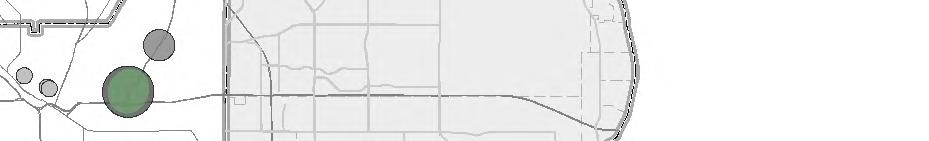
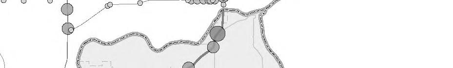

76 )l!"`$ Legend Intersections Meeting Volume Criteria I Washington County Locally Identified Future Grade Separation %&c( Recent or Funded Grade Separation Planned Roads %&h(?ça@ Entering AADT Phase II Study Area Map Document: \\arcserver1\gis\metc\t \esri\maps\ics_mapbook5_phaseiistudyarea_washington_85x11p.mxd Date Saved: 2/18/2016 8:53:37 AM %&f(?ta@? A@ ËGH )p?øa@ E±GH )s %&f(?øa@!"b$ )s Miles Source: MetroGIS, MnDOT Figure 9 Washington County Phase II Study Areas February 2016