Feather River Coordinated Resource Management Watershed Restoration Monitoring
|
|
|
- Angelica Long
- 5 years ago
- Views:
Transcription

1 Feather River Coordinated Resource Management Watershed Restoration Monitoring Plumas-Lassen Administrative Study Research Seminar April 21, 2011 Kara Rockett
2 Feather River CRM Signatory Agencies 24 Federal, state and local, public and private agencies and groups Plumas National Forest Natural Resource Conservation Service North Cal-Neva Conservation and Development Area US Army Corps of Engineers USDA Farm Services Agency US Fish & Wildlife Service Feather River RCD Feather River College PG&E Salmonid Restoration Federation Trout Unlimited Plumas Corporation Department of Conservation Calif. Dept. Fish & Game Calif. Dept. Forestry & Fire Protection State Parks and Recreation Calif. Dept. of Transportation Calif. Dept. Water Resources Regional Water Quality Control Board UC Cooperative Extension Sierra Valley RCD Plumas County Plumas County Community Development Commission Plumas County Unified School District


3 Feather River CRM Mission Statement To protect, maintain and enhance ecosystems and community stability in the Feather River Watershed through collaborative landowner participation. 3,222 sq mi


4 Restoration FRCRM focus- Reestablishing stability and proper hydrologic function in headwater meadows by reconnecting channels with historic floodplains. Techniques: Boulder Vane Bank Stabilization Riffle Augmentation Pond and Plug

5 FR-CRM Restoration 1985 present 67 projects completed 47 miles of channel 4100 acres of meadow Project distribution One or more meadow projects have been implemented in 11 of the 15 groundwater basins in the Upper Feather River (DWR)

6 Monitoring & Modeling Watershed Level Streamflow (continuous since 1999) Water Temperature Turbidity Stream Condition Inventory Project Level Groundwater Level Water Temperature Stream Condition Inventory Soil Moisture Stream Flow Turbidity Wildlife Carbon Vegetation Continuous Recording Station on Spanish Creek at Dyrr Bank

7 FRCRM Watershed Monitoring Sites
8
9

10
11 Project Monitoring

12 Red Clover Creek project inflow, 5/5/2009; Turbidity - 35 NTU

13 Red Clover Creek project outflow, 5/5/2009; Turbidity - 3 NTU

14
15

16 Bankfull discharge
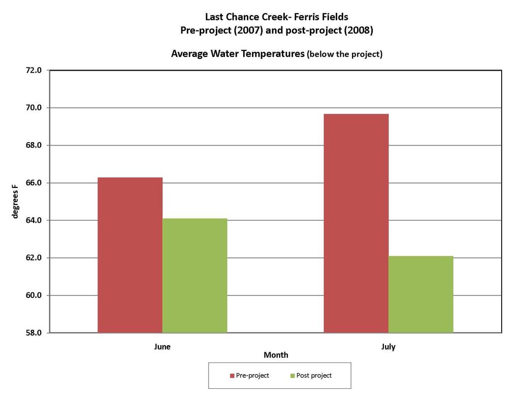
17 Clarks Creek Restoration Project Maximum Weekly Average Water Temperature Above Project 80.0 Below Project 66 F 70.0 Inflow Stops 6/27/08 Outflow Stops 7/26/08 Temperature (F) Date
18
19 (% is percent (% is percent of of annual normal average precipitation) precip.) - Meadow elevation -


20

21 Red Clover Total Forage Production
22

23

24

25 Cottonwood Creek, Big Flat Sample Date Name/Length of Stream Sampled Species Total Catch Population Estimate/mile Biomass/mile 5/23/2000 Big Flat-100 feet Rainbow Trout 60 1,126 45,700 m/l 5/24/2000 Clarks Creek-100 feet Rainbow Trout ,700 m/l

26

27


28 Red Clover- McReynolds Creek Project Avifauna Monitoring ( ) Bird Species Diversity- 64 species in 2004/122 species in 2008 Species richness- Increased from 26.7 species to 30.3 species Wetland/Riparian obligates- 30 species only occurring post-project Special status species- 12 species only occurring post-project Neotropical migrant songbirds- 34% of total avifauna species

29 Wilson s phalarope (Phalaropus tricolor)
30 Waterfowl Population Results 9 waterfowl species observed using the study area preproject. Of these nine only three were observed breeding: Mallard (Anas platyrhynchos), green-winged teal (Anas crecca), and common merganser (Mergus merganser) 18 waterfowl species observed post-project Of these, eight were observed breeding: Bufflehead (Bucephala albeola), gadwall (Anas strepera), greenwinged teal (Anas crecca), blue-winged teal (Anas discors), mallard (Anas platyrhynchos), Canada goose (Branta canadensis), common merganser (Mergus merganser), pied-billed grebe (Podilymbus podiceps

31


32
33 Partner Point Count Monitoring

34
35 Monitoring Conclusions Working towards more rigorous statistical analysis of our watershed wide stream flow and water temperature data Monitoring is driven by funding All monitoring data can be found on our website: