Guna Paudyal WMO Global Hydrological Status and Outlook System (HydroSOS) September 26-28, Entebbe, Uganda
|
|
|
- Dennis Holland
- 5 years ago
- Views:
Transcription
1 Hindu Kush Himalayan Hydrological Cycle Observing System (HKH-HYCOS) Guna Paudyal WMO Global Hydrological Status and Outlook System (HydroSOS) September 26-28, Entebbe, Uganda
2 Outline The HKH-Region: Flood issues HKH-HYCOS Programme: - Pilot Real Time Observation System - Regional Flood Information System - Regional Flood Outlook - Transboundary Flood Outlook-Koshi R.

3 The HKH region: flood issues The KHK region consists of large river basins of China (Tibet), Afghanistan, Pakistan, Nepal, Bhutan, Nepal, India & Bangladesh The Ganges and Brahmaputra are two very large river systems of South Asia with a catchment are of 1.5 million sq. km.


4 Out of a total population of over 1 billion in HKH region, 500 million are poor and disadvantaged. Millions of people suffer from annual floods which are widespread and of transboundary in nature, thousands loosing lives. Damages to infrastructure in billion dollars Alarmingly significant loss of livelihoods
5 The recent Floods of 2017 were devastating in South Asia: 800 people killed, 240 million affected, National Governments & International agencies have spent billions of dollars in structural flood mitigation, but with limited success. It has now been realized that monitoring of hydro-met events and providing forecasts and early warning can play an effective role in reducing the impacts of flood disasters. => HKH-HYCOS Programme initiated in 2012 by the International Center for Mountain Development (ICIMOD) with cooperation from WMO.
6 Five major components: HKH-HYCOS programme: 1. Framework for cooperation 2. Establishment of Regional flood observation network 3. Development of Regional flood information system 4. Development of Transboundary Flood Outlook 5. Creating Public awareness & capacity building


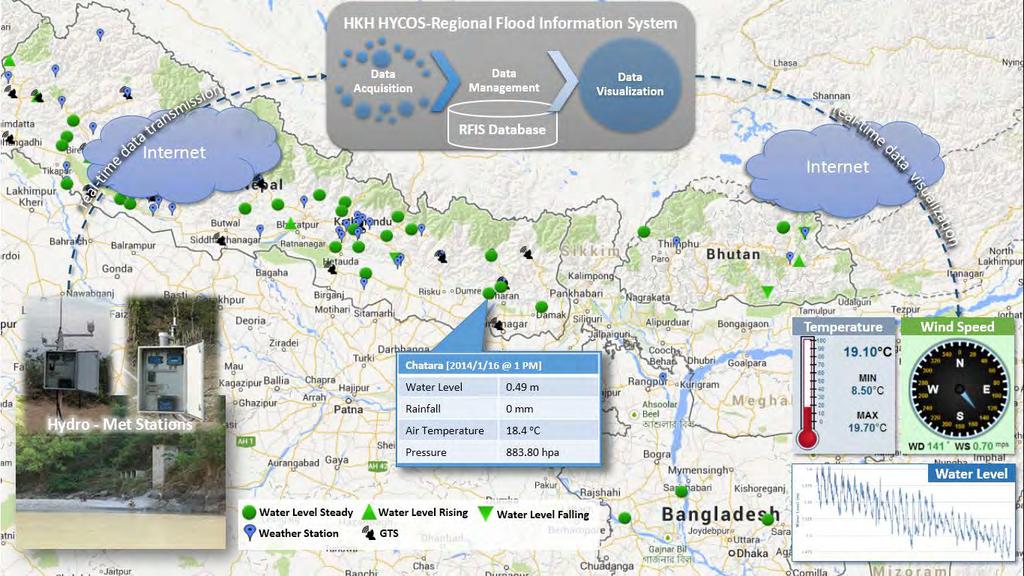
7 The overall process National FF Services Field real-time hydrometeorological data acquisition Field sensor Raw data Preliminarily processed data Data processing National flood information systems Regional Flood Information System Regional Centre, ICIMOD Other data Forecast data Regional flood outlook (P, WL, Q) Other data acquisition Hydrometeorological (GTS etc.) Soil, Land cover, river schematics SRE, QPF, Weath. Forecast, snow cover etc.
8 HKH-HYCOS

9 Overall Objectives of The HKH HYCOS: to minimise the loss of lives and property by reducing flood vulnerability in the HKH region Making Information Travel Faster than Flood Waters

10 Observation network 33 real time hydro-met stations and data sharing installed in four countries (Bangladesh, Bhutan, Nepal & Pakistan)


11 INDIA Bangladesh HYCOS Real Time Radar WL Old manual gauge

12
13 Regional flood Outlook The Ganges- Brahmaputra Basin (G-B) as a pilot system 1.50 million sq.km


14 Basin Ganges Brahmaputra Rivers Catchments Combination of real time observations and Satellite rainfall estimates


15 The Overall Regional Flood Outlook system National RTDAS HKH HYCOS DATA BASE Historical Data Real Time Data Forecasting Model WEB data QPF Metforecasts Calibrated Flood Model COMMUNICATION Real-time Flood Information National & regional flood information portals


16 The outlook which, in essence, is a regional flood forecast based on a mathematical model describing the precipitation-runoff process in the catchments and hydrodynamic flood routing along the river system.


17 Case study: August 2014 GFS rainfall forecast on 12 th Aug :00 14 Aug 15 Aug 16 Aug Pilot regional flood outlook results 2014 Legend Danger Level Alert Level Monthly average Level
18 Operational forecasts : 2014 (major river basins of Nepal)


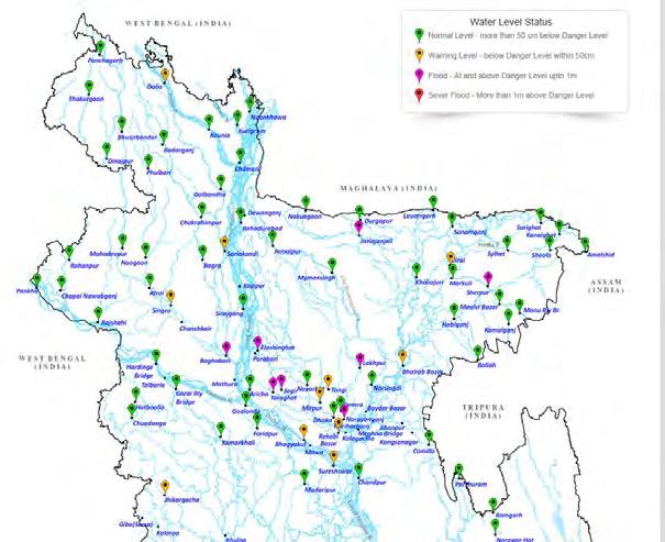
19 Dissemination of Flood Outlook

20 Tabular view of forecast


21 Forecast lead time for Bangladesh
22 Impact of The HKH-HYCOS programme: National Governments inspired to install over 500 real time hydro-met stations in Nepal, Bhutan, Pakistan, Bangladesh (World Bank and UNDP actively supporting) Development of National Flood Information systems including real time flood forecasting and early warning systems Benefits of Regional Data sharing and transboundary flood information being realized by the riparian countries. Regional Transboundary flood outlooks used in flood disaster management Lower riparian countries using the regional flood outlooks in increasing lead time of flood forecasts. Regional and National capacities improved in flood monitoring, modelling & in dissemination of community based early warning Improved awareness, reduced loos of lives during heavy floods (2017)
23 Thank you Slide 23