Restoration Training
|
|
|
- Cecilia Welch
- 5 years ago
- Views:
Transcription
1 Paraprofessional Watershed Restoration Training March 19, 2014 Room 223, Environmental Sciences Building New Brunswick, NJ Christopher C. Obropta, Ph.D., P.E. t Jessica Brown, EIT


2 What is stormwater? Stormwater is the water from rain or melting snows that can become runoff, ff flowing over the ground surface and returning to lakes and streams.


3 1. What is a watershed? 2. Where does precipitation it ti go? 3. Land Use/Land Cover Changes 4. Nonpoint Source Pollution 5. How can we better manage stormwater? OVERVIEW
4 WHAT IS A WATERSHED? An area of fland that water flows across, through, h or under on its way to a stream, river, lake, ocean or other body of water. A watershed is like one big bathtub... Do you know what a watershed is? Courtesy of Texas Watershed Stewards, Texas A&M AgriLife Extension


5 HYDROLOGIC CYCLE Courtesy of


6 WHERE DOES PRECIPITATION GO? 1. It can run off C t f T W t h dst d T Courtesy of Texas Watershed Stewards, Texas A&M AgriLife Extension


7 WHERE DOES PRECIPITATION GO? 2. It can be absorbed by plants and used for photosynthesis and other biological processes Courtesy of Texas Watershed Stewards, Texas A&M AgriLife Extension
8 WHERE DOES PRECIPITATION GO? 3. It can infiltrate through the soil surface and percolate downward to groundwater aquifers Courtesy of Texas Watershed Stewards, Texas A&M AgriLife Extension


9 WHERE DOES PRECIPITATION GO? 4. It can evaporate Courtesy of Texas Watershed Stewards, Texas A&M AgriLife Extension


10 The Impact of Development on Stormwater Runoff 10% 20% 30% 55% More development More impervious surfaces More stormwater runoff
11 LAND USE/LAND COVER CHANGES LAND USE HOW LAND IS USED BY HUMANS: AGRICULTURE INDUSTRY URBAN RESIDENTIAL RECREATION LAND COVER BIOLOGICAL AND PHYSICAL FEATURES OF THE LAND: FORESTS GRASSLANDS AGRICULTURAL FIELDS RIVERS, LAKES BUILDINGS, PARKING LOTS
12 LAND USE/LAND COVER CHANGES Courtesy of Texas Watershed Stewards, Texas A&M AgriLife Extension
13 The Urban Hydrologic Cycle
14 Combined Sewer Systems (CSOs)
15 WATER POLLUTION SOURCES POINT SOURCE POLLUTION NONPOINT SOURCE POLLUTION Environmental Health Perspective, National Institute of Health


16 POINT SOURCE POLLUTION Comes from a specific source, like a pipe Factories, industry, municipal treatment plants Can be monitored and controlled by a permit system (NPDES)
 Associated with")


17 NONPOINT SOURCE POLLUTION (NPS) Associated with stormwater runoff Runoff collects pollutants on its way to a sewer system or water body Itcannot be traced to a direct discharge point such as a wastewater treatment facility


18 EXAMPLES OF NPS Oil and grease from cars Sewage leaks Fertilizers Household cleaning products Animal waste Litter Grass clippings Agriculture Septic systems Sediment
19 Impacts from Changing g the Hydrologic Effects: Landscape Disruption of natural water balance Increased flood peaks Increased stormwater runoff More frequent flooding Increased bankfull flows Lower dry weather flows


20 History of Stormwater Management


21 1 st Attempt at Stormwater Management Capture all runoff, pipe it, and send it directly to the river...prior to mid 1970 s
 or 36 hours (commercial) Reduce downstream flooding during major storms Use concrete low flow")

22 2 nd Iteration of Stormwater Management Capture runoff, detain it, release it slowly l to the river mid id 1970 s to 2004 Detain peak flow during large storm events for 18 hours (residential) or 36 hours (commercial) Reduce downstream flooding during major storms Use concrete low flow channels to minimize erosion, reduce standing water, quickly discharge low flows Does not manage runoff from smaller storms allowing stormwater t to pass through h the system Directly discharges stormwater runoff to nearby stream, waterway, or municipal storm sewer system (at a controlled/managed rate)


23 3 rd Generation of Stormwater Management Reduce stormwater t runoff volume Reduce peak flows and flooding and. Maintain infiltration and groundwater recharge Reduce pollution discharged to local waterways abc Action News, August 27, 2012

24 How NJ s regulations change the way we manage stormwater Play
25 Stormwater Management
26 It is all about controlling runoff from impervious surfaces
27 The Hydrologic Cycle
28 We must deal with impacts from impervious cover Are there impervious surfaces that you can eliminate? If we can't eliminate it, can we reduce it? If we can't eliminate or reduce it, can we disconnect it? Are there impervious surfaces that you can harvest rainwater for reuse? Are there conveyance systems that can be converted to bioswales?
29 Eliminate it!
30 Underlying stone reservoir Reduce It! Pervious Pavements Porous asphalt and pervious concrete are manufactured without t "fine" " materials to allow infiltration Grass pavers are concrete interlocking blocks with open areas to allow grass to grow Ideal application for porous pavement is to treat a low traffic or overflow parking area
31 Pervious Pavements FUNCTIONS COMPONENTS Manage stormwater runoff Minimize site disturbance Promote groundwater recharge Low life cycle costs, alternative to costly traditional stormwater t management methods Mitigation of urban heat island effect Contaminant removal as water moves through layers of system
32 Pervious Pavement
33 Pervious Pavements
34 Disconnect It!
35 For 1.25 inch storm, 3,811 cubic feet of runoff = 28,500 gallons 1 acre directly connected impervious cover Total drainage area = 3 acres 2 acres pervious cover Runoff Direction Stormwater Ilt Inlet
36 For 1.25 inch storm, 581 cubic feet of runoff = 4,360 gallons 1 acre directly connected impervious cover Total drainage area = 3 acres 2 acres pervious cover Runoff Direction Stormwater Ilt Inlet
37 Volume of Runoff Design Connected Disconnected Percent Storm (gallons) (gallons) Difference 1.25 inches (water quality storm) 28,500 4,360 85%


38 Disconnection with Rain Water Harvesting Disconnect your downspout by installing a rain barrel Impervious area is now disconnected from flowing directly into the storm sewer system
39 So Many Barrels to Choose From


40 Or Larger Rainwater Harvesting Systems
41 Disconnection with Rain Gardens R ft ff i di t d f Rooftop runoff is now disconnected from flowing directly into the storm sewer system


42 Lots of Rain Gardens


43 Green Gee Infrastructure astuctueis... an approach to stormwater management that is cost-effective, sustainable, and environmentally friendly. Green Infrastructure projects: capture, filter, absorb, and reuse stormwater to maintain or mimic natural systems and treat runoff as a resource.


44 Green Roofs Green Infrastructure includes: Rainwater Harvesting Planter Boxes Rain Gardens Permeable Pavements Vegetated Swales Natural Retention Basins Trees & Urban Forestry Brownfield Redevelopment
45 Rainwater Harvesting FUNCTIONS Collecting, filtering and storing water from roof tops, paved and unpaved areas for multiple uses. Harvested water can be used for nonpotable or potable purposes after testing and treatment. Surplus water after usage can be used for recharging ground water. Systems can range in size from a simple PVC tank or cistern to a contractor designed and built tank/sump with water treatment t t facilities.


46
47 Rainwater Harvesting Samuel Mickle School Rainwater Harvesting System
48 Green Roofs FUNCTIONS Improves stormwater t management Improves air quality Temperature regulation (moderation of Urban Heat Island Effect) Carbon dioxide/oxygen exchange Increased urban wildlife habitat COMPONENTS


49 Green Roof Design Modular System Specifications: Parker Urban Greenscapes


50 Pervious Pavements Underlying stone reservoir that temporarily stores surface runoff before infiltrating into the subsoil Porous asphalt and pervious concrete are manufactured without "fine" materials, and incorporate void spaces to allow infiltration Grass pavers are concrete interlocking blocks or synthetic fibrous grid systems with open areas designed to allow grass to grow within the void areas Ideal application for porous pavement is to treat a low traffic or overflow parking area


51 Pervious Pavements FUNCTIONS COMPONENTS Manage stormwater runoff Minimize site disturbance Possibility of groundwater recharge Low life cycle costs, alternative to costly traditional stormwater t management methods Mitigation of urban heat island effect Contaminant removal as water moves through layers of system
52 Pervious Pavement
53 Pervious Pavements
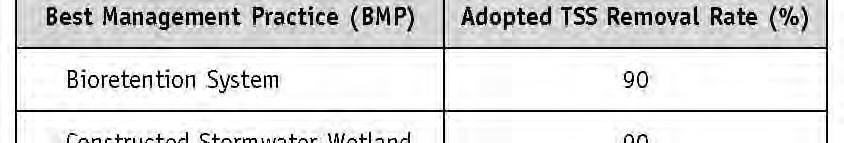
54 Bioretention Systems & Rain Gardens Traditional Approach Design Dry Detention Basin: Treat Water Quality Storm (1.25 rain over 24 hours) Detain for 18 hours (residential) or 36 hours (commercial) Minimum outflow orifice = three inches Use Concrete Low Flow Channels to Minimize Erosion New Approach Combines settling of detention basin with physical filtering and absorption processes Provides very high pollutant removal efficiencies More aesthetically pleasing than conventional detention basins Can be incorporated into the landscapes of individual homes
55 Bioretention Systems & Rain Gardens NJDEP NJ Stormwater BMP Manual.
56 Bioretention Systems & Rain Gardens
57 Curb Extensions/Green Streets


58
59 BREAK Let s go outside!
60 It is all about controlling runoff from impervious surfaces


61 We must deal with impacts from impervious cover Are there impervious surfaces that you can eliminate? If we can't eliminate it, can we reduce it? If we can't eliminate or reduce it, can we disconnect it? Are there impervious surfaces that you can harvest rainwater for reuse? Are there conveyance systems that can be converted to bioswales?
62 Paraprofessionals Here is what you re gonna do!
63 Desktop Analysis
64 R1 R2 R3 R5 R4
65
66 Site Visits
67 Site Visit Checklist Organized route with directions Camera! Measurement tools tape measure comes in handy! Aerials Notes pages pg Contact information for Site Owner List of constraints to refer to A friend to go with
68
69
70 Document Recommendations
71
72
73
74 Quantify Load Reductions of Proposed BMPs? Based upon land use of your site, determine pollutant loads from site and amount of runoff. Based upon ability of recommended BMP to reduce pollutants, determine amount of pollutant t load to be reduced by recommended BMPs. Put it in an easy to read table DEP likes Put it in an easy to read table DEP likes that.
75
76
77
78 Pollutant Load Reductions for Royce Brook Project Aerial Loads Loads Reductions in Loads Site Area TP TN TSS TP TN TSS TP TN TSS (acres) (lbs/ac/yr) (lbs/ac/yr) (lbs/ac/yr) (lbs/yr) (lbs/yr) (lbs/yr) (lbs/yr) (lbs/yr) (lbs/yr) R Stormwater Treated and Infiltrated by BMP: 12,300 square feet * 44 inches * ft/12in * 0.90 = 40,590 cu.ft. 40,590 cu.ft. * 7.48 gallons per cubic foot = 303,613 gallons
79 Picture is worth 1,000 words
80
81 How this can be used to develop plans? Develop an Impervious Cover Reduction Action Plan Develop a Watershed Restoration Plan
82 How the plans can be used to implement projects? Implementing community projects Developing local ordinances Identification of mitigation for new development and redevelopment
83 Stormwater Mitigation Plan Online Tool
84 Zooming In...
85 An Example
86 What would you design for this site?
87 Observations Lots of impervious i cover No stormwater management Lots of open space for potential BMPs Questions Are there downspouts? Are they connected? Is there curb along the parking lot? Which way is the parking lot graded? What is the condition of the parking lot?
88 Other Questions Do the soils around the Ag Museum infiltrate? t Who own the property? Will they be open to installing stormwater management measures? Are there potential partners to help with the project? Do we need permits for altering this site with stormwater best management practices? Does the building have a basement? Can we lose parking spaces? Who will maintain i the BMPs? Is the project a high priority?
89 Soil Considerations Web Soil Survey (websoilsurvey.nrcs.usda.gov)
90 Map Unit Name Acres in AOI Percent of AOI FarAr MbrA MbuA NkrB Fallsington bedrock substratum variant loam, 0 to 2 percent % slopes, rarely flooded d Matapeake silt loam, 0 to 2 percent slopes % Mattapex silt loam, 0 to 2 percent slopes % Nixon moderately well drained variant loam, % 2 to 5 percent slopes Totals for Area of Interest %
91 FavAr Fallsington bedrock substratum variant loam, 0 to 2 percent slopes, rarely flooded Map Unit Composition Fallsington variant, bedrock substratum, rarely flooded, and similar soils: 85 percent Properties and qualities Slope: 0 to 2 percent Depth to restrictive feature: More than 80 inches Drainage class: Poorly drained Capacity of the most limiting layer to transmit water (Ksat): Moderately low to moderately high (0.06 to 0.20 in/hr) Depth to water table: About 0 to 12 inches Interpretive groups Hydrologic Soil Group: D
92 Sewage Disposal (NJ) Map unit symbol Rating Rating reasons (numeric values) Depth to perched zone of saturation (1.00) FavAr Very Restrictive substratum (1.00) limited Restrictive horizon (1.00) Not Permitted - Flooding (1.00) Not Permitted - Hydric Soil (1.00) MbrA MbuA NkrB Not limited Somewhat Depth to apparent zone of limited saturation (0.83) Somewhat Depth to apparent zone of limited saturation (0.83)
93
94 Presenting the information
95 Presenting Data 1. Consider the audience 2. Make sure you have something to present! 3. Organize data in Watershed Management Plan format even if pieces are missing 4. Create a standard PowerPoint. 5. Provide handout/samples 6. Take a friend/call RCE
96 Consider the Audience Host Agency School kids NJDEP Environmental Commissions, i Planning Boards Watershed Planning Advisory Committee What are your goals of presenting the data? Assistance? Marketing support? Awareness?
97 Make sure you have something to present


98 Make sure you have something to present


99 Organization of data Create a standard PowerPoint and handouts
100 Resources Available to You

 edu) Lisa Galloway")
 Steve Yergeau")
 Kyle Gourley")
 g http://www.water.")
101 Resources Available to You Jessica Brown edu) Lisa Galloway Evrard Steve Yergeau Kyle Gourley g


102 Resources Available to You professionals/paraprofessionals.html
103 PICK A WATERSHED OR A MUNICIPALITY
104 QUESTIONS?