WATER YEAR BOOK 2013
|
|
|
- Godwin Hill
- 5 years ago
- Views:
Transcription


1 Government of Chhattisgarh WATER RESOURCES DEPARTMENT WATER YEAR BOOK 2013 Deputy Director Hydrometeorology Dn. No. 4 Raipur Superintending Engineer W.R.&GWS Circle Raipur Chief Engineer Mahanadi Godavari Basin Raipur
2 Chhattisgarh Water Year Book 2013 CHIEF ENGINEER/PROJECT CO-ORDINATOR HP-II MAHANADI GODAWARI BASIN WATER RESOURCES DEPARTMENT GOVERNMENT OF CHHATTISGARH RAIPUR FOREWORD The increasing demand for water from all sections of society has put the supply system in a stressful situation. The selection of choices is reducing drastically, as so called cheap water is not more reality. This necessitates the need for understanding the facts about water availability, its use by different groups and evolving optimized solution on equitable basis so that everybody is given his/her due share. The information on rainfall, river discharges and meteorological parameters as well as on surface water quality plays vital role in deriving sustainable solution to the water problem. This document of water yearbook is a sample of what kind of data available with the State Data Storage Center (SDSC) Raipur, Those who are interested in getting detailed data on a particular parameter in a particular area can obtain the data as per prescribed procedure. Dy. Director Hydrometeorology Division Raipur has prepared this water yearbook, which is the backbone of validation and hence play a great role in making available the factual data. I appreciate and would like to put on record the efforts taken by Mr. S. K. Awadhiya Superintending Engineer Water Resources & Ground Water Survey Circle Raipur and Mr. D. K. Sonkusale (Dy. Director Hydrometeorology Division No. 4 Raipur) and his team for bringing out this water year book. Raipur January 2014 (R. N. Divya) Chief Engineer I
3 Chhattisgarh Water Year Book 2013 SUPERINTENDING ENGINEER/NODAL OFFICER HP-II WATER RESOURCES & GROUND WATER SURVEY CIRCLE CHHATTISGARH RAIPUR FOREWORD The water yearbook comprises the information regarding water quality & Hydro meteorological field data collection through the network stations established under World Bank aided Hydrology Project, which is ready for dissemination at State Data Storage Center Raipur to the users. An accurate Hydrological Information System (HIS) is being disseminated to the users after complete validation, processing by exclusively trained Hydrologists of the processing as well as storage centers of the State. An accurate HIS information is developed as a result of strict implementation of the standardized protocols for various HIS activities such as station set up, staffing plan, HIS job descriptions, field data collection, O&M of network stations. The Hydrologists & Expert staffs are working with full enthusiasm & seal for timely data dissemination to the users. Mr. D. K. Sonkusale Deputy Director Hydrometeorology Dn. No. 4 Raipur is the key person behind this spectacular picture. It is worthwhile to note here Efforts taken by Mr. Akhilesh Verma Assistant Engineer WR & GWS Circle Raipur, Mr. R. K. Sharma SDO Hydrometeorology Sub Dn. No. 10 Raipur and his team, Mr. R. A. Abbasi Assistant Engineer, Mr. Jayant Dass Sub Engineer of Hydrometeorology Dn. No. 4 Raipur, which resulted into preparation of excellent water yearbook of Hydrology Project for the year Raipur January 2014 (S. K. Awadhiya) Nodal Officer HP II II
4 Preface III Chhattisgarh Water Year Book 2013 With the development of water resources for multipurpose and consumptive use of human society, knowledge of hydrometeorology has become indispensable for computing any kind of hydraulic data, An evaluation of meteorological parameters, measurements of precipitation and run off and inter relation of different climatologically, geographical and topographical characteristics resulting into water yields and floods is a vital and yet complex phenomenon. With the advancement of technology and the society water is fast becoming an essential commodity to meet the varying uses of consumptive and non consumptive uses of water in industries, irrigation water power, navigation etc. It is necessary to measure rainfall and runoff daily at all the key points in each major river valley. Furthermore the data thus collected has to be analyzing to determine water availability at various times in the river. This kind of analysis enables to determine the amount of water to be stored during monsoon period for regular uses during succeeding long dry period and also the amount of carryover required from a wet year to meet deficiencies during any dry year. An accurate HIS information is developed as a result of strict implementation of the standardized protocols for various HIS activities such as station set up, staffing plan, HIS job descriptions, field data collection, O&M of network stations. The most important use of Hydrology in Water Resources Engineering is application of observed, computed and projected data in design and estimation of structure and hydraulics of Reservoirs, Drinking and Industrial water use projects, Irrigation, Power, Flood Control, Navigation, Erosion control and pollution abatement. In order to collect the data in a standard and systematic manner Hydrological net work was formulated under C.G. Major Projects component founded from World Bank Assistance (G 1177 IN) and a post of Director Hydrometeorology was created with Dy. Directors with Head quarters at Raipur; Several G.D. Sites have been commissioned at various stations in the state of Chhattisgarh. Regular training were organized by NIH & WRD CG time to time for good use of software and rainfall estimation & flood control data validation in HYMOS system.
5 Chhattisgarh Water Year Book 2013 The water yearbook comprises the information regarding Hydro meteorological field data collection through the network stations established under World Bank aided Hydrology Project, which is ready for dissemination at state Data Storage Center Raipur to the users. An accurate Hydrological Information System (HIS) is being disseminated to the users after complete validation, processing by exclusively trained Hydrologists of the processing as well as storage centers of the state. Following Hydro meteorological Network are under observation. 27 Rainfall station (SRG) of Hydrology Project & 138 Rainfall station (SRG) of WRD & other Department and 32 Gauge & Discharge site in Mahanadi Basin. 8 Rainfall station (SRG) of Hydrology Project & 12 rainfall station (SRG) of WRD & other Department and 10 Gauge & Discharge site in Godavari basin. 13 rainfall station (SRG) of WRD & other Department in Ganga Basin. 02 Rainfall station (SRG) of WRD & other Department and 01 Gauge & Discharge site in Bramhani Basin. 2 Full Climatic Stations at Sarangpal Kanker & Sakri Bilaspur. 6 water Quality Laboratory. The present book is the Second attempt to publish the Hydro Meteorological observation carried out under World Bank Assistance Hydrology Project and also includes brief description of river basin in Chhattisgarh & Onset and withdrawal trend of South West Monsoon in Chhattisgarh and its effect on Rainfall. The central idea of the water year book is to review and communicates to the target readers, what kind of hydro meteorological and hydrological scenario prevailed in the region during the year under consideration. Various types of data, viz. rainfall, evaporation, river water level and flows can be summarized with the help of graph and data tables. Graphical illustration showing the process during the year under consideration against the long term pattern could be very effective. Together with the graphical illustrations summarizing hydrological and hydro meteorological behavior, it is worthwhile to tabulate the daily data and the important monthly and yearly statistics along with it. Such tabulations enable easy referencing to any particular data at any point of time, without requiring interrogating the database for retrieving the same. D. K. Sonkusale Deputy Director IV
6 Chhattisgarh Water Year Book 2013 Abbreviation ARG CWC CWPRS CPCB CGWB FCS GD GW HDUG HIS HP IMD IST MoWR NIH NWA PDS SW SRG WQ WB WRD Automatic Rainfall Station Central Water Commission Central Water & Power Research Station Central Pollution Control Board Central Ground Water Board Full Climatic Station Gauge & Discharge Site Ground Water Hydrological Data User Group Hydrological Information System Hydrology Project Indian Meteorological Department Indian Standard Time Ministry of Water Resources National Institute of Hydrology National Water Academy Purpose Driven Studies Surface Water Standard Rainfall Station Water Quality World Bank Water Resources Department V
7 WATER YEAR BOOK 2013 INDEX Chhattisgarh Water Year Book 2013 Sr. No. Description Pages 1 Introduction Hydrological Review Meteorological Observation Sites (Rainfall) Meteorological Observation Sites (Climatic) Hydrological Observation Sites Water Quality Sedimentation Statistics Time Schedule for Data Observation 46 9 Data Dissemination Annexure A 1 Map & List of Gauge & Discharge Network Annexure A 2 Map & List of Rainfall Network Annexure A 3 Map & List of FCS Network Annexure B Data Request Form Annexure C List of Data Dissemination Annexure D Sample Output Map Compare Year 2013 & Historical Rainfall Map of Historical ( Rainfall Isohyets VI
8 1. Introduction (Hydrological Information System) Chhattisgarh Water Year Book 2013 Water plays crucial role in socio economic development of the country. Safe drinking water is required for very large and growing population. Water has also become a major constraining factor for the growth of the agricultural and industrial sectors. In contrast, flooding frequently threaten populations and civil structures. Because of competing demands between users, the state requires proper planning, design and management of water resources and water use systems. The availability of an efficient and comprehensive Hydrological Information System (HIS), comprising a reliable database on all aspects of the hydrological cycle, is a prerequisite for such planning, design and management, to arrive at better decisions as well as to achieve efficiency. The Hydrological Information System provides information about Hydrological and Hydro meteorological parameters that vary with respect to time and space. The information is regularly updated so that the decisions/policy makers, designers and researchers can use this information to make decisions for long term planning, design or can study the water resources system at large or its components. Earlier, Water Resources Department (Govt. of MP/CG) was collecting the Hydrological Information System (HIS) Data and was recording manually in the form of registers for the use of Water Resources Department only. In 1995 National Hydrology Project was established in collaboration with MoWR (Ministry of Water Resources Government of India), CWC, CGWB, National Institute of Hydrology (Roorkee), CWPRS (Pune) CPCB, India Meteorological Department, with Nine States i.e. Maharashtra, Orissa, Tamilnadu, Madhya Pradesh, Chhattisgarh, Andhra Pradesh, Gujarat, Karnataka & Kerala to develop sustainable HIS information with following characteristics. Demand driven i.e. output is as per the user s needs. Use of standardized equipments and adequate procedures for data. Collection and processing. Computerized, comprehensive and easily accessible database. Proper infrastructure to ensure sustainability. 1
9 Chhattisgarh Water Year Book 2013 Under this project since 1995, Hydrology Project Surface Water (SW), Water Resources Department, MP/CG State has started to collect the data on these lines and entering it in electronic mode to process it at Primary validation in Sub Division, Secondary validation in Division Office, then Hydrological validation in State Data Processing Center Raipur. Interagency partial validation is carried out with Central Water Commission and India Meteorological Department for accuracy and quality. Such finally validated data is then stored in State Data Storage Center, Raipur to make it available to Hydrological Data Users online/offline with nominal cost. Before National Hydrology Project, State Government was preserving every year rainfall as well as Gauge Discharge data in discrete manner in a shape of hard copy. Now Water Year Book is made available in electronics format (on CD) as well as in hard copy. This water year book contains graphs showing isohyets map of rainfall, Time series graph of rainfall, Discharge, & Evaporation, Flood Hydrographs, etc. to get hydrometeorology of the region to the readers and intended users. The sample graphical representation of data given in this water year book gives just an idea of type of data available with this organization. Intended data user can obtain the requisite data from the data available with this organization after depositing requisite fees. The water year book includes the information of the hydrometeorological regime of the Chhattisgarh. 1. Brief description of river basin in Chhattisgarh 2. Onset and withdrawal trend of South West Monsoon in Chhattisgarh and its effect on Rainfall 3. Rainfall events of year 2013 in the Chhattisgarh 4. Average District wise rainfall from year 1975 to 2012). 5. Basin wise daily maximum & annual minimum rainfall in Chhattisgarh state. 6. Year 2013 Rainfall Isohyets & Thiessen Polygon. 7. Water Quality result of year Sedimentation Studies in Kodar Reservoir Some significant trends in rainfall and flow of rivers in the State have been included in this water year book to know about the trends of rainfall & flow pattern of rivers. 2
10 Chhattisgarh Water Year Book 2013 The idea of preparing and publishing water year book is to communicate the intended data users, the kind of meteorological and hydrological scenario prevailed in the basins of the state during the hydrological year under consideration. Hydro meteorological and river gauging network is also included in this water year book in the form of maps and list of the stations (Annexure A). Various types of data i.e. rainfall, river water levels, runoff (computed), maximum, minimum, dry bulb, wet bulb temperature, humidity, wind speed, wind direction, pan evaporation, pan water temperature and sunshine duration have been summarized with the help of graphs and data tables. The intended users can have these data from data bank as per the procedure laid down. Analysis of data is illustrated basin wise and basin is the unit for presentation of this data for Chhattisgarh state. X 3
11 4 Chhattisgarh Water Year Book 2013
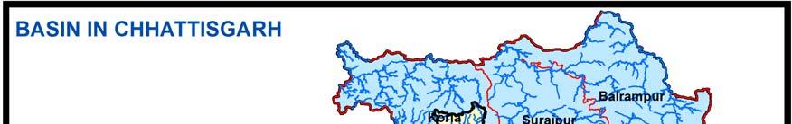
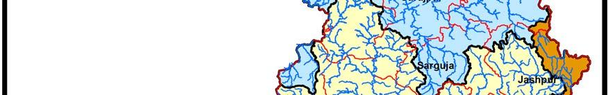
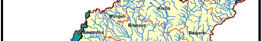


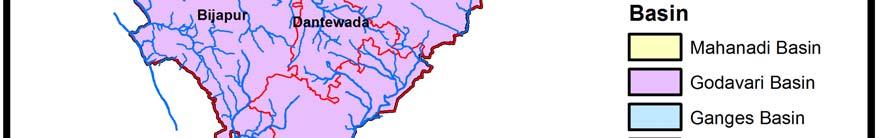

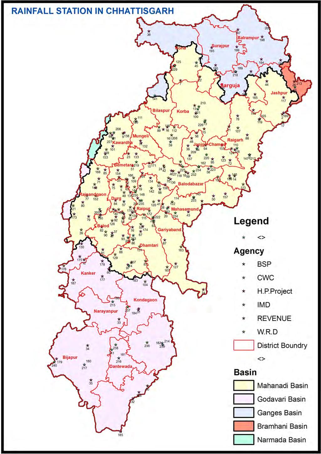
12 2. Hydrological Review Chhattisgarh Water Year Book Basin of Chhattisgarh Figure 2.1 Basin Map of Chhattisgarh 5
13 Chhattisgarh Water Year Book 2013 Nature is very kind to Chhattisgarh in terms of rainfall as compared to several other states of the Union. Average rainfall in the state is around 1200mm. and about 90% of the total rainfall is confined in the Monsoon season i.e. 15 th June to 15 th October. The rainfall has erratic temporal and spatial distribution in the state. Due to this variation in the rainfall, the agriculture production of the state, which is mainly Paddy, is affected. In fact; every third year, there is always a threat of drought, which is due to uneven occurrence of rainfall rather than deficient rain. It is obvious that irrigation is the prime need of the state. Mahanadi River is an Inter state river system originating from Chhattisgarh and falling through Orissa to join the Bay of Bengal. Out of total drainage area of 1,35,097 sq. km. of the Mahanadi River about 53% lies in the State of Chhattisgarh and rest in the State of Orissa. About 44% of it is covered with forests. The total geographical area of the Chhattisgarh State is 135,097 Sq. Kms. and state can be divided into five river basins shown in figure 2.1 & Table 2.1 S. No. Basin Area in SqKm % area of State District covered Fully 1 Mahanadi Basin Godavari Basin Ganga Basin Bramhani Basin Narmada Basin Partial Total Table 2.1: * Basin wise Geographical Area of Chhattisgarh as per GIS DISTRICTWISE AREA OF RIVER BASINS IN CHHATTISGARH * Area in SqKm S.No District Ganga Basin Bramhani Mahanadi Narmada Godavari Total Basin Basin Basin Basin 1 Baster Kondagaon Narayanpur
14 Chhattisgarh Water Year Book Bilaspur Mungeli Bijapur Dantewada Sukma Dhamatari Durg Balod Bemetara Janjgir Champa Jashpur Kanker Kawardha Korba Koriya Mahasamund Raigarh Raipur Balodabazar Gariyaband Rajnandgaon Sarguja Surajpur Balrampur Total Percentage
15 Chhattisgarh Water Year Book Brief Description of River Basin 2.21 Mahanadi Basin: River Mahanadi Originates from Sihawa Mountains about 100 Km, South East of Dhamtari towns in District Dhamtari region in the state of Chhattisgarh at an elevation of about m above mean sea level near village Nagri, River Mahanadi flows in North west direction for the initial length of about kms and after passing 375 Km through the Chhattisgarh State, it flows in Orissa State and after travelling total 851 Km finally it fall in the Bay of Bengal near Katak. The catchment area of this basin in Chhattisgarh is SqKm, thus the contribution is % of the Chhattisgarh State. The Characteristics of main tributaries are as under : 1. Seonath: The river originates near village Markaskasa of Maharashtra State near Chhattisgarh Border. It flows initially from West to East the North east, North and finally again South east, and joins river Mahanadi near Seorinarayan a town in District Bilaspur. The catchment area of this sub basin is 30,800 SqKm. thus its contribution is to the tune of about 40.60% i.e. maximum for the Mahanadi Basin. It joins Mahanadi River after running a length of about 383 kms. Its main tributaries are Tandula, Kharun, Amner, Surhi, Hamp, Arpa and Lilagar etc. 2. Jonk: This river originates from State Orissa, near village Amamara of District Mahasamund Chhattisgarh. More or less it travels South to North and joins river Mahanadi near village Kharidih of the Mahasamund District. It s catchment area is SqKm, thus the contribution is only 3.20% which is minimum of the all of the major tributaries of the Mahanadi river. It travels about 196 kms. from it s origin to the confluence where it joins river Mahanadi near Seorinarayan. 3. Hasdeo: This river originates near village Biharpur District Koriya of Chhattisgarh. It travels originally south west then south east and later on it joins to river Mahanadi near village Bamnidih of Janjgir Champa District of Chhattisgarh. Total length of the river is about 333 Km. and its main tributary is river Gej. The total catchment area of this river is 10, SqKm, thus the contribution is 13.9 % to the Mahanadi basin with in Chhattisgarh State. 8
16 9 Chhattisgarh Water Year Book Mand: It originates from village Bargidih of District Sarguja of Chhattisgarh state. It runs about 164 Km from its origin to confluence point, where river Mahanadi near village Aapos Padigaon of District Raigarh/Janjgir Champa. Initially it travels north south then east west and later on again north south and south east. The total contributes area is 5, SqKm thus it contributes only 7.35% towards Mahanadi basin with in Chhattisgarh State. 5. IB & Kelo: The river IB originate from village Pendrap at of District Jashpur initially it travels south east and flows on north south before it joins river Mahanadi near town Belpahad of Orissa state. The total catchment area including Kelo etc. comes out to be SqKm i.e. 8.20% of the total catchment area of the Mahanadi Basin Godavari Basin: Godavari originates from the Sahyadris near Trimbakeswar, about 80 km from the shore of Arabian Sea, at an elevation of 1,067 m in the Nasik district of Maharashtra. After flowing for about 1,465 km in a general south easterly direction through Maharashtra and Andhra Pradesh, Godavari falls into the Bay of Bengal north of Rajahmundry. The basin lies between latitudes N and ` N longitudes E and E. The basin extends over an area of 312,813 Sq km, which is nearly 10% of the total geographical area of the country. Out of the total basin area of 312,813 Sq km, the major parts of the basin fall in Maharashtra state. Further, about Sq km which is only 12.36% of the basin area falls in the Chhattisgarh state. The contribution is % of the Chhattisgarh State Ganga Basin: The catchment area of the Ganga lies between east longitudes to 89 0 and north latitudes to which falls in four countries, namely India, Nepal, Tibet (China), and Bangladesh with major part in India. The Ganga basin extends over an area of 1,086,000 Sq km. The drainage area lying in India is 862,769 Sq km which is nearly 26.2% of the total geographical area of the country. Out of the total basin area about 18, Sq km which is only 1.70 % of the basin area falls in the Chhattisgarh State under tributary Son, thus the contribution is 13.62% of the Chhattisgarh State.
17 Chhattisgarh Water Year Book Bramhani Basin: The Bramhani Basin lies between latitude 20 28' to 23 35' N and longitude 83 52' to 87 30' E in the districts of Raigarh and Sarguja in Chhattisgarh, Ranchi and Singhbhumi in Jharkhand and Sundergarh, Deogarh, Sambalpur, Angul, Dhenkanal, Keonjhar, Jajpur and Kendrapara in Orissa. Brahmani basin is situated between Mahanadi Basin (on the right) and Baitarani Basin (on the left). Chhotanagpur Plateau in the East and South bound the basin, in the north a ridge separates it from Mahanadi basin, and to the east of the basin lie the Bay of Bengal and the Baitarani basin. Out of the total basin area of 39,269 Sqkm, the major parts of the basin falls in Orissa state. Further, about 1, Sqkm which is only 3.55% of the basin area falls in the Chhattisgarh state. The contribution is 1.03 % of the Chhattisgarh State Narmada Basin: The Narmada River, originates from the Amarkantak Plateau of Maikal range in the Shahdol district of Madhya Pradesh at an elevation of 1057 meters above mean sea level at a latitude 22 40' north and a longitude of 81 45' east. The river travels a distance of 1,312 km before it falls into Gulf of Cambay (Khambat) in the Arabian Sea near Bharuch in Gujarat. The Narmada basin extends over an area of 98,796 Sq km and Out of the total basin area about Sq km which is only 0.75% of the basin are falls in the Chhattisgarh state. The contribution is 0.55 % of the Chhattisgarh State. 2.3 Hydro Meteorological Network in Chhattisgarh Hydro meteorological network comprises of 266 Stations, including 21 ARG(HP), 35 SRG(HP), 43 GD, 02 FCS and 165 SRG(Non HP) S.No. Name of Basin ARG (HP Station) SRG (HP Station) GD FCS SRG Non HP Station 1 Mahanadi Basin Godavari Basin Bramhani Basin Ganga Basin Total Table 2.2: Basin wise Hydro meteorological Network ARG : Automatic Rain Gauge SRG : Standard Rain Gauge GD : Gauge and Discharge Site FCS : Full Climatic Station SRG Non HP Station : Other than Hydrology Project which include WRD, Revenue Department. 10
18 3. Meteorological Observation Sites 11 Chhattisgarh Water Year Book 2013 In the monsoon season of India, most of the weather systems that develop in the Indian Ocean and Bay of Bengal passes through Chhattisgarh and gives good amount of monsoon rainfall to this area. Chhattisgarh state is major producer of rice and known as Rice bowl of in India. The production of crop in Chhattisgarh is very much dependent on monsoon rainfall even today as irrigation facilities are limited to a small part of the region nearly 35%. Thus, the rainfall has a great influence on economy of the State. On a regional basis, the transformation of natural land cover by soil cultivation, industrialization and pollution may measurably influence the climate. Thus, man is responsible for altering the climate. India is a big country with geographical variation, therefore climatic variation is also too much. The regional rainfall does not necessarily match with all India rainfall. Farmers are more interested in the weather of their region. Therefore, the regional study is more important to understand the rainfall pattern of state. 3.1 Onset and withdrawal trend of South West Monsoon in Chhattisgarh and its effect on Rainfall (Source: T. Sai Giridhar BIT Raipur) Monsoon is traditionally defined as a seasonal reversing wind accompanied by corresponding changes in precipitation (rain), but is now used to describe seasonal changes in atmospheric circulation and precipitation associated with the asymmetric heating of land and sea. The South West summer monsoon occurs from June to September in India. The Thar Desert and adjoining areas of the Northern and Central Indian subcontinent heats up considerably during the hot summers. This causes a low pressure area over the northern and central Indian subcontinent. To fill this void, the moisture laden winds from the Indian Ocean rush in to the subcontinent. These winds, rich in moisture, are drawn towards the Himalayas. The Himalayas act like a high wall, blocking the winds from passing into Central Asia, and forcing them to rise. As the clouds rise their temperature drops and precipitation occurs. Some areas of the subcontinent receive more than 10,000 mm of rain annually. We will investigate the onset and withdrawal trend of monsoon in Chhattisgarh state during recent period. The district wise map of Chhattisgarh helps

19 Chhattisgarh Water Year Book 2013 us to know about the various Districts of Chhattisgarh and related stations will be undertaken into study for the rainfall pattern. Fig 3.1.1Districtwise map of Chhattisgarh state 12


20 Chhattisgarh Water Year Book 2013 The normal onset date of southwest monsoon in India is shown below in the Fig Fig Similarly, the normal withdrawal dates of southwest monsoon is shown in Fig : Fig
21 Chhattisgarh Water Year Book 2013 Methodology adopted while analyzing was the study of onset trend of 52 years data from 1961 to 2012 taken for three stations i.e. Jagdalpur, Raipur and Ambikapur which covers South, Central and North part of the State. While withdrawal trend of 38 years data from 1975 to 2012 for Chhattisgarh as a whole is taken as it mostly simultaneous. The data was plotted in the graphical format and the observations can be seen in the Fig.3.1.4, Fig.3.5 and Fig Actual onset 20 ACTU Onset date Trend NORM Linear (ACTU Normal ons Fig Onset of monsoon at Jagdalpur Y Fig Onset of monsoon at Raipur Similarly the onset data for the last station (Ambikapur) is plotted into graph shown in Fig
22 Chhattisgarh Water Year Book 2013 ONSET DATE ACTUAL DATE TREND LINE NORMAL DATE YEARS Fig Onset of monsoon at Ambikapur On the basis of the study, frequency analysis has been done. The frequency of onset is shown in Fig and withdrawal is shown in Fig Frequency Jagdalpur Raipur th June 6-10th June 11-15th June 16-20th June Date interval 21-25th June 26-30th June 1-5th July Fig Frequency of onset of monsoon 15
23 Chhattisgarh Water Year Book Chart Title Sep 30 Sep 04 Oct 08 Oct 12 Oct 16 Oct 20 Oct 24 Oct Series1 Fig Frequency of withdrawal of monsoon An interesting fact that can be seen from the above graphs is that we have drawn onset trend of monsoon for three different stations covering whole Chhattisgarh but the withdrawal trend has been plotted for whole Chhattisgarh at once. The reason behind the fact is that monsoon enters the state slowly and makes it way slowly to the north, while leaving it quits at once from the state. So the withdrawal trend has been plotted as a whole. The conclusion drawn from the above study is that the onset of monsoon at different stations in the state is mostly delayed in recent years. The new dates may be 14 th of June in place of 10 th at Jagdalpur, 17 th June in place of 10 th at Raipur, 20 th June in place of 15 th at Ambikapur. The mean date for withdrawal of monsoon is 10 th of October. So there is 3 to 7 days delay in onset of monsoon and no much change in withdrawal of date over the state. Thus there is decrease in length of monsoon in Chhattisgarh. As per our study we may finally conclude that the average period of monsoon is days which is less than normal period of 123 days which may be one of the reasons for decrease in monsoon rainfall over Chhattisgarh during recent years. 16

24 Chhattisgarh Water Year Book Rainfall Year Thiessen Polygon Method Computation of areal average using Thiessen polygon method is accomplished by first getting the Thiessen polygon layer (defining the boundary of Thiessen polygon for each contributing point rainfall station). The station weights are automatically worked out on the basis of areas of these polygons with respect to the total area of the catchment. The layout of the Thiessen polygons as worked out by the system is graphically shown in Fig. 3.1 and the corresponding station weights are as given in Table 3.2. On the basis of these Thiessen polygon weights the areal average of the Chhattisgarh is computed and this is shown in Fig. 3.2 for the year Table 3.2: Calculation of Yearly Average (Jan. to Dec. 2013) Rainfall of Chhattisgarh S. No. Name of Rainfall (SRG) Station District Name Area in SqKm Weightage of Rainfall Station in CG Total Rainfall of Station (Year 2013) Representative Rainfall of Station in CG 1 Bijapur Bijapur Bhopalpatnam Bijapur Sukma Sukma Arang Raipur Pendra road Bilaspur Ambagarh Chowki Rajnandgaon Mana Raipur Raipur Bhanupratappur Kanker Rajnandgaon Rajnandgaon
25 Chhattisgarh Water Year Book Narayanpur Narayanpur Mahasamund Mahasmund Raipur Raipur Kanker Kanker Dongarharh Rajnandgaon Jagdalpur Bastar Baikunthpur Koriya Dhamtari Dhamtari Saraipali Mahasmund Janakpur Koriya Konta Dantewada Dantewada Dantewada Deobhog Gariyaband Kondagaon Kondagaon Manendragarh Koriya Gharghoda Korba Janjgir Janjgir Champa Dongargaon Rajnandgaon Durg Durg Bilaspur Bilaspur Korba Korba Champa Janjgir Champa Pali Korba Palari Balodabazar Raigarh Raigarh Pathalgaon Jashpur Katghora Korba

26 Chhattisgarh Water Year Book Sarangarh Raigarh Gandai Kabirdham Sakti Janjgir Champa Ambikapur Sarguja Kawardha Kabirdham Gariyaband Gariyaband Jashpurnagar Jashpur Ramanujganj Balrampur Surajpur Surajpur Source: IMD Total Average by Arithmetic = /45 = mm Average by Theissen Polygon = mm 3.3 Rainfall 2013 Isohyetal Map of Chhattisgarh Figure Rainfall 2013 Isohytes Map 19
27 Chhattisgarh Water Year Book 2013 Figure Bar Diagram Rainfall Year 2013 of 45 Station as per list. After analyzing the rainfall 2013, it is observed that the minimum rainfall is mm at Surajpur and maximum mm is at Bijapur. By going through isohyets it has been observed that the nature of rainfall pattern varies minimum to maximum from north to south. 3.4 Maximum Rainfall in Basin After analyzing the daily rainfall data basin wise, it is observed that the maximum daily rainfall is not same as that of the previous years. Also it is observed that the maximum daily rainfall is not occurring on same station. It varies with respect to the location and period. It is also observed that yearly maximum rainfall and maximum daily rainfall is not occurring on the same station. The comparison is shown in the table given below. Table 3.3: Maximum Annual & Maximum Daily Rainfall S.No. Name of Basin Maximum Daily Rainfall in mm Annual Maximum Rainfall In mm Station Rainfall Station Rainfall 1 Mahanadi Basin Raigarh Jashpur (Yr 2003) (08/09/2011) 2 Godawari Basin Konta Dantewada (Yr 2003) (03/08/2006) 20
28 Chhattisgarh Water Year Book District wise average Historical Rainfall for the period S. No. District Latitude Longitude Yearly Average Rainfall in mm 1 Jashpur 22 53'00" 84 08'00" Sarguja(Ambikapur) 23 10'00" 82 15'00" Kanker 20 15'00" 81 30'00" Bastar(Jagdalpur) 19 05'00" 82 02'00" Bijapur 18 47'00" 80 49'00" Korba 22 36'15" 82 36'00" Dantewada 18 53'00" 81 21'00" Narayanpur 19 43'00" 81 15'00" Koriya(Baikunthpur) 23 15'15" 82 33'00" Janjgir Champa 21 59'00" 82 34'00" Kondagaon 19 36'00" 81 39'00" Gariyaband 20 38'00" 82 03'34" Dhamtari 20 42'00" 81 34'00" Balrampur 23 36'30" 83 37'10" Sukma 18 23'00" 81 40'00" Raigarh 21 53'00" 83 34'00" Bilaspur 20 01'00" 82 08'00" Surajpur 23 13'00" 82 52'00" Mungeli 22 04'00" 81 41'00" Mahasamund 21 06'00" 82 06'00" Balod 20 44'00" 81 50'00" Raipur 21 13'00" 81 40'00" Rajnandgaon 21 05'00" 81 02'00" Bemetara 21 43'45" 82 09'50"
 Iysohytes District wise Yearly average rainfall over Chhattisgarh is shown in previous table.")
29 Chhattisgarh Water Year Book Balodabazar 21 39'25" 82 09'50" Durg 20 40'00" 81 29'00" Kawardha 22 13'00" 81 15'00" Total Rainfall Average Rainfall Figure Bar Chart of average District Rainfall Figure Historical Average Rainfall ( ) Iysohytes District wise Yearly average rainfall over Chhattisgarh is shown in previous table. That Maximum average rainfall occurred in mm in Jashpur district and minimum average mm rainfall occurred in Kabirdham (Kawardha) District. Chhattisgarh average rain fall is mm 22

30 Chhattisgarh Water Year Book 2013 Figure Daily Rainfall at Seonath Nandghat GD Site Figure Rainfall Daily validations for Station Nandghat & Sahgaon in Seonath river the time period from 01/01/2013 to 31/12/


31 Chhattisgarh Water Year Book 2013 Figure Monthly Rainfall at Seonath Nandghat GD Site Figure Comparison of Rainfall ARG With SRG at Kondagaon GD site 24

32 4. Climatic Data Observation Chhattisgarh Water Year Book 2013 There are two full climatic station established in Mahanadi basin. One at Sarangpal Kanker district and other is Sakri Bilaspur. Observation has been taken from 2008 & 2003 respectively. Some climatic graphs are shown below: In this plot each hourly value represent the duration of Sunshine during the hourly intervals ending at each of clock hours. In Urban areas the amount of bright sunshine may be reduced by atmospheric pollution and In Coastal areas it may be reduced by sea mists. This plot shows daily variation of sunshine during a month and condensed hourly variation within each day of month. 25


33 Chhattisgarh Water Year Book 2013 This Plot indicates the daily depth of Evaporation. Pan Evaporation provides an estimate of open water evaporation. Rate of Evaporation is a function of climatic variables. This Plot is a comparison of Relative Humidity and difference of Dry and Wet bulb Temperatures July


34 Chhattisgarh Water Year Book 2013 This Plot indicates the joint measurement of Dry and Wet Bulb temperature which gives Relative Humidity. This Plot indicates the Instantaneous & Average wind speed. It is the wind speed occurring at a specific instant in time. 27


35 Chhattisgarh Water Year Book 2013 This Plot indicates the comparison of Dry Bulb Temperature & Wet Bulb Temperature. Dry Bulb Temperature measures the air Temperature. Wet Bulb Temperature used to calculate the Relative Humidity. This plot indicates a Circle with a line joining straight down from it. This indicates the Wind was coming from south. Wind direction is used in calculation of evapotranspiration to find fetch of the wind. 28
36 5. Hydrological Observation Sites 29 Chhattisgarh Water Year Book 2013 Observations on water discharges, volume of sediments deposited on the flow areas & examinations of water qualities are made at different water releasing points of the river basins. Geographical locations of observation sites, types of experiments done on those sites and dates of commencement of experiments are also given for understanding distribution of waters on participating areas. There are 43 such sites in Chhattisgarh out of 32 sites in Mahanadi basin, 10 sites in Godavari basin and 1 site in Bramhani basin. Frequency of Monitoring of Gauge Discharge sites varies from once to thrice in a day. 5.1 Basin wise description is as follows: Mahanadi Basin: This is a large basin in area in respect of drainage area. There are 32 observation sites in the basin for which information is given. The reference period varies site to site starting from 1989 to The maximum drainage area sq km is covered by Kasdol site in the basin while Khoring Khorangmal site covers minimum drainage area i.e sq km. The maximum stage of peak water depth m is observed at Kasdol site on Seonath Sub Basin: This is a large sub basin in Mahanadi basin, Its drainage area is about SqKm. There are 14 observation sites in the sub basin for which information is given. The reference period varies site to site starting from 2000 to The maximum drainage area sq km is covered by Nandghat site in the sub basin while Khorsi Balodabazar site covers minimum drainage area i.e sq km. The maximum stage of peak water depth 14.77m is observed at Nandghat site on Bramhani Basin: A one observation site have been reported in the basin and is the site established in Gauge/Discharge observations are being recorded since then. The maximum drainage area sq km is covered at site. Maximum Peak water depth 3.24 m was reported on Godavari Basin: There are 10 observation sites in the basin for which information is given. The reference period varies site to site starting from 2000 to The maximum


37 Chhattisgarh Water Year Book 2013 drainage area sq km is covered by Jagdalpur site in the Indrāvati sub basin while Chhotedongar Gudra site covers minimum drainage area i.e sq km. The maximum stage of peak water depth m is observed at Indrawati Jagdalpur site on Graphical presentation of observed water levels & discharges at various Gauge Discharge sites. a. Mahanadi Basin ( Seonath Nandghat Gauge Discharge Site) Figure 5.1: Water level of Seonath Nandghat Site(01/01/2013 to 31/12/2013 Figure 5.2 Comparison of Water Level multiple stations on same Seonath River at Nandghat & Sahgaon GD site Year
38 Chhattisgarh Water Year Book 2013 Figure 5.3: The Rating Curve of Seonath Nandghat GD Site relationship thus established is use to transform the observed stage into the corresponding Discharge in its simplest from, A rating Curve can be illustrated graphically as shown above figure Figure 5.4 Seonath Nandghat GD Site 2013 Water Level 31


39 Chhattisgarh Water Year Book 2013 Figure 5.5 Histogram Hydrograph Nandghat GD site Figure 5. 6 Graph Monthly Average Runoff Pie Chart for Nandghat GD site 32

40 Chhattisgarh Water Year Book 2013 Figure 5.7 Graph Annual Runoff of Seonath Nandghat Site b. Godavari Basin Kondagaon Narangi GD Site Figure 5.8 Rating Curve at Kondagaon Narangi GD Site 33

41 Chhattisgarh Water Year Book 2013 Figure 5.9 Histogram Hydrograph Kondagaon Narangi GD Site Figure 5.10 Graph Monthly Average Runoff Kondagaon Narangi GD Site 34

42 Chhattisgarh Water Year Book 2013 Figure 5.11 Graph Annual Runoff Kondagaon Narangi GD Site 35
43 36 Chhattisgarh Water Year Book 2013
44 6. Water Quality Chhattisgarh Water Year Book 2013 Water is a prime necessity for human survival and growth of agriculture as well as industrial development. Effective management of water resource, monitoring and control of its quality are becoming increasingly important for sustainable development and human welfare. Pollution of water and maintaining water quality at acceptable levels has become a universal phenomenon in present day context; Environmental Protection Act also includes, as one of its objectives, protection of water from pollution. Now a days greater emphasis is given to water quality because of concern of environmentalists. Degradation of water quality is not only caused by increasing inflow of domestic and industrial waste into water course but also from the abstraction of water from rivers rendering them dry or with insufficient flow leading to concentration of pollution. Water quality is an essential for the rational management of water Resources. Being a Universal solvent water quality in terms of physicals and chemical properties represent wide spatial variation. Water quality largely affected by atmospheric aerosol, soil & parent rock composition. The chemical characteristics of water largely determine its suitability for industry, agriculture & domestic purposes. Surface Water Monitoring For Surface Water Quality analysis samples are collected from 13 sites by Hydrometeorology Sub Division No. 10 Raipur (CG), Sub Division No. 12 Jagdalpur (CG) and Sub Division No. 13 Jagdalpur (CG) under jurisdiction of Deputy Director, Hydrometeorology Division No. 4 Raipur (CG). Surface Water samples are being collected in every month. Surface Water Quality In the year total 19 samples & in the year total 26 samples are collected from different GD sites for quality analysis. In these sample, quality parameter ph, Electrical Conductivity, TDS, Total Hardness, Calcium Hardness, 37
45 Chhattisgarh Water Year Book 2013 Calcium, Magnesium, Sodium, Potassium, Chloride, Primary Alkalinity, Total Alkalinity, Carbonate and Bicarbonate are analyzed. Values of all parameter are found under permissible limit. Result of Kharun Amdi is enclosed Annexure Sample data Conclusion The Surface Water quality in the GD sites is good and suitable for Industrial, Irrigation purpose and it is suitable for drinking purpose after primary treatment. 38

46 7. Reservoir Sedimentation Study Chhattisgarh Water Year Book Intoduction The process of sedimentation embodies the sequential processes of erosion, entrainment, transportation, deposition and compaction of sediment. The study of erosion and sediment yield from catchments is of most importance as the deposition of sediment in reservoir reduces its capacity, and thus affecting the water availability for the designated use. Negative effects of sedimentation tend to become more and more relevant on a global scale due to population growth, increasing vulnerability of many territories, and more severe climatic conditions, which facilitate more and more soil erosion. Amongst several causes of soil erosion and loss of nutrients, the major ones are improper and unwise utilization of watershed resources without any proper vision. 7.2 Study Area The Kodar reservoir has been selected for the systematic and scientific study of reservoir sedimentation, sediment yield from catchment areas, prioritization of catchment for soil conservation measures, sediment modeling in the inflowing rivers and impact assessment analysis on runoff and sediment inflows in the reservoir. The Kodar reservoir is constructed across river Kodar, a tributary of river Mahanadi and first impounded in The catchment area of the river up to dam site is sq. km. and mean annual rainfall in the catchment area is about mm. The dead storage capacity and gross storage capacity of reservoir are MCM and MCM respectively. The length of earthen dam is 2363 m with a maximum height of 23.32m, a waste weir 183m long to pass designed flood and head regulators on both the flanks to feed the canal system. Two canals of length km (Left Bank Canal) and km (Right Bank Canal) are envisaged from the sluices located on left and right 39
47 40 Chhattisgarh Water Year Book 2013 flanks of the earthen dam to provide irrigation to 16,066 ha and 7,406 ha respectively. 7.3 Objectives of the PDS The Kodar reservoir which is constructed on river Kodar, a tributary of river Mahanadi has been selected for the systematic and scientific study of reservoir sedimentation prioritization of catchment for soil conservation measures, sediment modeling in the inflowing rivers and impact assessment analysis on sedimentation with the following objectives: Assessment of present status of reservoir storage by estimating revised capacity using remote sensing approach. Sediment modeling. Assessment of soil loss from catchment area. Prioritization of catchment area based on geo morphological characteristics, sediment yield and risk of erosion and soil loss from sub catchments. Impact assessment analysis Development of management plan for catchment area with area specific soil conservation measures for minimizing sedimentation in reservoir. 7.4 Methodology Creation of Data Base in GIS GIS plays an important role in generating automated spatial datasets and in establishing spatial relationships. In the present study, a GIS base data base has been generated for Kodar catchment which will be useful for future planning and scientific management of water resources. For development of GIS data base, various thematic maps including catchment and command areas, river network, road network, geology, geomorphology, soil, contour, digital elevation model (DEM),village maps have been prepared in Integrated Land and Water Information System (ILWIS 3.0 & 3.6). The drainage, land use, soil, sub watershed maps of the study area have been prepared in Arc GIS 9.3 for implementation of SWAT model Collection of Meteorological, Hydrological, RS data The long term meteorological data of Raipur has been collected from 1981 to 2012 and analyzed for preparation of weather generator and implementation of SWAT model. A gauging site on river Kodar near Koma village has been maintained
48 41 Chhattisgarh Water Year Book 2013 for collection of discharge data and sediment samples from 2010 to The soil testing for various in situ and laboratory analysis including texture analysis, infiltration, hydraulic conductivity, field and dry density etc. have been carried out on eleven sites in the catchment. Multi date LISS III and LISS IV data of IRS 1D/P6 have been purchased from NRSC Hyderabad for revised capacity estimation and land use detection Revised Capacity using Remote Sensing and GIS The basic principle of revised capacity estimation using remote sensing and GIS is that when the sedimentation occurred in a reservoir its water spread reduced with respect to its original area before impoundment and the revised water spreads at different levels can be computed using image analysis of remote sensing data in GIS software Soil Investigation for Soil Erosion and Sediment Modeling The detachment, entrainment and transportation which are the primary processes in soil erosion and sediment modeling may vary with the soil characteristics require detail soil analysis and their spatial distribution in the catchment. Also, the soil properties are used as inputs in most of the soil erosion and sediment models. In the present study, infiltration tests using double ring infiltrometer, saturated hydraulic conductivity using Guelph permeameter, particle size analysis using coarse sieve and pipette analysis, sp. gravity using density bottle and dry density using core cutter method have been estimated on eleven sites covering all types of soils in the study area Development of Catchment Area Treatment (CAT) Plan The CAT plan pertains to preparation of a management plan for treatment of erosion prone area of the catchment through mechanical, agronomic and biological measures. The CAT plans were prepared by overlaying the various thematic and base maps using ILWIS GIS software. The land use map obtained from digital image analysis of RS data, soil, hydro geomorphology, slope and sub watershed themes were built as raster features, whereas streams and roads were built as line features. All the thematic maps were overlaid in GIS environment and suitable conservation measures have been proposed using standard criterions. The areas suitable for different agronomic measures may be determined using cross facility of raster


49 Chhattisgarh Water Year Book 2013 operation in ILWIS. The slope, land use and soil map have been crossed and an attribute table has been created to define various agronomic measures considering soil and slope for agriculture land. This attribute table has been used to generate a map showing the suitable areas for various agronomic measures. The biological measures have been suggested in barren and open forest for generation of source of income for rural population. 7.5 RESULT AND IMPLICATION For estimation of revised capacities at different levels of Kodar reservoir, eight different IRS LISS III images to cover whole range of live storage have been identified and purchased from NRSC, Hyderabad. The NDWI, NDVI and band ratio (BR) followed by slicing methods of image classification have been used to differentiate the water pixels from other land uses. The False Color Composite (FCC) and masked out water spread areas of one date has been presented in Fig. 2 (a). The original and revised capacity curves for Kodar reservoir has been depicted in Fig. 1 (b). The sedimentation analysis of Kodar reservoir indicated that Mm 3 of gross storages and 4.89 Mm 3 of dead storage have been lost in 32 years ( to ). FCC Extracted water spread Fig.2: False color composite and extracted water spread on Oct 24, 2009 (Res. Level: m) 42
50 Chhattisgarh Water Year Book Result of the study Fig 3: Original and revised capacity curves of Kodar reservoir Development of Catchment Area Treatment (CAT) Plan has been carried out using GIS platform while overlapping many layers with respect to their coordinates. The layers being streams, land use maps, slope and roads etc. The map showing CAT plan of the study area consisting of suitable areas for agronomic and biological soil conservation measures and location of mechanical measures have been given. The sedimentation analysis of Kodar reservoir indicated that Mm3 of gross storage (15.5%) and 4.89 Mm3 of dead storage (43%) have been lost in 32 years ( to ). Having conducted many soil testing techniques, it is concluded that the soils in the study area are mainly silt loamy and sandy loam which is prone to erosion and conservation measures are necessary to reduce displacement of soils. Soil erosion could be reduced from 2.97 t/ha to 1.63 t/ha through a series of 37 gully plugs, 22 Nalla plugs, 21 Boulder bunds and 6 Check dams with terraces, bank stabilization with land use modifications (e.g. a forestation) providing further options to control sediment inflows to Kodar reservoir. SW-32 SW-66 SW-56 SW-67 SW-65 SW-55 SW-23 SW-64 Conclusions SW-24 SW-57 SW-29 SW-25 SW-26 SW-22 SW-54 SW-62 SW-58 SW-63 SW-59 SW-53 SW-21 SW-31 SW-27 SW-20 SW-61 SW-52 SB-28 SW-19 SW-50 SW-51 SW-60 SW-33SW-30 SW-49 SW-34 SW-18 SW-37 SW-17 SW-48 SW-47 SW-35 SW-14 SW-15 SW-36 SW-46 SW-10 SW-13 SW-16 SW-38 SW-12 SW-45 SW-9 SW-40 SW-7 SW-11 SW-39 SW-8 SW-44 SW-6 SW-43 SW-41 SW-42 SW-5 SW-3 SW-1 SW-2 SW-4 Figure 3Sub Watersheds in Kodar catchment 43 Sediment load (calibration, 2010)
51 Chhattisgarh Water Year Book Conclusions The important conclusions drawn from this study are given below: Mean monthly maximum temperature varies from C in the month of May to C in January. Similarly, mean monthly minimum temperature ranges from C in the month of January to C in the month of June. The sedimentation analysis of Kodar reservoir indicated that Mm 3 of gross storages and 4.89 Mm 3 of dead storage have been lost in 32 years ( to ). The land use analysis using supervised classification of LISS IV data concluded that the Kodar reservoir catchment is an agriculture watershed covering 80% area under agriculture with mainly paddy crops both in rabi and kharif seasons. The results of modeling the infiltration process concluded the modified Kostiakov s model can be used for modeling the infiltration process in the Kodar catchment and similar type of soils in the region. The soils in the study area are mainly silt loamy and sandy loams which are prone to erosion and conservation measures are necessary to reduce displacement of soils. The sp. gravity of soils in the region ranges from 2.21 to The whole Kodar catchment has been divided into sixty seven sub watersheds with area ranging from 0.05 sq. km. to sq. km. The soil loss (SL) has maximum weight as 0.33, while circulatory ratio (R c ) with weight of 0.02 exhibits the least importance in prioritization decision. The AHP analysis suggested that more than 21 sub watersheds covering 117 sq. km area of Kodar reservoir catchment fall under very high and high priority. The CAT plan suggests ha land can be used for a forestation, ha for agro forestry and ha land for development of grazing land which will be beneficial for rural population for their additional income and environmental health of the watershed. It may be concluded that nearly 41 sq. km area in Kodar catchment is suitable for farm ponds. The mechanical measure under the CAT Plan of Kodar reservoir catchment includes 37 gully plugs, 22 nala plugs, 21 boulder bunds and 6 check dams. The SWAT model for Kodar catchment up to Koma G/D has been developed and sensitivity analysis confirmed that the GWQMN (threshold depth of water in shallow aquifer required for return flow to occur) and CH_N2 (Manning s N value for main channel) are the most important parameters for runoff and sediment modeling respectively. The Nash Suctliff efficiency ( ) and root mean square error (RMSE) have been found as % and for runoff while the same have been computed as 44
52 Chhattisgarh Water Year Book % and for sediment during calibration. In the validation, efficiency of model was found as 83.65% for runoff and % for sediment with independent data of 2011 indicative of reasonably appropriate match. The simulation run has been made for 2010 to 2012 data with base line scenario (Pre BMP) and improved scenario (Post BMP) in impact assessment analysis. From the analysis of results of impact assessment analysis, it may be concluded that the maximum sediment load under Pre BMP scenario in the month of Sept 2011 which was 2.97 t/ha can be reduced to 1.63 t/ha under same rainfall condition, if suitable measures applied in Kodar catchment. Reservoir Sedimentation Result RSP Tandula Kodar Name of Reservoir Year of Construction Period in year Gross capacity in MCM Gross capacity Loss in MCM Gross capacity Loss in % 5.05% 6.97% 15.55% Dead Capacity in MCM Dead Capacity Loss in MCM Dead capacity Loss in % 21.68% 43.16% Live Capacity in MCM Live Capacity Loss in MCM Live capacity Loss in % 1.95% 13.45% Catchment area in Sqkm Sediment in Mcum/year Specific gravity of sediment load in Tonne/Cum Sediment in Tonne/Hact/year Probable loss of live capacity in MCM next 10 year Probable loss of live capacity in MCM next 20 year Probable loss of live capacity in MCM next 20 year Source: NIH Report & PDS Studies under HP II 45
53 8.1 Daily Rainfall Chhattisgarh Water Year Book Time Schedule For Data Observation All rainfall observations are made at 08:30 hrs IST daily. The quantity of rainfall recorded at 08:30 hrs is the rainfall of the preceding 24 hours ending at 08:30 hrs of the observation day (Today s date). In other words, the rainfall of the day is the total rainfall collected in the rain gauge from 08:30 hrs IST of previous day to 08:30 hrs IST of the current day and is recorded (entered) against today s date. 8.2 River Water Level River water level in all the GD sites is measured thrice a day i.e. at 08:00, & 18:00 hrs IST respectively. 8.3 River Discharge The process of River Discharge measurement in all GD site starts every day at 08:00 hrs IST daily. 8.4 Climatic Parameter Six Climatic parameter (Rainfall, Temperature, Evaporation, Humidity, Wind direction, Wind velocity and Sunshine duration etc.) measured daily. 46
54 9. Data Dissemination Chhattisgarh Water Year Book Introduction In the set up of the Hydrological Information System, the first question to be addressed is the type of information to be provided. This determines the layout of the observation network (Parameters, network density, observation frequency, equipment, etc.) and the data available in the databases. The type of information to be provided requires an analysis of the potential hydrological data users. The central and State Government agencies which support the Hydrological Information System are the major users of the generated information. There are sources or other government non government and private agencies also, which make good use of this information. It is obvious that the hydrological data needs of the users also changes time to time. Normally, it is expected that the hydrological information service agencies satisfy most of the genuine data needs of the potential users in particular and society at large. For ensuring an optimal use of the public therefore very essential to have a proper balance between the data needs of various users and mandate of various services supporting the hydrological information system. To ensure that the HIS output remains at all times demand driven each state/agency has to constitute a Hydrological Data Users Group (HDUG). These HDUGs must represent all potential users within the state or intended to be covered by an agency. Hydrological Data Users Group is a state or National Level Representative Group of current & potential large scale and repeat users of HIS data who have a stake in water resources utilization, assessment & management. Purpose 1. To provide a common platform for discussion between hydrology data users & data provider. 2. To create awareness amongst users about Hydrological information system (HIS) data & educate them. 3. To understand, analyze & update information on the changing needs of data users. 4. To review & recommend addition/deletion in the data collection networks related to HIS, if appropriate. 47
55 Chhattisgarh Water Year Book 2013 Stage discharge data is measured on GD stations. Hourly & Daily rainfall is measured on ARG & SRG stations respectively. On FCS station climatic parameters namely minimum & Maximum temperature, dry & wet bulb temperature, humidity, pan evaporation, wind direction & wind velocity, pan water temperature are measured. All these data is observed daily, thrice daily or hourly & entered into computer using SWDES software. This data is then validated using HYMOS software & after final validation, it is ready for dissemination. Table 9.1 The extent of data availability S.No. Data Type No. of stations Data Availability 1 Rainfall 165 Since Rainfall (HP Station) 35 Since River Gauge 43 Since Climatic 2 Since The user can request for the data as below Any user can request the data by filling the request form. (Please see Annexure B). Data is made available online/offline through any available media such as E mail, CD, Type or hard copy against payment for the required data. Catalogue services are being launched on web site shortly and will be available on internet. The Data request form may be downloaded from our website 48
56 Chhattisgarh Water Year Book 2013 The Pricing of Data All available Rs. 400/ Per Stations / Per Year ( Govt.of Chhattisgarh Water Resources Department Vide letter No. 2811/150/2001, Raipur dated 25/04/2003 ) Note: Individual students Research or Academic purpose having no grants for research from any source, data will be supplied free of cost. Meta Data of 200 Rain gauge stations, Gauge Discharge data of 43 No. stations at various rivers and Climatic data of 2 No Stations are available in the web site of Hydrology Project Details including Name of station, Location of station, Type of data and Duration of data are available under surface water in the web site. 49
57 Chhattisgarh Water Year Book 2013 THE MEMBER OF HYDROLOGY DATA USER GROUP (HDUG ) Core member 1 Secretary, Water Resources Department, Raipur Chairman 2 Engineer in Chief, Water Resources Department, Raipur Member 3 Engineer in Chief, P.H.E.D., Raipur Member 4 Engineer in Chief, P.W.D., Raipur Member 5 Director, Agriculture Department, Raipur Member 6 Director, Panchayat / Rural Department, Raipur Member 7 Director, Geology / Mining, Raipur Member 8 Director, Fisheries Department, Raipur Member 9 Chief Engineer, Mahanadi Godavari Basin, Raipur Member / Secretary / Convener 10 Superintending Engineer, W.R.& Ground Water Survey Circle, Raipur Permanent Invitee Associate Members 11 Chief Engineer, CSEB, Raipur 12 Director, IMD, Bhopal / Raipur 13 Director, CWC, Bhubneshwar 14 Regional Director, CGWB, Raipur 15 Vice Chancellor Indira Gandhi Kirishi Vishwavidyalaya, Raipur 16 Superintending Engineer, RES, Raipur 17 Chairman, Audyogik Kendra Vikas Nigam, Raipur 18 Regional Manager, State Bank of India, Raipur 19 Pt. Ravi Shankar Shukla University (Geology Branch) 20 Principal, Govt. College of Engineering and Technology, Raipur 50
58 ANNEXURE
59
60 Gauge Discharge Network Annexure: A1 S.N o Station Name District Tahsil Latitude Longitude Topo Sheet No Name of Basin C.A.in SqKm Data Available From To Remarks 1 Khoring-Khorangmal Jashpur Kunkuri 22 21'57" 83 56'02" 64N/15 Mahanadi Dec-13 2 Khorsi_Balodabazar Balodabazar Balodabazar 21 39'10" 82 11'32" 64K/02 Mahanadi Dec-13 3 Hamp-Pandariya Kawardha Pandariya 22 12'24" 81 23'44" 64F/08 Mahanadi Dec-13 4 Jamunia_Godhi Balodabazar Balodabazar 21 43'52" 82 02'38" 64K/02 Mahanadi Dec-13 5 Bagnai_ Jamgaon Mahasamund Mahasamund 21 02'10" 82 04'37" 64K/04 Mahanadi Dec-13 6 Ib-Narayanpur Jashpur Kunkuri 22 50'11" 83 54'51" 64N/13 Mahanadi Dec-13 7 Tan-Magarha Korba Katghora 22 37'15" 82 31'58" 64J/10 Mahanadi Dec-13 8 Maini-Wangaon Jashpur Kunkuri 22 37'30" 83 40'35" 64N/10 Mahanadi Dec-13 9 Kolhan_ Kapasda Raipur Raipur 21 25'55" 81 40'23" 64G/10 Mahanadi Dec Agar-Mungeli Mungeli Mungeli 22 05'52" 81 40'25" 64F/12 Mahanadi Dec Gej_ Gouripur Surguja Surajpur 23 02'40" 82 35'20" 64 I/12 Mahanadi Dec Lath-Madhopali Raigarh Sarangarh 21 34'38" 83 09'45" 64O/02 Mahanadi Dec Sakari_ Goreghat Bemetara Bemetara 21 54'29" 81 29'03" 64G/05 Mahanadi Dec Surhi_Deokar Durg Dhamdha 21 33'29" 81 20'12" 64G/06 Mahanadi Dec Pairi_Nahargaon Gariaband Gariaband 20 39'20" 82 05'55" 64L/02 Mahanadi Dec-13
61 S.N o Station Name District Tahsil Latitude Longitude Topo Sheet No Name of Basin C.A.in SqKm Data Available From To Remarks 16 Kelo-Raigarh Raigarh Raigarh 21 53'30" 83 24'05" 64O/05 Mahanadi Dec Maniyari-Takhatpur Bilaspur Takathpur 22 07'52" 81 52'08" 64F/16 Mahanadi Dec Khutgaon_Tel Gariyaband Deobhog 19 52'51" 82 42'00" 65I/09 Mahanadi Dec Kharun_Amdi Raipur Raipur 21 05'56" 81 34'37" 64G/12 Mahanadi Dec Amner_Tuma Durg Durg 21 22'58" 81 16'26" 64G/07 Mahanadi Dec Arpa-Kota Bilaspur Kota 22 18'05" 82 05'55" 64J/03 Mahanadi Dec Tandula_Vinayakpur Durg Gunderdehi 21 05'00" 81 15'00" 64G/08 Mahanadi Dec Hasdeo_ Piparia Koria Manendragarh 23 01'00" 82 20'00" 64I/08 Mahanadi Dec Jonk_Paraswani Mahsamund Basna 21 12'30" 82 38'51" 64K/12 Mahanadi Dec Mahanadi_ Sarangpal Kanker Kanker 20 17'49" 81 32'19" 64H/07 Mahanadi Dec Seonath_Singdai Rajnandgaon Rajnandgaon 21 03'14" 81 02'53" 64G/04 Mahanadi Dec Ib-Tapkara Jashpur Kunkuri 22 29'03" 83 55'35" 64N/14 Mahanadi Dec Mand-Hati Raigarh Dharamjaygarh 22 18'32" 83 04'42" 64N/03 Mahanadi Dec Seonath_Sahagaon Balod Balod 21 25'18" 81 22'17" 64G/07 Mahanadi Dec Mahanadi_ Arang Raipur Raipur 21 09'48" 82 01'44" 64K/04 Mahanadi Dec Mahanadi_ Kasdol Balodabazar Kasdol 21 38'20" 82 23'30" 64K/06 Mahanadi Dec Seonath_ Nandghat Balodabazar Simga 21 46'10" 81 48'43" 64G/07 Mahanadi Dec-13
62 S.N o Station Name District Tahsil Latitude Longitude Topo Sheet No Name of Basin C.A.in SqKm Data Available From To Remarks 33 Hasdeo-Kudurmal Korba Korba 22 16'30" 82 41'00" 64J/11 Mahanadi Site Closed 34 Chhotedongar_Gudra Narayanpur Narayanpur 19 27'33" 81 21'06" 65E/07 Godavari Dec Kerlapal_Malengar Sukma Konta 18 17'27" 81 34'22" 65F/11 Godavari Dec Koylibeda_Mendaki Kanker Pakhanjur 19 57'35" 80 59'52" 65A/13 Godavari Dec Basaguda_Talperu Bijapur Bhopalpattnam 18 33'31" 80 55'19" 65B/14 Godavari Dec Manpur_Kotri Rajnadgaon Manpur 20 20'00" 80 47'47" 64D/15 Godavari Dec Kondagaon_Narangi Kondagaon Kondagaon 19 36'58" 81 39'23" 65E/10 Godavari Dec Bhairamgarh_Berudi Bijapur Bijapur 19 04'03" 80 51'54" 65A/16 Godavari Dec Balenga_Markandi Bastar Jagdalpur 19 16'10" 81 53'11" 65E/15 Godavari Dec Jagdalpur_Indravati Bastar Jagdalpur 19 05'39" 82 02'13" 65I/04 Godavari Dec Kotra_Sabari Sukma Konta 18 28'35" 81 47'52" 65F/15 Godavari Dec Chhindgarh_GoraliPhul Sukma Konta 18 31'11" 81 45'09" 65F/14 Godavari Site Closed 45 Pratappur_Kotri Kanker Pakhanjur 19 59'40" 80 43'47" 65A/09 Godavari Site Closed 46 Sangampalli_ChintaVagu Bijapur Bhopalpattnam 18 45'21" 80 33'32" 65B/09 Godavari Site Closed 47 Sonpur_Nibra Narayanpur Narayanpur 19 41'41" 81 00'55" 65E/02 Godavari Site Closed 48 Lawa-Bomtel Jashpur Jashpur 22 57'57" 84 07'23" 73B/01 Bramhani Dec-13
63
64 Rain Fall Station Network Chhattisgarh Annexure: A2 Data Available S. No. Station Name District Latitude Longitude Basin Agency From To 1 Tandula_Vinayakpur Balod Mahanadi H.P.Project 2 Ib-Tapkara Jashpur Mahanadi H.P.Project 3 Seonath_Singdai Rajnadgaon Mahanadi H.P.Project 4 Mahanadi_ Sarangpal Kanker Mahanadi H.P.Project 5 Seonath_Sahagaon Durg Mahanadi H.P.Project 6 Kelo-Raigarh Raigarh Mahanadi H.P.Project 7 Hasdeo_ Piparia Surguja Mahanadi H.P.Project 8 Jonk_Paraswani Mahasamund Mahanadi H.P.Project 9 Hamp-Pandariya Bemetara Mahanadi H.P.Project 10 Seonath_ Nandghat Balodabazar Mahanadi H.P.Project 11 Agar-Mungeli Mungeli Mahanadi H.P.Project 12 Manpur_Kotri Rajnadgaon Mahanadi H.P.Project 13 Tan-Magarha Korba Mahanadi H.P.Project 14 Lath-Madhopali Raigarh Mahanadi H.P.Project 15 Hasdeo-Kudurmal Korba Mahanadi H.P.Project 16 Arpa-Kota Bilaspur Mahanadi H.P.Project 17 Khoring-Khonangmal Jashpur Mahanadi H.P.Project 18 Mahanadi_ Kasdol Balodabazar Mahanadi H.P.Project 19 Kolhan_ Kapasda Raipur Mahanadi H.P.Project 20 Bagnai_ Jamgaon Mahasamund Mahanadi H.P.Project 21 Mand-Hati Raigarh Mahanadi H.P.Project 22 Gej_Gouripur Surguja Mahanadi H.P.Project
65 Data Available S. No. Station Name District Latitude Longitude Basin Agency From To 23 Sakari_ Goreghat Bemetara Mahanadi H.P.Project 24 Jamunia_Godhi Raipur Mahanadi H.P.Project 25 Surhi_Deokar Durg Mahanadi H.P.Project 26 Lawa-Bomtel Jashpur Mahanadi H.P.Project 27 Khorsi_Balodabazar Balodabazar Mahanadi H.P.Project 28 Mahanadi_ Arang Raipur Mahanadi H.P.Project 29 Kharun_Amdi Raipur Mahanadi H.P.Project 30 Kotra_Sabari Sukma Godavari H.P.Project 31 Kondagaon_Narangi Kondagoan Godavari H.P.Project 32 Kerlapal_Malengar Dantewada Godavari H.P.Project 33 Chhotedongar_Gudra Bastar Godavari H.P.Project 34 Bhairamgarh_Berudi Dantewada Godavari H.P.Project 35 Basaguda_Talperu Bijapur Godavari H.P.Project 36 Janakpur(Bharatpur) Koria Son REVENUE 37 Admabad Balod Mahanadi W.R.D 38 Akaltara Bilaspur Mahanadi REVENUE 39 Ambagarh Chowki Rajnadgaon Mahanadi W.R.D 40 Anda Durg Mahanadi REVENUE 41 Arang Raipur Mahanadi REVENUE 42 Arjuni Baladabagar Mahanadi W.R.D 43 Bagbahara Mahasamund Mahanadi REVENUE 44 Bagicha Jashpurnagar Mahanadi REVENUE 45 Baikunthpur Koria Mahanadi REVENUE 46 Balodabazar Baladabagar Mahanadi REVENUE 47 Balod Balod Mahanadi REVENUE
66 Data Available S. No. Station Name District Latitude Longitude Basin Agency From To 48 Baloda_ Janjgir Janjgir Mahanadi REVENUE 49 Banbarod Durg Mahanadi W.R.D 50 Basana Mahasamund Mahanadi REVENUE 51 Bemtara Bemetara Mahanadi REVENUE 52 Berla Bemetara Mahanadi REVENUE 53 Bhalukona Raipur Mahanadi W.R.D 54 Bhatagaon Durg Mahanadi W.R.D 55 Bhatagaon Dhamtari Mahanadi W.R.D 56 Bhatapara Raipur Mahanadi REVENUE 57 Bhilai Durg Mahanadi BSP 58 Bilaigarh Balodabazar Mahanadi REVENUE 59 Bilaspur Bilaspur Mahanadi REVENUE 60 Birgudi_Nagari Dhamtari Mahanadi REVENUE 61 Bodla Kabirdham Mahanadi REVENUE 62 Borid Durg Mahanadi W.R.D 63 Budeni Raipur Mahanadi W.R.D 64 Champa Janjgir-champa Mahanadi IMD 65 Chandi Durg Mahanadi W.R.D 66 Charama Kanker Mahanadi REVENUE 67 Chhati Dhamtari Mahanadi REVENUE 68 Chilhati Korba Mahanadi W.R.D 69 Chirapani Kabirdham Mahanadi W.R.D 70 Chuchurungpur Raipur Mahanadi W.R.D 71 Chuikhadan Rajnadgaon Mahanadi REVENUE 72 Dabhara Raigarh Mahanadi REVENUE
67 Data Available S. No. Station Name District Latitude Longitude Basin Agency From To 73 Dararikorba Korba Mahanadi W.R.D 74 Deobhog Gariyaband Mahanadi REVENUE 75 Dhamdha Durg Mahanadi REVENUE 76 Dhamtari Dhamtari Mahanadi REVENUE 77 Dhara Rajnadgaon Mahanadi W.R.D 78 Dharamjaigarh Raigarh Mahanadi REVENUE 79 Dongargaon Rajnadgaon Mahanadi REVENUE 80 Dongargarh Rajnadgaon Mahanadi REVENUE 81 Doundi Balod Mahanadi REVENUE 82 Doundi Lohara Balod Mahanadi REVENUE 83 Dudhwa Kanker Mahanadi W.R.D 84 Durg Durg Mahanadi REVENUE 85 Gandai Kabirdham Mahanadi REVENUE 86 Gangral Dhamtari Mahanadi W.R.D 87 Gariaband Gariaband Mahanadi REVENUE 88 Gharghoda Raigarh Mahanadi REVENUE 89 Ghonga Bilaspur Mahanadi W.R.D 90 Gondly Balod Mahanadi W.R.D 91 Gudhiyari Durg Mahanadi REVENUE 92 Gundardehi Balod Mahanadi REVENUE 93 Gurur Balod Mahanadi REVENUE 94 Janjgir Janjgir-champa Mahanadi REVENUE 95 Jaijaipur Janjgir-champa Mahanadi REVENUE 96 Jahspurnagar Jashpurnagar Mahanadi REVENUE 97 Kanker Kanker Mahanadi REVENUE
68 Data Available S. No. Station Name District Latitude Longitude Basin Agency From To 98 Kanki Balodabazar Mahanadi REVENUE 99 Kasdol Balodabazar Mahanadi REVENUE 100 Katghora Korba Mahanadi REVENUE 101 Kawardha Kabirdham Mahanadi REVENUE 102 Kedarnalla Raigarh Mahanadi W.R.D 103 Khairagarh Rajnadgaon Mahanadi REVENUE 104 Khajrawan_Kanker Kanker Mahanadi W.R.D 105 Khamaharpukui Raigarh Mahanadi W.R.D 106 Khapri Durg Mahanadi W.R.D 107 Kharang Bilaspur Mahanadi W.R.D 108 Kharkhara Balod Mahanadi W.R.D 109 Kharra Durg Mahanadi W.R.D 110 Kharsiya Raigarh Mahanadi REVENUE 111 Khuria Bilaspur Mahanadi W.R.D 112 Khutaghat Bilaspur Mahanadi W.R.D 113 Kinkari Raigarh Mahanadi W.R.D 114 Kodar Mahasamund Mahanadi W.R.D 115 Kondapar Raipur Mahanadi W.R.D 116 Kota Bilaspur Mahanadi REVENUE 117 Kunkuri Jashpurnagar Mahanadi REVENUE 118 Lahud Raipur Mahanadi REVENUE 119 Lailunga_Raigarh Raigarh Mahanadi REVENUE 120 Lakholi Raipur Mahanadi W.R.D 121 Madiyan Rajnadgaon Mahanadi W.R.D 122 Mahasamund Mahasamund Mahanadi REVENUE
69 Data Available S. No. Station Name District Latitude Longitude Basin Agency From To 123 Malkharoda Bilaspur Mahanadi REVENUE 124 Mand [ Bhalunara] Raigarh Mahanadi REVENUE 125 Manendragarh Koria Mahanadi REVENUE 126 ManiyariTank Mungali Mahanadi W.R.D 127 Mainpur Gariaband Mahanadi REVENUE 128 Matia Durg Mahanadi W.R.D 129 Mayana Kanker Mahanadi W.R.D 130 Mohala Rajnadgaon Mahanadi REVENUE 131 Moorumsilli Dhamtari Mahanadi W.R.D 132 Mungeli Mungeli Mahanadi REVENUE 133 Nawagarh Bemetara Mahanadi REVENUE 134 Newara (Tilda) Raipur Mahanadi REVENUE 135 Oteband Durg Mahanadi REVENUE 136 Pallari Balodabazar Mahanadi REVENUE 137 Pamgarh_Janjgir Janjgir-champa Mahanadi REVENUE 138 Pandaria Bilaspur Mahanadi REVENUE 139 Patan Durg Mahanadi REVENUE 140 Pathalgaon Jashpurnagar Mahanadi REVENUE 141 Pendraroad Bilaspur Mahanadi IMD 142 Pindrawan Raipur Mahanadi W.R.D 143 Pipariya Rajnadgaon Mahanadi W.R.D 144 Pirda Durg Mahanadi W.R.D 145 Pithora Mahasamund Mahanadi REVENUE 146 Putka Raigarh Mahanadi W.R.D 147 Raigarh Raigarh Mahanadi REVENUE
70 Data Available S. No. Station Name District Latitude Longitude Basin Agency From To 148 Raipur Raipur Mahanadi REVENUE 149 Rajim Gariaband Mahanadi REVENUE 150 Rajnandgaon Rajnandgaon Mahanadi REVENUE 151 Rudri Dhamtari Mahanadi W.R.D 152 Ruse Tank Rajnadgaon Mahanadi W.R.D 153 Sahspur Kabirdham Mahanadi REVENUE 154 Saja Bemetara Mahanadi REVENUE 155 Sakti Janjgir-champa Mahanadi REVENUE 156 Sandi Raipur Mahanadi REVENUE 157 Saraipalli Mahasamund Mahanadi REVENUE 158 Sarangarh Raigarh Mahanadi REVENUE 159 Saroda Kabirdham Mahanadi W.R.D 160 Selud Durg Mahanadi W.R.D 161 Semartal Bilaspur Mahanadi W.R.D 162 Sheorinarayan Janjgir-champa Mahanadi REVENUE 163 Sikasar Gariaband Mahanadi W.R.D 164 Simga Balodabazar Mahanadi REVENUE 165 Sitapur Surguja Mahanadi REVENUE 166 Sond Durg Mahanadi W.R.D 167 Sondur Dhamtari Mahanadi W.R.D 168 Surhi (Palemeta) Kabirdham Mahanadi W.R.D 169 Tapkara Jashpurnagar Mahanadi REVENUE 170 Tarra Durg Mahanadi W.R.D 171 Temri_Durg Durg Mahanadi REVENUE 172 Thanod Raipur Mahanadi W.R.D
71 Data Available S. No. Station Name District Latitude Longitude Basin Agency From To 173 Chhuriya Rajnandgaon Mahanadi REVENUE 174 Kurud Dhamtari Mahanadi REVENUE 175 Manpur Rajnadgaon Godawari REVENUE 176 Saleh Bhatti Rajnadgaon Godawari W.R.D 177 Antagarh Kanker Godavari REVENUE 178 Bhanupratappur Kanker Godavari REVENUE 179 Bhopal Patnam Bijapur Godavari REVENUE 180 Bijapur Bijapur Godavari REVENUE 181 Dantewada Dantewada Godavari REVENUE 182 Jagdalpur Bastar Godavari IMD 183 Keskal Kondagoan Godavari REVENUE 184 Kondagoan Kondagoan Godavari REVENUE 185 Konta Sukma Godavari REVENUE 186 Narayanpur Narayanpur Godavari REVENUE 187 Pakhanjor Kanker Godavari REVENUE 188 Sukma Sukma Godavari REVENUE 189 Ambikapur Surguja Ganga REVENUE 190 Kusmi Balrampur Ganga REVENUE 191 Lundra Sarguja Ganga REVENUE 192 Mainpath Surguja Ganga REVENUE 193 Odagi Surajpur Ganga REVENUE 194 Shankargarh Balrampur Ganga REVENUE 195 Surajpur Surguja Ganga REVENUE 196 Udaypur Surguja Ganga REVENUE 197 Wadrafnagar Balrampur Ganga REVENUE
72 Data Available S. No. Station Name District Latitude Longitude Basin Agency From To 198 Balrampur Balrampur Ganga REVENUE 199 Pratappur Surajpur Ganga REVENUE 200 Ramanujganj Surajpur Ganga REVENUE 201 Raipur Raipur Mahanadi IMD 202 Mahasamund Mahasamund Mahanadi IMD 203 Dhamtari Dhamtari Mahanadi IMD 204 Durg Durg Mahanadi IMD 205 Rajnandgoan Rajnandgoan Mahanadi IMD 206 Kabirdham Kabirdham Mahanadi IMD 207 KankerNorth Bastar Kanker Mahanadi IMD 208 Bilaspur Bilaspur Mahanadi IMD 209 Janjgir_Champa Janjgir Mahanadi IMD 210 Korba Korba Mahanadi IMD 211 Baikunthpur Koria Mahanadi IMD 212 Raigarh Raigarh Mahanadi IMD 213 JaspurNagar Jaspur Mahanadi IMD 214 Jagdalpur Bastar Godawari IMD 215 Narayanpur Narayanpur Godawari IMD 216 Dantewada Dantewada Godawari IMD 217 Bijapur Bijapur Godawari IMD 218 Ambikapur Sarguja Ganga IMD 219 Andhiyarkore_Hamp Durg Mahanadi CWC 220 Bamnidhi_Hasdeo Janjgir_Champa Mahanadi CWC 221 Bangodam_Hasdeo Korba Mahanadi CWC 222 Baronda_Pairi Raipur Mahanadi CWC
73 Data Available S. No. Station Name District Latitude Longitude Basin Agency From To 223 Basantpur_Mahanadi Janjgir_Champa Mahanadi CWC 224 Gatora_Arpa Bilaspur Mahanadi CWC 225 Jondhara_Seonath Bilaspur Mahanadi CWC 226 Korba_Hasdeo Korba Mahanadi CWC 227 Kotni_Seonath Bilaspur Mahanadi CWC 228 Kurubhata_Mand Raigarh Mahanadi CWC 229 Manendragarh_Hasdeo Koriya Mahanadi CWC 230 Patharidih_Kharun Raipur Mahanadi CWC 231 Rajim_Mahanadi Raipur Mahanadi CWC 232 Rampur_Jonk Mahasamund Mahanadi CWC 233 Sankara_Jonk Mahasamund Mahanadi CWC 234 Seorinarayan_Mahanadi Bilaspur Mahanadi CWC 235 Simga_ Seonath Raipur Mahanadi CWC 236 Ambabal_Narangi Bastar Godawari CWC 237 Cheribeda_Baroda Kondagoan Godawari CWC 238 Chindnar_Indravati Dantewara Godawari CWC 239 Jagadalpur_Indravati Bastar Godawari CWC 240 Pathagudem_Indravati Dantewara Godawari CWC 241 Tumnar_Dantewada Dantewara Godawari CWC
74
75 List of Full Climatic Station ( F.C.S.) Annexure: A3 S.No Station Name District Tahsil Latitude Longitude Topo Sheet No Data Available From To 1 Sakari-Bilaspur(FCS) Bilaspur Bilaspur 22 07'00" 82 06'00" 64J/ Sarangpal-Kanker(FCS) Kanker Kanker 20 17'00" 81 32'00" 64H/
76
77
78 List of Data Dissemination Annexure : C S. No. Date Data user & Address Purpose of Data Acquire /04/2003 Executive Engineer, W.R.D. Division, Janjgir-Champa Water Resources Project 2 30/04/2003 Executive Engineer M.R.P. Dam Divn.II, Rudri Dhamtari Hydrology Revision (P.H.D. Gariyaband) 3 11/05/2003 Executive Engineer W.R.D. Divn., Kota, Bilaspur Arpa Projet 4 17/06/2003 Executive Engineer M.R.P. Phace- II Divn., Raipur Rajiv Gandhi Diversion work(samoda) 5 02/04/2004 Mr. J. K. Diwan Dy. Team Leader, ADB PPTA Project, State C.I.D.P. (ADB) Irrigation Projet Data Centre, Raipur 6 07/05/2004 Miss Priti Nag, Engg. College student Raipur P.G.Course 7 12/05/2004 Mr. J. K. Diwan Dy. Team Leader, ADB PPTA Project, State C.I.D.P. (ADB) Irrigation Project Data Centre, Raipur 8 08/06/2004 Mr. Pankaj Agrawal, for ABN Ispat Powers Pvt. Ltd., Power Plant Raipur 9 15/06/2004 Mr. Pankaj Agrawal, for ABN Ispat Powers pvt. Ltd., 6, Hydel Power Proj. in Chhattisgarh Samta Colony, Raipur 10 18/06/2004 Executive Engineer W.R.D. Div., Raipur Irrigation Works 11 28/07/2004 Dr. A. Mukharjee, Asstt. Hydro Geohydrologist, CGWB, NCCR, Raipur Hydrological Report of Raigarh Distt /07/2004 S.D.O., Canal Sub. Div. No. 2, Dongargaon Ghumari Nalla, Khatutoal & Sukha Nalla Barraage 13 18/08/2004 Asstt. Hydrologist, CGWB, Raipur Prepration of G.W. management report 14 19/08/2004 Mr. M. K. Jain NIH Roorkee Project Report on Amelioration of Modeling under H.P.-II 15 02/09/2004 Executive Engineer, Kelo Project Survey Division, Raigarh Project Report of Kelo (Indira Sargar) Project 16 03/09/2004 Power Grid Corporation Durg Preparation of Sub Station 17 10/09/2004 S.D.O., W.R.D. Sub. Div. Deobhog, Raipur Water Resources Project 18 16/09/2004 Director, CGWB Raipur Chhattisgarh Hydrological studies 19 05/10/2004 Executive Engineer, M.R.P. Disnet Div. No.3, Tilda CSEB Thermal Power Station near Simga
79 S. Date Data user & Address Purpose of Data Acquire No /10/2004 Executive Engineer., W.R.D. Div., Mahasamund Irrigation Works 21 17/11/2004 Mr. Pankaj Agrawal, for ABN Ispat Powers Pvt. Ltd., Raipur Survey & Project Report 22 17/03/2005 Senior Scientist /SF/ RRSSC/ISRO, Cazri Campus, Jodhpur Water loging & sedimination project of CWC 23 13/04/2005 S.D.O., Karra Nalla, Kabhirdham Flood Forecasting 24 02/05/2005 S.D.O., N.H. Sub. Div. No. 2, Raipur Bridge Designing 25 21/06/2005 Executive Engineer, P.H.E. Div., Raipur Water supply scheme in Bhatapara 26 07/07/2005 DGM (TS) NTPC Western Region HQ. Mumbai M/w Power Station at Lara 27 18/11/2005 Power Grid Corp., Kumhari, Durg Designing of Tower 28 29/12/2005 Regional Director, CGWB, Raipur Project Report 29 29/12/2005 Director, Shivalik power & steel pvt. Ltd. Rajendra Nagar, Power plant Raipur 30 06/02/2006 M.M. Sub. Div. No.1, CWC, Raipur Project Report 31 13/02/2006 Executive Engineer, W.R.D. Div., Kondagaon Irrigation Works 32 13/02/2006 Executive Engineer, W.R.D. Div., Janjgir-Champa Industrial purpose 33 28/02/2006 Mr. Pankaj Agrawal, for ABN Ispat Powers Pvt. Ltd.,, Industrial purpose Raipur 34 24/05/2006 Center for science & Enviornment Study of environment quality in CG 35 26/05/2006 CREDA, Raipur Mini Hydel Project 36 19/06/2006 Executive Engineer, W.R.D., Baraj, Dongargaon Ghumariya nalla project 37 18/10/2006 Executive Engineer, Kelo Project Survey Div., Raigarh Study of Hydrology for Kelo Proj /11/2006 CREDA, Raipur Hydro project 39 31/01/2007 MBPCL, Raipur Hydel Plant 40 08/02/2007 CREDA, Raipur Official Power Project
80 S. No. Date Data user & Address Purpose of Data Acquire 41 25/04/2007 CREDA, Raipur Official Power Project 42 25/06/2007 Wardha Power Company Pvt. Ltd., Hydrabad Power Project 43 10/08/2007 Sigma Resources Development Consultants Pvt. Ltd., Power Project Ranchi 44 27/11/2007 P.N. Power Project pvt. Ltd., Lajpatnagar, New Delhi Power Project /12/2007 J. K. Laxmi, Cement Ltd., Bahudur Shah Jafar Marg, New Delhi Cement Industry 46 31/01/2007 Manager (TS) Talaipali Coal Mining Project, 56 Gajanand Power Project Puram, Kotra Road, Raigarh 47 04/04/2008 The Associate Professor Department of Civil Engineer, Project Purpose Bhilai Institutional of Technology, Durg 48 31/01/2008 Wapcos Delhi, (Through The E.E., MRP Phase-II Work, Water Resources Master Plan Divn., Raipur) 49 02/02/2008 Project Director, CIDP, ADB, Chhattisgarh Raipur Water Resources Project 50 20/3/2008 SDO, PWD (Bridge Construction) Sub Division, Raipur Bridge Designing 51 04/04/2008 HOD of Civil Engineering, NIT Raipur Project Purpose 52 22/04/2008 Thakare Consultancy services, structures Design & Project Design Consultant, Raipur 53 05/09/2008 BODHI, Cell WRD, E-in-C, Raipur Water Resources Project 54 14/08/2008 CSEB, Raipur Shri S.K.Maitra Junior Constrtact CSEB, C.S.E.B. Project Raipur 55 14/08/2008 M/s J. K. Lakshmi, Cement Limited, Bhilai Cement Plant Project Work 56 22/08/2008 THE E.E., Kharkhara Mohadipat Project Division, Durg Water Resources Project Mohad /02/2008 AICRP on GWU Dept., of Soil & Water Engg. Agricultural Rngineer IGAU, Raipur 58 31/10/2008 General Manager (Project) BSBK Private Limited, BSBK House Nandani Road, Bhilai /03/2008 General Manager (Project) BSBK Private Limited, BSBK House Nandani Road, Bhilai /10/2008 Miss Shivlee Chakaraborty M. Tech (SWC) III Sem. Allahabad Agricultural Institute Deemed University, (UP) 61 14/11/2008 Miss Shivlee Chakaraborty M. Tech (SWC) IIIsem. Allahabad Agricultural Institute Deemed University, (UP) Project Purpose Power Project Power Project Project Purpose Project Purpose
81 S. No. Date Data user & Address Purpose of Data Acquire 62 29/01/2009 The Manager, Secon Private Limited (Project) Planning Work 63 13/02/2009 The Manager (Admi.) Mainpat Green Energy Pvt. Ltd., Power Project Hyderabad (A.P.) 64 13/02/2009 The Manager (Admi.) Mainpat Green Energy Pvt. Ltd., Power Project Hyderabad (A.P.) 65 13/02/2009 The Manager (Admi.) Pholpad Green Energy Pvt. Ltd., Power Project Hyderabad (A.P.) 66 13/02/2009 The Manager (Admi.) North East Hydro Energy Pvt. Ltd., Power Project Hyderbad (AP) 67 16/03/2009 The Executive Engineer, W.R.Division, Raipur Water Resources Project 68 31/03/2009 The Professor (Civil Engg.) NIT, Raipur Research work 69 04/08/2009 The Bhagavati Arc Lab Ltd., M-22, Opposite united 7 Environment Study for CSIDC Hospital Sect.1, Avanti Vihar, Raipur 70 22/04/2009 The Executive Engineer, Kharkhara Mohadipat Project Division, Dureg Water Resources Project 71 05/07/2009 The Executive Engineer, M.R.P. Phase-II Workds Division, Data for W.R. Project Raipur 72 19/05/2009 The Executive Engineer, M.R.P. Phase-II Workds Division, Data for W.R. Project Raipur 73 20/05/2009 The Professor (Civil Engg.) NIT, Raipur Project Purpose 74 23/05/2009 The Managing Director AASMA Marketing Schefee NMDC Project School, Mungeli Naka, Bilaspur 75 25/05/2009 The C.O. Edition, Environment Energyfoundation (NGO) N.G.O. Project, Nandghat 28 college Rooad Chubey Colony, Raipur 76 07/01/2009 The C.O. Edition, Environment Energyfoundation (NGO) N.G.O. Project, Arang 28 college Rooad Chubey Colony, Raipur 77 17/08/2009 The Canal Deputy Collector W.M.Divn No.2, Raipur Data for W.R. Project 78 20/08/2009 The Laxmi Civil Engineering Services Pvt.Ltd Raipur Project Work, Gariyaband 79 28/08/2009 The Manager Vijeta Construction Company Raipur Road Project Work, 80 14/09/2009 The Executive Engineer Kharkhara Mohadipat Project Divn.Durg 81 25/09/2009 The Chief Engineer Minimata Hasdeo Bango Project Bilaspur 82 23/10/2009 The Executive Engineer Maniyari W.R. Divn.Mungali Distt Bilaspur Water Resources Project Water Resources Project Water Resources Project
82 S. No. Date Data user & Address Purpose of Data Acquire 83 06/11/2009 The General Manager Commercial Shri Bajrang Ispat Ltd Power Plant Raipur 84 27/11/2009 The Asst. General Manager AES Chhattisgarh Energy Pvt. For Power Plant Ltd Raipur 85 11/12/2009 The Managing Director Chhattisgarh Energy Consortium( For Power Plant India ) Ltd Hyderabad 86 17/12/2009 To Mr S.K.Tiwari Student M.Tech.IIT Khadakpur ( W.B.) Research work 87 17/12/2009 To Mr Vedvyas Dhruw Student B.Tech.NIT Raipur Research work 88 24/12/2009 The Executive Engineer K.M. Divn.Durg Water Resources Project 89 30/12/2009 To Mr R.K.Sahu Dean I.G.K.V.Raipur Research work 90 07/01/2010 To Project Director Katya Power Project Hyderabad Power Plant 91 19/01/2010 To Mrs Archana Choudary H.O.D. Civil Indore M.P. Research work 92 20/01/2010 The Executive Engineer Kharang W.R. Divn.Bilaspur Water Resources Project 93 01/02/2010 To Project Director Modern green Energy Project Power Plant Hyderabad 94 01/02/2010 To Project Director Mainpat green Energy Project Power Plant Hyderabad 95 02/02/2010 To Project Director Green Energy Project Hyderabad Power Plant 96 04/03/2010 The Executive Engineer K.M.Project Divn.Durg Distt.Durg Water Resources Project 97 15/03/2010 To Mr S.K.Bhaduri Conslt. Jindal Power Ltd Tamnar Power Plant Distt.Raigarh 98 22/03/2010 The Aasma Markiting Pvt.ltd.Bilaspur Project work 99 26/03/2010 To Mr Asish Pandey Prof. IIT Roorkee Project work /04/2010 To MrShiv Singh Student BTech I.G.K.V.Raipur Project work /04/2010 Mr Pritosh Pandey ( Business Head) IFFCO TOKIO INSU.Co.Raipur /04/2010 Mr Pritosh Pandey ( Business Head) IFFCO TOKIO INSU.Co.Raipur /04/2010 Mr Pritosh Pandey ( Business Head) IFFCO TOKIO INSU.Co.Raipur Agriculture Insurance Work Agriculture Insurance Work Agriculture Insurance Work
83 S. Date Data user & Address Purpose of Data Acquire No /04/2010 Mr V.B.saligram Engineer Associate.Bhopal Project work /04/2010 The Executive Engineer Maniyari W.R. Divn.Mungali Water Resources Project Distt.Mungali /06/2010 To Miss Kumud S. Meshram IGKU Raipur Project work /06/2010 Mr Pritosh Pandey ( Business Head) IFFCO TOKIO Agriculture Insurance Work INSU.Co.Raipur /06/2010 Mr Pritosh Pandey ( Business Head) IFFCO TOKIO Agriculture Insurance Work INSU.Co.Raipur /07/2010 To, TheRegional Director Central Ground Board Raipur Ground Water Project /08/2010 The Executive EngineerM.R.P. Phase II Divn.Raipur Water Resources Project /09/2010 The Mr Ayodha Das Manikpuri, Lanco Solar Pvt.Ltd. Power Project Raipur /10/2010 The EngineerIn Chief W.R. Deptt. Raipur Water Resources Project Govt. Of Orrisa /10/2010 Mr Nitin Verma ( Business Head) IFFCO TOKIO INSU.Co. Agriculture Insurance Work Raipur /11/2010 The Project Manager Savitri Power Project Hyderabad ( Power Project A.P.) /12/2010 The Executive EngineerM.R.P.Dam Divn.No.II Rudri Water Resources Project /02/2011 To,Shri R.K.Sahu Dean IGAU Raipur Agriculture Insurance Work /02/2011 The Executive Engineer Maniyari W.R. Divn.Bemetara Water Resources Project Distt. Durg /2011 To,Shri S.K.Verma Senior Sc"C" C.G.W.B Raipur Project work /03/2011 To The S.E., W R & GWSC Raipur Water Resources /03/2011 To The Assistant Professor Deptt of Civil engineering NIT Project work Raipur /03/2011 Mr Nitin Verma ( Business Head) IFFCO TOKIO Agriculture Insurance Work INSU.Co.Raipur /03/2011 Mr Nitin Verma ( Business Head) IFFCO TOKIO Agriculture Insurance Work INSU.Co.Raipur /03/2011 The Executive Engineer MRP Phase II Works Divn.Raipur Water Resources Project /03/2011 To Mrs Shiulee Chakraborty Research Scholar WRD&M IIT Roorkee Project work
84 S. Date Data user & Address Purpose of Data Acquire No /04/2011 The Executive Engineer W.R. Divn. Bilaspur Water Resources /05/2011 The Director Space GeoTech Natural Resources Project work Management Bangalore /06/2011 The Director Space GeoTech Natural Resources Project work Management Bangalore /06/2011 The Additional Director Police STF Raipur Police Deptt.Work /07/2011 The Executive Engineer K.M. Divn.Durg Water Resources Project /08/2011 Shri M.L. Kansal Professor IIT roorkee Project work /08/2011 To,Shri R.K.Roy Senior Sc"C" C.G.W.B Raipur Project work /09/2011 The Executive Engineer Mini Mata bango Canal Divn.No.2 Water Resources Project champa janjgir /09/2011 To, The Deputy Commissioner Planning, Municipal Planning of Drainage System Corporation Raipur /12/2011 The General Manager Mainpat Green Energy Pvt. Ltd., Power Project Hyderabad (A.P.) /12/2011 To, Dr A.K.Pali,Professor, Deptt. Of Soil & Water Energy Project work IGAU,Raipur /12/2011 The G.M. Cum Project Director National Highway National Highway Road Work Authorty Of India State Office C.G. Raipur /01/2012 The Head of Department Civil Engineering N.I.T. Raipur Project Work For M Tech /02/2012 The Head of Department Civil Engineering N.I.T. Raipur Project Work For M Tech /02/2012 The Resource Scintest Chhattisgarh Council of Sc.& Reserch Planning for Claimat Chang Technology Raipur /02/2012 The Associate Professor Deptt. of Soil & Water Reserch Planning for Durg Distt. Engineering I.G.A. University Raipur /03/2012 The Ku Sanyogita Chandrakar Research Student ( Reserch Work Pallari block Geography) Pt.R.S.U. University Raipur /03/2012 The Dr M.P.tripathi Professor Deptt. of Soil & Water Reserch Planning forraipur Engineering I.G.A. University Raipur Mahasamund Dhamtari /03/2012 The Head Department Of Civil Engineering N.I.T. Raipur Reserch Planning for Kharun Sub Basin /03/2012 The Shri Vijay Kumar, H.O.D. Water Resources Mahanadi Basin planning Work Department, DHI( India ) Water & Enviroment Pvt.ltd /04/2012 The Executive Directror LANCO Amarkantak Power Ltd Power Project planning Work distt.korba
85 S. Date Data user & Address Purpose of Data Acquire No /04/2012 The Executive Engineer W.R. Divn.Jaspur distt Jaspur Water Resources Project /05/2012 The Executive Engineer P.H.E. Divn.Baikunthpur Distt Water Supply Scheme in Korya Baikunthpur /07/2012 The Project Director Resource Scintest Chhattisgarh Reserch Planning for Claimet Council of Sc.& Technology Raipur Change /08/2012 The Shri Shyam Bidi Leaves Merchant Bilaspur Distt Godown Project work Bilaspur /08/2012 The Executive Engineer W.M. Division No.1 Raipur Distt Flood Protection Project work Raipur /08/2012 The Professor Department of Civil Engg. IIT, Reserch Planning for Kharun Sub Kharagpur(W.B.) Basin /09/2012 The Arihant Builders & Supplires, Dindayal puram Building Project work Housing Board Colony Dhamtari ( C.G.) /09/2012 The Mahatamil Mining & Thermal Energy Ltd. Corporate Power Project planning Work office Gurgoan New Delhi /09/2012 The Mahatamil Mining & Thermal Energy Ltd. Corporate Power Project planning Work office Gurgoan New Delhi /09/2012 The Executive Engineer W.R. Division Bemetara Distt Water Resources Project Work Bemetara /10/2012 The Executive Engineer Kharang W.R. Division Bilaspur Water Resources Project Work Distt Bilaspur /10/2012 The Deputy General manager LEA Associates Sout Asia Project Work Pvt.Ltd.Raipur /12/2012 The Executive Engineer W.R. Division Rajnandgoan Distt Water Resources Project Work Rajnandgoan /12/2012 Dr Sudhindra Nath Panda Professor Department of Civil Reserch Planning for KharunSub Engg. IIT, Kharagpur(W.B.) Basin /12/2012 The Executive Engineer W.R. Divn Raipur Distt Raipur Water Resources Project /01/2013 The Head Department Of Civil Engineering N.I.T. Raipur Reserch Planning Work For Flood,Mahanadi Rajim /01/2013 The Executive Engineer W.R. Divn Bemetara Distt Water Resources Project Bemetara /02/2013 The Executive Engineer P.H.E. Divn Dantewada Distt Public Helth Engineering Project Dantewada /02/2013 Mr Purushottam Agrawal A.E.O/o The Chief Engineer Water Resources Project MGB Raipur /04/2013 M/S PVDS Construction Raipur For Construction Work /04/2013 Mr R.K.Jha D.G.M.Mines Godawari Power & Ispat Ltd. Raipur Mines Project Planning Work
86 S. No. Date Data user & Address Purpose of Data Acquire /05/2013 The Executive Engineer W.R. Divn Mahasamund Distt Water Resources Project Mahasamund /06/2013 M/s Katya Power Pvt. Ltd. Hyderabad Project Planning Work /07/2013 The Executive Engineer W.R. Divn Kawardha Distt Water Resources Project Kabirdham /07/2013 The Executive Engineer W.R. Divn Bemetara Distt Mines Project Planning Work Bemetara /07/2013 The Regional Director CGWB Raipur Project Planning Work for Ground Water /10/2013 The Baba Him Industry, Village jamrav, Tah Patan distt Project Planning Work Durg /10/2013 Mr R.K.Jaisawal Scientist C NIH Bhopal Reserch Planning Work /10/2013 The Professor (H.O.D.) Civil Engineering Depatment N.I.T. Reserch Planning Work Raipur /11/2013 Mr Ravi Galkate Scientist E NIH Bhopal Reserch Planning Work /12/2013 The Assistant engineer P.H.E. Sub Division Kondagoan (Bastar) Reserch Planning Work
87 VOLUME - I HISTORY SHEET Water Year : Site : Seonath_ Nandghat Code : NANDGHAT_018 State : Chhattisgarh District Raipur Basin : Mahanadi Independent River : Mahanadi Tributary : Seonath Sub Tributary : Sub-Sub Tributary : Local River : Seonath Division : DDPC,Raipur Sub-Division : SDDPC,Raipur Drainage Area : Sq. Km. Bank : Latitude : 21 46'10" Longitude : 81 48'43" Zero of Gauge (m) : 235 (m.s.l) 01/01/ /12/ (m.s.l) 01/01/ Opening Date Closing Date Gauge : 01/12/1988 Discharge : 01/12/1988 Sediment : Water Quality : 01/07/2000 Annual Maximum / Minimum discharge with corresponding Water Level (m.s.l) Maximum Minimum Year Q (cumecs) WL (m) Date Q (cumecs) WL (m) Date /08/ /06/ /08/ /05/ /08/ /05/ /07/ /05/ /09/ /06/ /08/ /05/ /07/ /06/ /09/ /03/ /07/ /03/ /09/ /04/ /09/ /04/ /09/ /12/2012 Q : Observed / Computed Discharge WL : Corresponding Water Level(m.s.l) Page 1
88 Stage-Dischage Data for the period Station Name : Seonath_ Nandghat ( NANDGHAT_018) Local River : Seonath Division : DDPC,Raipur Sub-Division : SDDPC,Raipur Day Jun Jul Aug Sep Oct Nov W.L Q W.L Q W.L Q W.L Q W.L Q W.L Q * * * * * * * * * * * * * * * * * * * * * * * * * Ten-Daily Mean I Ten-Daily II Ten-Daily III Ten-Daily Monthly Min Max Mean Annual Runoff in MCM = 9625 Annual Runoff in mm = 491 Peak Observed Discharge = 6647 cumecs on 03/08/2013 Corres. Water Level :248.3 m Lowest Observed Discharge = cumecs on 17/12/2013 Corres. Water Level : m Q: Observed/Computed Discharge in cumecs WL:Corresponding Mean Water Level(m.s.l) in m *:Computed Discharge Note:Missing values ignored while arriving at Annual Runoff Page 1
89 VOLUME - II HISTORY SHEET Water Year : Site : Mahanadi_ Sarangpal Code : SARNGPAL_003 State : Chhattisgarh District Kanker Basin : Mahanadi Independent River : Mahanadi Tributary : Mahanadi Sub Tributary : Sub-Sub Tributary : Local River : Mahanadi Division : DDPC,Raipur Sub-Division : SDDPC,Raipur Drainage Area : 2530 Sq. Km. Bank : Latitude : 20 17'49" Longitude : 81 32'19" Zero of Gauge (m) : 375 (m.s.l) 01/01/ /01/ (m.s.l) 02/01/ Opening Date Closing Date Gauge : 01/07/1999 Discharge : 01/07/1999 Sediment : Water Quality : Page 1
90
91 Kharun-Amdi GD site water Quality Sample S. No Date of Sample Collection 23/08/ /09/ /07/ /08/ /10/2013 ph EC micro mho/cm TDS mg/l Pri. Alkalinity mg/l Total Alkalinity mg/l Total Hardness mg/l Ca++ Hardness mg/l Ca++ mg/l Mg++ mg/l Na+ mg/l K+ mg/l Chloride mg/l Carbonate mg/l Bicarbonate mg/l
92 Rainfall Isohytes year 2013 Historical ( ) Average Rainfall Isohytes
93
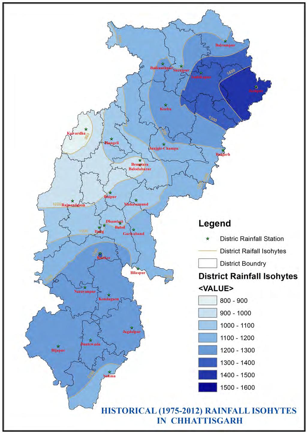
94