Figure 1 Kings Basin
|
|
|
- Berenice Joseph
- 5 years ago
- Views:
Transcription

1 Case Study: Lower Kings Basin Cone of Depression The area covered by the lower Kings Basin includes the lands located in the western portion of the Kings Basin including the small communities of Raisin City, San Joaquin, Tranquillity, and Riverdale. Land use in the lower Kings Basin is primarily agricultural. Groundwater is used to meet all of the urban demands. Groundwater pumping for agricultural use varies as a function of crop water requirements, hydrologic variability, surface water rights, and access to facilities to deliver water. Figure 1 shows the Kings Basin area. Permanent crops, including vineyards and deciduous fruits and nuts, are the dominant crops in the western Kings Basin. Figure 2 denotes land use within the Kings Basin. Figure 1 Kings Basin

2 Figure 2 - Land Use Kings Basin Within portions of the lower Kings Basin, there are no surface water delivery facilities and the area does not have water rights to the Kings or San Joaquin rivers. In those areas, overlying landowners have groundwater rights and are dependent on groundwater to meet 100 percent of crop water demands. Within much of the other portions of the lower Kings Basin, groundwater is used to meet crop water requirements at times when surface water deliveries are not available. The surface water deliveries are derived from water rights and entitlements from the Kings River. Figure 3 shows the Kings River place of use.

3 Figure 3 Kings River Place of Use Map The reliance on groundwater to meet demands is causing the slow depletion of groundwater storage. The depth to groundwater contours for the Kings Basin demonstrate the cone of depression that exists in the lower Kings Basin and surrounding areas. Figure 4 shows the depth to groundwater in Spring Groundwater levels are responsive to flow conditions in the Kings River and the overall hydrology of the basin; however, it is clear that groundwater in the area is pumped at rate greater than that of groundwater recharge.

4 A groundwater trough, or regional water table depression, is a feature of the lower Kings Basin. The total volume of groundwater storage in the lower Kings Basin, though sizable, is not all useable due to both economical and technical reasons that include increased pumping costs due to deepening groundwater levels and excessive lifts; the

5 possibility of causing the migration of poor quality water; and the potential to induce land subsidence. Managing groundwater to meet current and future water needs is a significant challenge in the lower Kings Basin. The stakeholders in that area have recognized that the groundwater basin is one hydrogeologic unit. Groundwater moves from sources of recharge to sources of discharge and/or withdrawal. Based on the evaluation of contour maps, groundwater in this area is primarily recharged from underflow from surrounding areas. The primary regional groundwater flow pattern is from east to west. Consolidated Irrigation District and Fresno Irrigation District are up gradient from and directly abut the lower Kings Basin. Figure 5 shows general flow of groundwater. Figure 5 General Direction of Groundwater Flow It can interpreted from the groundwater level trend lines for the area that groundwater levels will continue to decline into the future should there be no changes in current operations and management. There are several proposed recharge projects to
6 improve groundwater conditions in the area, which are generally favorable for artificial recharge. One proposed project, Raisin City Recharge Pond Project would route available flood flow related water through the Fresno Irrigation District canal system then piped to the Fresno ID/Raisin City WD border and then discharged into a canal. The canal would deliver the water to an 80 acre groundwater recharge basin constructed on land owned by the Raisin City Water District. Figure 6 shows the conceptual design of the project. Figure 6 Another proposed project is the McMullin Recharge Ponds. The proposed project would use flood flows to recharge the groundwater system. The project includes a series of ponds and canals. The project comprises of 205 acres of recharge area. Figure 7 shows the project s recharge basins.
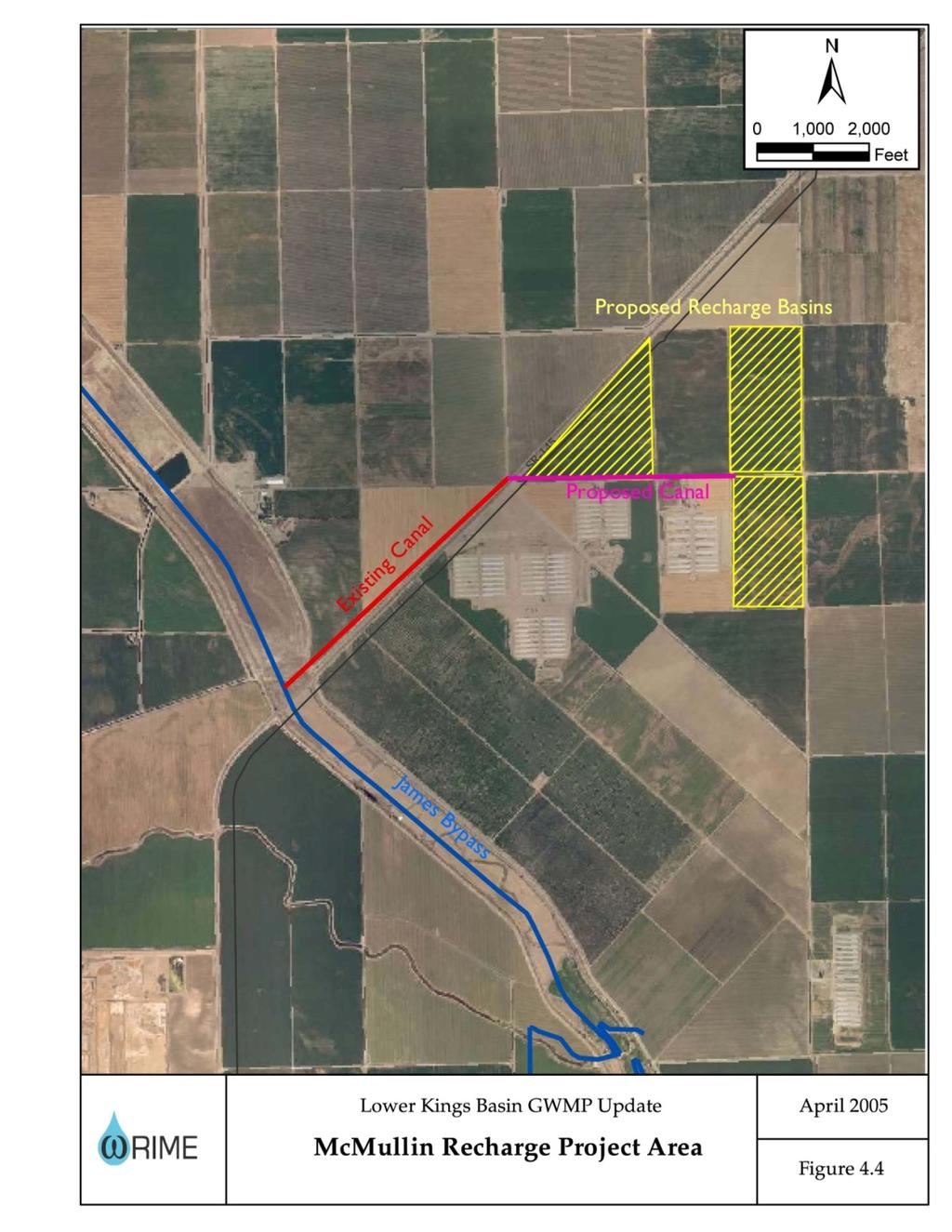
7 Figure 7