Horse Creek Public Hearing February 15, 2017, 2:00 PM
|
|
|
- Marion May
- 5 years ago
- Views:
Transcription
1 Horse Creek Public Hearing February 15, 2017, 2:00 PM Introduction Brief History 2013 Order Results Precipitation Groundwater Diversions Surface Water Diversions Reservoir Stage Horse Creek Streamflow Questions Public Comments / Presentations
2 Horse Creek History Multiple disputes exist including both complaints of well interference with surface water rights and well to well interference complaints A petition to the State Engineer from water users under Hawk Springs Reservoir requested all the wells in this area be regulated in priority to allow Hawk Springs Reservoir to fill. (2/18/09 letter to SEO.) 2011 Hinckley Consulting and AMEC publish Horse Creek Groundwater / Surface Water Connection Investigation, Goshen and Laramie Counties, Wyoming. The study confirmed that surface waters of Horse Creek and the locally-exploited aquifer are so interconnected as to constitute, in fact, one source of supply. The report was reviewed at a public meeting in LaGrange, WY, on November 1, and 2013 Meetings were held between representatives of ground and surface water users in hopes of developing a voluntary operation agreement wherein their needs for water could be met through mutual cooperation. April 12, 2013 The State Engineer held a hearing to determine if groundwater and surface water resources were adequate for the needs of all appropriators.
3 Horse Creek History May 20, 2013 Representatives from Horse Creek Conservation District (HCCD) and groundwater users met with the State Engineer and representatives of the Wyoming Department of Agriculture s Agriculture and Natural Resource Mediation Board. This meeting and attempt at mediation did not result in an agreement. June 18, 2013 A call for regulation was received from HCCD. Hydrographer Gibson honored the call and regulated surface water diversions with inadequate headgates and measuring devices. Hydrographer Gibson also regulated junior irrigation wells in the LaGrange Area. June 28, 2013 Hydrographer Gibson s actions were appealed to Superintendent Pugsley. Superintendent Pugsley overturned Hydrographer Gibson s decision. July 15, 2013 The State Engineer received an appeal of Superintendent Pugsley s decision. July 19, 2013 The State Engineer issued the Horse Creek Basin Order. The Order applies to the LaGrange Aquifer and surface water diversions from Horse Creek at and below the Brown and LaGrange diversion.
4 2013 Horse Creek Order Closed the area to further permitting of large-capacity wells and required the adjudication of unadjudicated large-capacity wells. Limited groundwater well irrigation to 12-inches per acre per year commencing in 2014, and extending for a 3-year period (not to exceed a 36-inch water column). Allowed for a carry over of 6 acre-inches per acre between 3-year periods. Required groundwater wells to have flow meters and to report production annually. Limited surface water diversions to the amount of water which could be applied to the authorized beneficial use(s). Exempted groundwater wells from regulation in correlation with surface water rights.
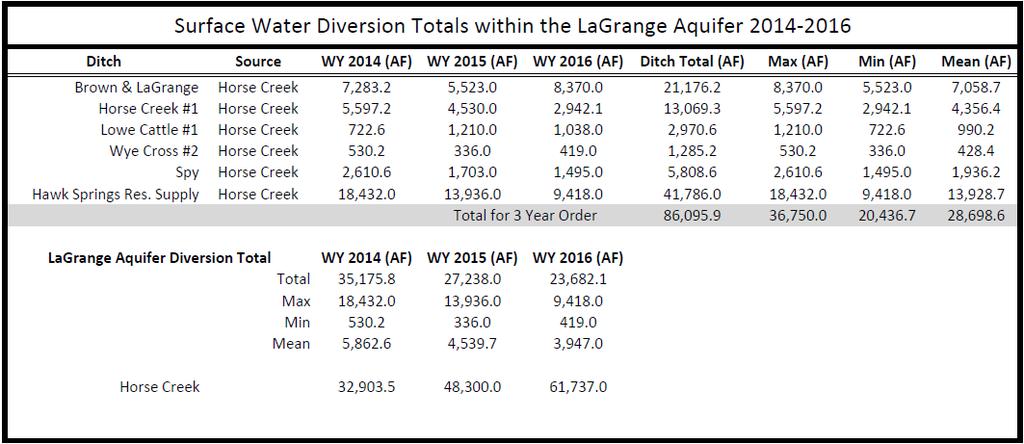
5 2013 Horse Creek Order Required control and accounting devices for Hawk Springs, Springer, Hughes, Little Willow, 66 Pastures, and Bump Sullivan Reservoirs. Required control and flow measuring devices for Horse Creek No. 1, Brown and LaGrange, Lowe Cattle No. 1, Lowe Cattle No. 2, Spy, and Wye Cross ditches. Authorized the Superintendent to order the installation of other devices as necessary. Directed the Superintendent to investigate a streamgage location along Horse Creek near the Brown and LaGrange headgate.
6 2013 Horse Creek Order Results Precipitation Groundwater Production Groundwater Hydrographs Stream Flow Diversions Reservoir Storage
7 30 Yoder Annual Precipitation in Horse Creek Area LaGrange SE (4.5 miles ESE of LaGrange) Philips (17 miles West of LaGrange)
8 Acre-Feet Precipitation (inches) Annual Groundwater Allocation and Production Horse Creek Order 8, ,000 6, ,000 4, Acre-Foot Allocation 3,000 Acre-Feet Produced 2,000 8 Average Precipitation from Philips and Yoder 1, Year 0
9 Acre-Feet 3-Year Allocation vs. Production LaGrange Aquifer 12,000 10,000 Three-Year Acre-Feet Produced Three-Year Acre-Feet Allocated 8,000 6,000 4,000 2, Groundwater Appropriator
10 Percent of Groundwater Allocation Produced LaGrange Aquifer 120.0% 100.0% 80.0% 60.0% % 20.0% 0.0% Groundwater Appropriator
11 3-Year Percent of Groundwater Allocation Produced LaGrange Aquifer 100.0% 90.0% 80.0% 70.0% 60.0% 50.0% 40.0% 30.0% 20.0% 10.0% 0.0% Groundwater Appropriator

12
13 Water Level (Feet Below Ground Surface) LGR1 Well Hydrograph /28/1976 8/28/1984 8/28/1992 8/28/2000 8/28/2008 8/28/2016 Date
14 Water Level (Feet Below Ground Surface) LGR1 Well Hydrograph /14/2013 3/2/2014 9/18/2014 4/6/ /23/2015 5/10/ /26/2016 6/14/2017 Date
15 Water Level (Feet Below Ground Surface) WYard Well Hydrograph /28/1976 8/28/1984 8/28/1992 8/28/2000 8/28/2008 8/28/2016 Date
16 Water Level (Feet Below Ground Surface) WYard Well Hydrograph /14/2013 3/2/2014 9/18/2014 4/6/ /23/2015 5/10/ /26/2016 6/14/2017 Date

17

18 Stream Gage at Goshen Laramie County Line
19 Month and Year Precipitation (inches) Discharge (cubic feet per second) Horse Creek at Laramie / Goshen County Line Compared to Averaged Precipitation
20 CFS Horse Creek at the Goshen/Laramie County Line Daily Mean Discharge (CFS) - Water Year 2014 Instantaneous Peak Flow March 7 th, CFS
21 CFS Horse Creek at the Goshen/Laramie County Line Daily Mean Discharge (CFS) - Water Year 2015 Instantaneous Peak Flow May 26 th, CFS
22 CFS Horse Creek at the Goshen/Laramie County Line Daily Mean Discharge (CFS) - Water Year 2016 Instantaneous Peak 1445 Hrs. May 10 th, CFS
23 CFS Horse Creek at the Goshen/Laramie County Line Daily Mean Discharge (CFS) - Water Year 2017 Instantaneous Peak Flow December 17 th, CFS

24 Brown and LaGrange

25 Brown and LaGrange
26 Cubic Feet per Second 120 Brown and LaGrange Diversion Record and Appropriation Amount Diversion Appropriation /1/13 3/2/14 9/1/14 3/2/15 9/1/15 3/2/16 8/31/16 3/2/17 Date
27 Diversion (Cubic Feet per Second) Horse Creek #1 Diversion Record and Appropriation Amount Diversion Appropriation /1/13 3/2/14 9/1/14 3/2/15 9/1/15 3/2/16 8/31/16 3/2/17 Date
28 Diversion (Cubic Feet per Second) 66 Reservoir Diversion Record Diversion /1/13 3/2/14 9/1/14 3/2/15 9/1/15 3/2/16 8/31/16 3/2/17 Date

29 Lowe Cattle #

30 Lowe Cattle #
31 Diversion (Cubic Feet per Second) Lowe Cattle #1 Diversion Record and Appropriation Amount Diversion Appropriation /01/13 03/02/14 09/01/14 03/02/15 09/01/15 03/02/16 08/31/16 03/02/17 Date
32 Diversion (Cubic Feet per Second) 9 Wye Cross #2 Diversion Record and Appropriation Amount Diversion Appropriation /01/13 03/02/14 09/01/14 03/02/15 09/01/15 03/02/16 08/31/16 03/02/17 Date
33 Diversion (Cubic Feet per Second) Spy Diversion Record and Appropriation Amount Diversion Appropriation /01/13 03/02/14 09/01/14 03/02/15 09/01/15 03/02/16 08/31/16 03/02/17 Date

34 Hawk Springs Inlet

35 Hawk Springs Inlet

36 Hawk Springs Inlet
37 Hawk Springs Reservoir Storage and Capacity Storage (Acre Feet) Storage Adjudicated Capacity Month and Year
38 Hawk Springs Reservoir Total Storage (AF) - Water Year 2014 Peak Capacity 16,747 AF April 8 th, 2014 Adjudicated Capacity 16,735 AF End of Water Year 8,160 AF Carry-over 1,539 AF
39 Hawk Springs Reservoir Total Storage (AF) - Water Year 2015 Peak Capacity 18,390 AF May 29 th, 2015 Adjudicated Capacity 16,735 AF End of Water Year 11,104 AF Carry-over 8,160 AF
40 Hawk Springs Reservoir Total Storage (AF) - Water Year 2016 Adjudicated Capacity 16,735.0 AF Peak Capacity 17,442 AF May 8 th, 2016 Carry-over 11,104 AF End of Water Year 8,450 AF
41 Hawk Springs Reservoir Total Storage (AF) - Water Year 2017 Peak Capacity 16,855 AF January, 17 th, 2017 Adjudicated Capacity 16,735 AF Carry-over 8,450 AF
42
43 Horse Creek Public Hearing February 15, 2017 Questions Public Comments / Presentations