Massachusetts Water Resources Authority Severe Weather Preparedness For MWRA Coastal Facilities
|
|
|
- Corey Chase
- 5 years ago
- Views:
Transcription

1 Massachusetts Water Resources Authority Severe Weather Preparedness For MWRA Coastal Facilities October 16, 2013
2 Water System Not Threatened All MWRA dams, dikes, spillways and appurtenances are inspected routinely by licensed dam safety engineers and are in good condition Since 2006, MWRA has spent over $21 million on dam safety projects Quabbin and Wachusett spillways have been improved to be able to discharge the probable maximum flood (1 in 1000 years) All drinking water pump stations and storage tanks above flooding elevation 2

3 Examples of Dam Improvements: Wachusett Spillway Wachusett Spillway capacity increased by lowering it 2 feet 3

4 Examples of Dam Improvements: Wachusett New Crest Gate Installation of a crest gate greatly enhances discharge operations 4


5 Examples of Dam Improvements: Wachusett Auxiliary Spillway New Wachusett Auxiliary Spillway constructed to pass flood discharge 5

6 MWRA Coastal Facilities MWRA COASTAL FACILITIES 6

7 Sandy Not Like Previous Storms 7


8 Sandy Track 8
 Annual trend 0.01ft/year Annual trend 0.")
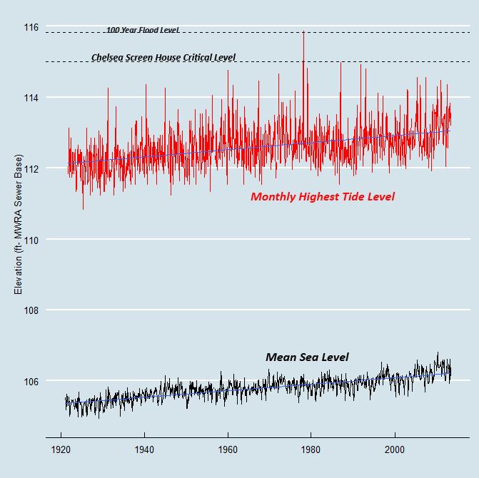
9 Sea-Level Rise Is Already With Us Trend For Boston Inner Harbor, NOAA Tidal Gage # ( ) Annual trend 0.01ft/year Annual trend ft /year Data source : ton%2c+ma&type=historic+tide+data&format=view+data 9
10 Benchmarks For Evaluating Facilities 100 year flood as determined by FEMA (current regulatory requirement) 100 year flood + 2.5ft (NYC DEP, BHA) Additionally Hurricane flooding levels as determined by FEMA s SLOSH model (current evacuation planning recommendation) were reviewed Wave action (for facilities adjacent to FEMA Hazard Zone VE) was reviewed 10


11 How Did Sandy Measure Up? BOSTON NEW YORK NOAA/NOS/CO-OPS Preliminary Water Level(A1:1) vs. Predicted Plot Battery, NY From 2012/10/ /10/30 11

12 How Did Sandy Compare to Historical Storms? 12


13 Hurricane Sandy Impacts On NY/NJ Water Utilities Many water utilities lost power due to lack or loss of generators NYC water was safe to drink, but surrounding counties in NY and NJ had do not use advisories, or boil water notices Passaic Valley was forced to release billions of gallons of raw or partially treated sewage into New York Bay over several weeks 13

14 How Do Facilities Measure Up? 14

15 Facilities Impact Summary 6 Sewer Facilities Likely Affected by a 100 Year Event 9 Sewer and 3 Administration Facilities Likely Affected by a 100 Year feet Event 7 Sewer Facilities Likely Affected by Hurricane Only 5 Sewer Facilities Very Unlikely to be Affected No Water Facility at Risk of Service Disruption 15


16 Chelsea Screenhouse - Vulnerabilities Southwest Facility View Backup Generator 16


17 Braintree-Weymouth Replacement Pump Station - Vulnerabilities Exterior South Side View First Floor Interior South Side View First Floor Switch Gear Room 17

18 Braintree-Weymouth Replacement Pump Station - High Tide 18

19 Chelsea Administration and Maintenance Facilities Flood Inundation 19
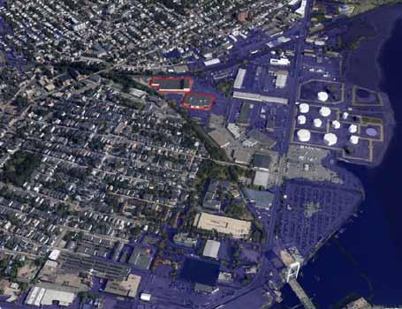


20 Chelsea Administration and Maintenance Facilities FEMA 100 Year Flood Elevation FEMA 100 Year Flood Elevation + 2.5ft 20


21 Past Practice Low-lying facilities are protected with sandbags and pumps Mobile generators are deployed in advance of storms Increased staffing 21

22 Going Forward Short-term At-risk buildings may be fitted with temporary flood barriers Long-term Future rehabilitation contracts will take sea level rise into account Consider moving important equipment to higher elevations 22

23 Alewife Pumping Station: Proposed Modifications 23

24 Created SOPs To Redeploy Staff And Equipment To Higher Ground Staff and equipment redeployed to predetermined locations in advance of storms Back-up water and wastewater operations control center created at Carroll Treatment Plant in Marlborough 24


25 Evaluated Several Flood Barrier Options 25