CMS and Decision Support Discussion Forum: Current and Near-term Satellite Assets
|
|
|
- Jane Wheeler
- 5 years ago
- Views:
Transcription
.")
1 CMS and Decision Support Discussion Forum: Current and Near-term Satellite Assets February 6, 2013 Diane E. Wickland 1 and Marc L. Imhoff NASA HQ, Science Mission Directorate, Earth Science Division 2 - Joint Global Change Research Institute (UMD/PNNL).
2 2

3 Surface Water Ocean Topography > 2020 Ice, Cloud, and Elevation Satellite early 2016 Soil Moisture Active Passive late 2014 Landsat Data Continuity Mission February 2013 Orbiting Carbon Observatory-3 >2016 Orbiting Carbon Observatory- 2 late 2014 Active Sensing of CO2 Emissions over Nights, Days, and Seasons >2021 Pre-Aerosol, Clouds, and ocean Ecosystem >2020 Global Precipitation Measurement Mission February 2014 Stratospheric Aerosol and Gas Experiment-III (ISS) late 2014 Gravity Recovery and Climate Experiment- 3 Follow-on >2017
4 Satellite Measurements of Carbon (1) Land Cover and Terrestrial Ecosystem Properties (systematic global time series) Maps of land cover and vegetation type; quantification of land cover change, disturbance, and regrowth Estimates of vegetation greenness and productivity Detection of active fires, burned area, and fire emissions Ocean Color and Ecosystem Properties (systematic global time series) Estimates of chlorophyll concentration and productivity to infer carbon uptake/export to the deep ocean Estimates of phytoplankton carbon for improved estimates of carbon stocks Estimates of pco 2 for air-sea CO 2 fluxes Other Earth Surface Properties Land surface freeze-thaw status (from microwave sensors) to estimate growing season length (a key control on annual carbon uptake/release) at high latitudes Land surface inundation duration and extent (from microwave sensors) to estimate methane (CH 4 ) fluxes from wetlands 4
5 Satellite Measurements of Carbon (2) Vegetation Canopy Volume, Height, and Vertical Profile Regional/global measurements of vegetation volume scattering to estimate aboveground carbon storage in low biomass vegetation types (Radar) Globally distributed sampling measurements of canopy height and vertical profile to accurately estimate aboveground carbon storage (Lidar) Atmospheric Carbon Dioxide (CO 2 ) Concentration Coarse resolution estimates of CO 2 high in the atmosphere to improve/constrain atmospheric models Accurate and precise estimates of CO 2 in the total atmospheric column, with good sensitivity to CO 2 low in the atmosphere, to locate and quantify surface sources and sinks of carbon 5
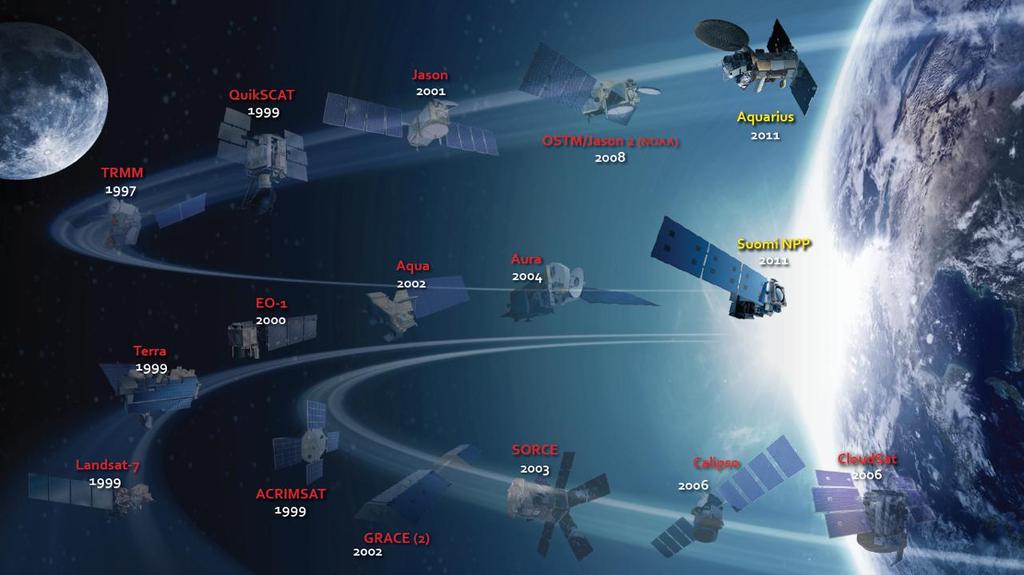
6 NASA S Carbon-Measuring Satellites Satellites Currently in Orbit (some missions recently ended): Aqua Landsat-7 EO-1 Aura Terra QuikSCAT (ended) Terra (MOPPITT - CO) Aqua SeaWiFS (ended) ICESat (ended) Suomi NPP Missions in Formulation and Implementation: OCO-2 LDCM SMAP ICESat-2 Decadal Survey Missions: ASCENDS DESDynI SMAP ICESat-2 SCLP HyspIRI ACE (also PACE) GEO-CAPE LIST Greenhouse Gases Carbon Stocks Supporting Observations 6
7 Non-U.S. Satellites Satellites Currently in Orbit: GOSAT (JAXA) SPOT/VEGETATION (CNES) Resourcesat-2 (India) Oceansat-2 (India) CBERS (China-Brazil Missions in Formulation and Implementation: Sentinel-1 SAR (ESA) Sentinel-2 HR optical (ESA) Sentinel-3 Ocean color (ESA) Missions in Pre-Formulation (early conceptual planning): CarbonSat (ESA) Biomass (ESA) Metop - AVHRR (Eumetsat) ALOS-2 PALSAR (JAXA) SMOS (ESA) GCOM-W - AMSR (JAXA) Metop AVHRR (Eumetsat) GCOM-C (JAXA) Other follow-ons... Many others... Greenhouse Gases Carbon Stocks Supporting Observations 7
8 Transition to NPP / JPSS EDR -- Environmental Data Record (aka. L2) VIIRS Ice Surface Temperature EDR VIIRS Imagery Band (01 to 05) EDR VIIRS Land Surface Temperature EDR VIIRS Near Constant Contrast Imagery EDR VIIRS Net Heat Flux EDR VIIRS Ocean Color/Chlorophyll EDR VIIRS Sea Ice Characterization EDR VIIRS Sea Surface Temperature EDR VIIRS Snow Cover/Depth Binary Map EDR VIIRS Snow Cover/Depth Snow Fraction EDR VIIRS Surface Albedo EDR VIIRS Surface Type EDR VIIRS Suspended Matter EDR VIIRS Vegetation Index EDR VIIRS Day Night Band SDR 8
9 Topics for Discussion How well do we know our current and near-term future EO flight portfolio for carbon science? Missions and Instruments US: NASA and other agencies Non-US: ESA, CNES, JAXA, India, China, others. What would a Strengths, Weaknesses, Opportunities, and Threats (SWOT) analysis look like? Are we generating the appropriate data products from current assets to answer important and emerging questions? Data Models Knowledge Ex: Land cover and land use are not the same. Can we generate use-based products that inform carbon and H20 modeling? Carbon, H2O, and Nitrogen cycles are critically linked. How well are we integrating analyses and creating EO products to inform them? NPP, decomposition, biomass, methane generation etc.. 9