Transit Project Assessment Process
|
|
|
- Jayson James
- 5 years ago
- Views:
Transcription
1 1. INTRODUCTION 1.1 Purpose of the Document On May 17, 2010, the Minister of the Environment for the Province of Ontario issued a Notice to Proceed to the Toronto Transit Commission (TTC) and the City of Toronto for the Eglinton Crosstown Light Rail Transit (ECLRT) Project (the Project), a 33-kilometre electrically-powered Light Rail Transit (LRT) line extending from the Lester B. Pearson International Airport in the City of Mississauga to Kennedy Station in the City of Toronto (see Figure 1-1). The basis for that Notice was the Environmental Project Report prepared in 2010 (2010 EPR) under the (TPAP) found in Ontario Regulation 231/08 (O. Reg. 231/08) to assess potential environmental impacts associated with the project, identify measures to mitigate those impacts, and to develop systems to monitor the progress of implementing those mitigation measures. Subsequently, a Statement of Completion was issued by the TTC and the City that signified the completion of the TPAP. The 2010 EPR was undertaken by the City of Toronto and the TTC as coproponents of the Project. Subsequently, in 2012, Metrolinx assumed management responsibility for the Project and has become the sole proponent for this Addendum. Metrolinx advised the Ministry of the Environment (MOE) of the change in proponents through a letter dated December 13 th, In addition to the change in proponents, Metrolinx has identified the need to revise the Project between Jane Street and Keelesdale Park to: Divide the implementation of the Project into two phases and include a 15- bay bus terminal at the western terminus (Mount Dennis Station) of the first phase; Re-configure the LRT between Jane Street and Keelesdale Park from a surface LRT line in the centre of Eglinton Avenue West to a grade-separated LRT line; and Introduce a Maintenance and Storage Facility (MSF), where light rail vehicles would be maintained and stored, to the Project. These changes to the Project, which are described in more detail in this Addendum, were determined to be inconsistent with the 2010 EPR. As described in Section 15 of Ontario Regulation 231/08, any change that is inconsistent with a previously approved EPR requires a reassessment of the impacts associated with the project, the identification of potentially new mitigation measures, and potentially new monitoring systems in an Addendum to the previously approved EPR. This document serves as an Addendum to the 2010 EPR to address the changes to the ECLRT Project in the Jane Street to Keelesdale Park section (including the bus terminal and MSF). This chapter introduces the changes to the ECLRT Project, the purpose for this Addendum, the process that was followed under the TPAP Regulation and presents the context by describing planning policies that MMM Group October 2013 Page 1-1

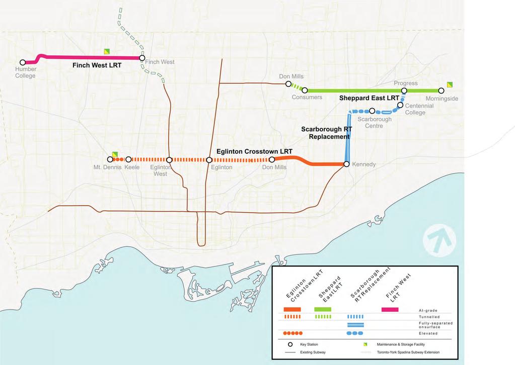
2 applied to this study. Chapter 2 of this report presents feasibility studies and major functional design options considered for the changes to the project. Chapter 3 provides a detailed description of the LRT and MSF within the Addendum study area and presents the preferred alignment design. Chapter 4 updates the existing conditions within the study area since the 2010 EPR. Chapter 5 discusses potential impacts, identifies mitigation measures, and recommends monitoring activities. Chapter 6 outlines the consultation process and activities carried out throughout the planning phase for the Addendum. Chapter 7 presents the commitments of the proponent (Metrolinx) to future action during the design, construction and operational phases. 1.2 Background: The Original Project The Project was one of seven new LRT lines endorsed by the TTC in March 2007 in the Transit City Plan (see Figure 1-1). This plan served as a blueprint to bring higher-order transit service to a broader geographic area within the City of Toronto. The purpose of the Transit City plan is intended to address future transit demands that cannot be met by existing or increased bus service. The plan received the support of the Province of Ontario in June 2007 as part of a strategic transit plan for the Greater Toronto and Hamilton Area, entitled Move Ontario Metrolinx, an agency of the Province of Ontario, approved the new proposed lines as part of their regional transportation plan called The Big Move in December Figure 1-1: Toronto Transit City 2007 Light Rail Transit Plan MMM Group October 2013 Page 1-2
3 Figure 1-1: Toronto Transit City 2007 Light Rail Transit Plan The 2010 EPR identified an alignment for the Project that consisted of LRT technology in the following configuration: On-surface between Pearson International Airport and Keelesdale Park within the centre of Silver Dart Drive, Commerce Boulevard and Eglinton Avenue West (including a new bridge over Highway 401) with passenger access via surface stops; On-surface within the centre of Eglinton Avenue East from east of Brentcliffe Road to Kennedy Station, also with passenger access via surface stops. Underground between Keelesdale Park and Brentcliffe Road due to the narrow right-of-way width of Eglinton Avenue in this section, with passenger access via underground stations with vertical connections to the surface. Between Jane Street and Keelesdale Park, the Project was proposed to be in the centre of Eglinton Avenue West, with surface stops at Weston Road and Black Creek Drive. The 2010 EPR indicated a future connection to an MSF at the former Kodak property, with at-grade access from Eglinton Avenue West. The impacts of the MSF were to be assessed at a later time and were not covered in the 2010 EPR. 1.3 The Changes to the Project In addition to the change of proponents discussed in Section 1.1, this Addendum focuses only on changes to the 2010 EPR proposed in the section between Jane Street and Keelesdale Park. The following is a summary of the components of the proposed configuration of the ECLRT that differ from those recommended in the 2010 EPR: Revised LRT alignment between Jane Street and Keelesdale Park from surface LRT with surface stops as shown in the 2010 EPR to a completely grade-separated LRT alignment with an underground station at Mt. Dennis (see Section 2.1); Revised track alignment connecting the LRT mainline and the proposed Black Creek Maintenance and Storage Facility from an at-grade connection as shown in the 2010 EPR to a grade-separated connection (see Section 2.1); Consolidation of the Weston Stop and the Black Creek Stop (both surface stops shown in the 2010 EPR) into one new underground Mount Dennis LRT Station located at the GO Transit Kitchener Rail corridor; (see Section 2.1); New passenger tunnel connection under the GO Transit Kitchener Rail and Canadian Pacific Railway (CPR) corridors (see Section 2.1); Proposed Black Creek Maintenance and Storage Facility at Mount Dennis (see Section 2.3); and Proposed 15-bay bus terminal and Passenger Pick Up and Drop off at the Mount Dennis LRT station (see Section 2.4). MMM Group October 2013 Page 1-3
4 1.3.1 Study Area The Addendum study area is divided into two major areas along the approved ECLRT alignment where the physical changes are proposed (see Figure 1-2). The study limits for each section are as follows: LRT - West Section: The study area is generally centred on Eglinton Avenue West from Jane Street to Municipal Drive, just east of Keelesdale Park. The Study Area also incorporates the lands for the proposed bus terminal and Passenger Pick Up and Drop Off associated with the Mount Dennis Station. Black Creek Maintenance and Storage Facility (MSF): The study area for the Black Creek MSF includes the former Kodak property north of Eglinton Avenue West to Ray Avenue, generally between the railway corridor to the west and Black Creek Drive to the east. Figure 1-3 illustrates the study area as it relates to the project implementation phasing discussed in Section Updated Project Description Results in Significant Changes In accordance with Section 15 of O. Reg. 231/08, Metrolinx has assessed the significance of the changes to the Project. The changes have been deemed significant for the following reasons: the environmental effects of the MSF were not addressed in the 2010 EPR; the environmental effects of the proposed bus terminal were not addressed in the 2010 EPR; and the change in vertical configuration of the Jane Street to Keelesdale Park section had the potential to affect the former Kodak Building #9; a Provincially-owned heritage building (as described in Section 4.3.2) Studies Prepared in Support of the ECLRT TPAP Addendum The following is a list of studies that were conducted in support of this Addendum report: Stormwater Management and Hydraulic Analysis, see Appendix A; Natural Environment, see Appendix B; Air Quality Assessment, see Appendix C; Noise and Vibration, see Appendix D; Contaminant Overview Study, see Appendix E; Archaeological (Stage 1-2 Archaeological Assessment Report), see Appendix F; Heritage (Cultural Heritage Assessment Report), see Appendix G; and Comparative Traffic Assessment, see Appendix H. MMM Group October 2013 Page 1-4

5 n Ro a MSF Study Area ve Jane Street d i reek Dr to Black C W es ue n ve A y Ra LRT Alignment Study Area t s venue We A n o t n li g E Bicknell Drive i Ra or rid or lc Lambton Avenue OCTOBER 2013 NOT TO SCALE WEST SECTION AND MSF STUDY AREA 1-2
6 n i reek Dr to Black C W es ue n ve A y Ra Ro a Jane Street ve d PHASE 1 t s venue We A n o t n li g E FUTURE PHASE 2 Bicknell Drive i Ra or rid or lc Lambton Avenue OCTOBER 2013 NOT TO SCALE PROJECT IMPLEMENTATION PHASING 1-3
7 1.4 Other Relevant Planning Policies, Studies, and Documents City of Toronto Planning Policies The Toronto Official Plan, 2010 presented a vision for a more livable City that targets growth to specific communities. The areas that have the most potential to accommodate growth and redevelopment are the Downtown and Central Waterfront, the Centres, the Avenues, and Employment Districts. Generally, potential growth areas are well served by transit, the existing road network and existing infrastructure. The Toronto Official Plan recognizes transit corridor expansion along Eglinton Avenue (east of Markham Road extending westerly into Mississauga) including from Weston Road to Kennedy Station. This project will result in improvements to public transit service along Eglinton Avenue over the next decade. The construction of the ECLRT will significantly improve mobility and transportation options for Torontonians, while also bringing a number of planning opportunities and challenges. The City of Toronto, through a funding contribution by Metrolinx, is undertaking the Eglinton Connects Study to develop an urban design vision for the Eglinton Corridor. This comprehensive planning study of the Eglinton Avenue corridor is designed to complement the future ECLRT. The study generally includes the Eglinton Avenue corridor between Jane Street and Kennedy Avenue, and examines where people will live and work and what kind and size of buildings will be along Eglinton Avenue in the future. The study will make decisions about how the streets will function, how they will look and what features/streetscapes they should have. Additional information regarding the Eglinton Connects study is available online at: Province of Ontario Planning Policies The Province began addressing rapid growth in the Toronto region and throughout the province by enacting the Places to Grow Act, 2005 and the Greenbelt Act, These land planning reforms established new frameworks for directing urban growth into designated areas while preserving natural and agricultural landscapes. The desired outcome is a substantial increase in the development density in areas designated for growth. The change in growth from lower density sprawl to higher levels of urban density will place an even greater strain on existing urban infrastructure that already operates at capacity, notably the transportation network. To alleviate the fragmented system of planning, funding, and implementation of the region s urban infrastructure, the Province enacted the Metrolinx Act, The Act created Metrolinx, a regional planning and funding agency for all modes of transportation identified in the region s long-term transportation plan, including the five-year capital investment program, and is responsible for implementation, ownership, and operation of all transportation projects identified in the plan. The Ministry of Transportation Ontario (MTO) and Infrastructure Ontario (IO), a crown corporation, both have critical roles in delivering the provincial urban MMM Group October 2013 Page 1-7
8 growth and transportation investment strategies, and in implementing the Metrolinx program. Specifically, IO leverages Alternative Financing and Procurement (AFP 1 ) in the implementation of transportation projects. MTO is responsible for transportation infrastructure and policy at the provincial level and serves as the conduit for the Province s investment in Metrolinx-funded transportation improvements. In addition, the Ministry of Infrastructure s Ontario Growth Secretariat is also charged with carrying out the provincial land use and growth planning mandates of the Places to Grow Act, 2005 that serves as the basis for integrated transportation and land use planning. Numerous agencies are responsible for the local delivery of transportation, and the frameworks for delivering the multi-modal transportation system remain devolved to local implementation agencies. On June 15, 2007, the Province of Ontario announced $17.5 billion in funding transit projects for the Greater Toronto Area and Hamilton. Named MoveOntario 2020, this 12-year provincial investment strategy to deliver 52 Rapid Transit (RT) projects in the Greater Toronto and Hamilton Area (Figure 1-4) that forms the geographic area in which Metrolinx has the mandate to develop a comprehensive multi-modal transportation network. The Metrolinx Big Five Program was the transit capital investment program originally developed for the first five years of the implementation of the Big Move, the region s long-term transportation plan. The scope of the Big Five Program included four projects within the City of Toronto (City) and one project in the Regional Municipality of York which would be funded through MoveOntario The Metrolinx Regional Transportation Plan (RTP) named The Big Move: Transforming Transportation in the Greater Toronto and Hamilton Area (GTHA) was approved on November 28, The plan identified the ECLRT from Pearson Airport to Scarborough Centre as one of its top priorities for early implementation within the first 15 years (see Figure 1-5). Additional information is available online at: In Spring 2009, the Province announced an investment of $8.15B ($2008) for four LRT projects in Toronto: ECLRT, Scarborough RT conversion/extension, Finch West LRT, and Sheppard East LRT. These four projects were a part of a wider municipal plan known as Transit City (see Figure 1-1), and were identified in the top 15 priority projects in the Metrolinx Big Move plan (see Figure 1-5). In mid-2010, the four projects in Toronto were re-scoped to include a phased implementation approach to meet the capital budget limitations. The portion of the ECLRT west of Jane Station (from Jane Street in Toronto to Pearson Airport 1 From AFP is an innovative way of financing and procuring large, complex public infrastructure projects Under AFP, provincial ministries and / or agencies establish the scope and purpose of the project while the work is financed and carried out by the private sector. Only after a project is completed will the private sector company be repaid by the province AFP allows large, complex infrastructure projects to be delivered faster and more efficiently (at a lower, long-term net cost) than traditional procurement, protects taxpayers from cost overruns, and transfers risks to the partner who has the expertise, experience and ability to handle that risk best. MMM Group October 2013 Page 1-8
9 in Mississauga) was deferred, along with other sections from the other three projects. On April 25, 2012, the Metrolinx Board of Directors voted to move forward with all four Toronto transit projects ECLRT, Scarborough RT conversion/extension, Sheppard East LRT, and Finch West LRT as originally approved by the Metrolinx Board on May 19, 2010, and consistent with the Big Move plan. Figure 1-5 is a map showing the four approved Toronto transit projects. Metrolinx will use IO on all projects, as directed by the Treasury Board, to maximize value and increase certainty of on-time, on budget delivery, subject to the completion of value-for-money analysis on each project. Metrolinx staff were authorized to finalize and execute legal agreements with the City and the Toronto Transit Commission (TTC) relating to the funding and implementation of the projects. This project delivery approach is to be implemented through a newly formed subsidiary corporation of Metrolinx known as the Rapid Transit Implementation (RTI) team. MMM Group October 2013 Page 1-9

10 OCTOBER 2013 NOT TO SCALE THE GREAT TORONTO AND HAMILTON AREA 1-4
11 OCTOBER 2013 NOT TO SCALE METROLINX BIG MOVE - 15 YEAR PLAN 1-5
12
13 Metrolinx has undertaken two studies related to this study. They include: Mount Dennis Mobility Hub In The Big Move, the Regional Transportation Plan for the Greater Toronto and Hamilton Area (GTHA), one priority calls for a system of connected mobility hubs that provides travellers with seamless access to the regional transit system, supports higher density development, and demonstrates excellence in customer service. Mount Dennis was identified as a Mobility Hub in The Big Move. The Mount Dennis Mobility Hub Study being undertaken by Metrolinx is planning for seamless mobility around the station, maximizing connections to transit for the surrounding neighbourhoods, creating an attractive public realm and leveraging transit investment for future investment in the community within an 800 metre radius around the proposed transit station. Mount Dennis has been identified as a Gateway Hub, meaning that it is a major transit station area to be located at the interchange of two or more current/planned regional rapid transit lines (Eglinton LRT and the GO Rail Corridor); and Georgetown South Service Expansion and Union Pearson Express This study includes the service expansion on the Georgetown GO Rail corridor (now known as the Georgetown South Project), and the new Union Pearson Express (UP Express - formerly known as the Union-Pearson Rail Link), runs through the study area along the CPR/GO Transit rail corridor. Studies were conducted to provide infrastructure improvements to meet existing GO Transit ridership demand and future growth expected from the UPExpress. Additional studies and an environmental assessment are being conducted to examine the potential electrification of the rail system (including a potential Traction Power Substation within the study area of this ECLRT EPR Addendum) as a future alternative to diesel trains. Although no GO Rail station currently exists at Mount Dennis, the Georgetown South Service Expansion study protected for its future implementation. The environmental assessment (EA) regarding electrification of the UP Express is following the (TPAP) per O. Reg. 213/08 integrated with the requirements of the Class EA for Minor Transmission Facilities. Recently, GO Transit has renamed the Georgetown South line as the Kitchener line. For additional information regarding the study components and ongoing electrification study please refer to: o Georgetown South Project: o UP Express: o UP Express Electrification Environmental Assessment: TPAP Addendum Process This Addendum is being carried out under Ontario Regulation (O. Reg.) 231/08, the (TPAP). As noted earlier in this Chapter, O. Reg. 231/08, section 15(1) requires an Addendum to the EPR for any changes made to the transit project following the statement of completion that are not considered to be consistent with the EPR referred to in the statement. MMM Group October 2013 Page 1-13
14 The formal public and agency review processes and timelines for finalizing an Addendum to an approved EPR are essentially the same as the TPAP; however, the proponent has discretion regarding the scope of public consultation. Metrolinx undertook a consultation program as described in Section 1.6. The following are the key steps in the TPAP Addendum process: Complete assessment of any impacts the change might have on environment; Complete Addendum report; Prepare and distribute a Notice of ; and Final review by the public and stakeholders prior to proceeding with Project Content of the EPR Addendum Relative to Section 15 of O. Reg 231/08 In accordance with O. Reg. 231/08, Section 15 (1), for all changes to the project inconsistent with the EPR, this Addendum to the ECLRT EPR includes the following information (the location of information in the Addendum appears in bold text): A description of the changes (Chapter 3); Reasons for the changes (Chapter 2); Assessment and evaluation of any impacts that the change may have on the environment (Chapter 5); A description of proposed mitigation measures for any negative impacts that the change to the project may have on the environment (Chapter 5); and A statement of whether the proponent (Metrolinx) is of the opinion that the change is a significant change to the transit project, and the reasons for the opinion (Chapter 3) EPR Addendum Approval Process After completing the Addendum report and filing a Notice of Environmental Project Report Addendum, the report will be made available to the public, regulatory agencies, aboriginal communities or other interested persons for review for a period of 30 days in accordance with the Ontario Regulation 231/08. If objections are received during the 30-day public comment period, the Minister of the Environment has 35 days to consider the objections (if any) regarding negative impacts of the transit project and can act by providing notice to the proponent. Notice from the Minister will state either that the project can proceed, the project can proceed subject to conditions, or that the proponent must conduct additional work prior to proceeding. MMM Group October 2013 Page 1-14
15 1.6 Consultation Program Overview The consultation program for the EPR Addendum study was developed based on the public and stakeholder consultation requirements specified for a TPAP. The following approach was used: Notice of Public Information Centres o To notify all residents about Public Information Centres, and provide information on how to participate/provide comment Prepare Contact/Property Owner Lists o Created and maintained an active contact list to know who needs to be informed of project updates. Develop Website (ECLRT Website: o Updates to the website advertised and summarized information shared at the Public Information Centres. Host Public Information Centres o Advertised by newspaper, website and through mailed notification to names on the contact List. Sign-in sheet for meeting attendees and comment sheet provided input to the project. Manage Comment Tracking/Responses o To manage all comments received during the project, and ensure that all questions from stakeholders and the public are addressed. Notice of o To notify relevant technical stakeholders, the general public, and all residents of the study area about the completion of the project, and provide information on how to access the final report and provide comment. The consultation program is discussed in further detail in Chapter 6 of this EPR Addendum. 1.7 Study Team This study has been undertaken under the direction of Metrolinx. MMM Group was retained by Metrolinx as the prime consultant to undertake the project management and associated technical work. A project team was created with the following sub-consultants to provide specific expertise for the study. Novus Environmental Inc.; Unterman McPhail Associates; and New Directions Archaeology. MMM Group October 2013 Page 1-15
16 This page intentionally left blank. MMM Group October 2013 Page 1-16