12th Annual Louisiana Water Conference March 27-28, 2018
|
|
|
- Irma Rogers
- 5 years ago
- Views:
Transcription

1 12th Annual Louisiana Water Conference March 27-28, 2018
2 Addressing Saltwater Intrusion in the Baton Rouge Area
3 To echo Dr. Groat s comments this morning, let s try a scientific approach and leave emotion out of the equation.
4 Unfortunately, this is how some people view scientists:

5

6 MANAGEMENT AUTHORITY OF THE CAPITAL AREA GROUNDWATER CONSERVATION COMMISSION
7 MANAGEMENT AUTHORITY OF THE CAPITAL AREA GROUNDWATER CONSERVATION COMMISSION
8 East Baton Rouge Parish

9 Saltwater Intrusion Saltwater intrusion is the movement of saline water into freshwater aquifers
10 Contaminant Secondary Standard Aluminum 0.05 to 0.2 mg/l Chloride 250 mg/l Color 15 (color units) Copper 1.0 mg/l Corrosivity noncorrosive Fluoride 2.0 mg/l Foaming Agents 0.5 mg/l Iron 0.3 mg/l Manganese 0.05 mg/l Odor 3 threshold odor number ph Silver 0.10 mg/l Sulfate 250 mg/l Total Dissolved Solids 500 mg/l Zinc 5 mg/l
11 Contaminant Secondary Standard Aluminum 0.05 to 0.2 mg/l Chloride 250 mg/l Color 15 (color units) Copper 1.0 mg/l Corrosivity noncorrosive Fluoride 2.0 mg/l Foaming Agents 0.5 mg/l Iron 0.3 mg/l Manganese 0.05 mg/l Odor 3 threshold odor number ph Silver 0.10 mg/l Sulfate 250 mg/l Total Dissolved Solids 500 mg/l Zinc 5 mg/l
12 EPA National Secondary Drinking Water Regulations are non-enforceable guidelines regulating contaminants that may cause cosmetic effects (such as skin or tooth discoloration) or aesthetic effects (such as taste, odor, or color) in drinking water.

13 Southern Hills Aquifer System Layers subcrop in Mississippi beneath unconsolidated sediments
14 Southern Hills Aquifer System Simplified Cross-Section through Baton Rouge Dip towards the BR Fault to the south Freshwater north of fault Saltwater south of the fault
15 Southern Hills Aquifer System Simplified Cross-Section through Baton Rouge Sands named for their depth in the Industrial District Saltwater is seeping into several sands from the south Two sands are of major importance
16 Saltwater Intrusion/Encroachment Naturally occurring saltwater is moving northward across the Baton Rouge Fault
17 Saltwater Intrusion/Encroachment Naturally occurring saltwater is moving northward across the Baton Rouge Fault
18 Saltwater Intrusion/Encroachment Groundwater withdrawals have caused saltwater to encroach into freshwater-bearing aquifers beneath Baton Rouge Sediment deformation and displacement of sedimentary layers across the fault reduce the hydraulic connections between aquifers, thereby impeding horizontal groundwater flow, which causes substantial changes in both water levels and water quality across the fault.
19 1,500-ft sand
20 USGS 1996 Southern Hills aquifer system USGS 2009 Saltwater intrusion in the 1,500-foot sand


21 USGS 1996 BRWC Wells Southern Hills aquifer system USGS 2009 Saltwater intrusion in the 1,500-foot sand

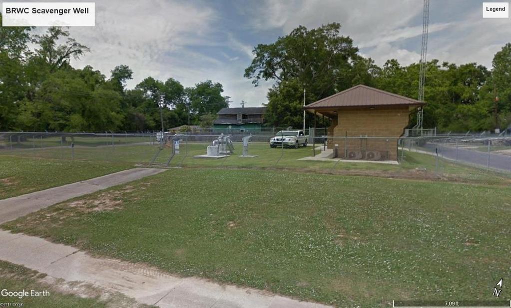
22 BRWC Scavenger Well Baton Rouge Water Company has installed a Scavenger Well between their Lula Street well field and the advancing saltwater plume. Lula Street accounts for 6 MGD of BRWC s total production of 67 MGD, or less than 10% Lula Street wells are located in the 1,500-foot sand
23
24

25
26
27 2,000-ft sand
28 2,000-ft sand What can be done to inhibit saltwater intrusion?
29 USGS Model of current conditions in 2,000-foot sand
30 USGS Model of current conditions in 2,000-foot sand

31 Southern Hills Aquifer System Most Industrial pumping is located in the 2,000- foot sand along the Mississippi River
32 2,000-ft sand Just have industry shut in their wells?
33 Public Supply and Industrial Wells
34 Public Supply and Industrial Wells Approximate area of saltwater leakage across the fault. (1,500 and 2,000 ft sands)
35 USGS Model of current conditions in 2,000-foot sand
36 Projected saltwater intrusion in 2,000-ft sand circa 2050 with no industrial pumping
37 Projected saltwater intrusion in 2,000-ft sand circa 2050 with no industrial pumping Saltwater plume recedes

38 Projected saltwater intrusion in 2,000-ft sand circa 2050 with no industrial pumping But begins migration towards public supply wells
39 2,000-ft sand Just have industry shut in their wells?
40 2,000-ft sand Can we use similar approach as 1,500-ft sand?
41 USGS Model of current conditions in 2,000-sand
42 CAGWCC Planning & Specifications Committee Has met monthly for the past two+ years Investigated possible measures to be taken to slow down salt water intrusion
43 CAGWCC Planning & Specifications Committee Summary Plan for the Management of Salt Water Migration in the 1,500-Foot and 2,000-Foot Sands of the Baton Rouge Aquifer System
44 CAGWCC Planning & Specifications Committee Users will limit production from the 1,500-foot sand to 25 million gallons per day (MGD) averaged over each calendar year in East Baton Rouge Parish. Users of the 1,500-foot sand will install any new well northward away from the Baton Rouge Fault. Additional actions to control saltwater migration will be implemented as computer modeling results are known, if needed.
45 CAGWCC Planning & Specifications Committee Users will limit pumping from the 2,000-foot sand to 24.5 MGD averaged over each calendar year in East Baton Rouge Parish. In the Baton Rouge industrial district users will reduce pumping from the 2,000-foot sand to MGD, a reduction of 2 MGD, by the end of 2014 to further manage salt water migration.
46 CAGWCC Planning & Specifications Committee At the end of 2014 the pumping limit for East Baton Rouge Parish will be 23.5 MGD and the pumping limit for the Baton Rouge industrial district will be MGD. Users of the 2,000-foot sand will install any new well northward away from the Baton Rouge Fault.
47 CAGWCC Planning & Specifications Committee CAGWCC, DOTD, East Baton Rouge Parish (EBR) and the US Geological Survey (USGS) have partnered to produce a computer model depicting and predicting ground water elevations, flow patterns and salt water migration in the 2,000-foot sand. The model will be maintained and updated as new information becomes available.
48 Most likely remediation scenario Saltwater Scavenger Well Similar to BRWC s Would need to be located where sand thickness and chloride concentration would ensure success.

49 USGS Model of current conditions in 2,000-sand
50 Area of Interest
51 So, what next? CAGWCC will review results of Sampling Project. Based upon that review, a decision will be made as to the location for an exploratory well. Similar sampling will be conducted on the third well. If necessary, additional wells will be drilled as funds become available. CAGWCC will investigate a funding source for saltwater scavenger well system. Installation of such a well will not be completed until several years I the future. Until then, CAGWCC shall continue to monitor saltwater encroachment and adjust the 2,000-ft management plan as needed.
52 Acadian Thruway & I-10

53 Acadian Thruway & I-10 EBR Sewage Lift Station

54 Landowner Issues What s in it for me?
55 New Area of Interest
56 New Area of Interest
57 New Area of Interest LDOC
58 New Area of Interest
59 Exploratory Well Commission currently working with Owen & White, LLC to develop a bid package to have the well drilled. Specifics for the well, which will be drilled down to 2,400-ft sand, are still being determined. Many non-scientific considerations, including: Property ownership Well drilling regulations by other agencies Drilling waste disposal
60 Capital Area Ground Water Conservation Commission Questions?