Shakopee, Minnesota St. Paul, Minnesota Citizen Petition
|
|
|
- Clifford Matthews
- 5 years ago
- Views:
Transcription


1
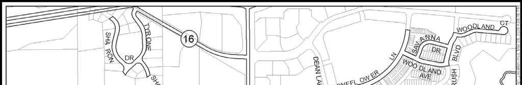
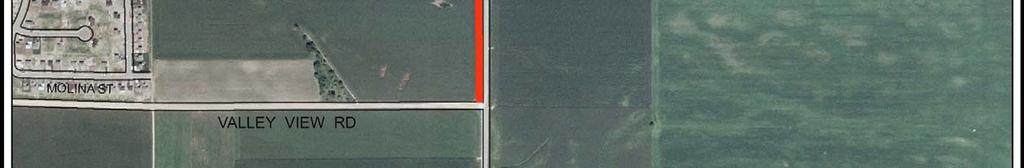
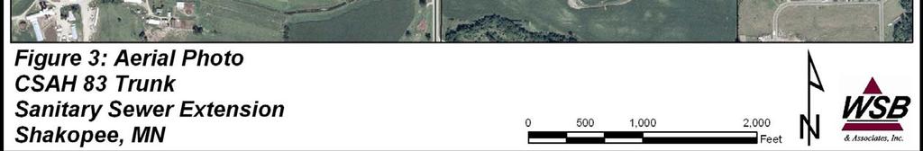
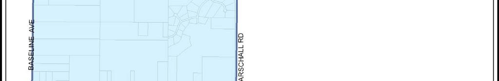
2 ENVIRONMENTAL ASSESSMENT WORKSHEET Note to reviewers: The Environmental Assessment Worksheet (EAW) provides information about a project that may have the potential for significant environmental effects. This EAW was prepared by the Minnesota Pollution Control Agency (MPCA), acting as the Responsible Governmental Unit (RGU), to determine whether an Environmental Impact Statement (EIS) should be prepared. The project proposer supplied reasonably accessible data for, but did not complete the final worksheet. Comments on the EAW must be submitted to the MPCA during the 30-day comment period which begins with notice of the availability of the EAW in the Minnesota Environmental Quality Board (EQB) Monitor. Comments on the EAW should address the accuracy and completeness of information, potential impacts that are reasonably expected to occur that warrant further investigation, and the need for an EIS. A copy of the EAW may be obtained from the MPCA by calling (651) An electronic version of the completed EAW is available at the MPCA Web site 1. Project Title: Shakopee - CSAH 83 Trunk Sanitary Sewer 2. Proposer: City of Shakopee 3. RGU: Minnesota Pollution Control Agency Contact Person Bruce Loney Contact Person William J. Lynott and Title Director of Public Works and Title Project Manager Address City Hall, 129 Holmes Street South Address 520 Lafayette Road North Shakopee, Minnesota St. Paul, Minnesota Phone (952) Phone (651) Fax (952) Fax (651) BLoney@ci.shakopee.mn.us william.lynott@pca.state.mn.us 4. Reason for EAW Preparation: EIS Scoping Mandatory EAW X Citizen Petition RGU Discretion Proposer Volunteered If EAW or EIS is mandatory give EQB rule category subpart number and name: Minn. R , subp. 18.A, Wastewater Systems 5. Project Location: County Scott City Shakopee W 1/2 E ½ Section 16 Township 115N Range 22W Figures: Figure 1 - County map showing the general location of the project; Figure 2 - United States Geological Survey quadrangle map showing the proposed trunk sewer route; Figure 3 - Aerial photograph showing the proposed trunk sewer route and significant project and natural features; Figure 4 Preliminary construction plan; Figure 5 - Potential service area boundary; and Figure 6 Soils Map. TDD (for hearing and speech impaired only): (651) Printed on recycled paper containing 30% fibers from paper recycled by consumers
3 Attachments: Attachment 1 response received from State Historic Preservation Office (SHPO); and Attachment 2 Minnesota Department of Natural Resources (DNR) Natural Heritage Database Search response letter. 6. Description: a. Provide a project summary of 50 words or less to be published in the EQB Monitor. The city of Shakopee (City) is proposing to construct a new trunk sanitary sewer along CSAH 83 to serve future growth areas located to the southwest. The new interceptor is approximately 4,000 feet in length and will provide a flow capacity of up to 2.04 million gallons per day. b. Give a complete description of the proposed project and related new construction. Attach additional sheets as necessary. Emphasize construction, operation methods and features that will cause physical manipulation of the environment or will produce wastes. Include modifications to existing equipment or industrial processes and significant demolition, removal or remodeling of existing structures. Indicate the timing and duration of construction activities. General Project Description The City is proposing to extend a new sanitary sewer trunk toward the south from an existing manhole located at the southwest corner of Church s 1 st Addition (Figure 1). The upstream end of the existing trunk is located on the east side of CSAH 83 (Canterbury Road) and 1,250 feet south of CSAH 16. The existing trunk sewer discharges into the Metropolitan Council Environmental Services (MCES) Chaska Interceptor, which flows to the Blue Lake Wastewater Treatment Plant (WWTP). The proposed interceptor is approximately 4,000 feet in length and will provide a flow capacity of up to 2.04 million gallons per day. The proposed trunk sewer will consist of 18-inch diameter centrifugally cast, fiberglass reinforced, polymer mortar sewer pipe and numerous concrete manholes. Existing Conditions and Land Use The area where the proposed construction will occur is located within existing road right of way. The surrounding land uses include agricultural and open space. The trunk sewer would be constructed within Scott County right of way on an alignment approximately 20 feet west of the east right of way line. It is anticipated that an 80-foot wide temporary easement will be acquired from the adjoining property owners in order to install the pipeline. Construction Methods Construction methods include open cut trench excavation, boring and jacking, pipe and manhole installation, backfilling, and site restoration. The trunk sewer will be constructed at depths varying between 12 and 41 feet. Due to alignment topography, the sewer line will generally be shallower toward the south end and deeper toward the north end. The majority of the pipe will be installed by open cut trench construction methods, with some special trench support (trench boxes, etc.) required in deeper cut sections. Soil material will be excavated and backfilled using hydraulic backhoes, bulldozers, and loaders. Two pipe crossings under existing CSAH 83 will be accomplished by boring or jacking, a total distance of 250 feet. In areas where high ground water levels may be encountered, temporary dewatering will be required to facilitate pipeline installation. Upon completion of the installation work and prior to use, the entire length of sewer line will be leak tested. Shakopee - CSAH 83 Trunk Sanitary Sewer 2 Environmental Assessment Shakopee, Minnesota Worksheet
4 Potential Environmental Effects Due to the nature of the project, the impacts will be temporary and overall environmental effects will be minimal. The proposed pipeline will not cross any significant waterways and there will be no direct impacts to channel beds. Areas within the construction corridor disturbed by the trench excavation activities would be fully restored upon installation of the pipe, matching pre-construction ground contours. The topsoil layer will be excavated, stockpiled, and placed back on the surface of the trench upon completion of the pipe installation and backfilling process. Other than a minor loss of trees at the south end of the project site, no changes to existing land use or cover types is anticipated. Secondary development that would be served by the new trunk sewer would be regulated in accordance with current City zoning and land use requirements. Developers are required to obtain all permits needed to comply with existing regulations to connect to the trunk. When new development is proposed, it may be subject to environmental review depending on the scope of the proposed projects. These projects are reviewed under current City review processes and appropriate mitigation measures will be implemented to address potential environmental effects associated with new projects. Construction Schedule Construction of the proposed sewer trunk is scheduled to begin in June 2006 and be completed by October c. Explain the project purpose; if the project will be carried out by a governmental unit, explain the need for the project and identify its beneficiaries. The purpose of the sewer trunk extension is to provide municipal sanitary sewer service to future growth and development areas of the City in accordance with the City s Comprehensive Land Use Plan. Project beneficiaries include property owners, who will receive improved sanitary sewer service, and the City, which will have improved sewer system capacity, and provide service to accommodate future growth areas identified in the City s Comprehensive Plan. The extension of the trunk sewer will provide some existing residences the opportunity to connect to city sewer, and will avoid construction of septic systems as new development occurs in these areas. It will eliminate the need for a sanitary sewer pumping (lift) station for the River Valley Estates Subdivision (Figure 1), thereby reducing future energy and maintenance needs. A future update of the City s Comprehensive Sewer Plan may conclude that the full capacity of this trunk sewer is not required. Subsequent extensions may, therefore, have reduced capacities. The Blue Lake WWTP has sufficient capacity to handle the flow from this project. d. Are future stages of this development including development on any outlots planned or likely to happen? Yes No If yes, briefly describe future stages, relationship to present project, timeline and plans for environmental review. The trunk sewer is designed to provide trunk sewer connections to serve future growth areas. The area to be served by the new interceptor is shown in Figure 5 and includes approximately 2,580 acres. Individual development projects that may ultimately discharge to the trunk sewer will be responsible for their own environmental review when they are proposed. The review process to evaluate potential environmental impacts and cumulative/secondary impacts resulting from development in the service area is discussed in Item 29. e. Is this project a subsequent stage of an earlier project? Yes No If yes, briefly describe the past development, timeline and any past environmental review. This project further extends a sanitary sewer trunk installed in 2002 (MPCA Permit #36241) and in 2004 Shakopee - CSAH 83 Trunk Sanitary Sewer 3 Environmental Assessment Shakopee, Minnesota Worksheet
5 (MPCA Permit #42675). No environmental review was performed as part of these two previous projects. An Alternative Urban Areawide Review was prepared for the Valley Green Corporate Center, located north of the proposed project site. 7. Project Magnitude Data Total Project Area (acres) 13.9 acres* or Length (miles) 4,000 feet Number of Residential Units: Unattached NA Attached NA maximum units per building NA Commercial/Industrial/Institutional Building Area (gross floor space): total square feet NA Indicate area of specific uses (in square feet): Office NA Manufacturing NA Retail NA Other Industrial NA Warehouse NA Institutional NA Light Industrial NA Agricultural NA Other Commercial (specify) NA Building height NA If over 2 stories, compare to heights of nearby buildings NA *Total project area is estimated based on an average 150-foot wide construction corridor. 8. Permits and Approvals Required. List all known local, state and federal permits, approvals and financial assistance for the project. Include modifications of any existing permits, governmental review of plans, and all direct and indirect forms of public financial assistance including bond guarantees, Tax Increment Financing and infrastructure. Unit of Government Type of Application Status MPCA National Pollutant Discharge To be applied for Elimination System (NPDES) General Stormwater Discharge Permit for Construction Activities MPCA Sewer Extension Permit To be applied for Metropolitan Council Sewer Extension Permit To be applied for concurrence DNR Water Appropriation Permit (may To be applied for if necessary be needed for dewatering) Scott County Utility Permits To be applied for The proposed pipeline alignment does not disturb or abut any wetlands. Coordination with nongovernmental entities will be required as the proposed construction of the sewer is immediately adjacent to the existing private utility mains and overhead power lines. 9. Land Use. Describe current and recent past land use and development on the site and on adjacent lands. Discuss project compatibility with adjacent and nearby land uses. Indicate whether any potential conflicts involve environmental matters. Identify any potential environmental hazards due to past site uses, such as soil contamination or abandoned storage tanks, or proximity to nearby hazardous liquid or gas pipelines. Current land use within the proposed utility corridor consists of agricultural and open space. Low density, single-family residential development is located on the west side of CSAH 83, with higher density residential development at the north and south ends of the project. Shakopee - CSAH 83 Trunk Sanitary Sewer 4 Environmental Assessment Shakopee, Minnesota Worksheet
6 The MPCA s database was searched for potential contaminated sites or environmental hazards located within the general project area. The database includes: properties that have already been investigated and cleaned up; those currently enrolled in cleanup programs; properties that were suspected to be contaminated, but after investigation turned out to be clean; and other sites of interest. One regulated site has been identified and is located about one-quarter mile north of the project area as described: Shakopee Police Firing Range (ID No as referenced in VP9240 and VP9241) This site is located on the east side of CSAH 83 and north of the northern limits of this project. The site is listed in the MPCA database as Inactive under the Voluntary Investigation and Cleanup Program. No other information was readily available regarding this site. The Shakopee Police Firing Range site is located north of the trunk sewer route, and there are no anticipated adverse environmental affects expected. A search of the MPCA s Leaking Aboveground/Underground Storage Tank Sites database was also conducted to identify leaks of petroleum based products from storage tank systems reported to the MPCA. None of the sites are located near the proposed trunk sewer route. Based on the findings above, there is no known potential for significant environmental affects associated with contaminated soil or ground water, abandoned or leaking storage tanks, pipelines, or existing land uses along the interceptor route. 10. Cover Types. Estimate the acreage of the site with each of the following cover types before and after development: Numbers below are based on a typical 150-foot wide construction corridor. Before After Before After Types 1-8 wetlands 0 0 Lawn/landscaping 0 0 Wooded/forest 0 0 Impervious Surfaces Brush/grassland 0 0 Other (river, gravel) 0 0 Cropland TOTAL Other than a very minor potential loss of trees near the south end of project, no changes to existing cover types is anticipated as a result of the project. 11. Fish, Wildlife, and Ecologically Sensitive Resources. a. Identify fish and wildlife resources and habitats on or near the site and describe how they would be affected by the project. Describe any measures to be taken to minimize or avoid impacts. The wildlife in the area is a result of the cover types present. The area contains road and agricultural uses. The project area does not provide significant or rare habitat. Disturbance to the area will be temporary in nature and the area will be restored. b. Are any state-listed (endangered, threatened or special concern) species, rare plant communities or other sensitive ecological resources such as native prairie habitat, colonial waterbird nesting colonies or regionally rare plant communities on or near the site? Yes No If yes, describe the resource and how it would be affected by the project. Indicate if a site survey of the resources has been conducted and describe the results. If the DNR Natural Heritage and Nongame Research program has been contacted give the correspondence reference number. Describe measures to minimize or avoid adverse impacts. Shakopee - CSAH 83 Trunk Sanitary Sewer 5 Environmental Assessment Shakopee, Minnesota Worksheet
7 A review of the Minnesota Natural Heritage Information System database has been requested from the DNR to determine if any rare plant communities or animal species, unique resources, or other significant natural features are known to occur along or near the proposed trunk sewer route. The DNR reports (Attachment 2) that a remnant Maple-Basswood Forest community exists in the area, but the project is not likely to affect it. Information collected in a past EAW in the area (ERDB# ) indicated that there are no known occurrences of rare or endangered species within Section 16 of the project area. While there are known occurrences north of the project limits, no impact on these resources are anticipated as a result of this project. 12. Physical Impacts on Water Resources. Will the project involve the physical or hydrologic alteration (dredging, filling, stream diversion, outfall structure, diking, and impoundment) of any surface waters such as a lake, pond, wetland, stream or drainage ditch? Yes No If yes, identify water resource affected. Describe alternatives considered and proposed mitigation measures to minimize impacts. Give the DNR Protected Waters Inventory (PWI) number(s) if the water resources affected are on the PWI. The pipeline impacts will be temporary with no direct physical or hydrological alteration of any basins. The trench will be backfilled with the same material that is excavated and disturbed areas restored to preexisting conditions. There will be no change in the grades before and after installation. The topsoil layer will be excavated, stockpiled, and placed back on the surface of the trench upon completion of the pipe installation and backfilling process. 13. Water Use. Will the project involve installation or abandonment of any water wells, connection to or changes in any public water supply or appropriation of any ground or surface water (including dewatering)? Yes No If yes, as applicable, give location and purpose of any new wells; public supply affected, changes to be made, and water quantities to be used; the source, duration, quantity and purpose of any appropriations; and unique well numbers and DNR appropriation permit numbers, if known. Identify any existing and new wells on the site map. If there are no wells known on site, explain methodology used to determine. Installation of the sewer trunk may require temporary dewatering to keep the trench excavations dry. This may involve the installation of temporary dewatering wells, well points, or dewatering sumps along the interceptor trench. The DNR regulates water appropriation and necessary permits for dewatering will be obtained by the appropriate party when required. Discharge of clean water from dewatering activities will be directed away from the trench to stabilized vegetated areas, rivers/wetlands, drainage ditches, or existing storm sewer systems. A well search was completed for the project area and about five wells were found within one-quarter mile of the proposed trunk sewer alignment. A majority of wells in the vicinity were screened to take water from depths significantly greater than the proposed sewer invert, so impacts to existing wells are not anticipated. Even should temporary dewatering be needed to facilitate pipeline installation, it is expected to have a minimal impact on ground water levels outside the project construction zone. If impacts to nearby wells occur during dewatering activities, temporary water service will be provided. 14. Water-Related Land Use Management Districts. Does any part of the project involve a shoreland zoning district, a delineated 100-year flood plain, or a state or federally designated wild or scenic river land use district? Yes No If yes, identify the district and discuss project compatibility with district land use restrictions. Shakopee - CSAH 83 Trunk Sanitary Sewer 6 Environmental Assessment Shakopee, Minnesota Worksheet
8 15. Water Surface Use. Will the project change the number or type of watercraft on any water body? Yes No If yes, indicate the current and projected watercraft usage and discuss any potential overcrowding or conflicts with other uses. 16. Erosion and Sedimentation. Give the acreage to be graded or excavated and the cubic yards of soil to be moved: 13.8* acres; 168,000 cubic yards. Describe any steep slopes or highly erodible soils And identify them on the site map. Describe any erosion and sedimentation control measures to be used during and after project construction. *Due to jacking/boring of pipe in select locations, the area to be graded/excavated is less than the 13.9-acre total provided in Item 7. An average depth of pipe was assumed to be 25 feet for the volumetric calculation. There are no steep slopes and only limited areas of highly erodible soils along the pipeline route. Since construction of the interceptor will disturb more than one acre of land, a permit application for coverage under Minnesota NPDES General Stormwater Discharge Permit MN R for Construction Activities is required and will be submitted to the MPCA prior to construction. The permit application certifies that temporary and permanent erosion and sediment control plans have been prepared and implemented to prevent soil particles from being transported off site. Temporary erosion and sediment control measures, such as silt fence, sediment filters and traps, erosion control matting, mulching, and crushed rock pads, will be used where applicable. Soils tracked from the construction site by motor vehicles and construction equipment will be cleaned from paved roadway surfaces throughout the duration of the construction project. All disturbed areas will be restored to original contours and seeded and mulched as soon as practical after the pipe installation work has been completed. Temporary erosion and sediment control measures will be maintained during construction and will remain in place until all disturbed areas have been stabilized and vegetation has been re-established. 17. Water Quality Surface-water Runoff. a. Compare the quantity and quality of site runoff before and after the project. Describe permanent controls to manage or treat runoff. Describe any stormwater pollution prevention plans. Construction of the sewer trunk will create temporary land disturbance, and, as discussed under Item 16, best management practices for construction erosion control in conformance with the MPCA NPDES General Construction Stormwater Permit will be used to mitigate potential water quality impacts. For the long term, however, construction of the underground sewer itself will not affect the quantity or quality of stormwater runoff since vegetative cover will be restored and no new impervious surfaces will be created. Secondary runoff related impacts created by development served by the interceptor are discussed under Item 29. b. Identify routes and receiving water bodies for runoff from the site; include major downstream water bodies as well as the immediate receiving waters. Estimate impact runoff on the quality of receiving waters. Stormwater runoff from the project area is directed to the roadside ditches. A portion of the water drains to the north along CSAH 83 and a portion is directed to the south. The portion that is directed to the south remains in the ditch and infiltrates near the culvert under CSAH 83. The portion of the Shakopee - CSAH 83 Trunk Sanitary Sewer 7 Environmental Assessment Shakopee, Minnesota Worksheet
9 site that is directed north drains to the K-Mart linear ponds along TH 169 and eventually to Blue Lake and the Minnesota River. Since the project will not change the runoff characteristics, and with the implementation of temporary erosion and sediment control measures, construction of the trunk sewer will have no impact on the overall water quality of receiving waters. 18. Water Quality - Wastewater. a. Describe sources, composition and quantities of all sanitary, municipal and industrial wastewater produced or treated at the site. The sanitary sewer trunk is a conduit to convey wastewater to the MCES Chaska Interceptor. It will convey wastewater from residential, commercial and industrial areas based on potential service areas (see Figure 5). b. Describe waste treatment methods or pollution prevention efforts and give estimates of composition after treatment. Identify receiving waters, including major downstream water bodies, and estimate the discharge impact on the quality of receiving waters. If the project involves on-site sewage systems, discuss the suitability of site conditions for such systems. Not applicable. c. If wastes will be discharged into a publicly owned treatment facility, identify the facility, describe any pretreatment provisions and discuss the facility s ability to handle the volume and composition of wastes, identifying any improvements necessary. The proposed sewer trunk does not directly discharge into any publicly-owned treatment facility. Downstream sanitary effluent eventually reaches the MCES Blue Lake WWTP. As the City and the surrounding area grows, flows to the MCES interceptors will increase, and the total inflow to the WWTP will increase. Eventually, inflows will reach the treatment plant capacity and the treatment plant will need to be upgraded and expanded again. d. If the project requires disposal of liquid animal manure, describe disposal technique and location and discuss capacity to handle the volume and composition of manure. Identify any improvements necessary. Describe any required setbacks for land disposal systems. Not applicable. 19. Geologic Hazards and Soil Conditions. a. Approximate depth (in feet) to Ground water: ~10 feet minimum; ~20-30 feet average. Bedrock: 75 feet minimum; 81 feet average. Describe any of the following geologic site hazards to ground water and also identify them on the site map: sinkholes, shallow limestone formations or karst conditions. Describe measures to avoid or minimize environmental problems due to any of these hazards. Ground water depth is expected to vary seasonally. There are no known sinkholes, shallow limestone formations, karst conditions, or other potential geologic hazards along the proposed interceptor route that could potentially impact ground water. Pipe joints and manhole connections will be sealed appropriately for sanitary sewer construction to prevent infiltration/exfiltration. Upon completion of the trunk sewer installation work and prior to use, the entire length of sewer line will be leak tested. Shakopee - CSAH 83 Trunk Sanitary Sewer 8 Environmental Assessment Shakopee, Minnesota Worksheet
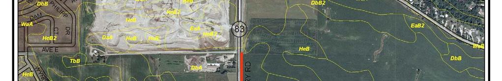
10 b. Describe the soils on the site, giving SCS classifications, if known. Discuss soil granularity and potential for ground water contamination from wastes or chemicals spread or spilled onto the soils. Discuss any mitigation measures to prevent such contamination. As shown on the Scott County soils database, the specific soil types present along the sewer trunk route include the following: o o o o o o o Dickman sandy loam, 0 to 2 percent slopes (DbA) Estherville loam and sandy loam, 0 to 2 percent slopes (EeA) Estherville loam and sandy loam, 2 to 6 percent slopes (EeB) Sparta loamy fine sand, 0 to 2 percent slopes (HeA) Sparta loamy fine sand, 2 to 6 percent slopes (HeB) Sparta loamy fine sand, 6 to 12 percent slopes (HeC2) Waukegan silt loam, 0 to 2 percent slopes (WaA) The soils within the site include both Group A and Group B hydrologic soils, are excessively or well drained, and have rapid to moderately rapid permeability. Due to the nature of the project and the short time the trench will be open, the potential for ground water contamination during construction is low. Any spills of controlled substances will be cleaned up quickly and thoroughly to protect soil and ground water resources. Based on the county soil data, hydric soils are not present within the project area. 20. Solid Wastes, Hazardous Wastes, Storage Tanks. a. Describe types, amounts and compositions of solid or hazardous wastes, including solid animal manure, sludge and ash, produced during construction and operation. Identify method and location of disposal. For projects generating municipal solid waste, indicate if there is a source separation plan; describe how the project will be modified for recycling. If hazardous waste is generated, indicate if there is a hazardous waste minimization plan and routine hazardous waste reduction assessments. Construction and operation of the sewer pipeline will not generate solid or hazardous waste, except for minor amounts of solid waste in the form of construction debris. Construction specifications will require construction contractors to properly dispose of construction debris at a permitted facility in accordance with Minnesota Solid Waste Rules. b. Identify any toxic or hazardous materials to be used or present at the site and identify measures to be used to prevent them from contaminating ground water. If the use of toxic or hazardous materials will lead to a regulated waste, discharge or emission, discuss any alternatives considered to minimize or eliminate the waste, discharge or emission. No toxic or hazardous materials will be used during construction other than gasoline, diesel fuel, and hydraulic fluid used in vehicles and construction equipment. Fuel will be brought in to the equipment by tanker truck approximately once per day during construction. Construction documents will contain provisions for the use and storage of fuel during construction. In particular, construction documents will identify staging and refueling areas. Any spills that might occur will be cleaned up immediately in accordance with regulatory requirements. Shakopee - CSAH 83 Trunk Sanitary Sewer 9 Environmental Assessment Shakopee, Minnesota Worksheet
11 c. Indicate the number, location, size and use of any above or below ground tanks to store petroleum products or other materials, except water. Describe any emergency response containment plans. Construction of the proposed sewer pipeline will not involve the installation of any above or below-ground storage tanks. 21. Traffic. Parking spaces added: 0 Existing spaces (if project involves expansion): 0 Estimated total average daily traffic generated: 0 Estimated maximum peak hour traffic generated (if known) and its timing: 0 Provide an estimate of the impact on traffic congestion affected roads and describe any traffic improvements necessary. If the project is within the Twin Cities metropolitan area, discuss its impact on the regional transportation system. The project does not involve any traffic improvements or permanent increases in traffic. Varying numbers of vehicles will be involved in excavation and construction activities. Impacts on traffic will be minor, site specific, and short term. The pipe will be jacked under CSAH 83, thus avoiding temporary closure and traffic rerouting at these roadway crossings. Necessary and appropriate traffic warning devices will be used during construction. 22. Vehicle-Related Air Emissions. Estimate the effect of the project s traffic generation on air quality, including carbon monoxide levels. Discuss the effect of traffic improvements or other mitigation measures on air quality impacts. Note: If the project involves 500 or more parking spaces, consult EAW Guidelines about whether a detailed air quality analysis is needed. Vehicle emissions associated with the pipeline construction and operation will not have a significant effect on air quality. During construction, varying numbers of vehicles will be involved in excavation and construction activities. These vehicles will have only short-term, negligible impacts on local air emissions. 23. Stationary Source Air Emissions. Describe the type, sources, quantities and compositions of any emissions from stationary sources of air emissions such as boilers, exhaust stacks or fugitive dust sources. Include any hazardous air pollutants (consult EAW Guidelines for a listing), any greenhouse gases (such as carbon dioxide, methane, and nitrous oxides), and ozone-depleting chemicals (chlorofluorocarbons, hydrofluorocarbons, perfluorocarbons or sulfur hexafluoride). Also describe any proposed pollution prevention techniques and proposed air pollution control devices. Describe the impacts on air quality. Not applicable. 24. Odors, Noise and Dust. Will the project generate odors, noise or dust during construction or during operation? Yes No If yes, describe sources, characteristics, duration, quantities or intensity and any proposed measures to mitigate adverse impacts. Also identify locations of nearby sensitive receptors and estimate impacts on them. Discuss potential impacts on human health or quality of life. (Note: fugitive dust generated by operations may be discussed at item 23 instead of here.) Odors Odors are not expected to be a problem during or after the sewer trunk construction. There may be some short-term, fugitive wastewater odors in the general vicinity of locations where new sewer line connections are made. Shakopee - CSAH 83 Trunk Sanitary Sewer 10 Environmental Assessment Shakopee, Minnesota Worksheet
12 Noise Construction vehicles and equipment will generate noise during construction of the interceptor; however, no significant impact is anticipated because of the low density of housing along the interceptor alignment, the limited number of vehicles involved in construction, and adherence to normal construction hours (Monday through Saturday). Noise impacts will be temporary and will be generally confined to the immediate vicinity of the project area. Dust Construction activities will generate localized dust from earth moving/excavation equipment. Due to the low density of housing immediately surrounding the alignment, the dust associated with construction activities is not expected to be a problem. Dust generated during construction will be minimized using dust control measures such as watering. Seeding and mulching disturbed areas will effectively control dust at the end of construction. 25. Nearby Resources. Are any of the following resources on or in proximity to the site? a. Archaeological, historical, or architectural resources? Yes No b. Prime or unique farmlands or land within an agricultural preserve? Yes No c. Designated parks, recreation areas, or trails? Yes No d. Scenic views and vistas? Yes No e. Other unique resources? Yes No If yes, describe the resource and identify any project-related impacts on the resources. Describe any measures to minimize or avoid adverse impacts. Information was requested from the SHPO about possible archeological, historical, or architectural resources located along or near the proposed trunk sewer route. An response dated March 10, 2006 (see Attachment 1), indicated that SHPO s database review identified no archaeological sites or historic structures. 26. Visual Impacts. Will the project create adverse visual impacts during construction or operation? Such as glare from intense lights, lights visible in wilderness areas and large visible plumes from cooling towers or exhaust stacks? Yes No If yes, explain. 27. Compatibility With Plans and Land Use Regulations. Is the project subject to an adopted local comprehensive plan, land use plan or regulation, or other applicable land use, water, or resource management plan of a local, regional, state or federal agency? Yes No If yes, describe the plan, discuss its compatibility with the project and explain how any conflicts will be resolved. If no, explain. Growth areas to be served by the proposed sewer trunk are identified in the Comprehensive Sewer Plan (See Figure 5). The new sewer trunk is not only compatible with the plan, but is an integral part of the plan to accommodate future growth. 28. Impact on Infrastructure and Public Services. Will new or expanded utilities, roads, other infrastructure or public services be required to serve the project? Yes No If yes, describe the new or additional infrastructure or services needed. (Note: any infrastructure that is a connected action with respect to the project must be assessed in the EAW; see EAW Guidelines for details.) Shakopee - CSAH 83 Trunk Sanitary Sewer 11 Environmental Assessment Shakopee, Minnesota Worksheet
13 Although construction will not require additional infrastructure, future development planned for the sewer service area will. As development occurs, new and expanded infrastructure and public services, such as roadways, streets, sanitary sewers, future wastewater plant expansions, water lines, drainage systems, power lines, gas lines, schools, police and fire protection, and other related urban services, will be required. 29. Cumulative Impacts. Minn. R , subp. 7, item B requires that the RGU consider the cumulative potential effects of related or anticipated future projects when determining the need for an environmental impact statement. Identify any past, present or reasonably foreseeable future projects that may interact with the project described in this EAW in such a way as to cause cumulative impacts. Describe the nature of the cumulative impacts and summarize any other available information relevant to determining whether there is potential for significant environmental effects due to cumulative impacts (or discuss each cumulative impact under appropriate item(s) elsewhere on this form). Construction of the proposed sewer trunk enables future residential, commercial, and industrial development. This development could create secondary impacts to wetlands, stormwater runoff and receiving waters, wildlife, and traffic. Some of these projects will be subject to environmental review depending on the scope of the project(s). These will be reviewed at the time of the proposals, and planned mitigation measures, if necessary, identified. In addition to the environmental review process, new development will be required to obtain permits and approvals that will help control potential impacts. These include: the NPDES General Permit to Discharge Stormwater from Construction Sites, Wetland Conservation Act Permitting, and approvals according to City ordinances. These ordinances include provisions for preliminary and final plats, stormwater management and erosion and sediment control, tree preservation standards, wetlands protection, grading and drainage, and street improvements. Applicable policies from this City Code include: City Code Chapter 11, Section 11.01, Subdivision 2 This Chapter is enacted to promote the public health, safety, and general welfare of the City of Shakopee through the following: A. encouraging the planned and orderly development of residential, business, industrial, recreational and public land; B. providing adequate light, air and convenience of access to property; C. limiting congestion in the public right of way; D. preventing overcrowding of land and undue concentration of population and structures; E. providing for the compatible integration of land uses and the most appropriate use of land; F. encouraging development in accordance with the City's comprehensive plan; G. conserving the natural beauty and environmental assets of the City; H. protecting water resources and water quality; I. facilitating the provision of water, utilities and sewage disposal to property as appropriate; J. protecting the population from fire and other hazards to public safety; and K. providing for the administration of this Chapter and amendments to it, defining the powers and duties imposed by this Chapter and prescribing penalties for violation of its provisions. While development is expected, ordinances and regulatory requirements are in place to plan for and mitigate potential secondary impacts. Shakopee - CSAH 83 Trunk Sanitary Sewer 12 Environmental Assessment Shakopee, Minnesota Worksheet
14
15


16


17
18


19


20
21
22
23
24
25