CRUISE REPORT. SSV Robert C. Seamans
|
|
|
- Polly West
- 5 years ago
- Views:
Transcription
1 CRUISE REPORT S241 SCIENTIFIC ACTIVITIES Honolulu HI Honolulu HI 11 May 8 June, 2012 SSV Robert C. Seamans Sea Education Association Woods Hole, Massachusetts 1
2 TABLE OF CONTENTS Data Availability 2 Data Description 3 Figure 1. Cruise track of S41 3 Figure 2. Surface Temperature S Figure 3. Surface Salinity S Figure 4. ADCP Measurements of Magnitude and Direction of the Surface Current. 5 Figure 5. East component of S241 ADCP-Measured Velocity: Equator to Hawaii. 5 Figure 6. Temperature Salinity Cross Section from Hawaii to the Equator. 6 Figure 7. Salinity Cross Section from Hawaii to the Equator. 6 Figure 8. Density Cross Section from the Equator to Hawaii. 7 Figure 9. Oxygen Concentration and Oxygen Saturation from the Equator to Hawaii. 7 Figure 10. S241 In situ Chlorophyll a Fluorescence Cross Section, from Hawaii to the Equator and back. 8 Figure 11. Surface Temperature and Salinity from 0 to Hawaii. 8 Table 1. S41 Midnight and Noon Positions 9 Table 2. Ship s Complement for SSV Robert C. Seamans Cruise S Table 3. Student Projects Aboard S Data and Sampling Appendices A. S41 Scientific Station Summary 11 B. S41 Surface Stations 13 C. S41 Hydrocast Data 14 D. S41 and Secchi Disc Station Summary 15 E S41 Station Profiles 16 F. S41 Net Collections 29 G. S241 Sediment Collections 29 Page This document should be cited as: Lea, Charles E., Final report for S.E.A. cruise S241. Sea Education Association, Woods Hole, MA To obtain unpublished data, contact the Chief Scientist or SEA data archivist: Data Archivist Sea Education Association P.O. Box 6 Woods Hole, MA Phone: Fax: data-archives@sea.edu Web: 2
 was a passage from Honolulu Hawaii to the Palmyra Atoll and the equator before returning to Honolulu.")

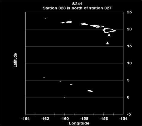
3 Data Description This cruise report provides a record of data collected aboard the SSV Robert C. Seamans during Cruise S41. The cruise track of S41 (Figure 1, Table 1) was a passage from Honolulu Hawaii to the Palmyra Atoll and the equator before returning to Honolulu. Aspects of the central North Pacific as recorded on S41 including: currents, temperature, salinity, oxygen, and chlorophyll are displayed in Figures The cruise participants are listed in Table 2. Student projects aboard S41 are listed in Table 3. During the four week voyage we collected samples or data at 31 discrete oceanographic stations (Appendix A), and 25 surface stations (Appendix B). Chemical properties of seawater with depth are contained in Appendix C. The information is listed in Appendix D and the profiles are illustrated in Appendix E. Summaries of biological net samples are contained in Appendix F. Summaries of sediment collections are listed in Appendix G. Figure 1. Cruise track of SSV Robert C Seamans cruise S241, 11 May 8 Jun, Noon and midnight positions are indicated. 3

4 Figure 2. Surface Temperature S241. Figure 3. Surface Salinity S241. 4


5 Figure 4. ADCP Measurements of Magnitude and Direction of the Surface Current. Figure 5.East component of S241 ADCP-Measured Velocity: Equator to Hawaii. 5

6 Figure 6. Temperature Cross Section from Hawaii to the Equator. Figure 7. Salinity Cross Section from Hawaii to the Equator. 6

7 Figure 8. Density Cross Section from the Equator to Hawaii 7


8 Figure 11. Surface Temperature and Salinity Plot from 0 to Hawaii. 8
9 TABLE 1. S241 Noon and Midnight Positions. DATE TIME LAT. LONG. COMMENTS 2011 (local) ( N) ( W) 11-May ' N ' W Alongside, Pier 36 Honolulu HI 12-May ' N ' W Alongside, Pier 36 Honolulu HI ' N ' W Alongside, Pier 36 Honolulu HI 13-May ' N ' W Alongside, Pier 36 Honolulu HI ' N ' W 14-May ' N ' W ' N ' W 15-May ' N ' W ' N ' W 16-May ' N ' W ' N ' W 17-May ' N ' W ' N ' W 18-May ' N ' W ' N ' W 19-May ' N ' W ' N ' W 20-May ' N ' W ' N ' W 21-May ' N ' W ' N ' W 22-May ' N ' W Anchored Palmyra Lagoon ' N ' W Anchored Palmyra Lagoon 23-May ' N ' W Anchored Palmyra Lagoon ' N ' W Anchored Palmyra Lagoon 24-May ' N ' W Anchored Palmyra Lagoon ' N ' W 25-May ' N ' W ' N ' W 26-May ' N ' W ' N ' W 27-May ' N ' W ' N ' W 28-May ' N ' W ' N ' W 29-May ' N ' W ' N ' W 30-May ' N ' W ' N ' W 31-May ' N ' W ' N ' W 1-Jun ' N ' W ' N ' W 2-Jun ' N ' W ' N ' W 3-Jun ' N ' W ' N ' W 4-Jun ' N ' W ' N ' W 5-Jun ' N ' W ' N ' W 9
10 6-Jun ' N ' W ' N ' W 7-Jun ' N ' W ' N ' W 8-Jun ' N ' W ' N ' W Alongside, Pier 36 Honolulu HI Table 2. Ship s Complement for SSV Robert C. Seamans Cruise S241 Nautical Staff Pamela Coughlin Caroline Smith Saphrona Stetsom Heidi Miller Dusty Smith Preston Luce Sayzie Koldys Lauren Hill Scientific Staff Chuck Lea Randy Jones Julia Twitchell Tom Wootton Captain Chief Mate 2 nd Mate 3 rd Mate Engineer Asst Engineer Steward Asst Steward Chief Scientist First Assistant Scientist Second Assistant Scientist Third Assistant Scientist Deck Hands Marina Cassio Erin Cobb Chelsea Gray Hannah Holland Katie Richwine Shiloh Schlung Adrienne Wilbur Wei Xin Students Jaymes Awbrey Emily Busam Quinn Christie Jacob Harris Lilly Pearson Katherine Pollock Delphinia Remaniak Malcolm Sackler Emily Steingart Wouter Zwart Carleton College Lawrence University University of North Carolina,Wilmington University of Rhode Island Carleton College Evergreen State College College of the Atlantic Evergreen State College Northwestern University Dartmouth College 10
11 Table 3. Student Projects Aboard S241. The Effects of El Niño Southern Oscillation (ENSO) Cycle on Equatorial Currents in the Pacific Ocean Documenting Variations in Surface and Deep Chlorophyll in Pacific Central Gyre, Tropical Divergence and Equatorial Water The Distribution of Neustonic Myctophids in the Central Pacific Water Masses in the Equatorial Pacific During La Nina Months Pteropod Distribution in the Northern Equatorial Pacific Halobates Species Distribution across Oceanic Ecosystems in the Tropical Central Pacific: The Effect of Oceanic Currents on Pelagic H. micans and H. sericeus Range Boundaries Wouter Zwart Emily Steingart, Emily Busam, Kate Pollock Malcolm Sackler, Quinn Christie Delphinia Remaniak Lillian Pearson, Jaymes Awbrey Jacob Harris APPENDIX A STATION INFORMATION SUMMARY OF S241 STATION DATE TIME LAT. LONG. GENERAL LOCALE EQUIPMEN T Surface Sta (LOCAL) ( N) ( W) # May ' N ' W Central Gyre Neuston Net May ' N ' W Central Gyre Phyto net 006 Secchi Disc Neuston Net May ' N ' W Central Gyre (Cross Seamount) Shipek Grab May ' N ' W Central Gyre Neuston Net May-12 09xx ' N ' W Central Gyre Phyto net 008/#13 Secchi Disc Niskin Bottles Neuston Net May ' N ' W Central Gyre Meter net Neuston Net May ' N ' W Central Gyre Phyto net 010 Secchi Disc Neuston Net May ' N ' W Central Gyre Meter net 011 Neuston Net May ' N ' W N. Equatorial Current Area Phyto net 012 Secchi Disc Neuston Net May ' N ' W N. Equatorial Current Area Neuston Net May ' N ' W N. Equatorial Current Area Phyto net 014 Secchi Disc 11
12 Neuston Net May ' N ' W N. Equatorial Current Area Neuston Net May ' N ' W Tropical Divergence 016 Meter net Neuston Net May ' N ' W Tropical Divergence Phyto net 017/#13 Secchi Disc Niskin Bottles Neuston Net May ' N ' W Tropical Divergence Neuston Net May ' N ' W Trop. Div./Equatorial Area Phyto net May ' N ' W Equatorial Area Phyto net Secchi Disc Neuston Net May ' N ' W Equatorial Area Neuston Net May ' N ' W Equatorial Area Phyto net Secchi Disc Neuston Net May ' N ' W Equatorial Area Meter net Neuston Net May ' N ' W Equatorial Phyto net Secchi Disc Niskin Bottles Neuston Net May ' N ' W Equatorial Area Secchi Disc Neuston Net May ' N ' W Equatorial Area Secchi Disc May ' N ' W Equatorial Area Secchi Disc Jun ' N ' W Tropical Divergence Secchi Disc Jun ' N ' W N. Equatorial Current Area Secchi Disc Jun ' N ' W N. Equatorial Current Area Secchi Disc Jun ' N ' W Central Gyre Secchi Disc Jun ' N ' W Central Gyre Neuston Net Jun ' N ' W Central Gyre Secchi Disc Jun ' N ' W Central Gyre Secchi Disc 12
13 APPENDIX B SURFACE STATION INFORMATION S241 Statio n SS- Date Time Log Lat. Long. Temp. Sal. NO 3 PO 4 CDOM Flour Chlor. a in vivo Chlor. a (local ) (nm) N W ( C) (PSU) (µm) (µg/l) (V) (µg/l) #/l May ' ' May ' ' May ' ' May ' ' May ' ' May ' ' May ' ' May ' ' May ' ' May ' ' May ' ' May ' ' May ' ' May ' ' May ' ' May ' ' May ' ' May ' ' May ' ' May ' ' May ' ' May ' ' May ' ' May ' ' May ' ' Microplastic 13
14 APPENDIX C S241 HYDROCAST DATA. Dash (-) indicates no value. Station locations are given in Appendix A. STATION BOT. DEPTH TEMP. SAL. DENSITY O 2 O 2 PO 4 NO 3 CHLOR. CHLOR. PAR (m) ( C) (PSU) (kg/m3) Probe Winkler (μg/l) (μm) (μg/l) (V) S241 # (ml/l) (ml/l) Central Gyre May ' N x ' W Secchi depth:32; 1%= PAR 1% depth= DCM=145m DCM=145m (Chlor V@145m) STATION BOT. DEPTH TEMP. SAL. DENSITY O 2 O 2 PO 4 NO 3 CHLOR. CHLOR. PAR (m) ( C) (PSU) (kg/m3) Probe Winkler (μg/l) (μm) (μg/l) (V) S241 # (ml/l) (ml/l) Tropical Divergence May ' N x ' W Secchi depth:23; 1%= PAR 1% depth= DCM=60M (Chlor V@60M) STATION BOT. DEPTH TEMP. SAL. DENSITY O 2 O 2 PO 4 NO 3 CHLOR. CHLOR. PAR (m) ( C) (PSU) (kg/m3) Probe Winkler (μg/l) (μm) (μg/l) (V) S241 # (ml/l) (ml/l) Equator ' N x ' W Secchi depth:23; 1%= PAR 1% depth= DCM=35m (Chlor V@35m)
15 APPENDIX D S241 AND SECCHI DISC STATION SUMMARY STATION DATE LAT. LONG. CAST DEPTH GENERAL LOCATION Secchi Depth SD 1% Depth S ( N) ( W) (m) (m) (m) May ' N ' W 1031 Central Gyre May ' N ' W 1040 Central Gyre May ' N ' W 1135 Central Gyre May ' N ' W 1045 North Equatorial Current Area May ' N ' W 1103 North Equatorial Current Area May ' N ' W 1109 Tropical Divergence May ' N ' W 1030 Tropical Divergence May ' N ' W 1009 Equatorial Area May ' N ' W 1044 Equatorial Area May ' N ' W 940 Equatorial Area May ' N ' W 1125 Equatorial Area May ' N ' W 1055 Equatorial Area May ' N ' W 733 Equatorial Area May ' N ' W 947 Equatorial Area Jun ' N ' W 1005 Tropical Divergence Jun ' N ' W 1029 North Equatorial Current Area Jun ' N ' W 1112 North Equatorial Current Area Jun ' N ' W 1050 Central Gyre Jun ' N ' W 1756 Central Gyre Jun ' N ' W 1032 Central Gyre - Hawaiin Islands


16 APPENDIX E. S241 STATION PROFILES N N 16


17 APPENDIX E. S241 STATION PROFILES N 17


18 APPENDIX E. S241 STATION PROFILES N N 18


19 013 9 N 19


20 APPENDIX E. S241 STATION PROFILES N N 20


21 APPENDIX E. S241 STATION PROFILES N 21


22 019 2 N APPENDIX E. S241 STATION PROFILES Equator 22


23 022 2 N 23


24 APPENDIX E. S241 STATION PROFILES N N 24


25 APPENDIX E. S241 STATION PROFILES N N 25


26 APPENDIX E. S241 STATION PROFILES N N 26


27 APPENDIX E. S241 STATION PROFILES N N 27


28 APPENDIX E. S241 STATION PROFILES Composite of all S241 Profiles S S S S S S S S S S S S S S S S S S S S
 ( N) ( W) ( C) (PSU) (v) (m) (ml) (ml/m2) (Pieces) (Pellets) (pieces) 001 13-May-12 2338 41.7 20 22.9' N 157 49.2' W Central Gyre 24.9 34.")


29 APPENDIX F. S241 NET COLLECTIONS NEUSTON DATA SUMMARY STATION DATE TIME LOG LAT. LONG. GENERAL LOCALE SURF.TEMP. SURF.SAL. SURF. CHLORa TOW DIST. ZOOP.VOL ZOOP.BIOMASS PLASTIC TAR HALOBATES moon phaserisen or set (nm) ( N) ( W) ( C) (PSU) (v) (m) (ml) (ml/m2) (Pieces) (Pellets) (pieces) May ' N ' W Central Gyre set May ' N ' W Central Gyre risen May ' N ' W Central Gyre set May ' N ' W Central Gyre risen May ' N ' W Central Gyre set May ' N ' W Central Gyre risen May ' N ' W Central Gyre set May ' N ' W North Equatorial Current Area risen May ' N ' W North Equatorial Current Area set May ' N ' W North Equatorial Current Area risen May ' N ' W North Equatorial Current Area set May ' N ' W Tropical Divergence set May ' N ' W Tropical Divergence risen May ' N ' W Tropical Divergence set May ' N ' W Equatorial Area risen May ' N ' W Equatorial Area set May ' N ' W Equatorial Area risen May ' N ' W Equatorial Area risen May ' N ' W Equatorial Area set Jun ' N ' W Central Gyre risen PHYTOPLANKTON NET COLLECTIONS STATION DATE TIME LAT. LONG. DEPTH GENERAL LOCALE TEMP. SAL. SURF. CHLa % Diatoms % Dinoflagellates S (Local) ( N) ( W) (m) ( C) (PSU) (V) May ' N ' W 0-5 Central Gyre May ' N ' W 0-5 Central Gyre May ' N ' W 0-5 Central Gyre May ' N ' W 0-5 North Equatorial Current Area May ' N ' W 0-5 North Equatorial Current Area May ' N ' W 0-5 Tropical Divergence May ' N ' W 0-5 Equatorial Area May ' N ' W 0-5 Equatorial Area May ' N ' W 0-5 Equatorial Area May ' N ' W 0-5 Equatorial Area METER NET AND 2-METER NET COLLECTIONS STATION DATE TIME LOG LAT. LONG. GENERAL LOCALE NET TYPE TOW TYPE MESH SIZE DEPTH TOW VOL. ZOOPLANK. VOL.ZOOPLANK. DENSIT S (local) (NM) ( N) ( W) (μ) (m) (m 3 ) (ml) (ml/100m 3 ) May ' N ' W Central Gyre 1m Stepped oblique May ' N ' W Tropical Divergence 1m Stepped oblique Sample lost May ' N ' W Equatorial Area 1m Stepped oblique APPENDIX G. S241 SEDIMENT COLLECTIONS SHIPEK GRAB STATIONS STATION DATE TIME LOG LAT. LONG. GENERAL LOCALE DEPTH COMMENTS S241 (local) (NM) ( N) ( W) (m) May ' N ' W Cross Seamount >300m Carbonate sediments, half foraminiferous. 29