|
|
|
- Benjamin Wood
- 5 years ago
- Views:
Transcription
1 LSA
2
3
4
5
6
7
8
9
10
11
12
13
14
15
16
17
18
19
20 FUTURE LAND USE MAP (FLUM) AMENDMENT For 9600 Nine Mile Road Proposed Subdivision Parcel IDs: 01-1S & (APO) 01-1S Pensacola, Florida Prepared by: May 2014 GULF CIVIL ENGINEERING, LLC Site/Civil Design Services Certified DBE, WBE & EDWOSB Firm FL Certificate of Auth # Bayview Way Pensacola, FL Prepared for: Olson Land Partners, LLC 4300 Legendary Drive, Suite 234 Destin, FL GCE Project No
21 TABLE OF CONTENTS 1. Introduction General Property Information Compatibility Analysis Public Facilities Impacts Sanitary Sewer Solid Waste Disposal Potable Water Stormwater Management Traffic Recreation and Open Space Schools Environmental, Historical and Archeological Impacts Consistency with Comprehensive Plan...5 SUPPLEMENTAL DOCUMENTS A. Project Location and Future Land Use Map B. Emerald Coast Utilities Authority (ECUA) Water and Sewer Availability Letter C. Preliminary Traffic Concurrency Analysis (Source: Escambia County) D. Escambia County Schools Level of Service Determination (Source: Escambia County School District) E. Wetland Maps (Source: Bosso-Imhof Environmental Sciences, Inc.) F. Historical & Archeological Data (Source: Florida Master Site File)
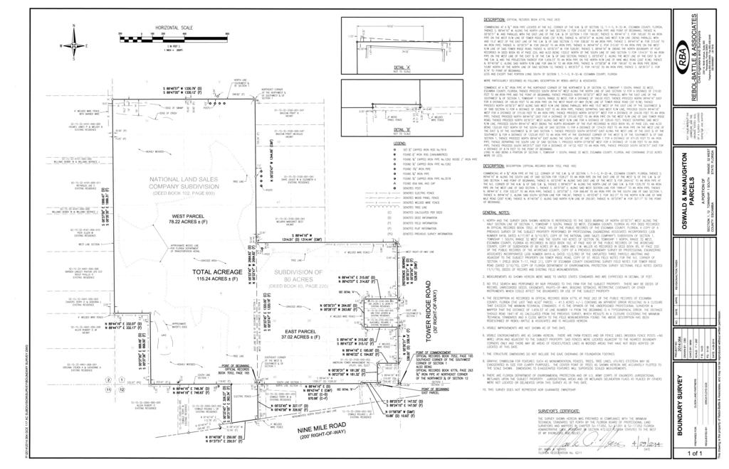
22 1. Introduction This report provides a written request for a Future Land Use Map (FLUM) Amendment of Parcel Number 01-1S and a portion of (APO) Parcel Number 01-1S in Pensacola, Florida. The existing FLUM designation for the property is Rural Community (RC). The desired FLUM Classification is Mixed-Use Suburban (MU-S). 2. General Property Information PROPERTY ADDRESS: PARCEL ID #: INTENDED PROPERTY USE: PROPERTY OWNER: AUTHORIZED AGENT: LEGAL DESCRIPTION: PROOF OF OWNERSHIP: CURRENT ZONING: PROPOSED ZONING: CURRENT FLU: PROPOSED FLU: 9600 W. Nine Mile Road 01-1S & A portion of (APO) 01-1S Residential Subdivision Olson Land Partners, LLC (see enclosed Contract for Sale ) 4300 Legendary Drive, Suite 234 Destin, FL Erica Floyd, P.E. Gulf Civil Engineering, LLC 2940 Bayview Way Pensacola, FL See enclosed Boundary Survey See enclosed Tax Ownership Documents Residential: 1-family and 2-family district, Medium Density (R-3) Residential: 1-family and 2-family district, Medium Density (R-3) Rural Community (RC) Mixed-Use Suburban (MU-S) The property is located at 9600 W. Nine Mile Road in central Escambia County at the intersection of Nine Mile Road and Mobile Highway. The site is approximately two (2) miles west of Beulah Road. The combined parcels include approximately 115 acres of property along the north side of Nine Mile Road. Maps of the existing property are included in the Supplemental Documents section of this report. The requested FLUM Amendment to MU-S would allow for development of up to ten (10) dwelling units per acre for the site; however the developer is anticipating construction of approximately 275 residential units which calculates to 2.4 dwelling units per acre (275 units 115 acres). Page 1 of 9
23 3. Compatibility Analysis The property is currently designated Rural Community (RC). The desired FLUM Category is Mixed-Use Single Family Residential (MU-S). Existing properties adjacent to the subject property have the following FLUM designations: Current FLUM Designations of Surrounding Properties: North: Rural Community (RC) South: Rural Community (RC) East: Mixed-Use Suburban (MU-S) West: Rural Community (RC) Maps of the above listed properties and their designations is included in the Supplemental Documents section of this report. The maps show the limits of the Rural Community (RC) and Mixed-Use Suburban (MU-S) FLUM categories. Outside of the adjacent properties, the surrounding areas to the east are predominantly designated as MU-S. Based on the surrounding property information, the proposed land use amendment is considered compatible with adjacent land uses. 4. Public Facilities Impacts The desired Zoning and Future Land Use Map changes have been analyzed to determine what impacts the maximum development conditions would have to the various public facilities and infrastructure that currently exists and serves the site. As mentioned, the requested FLUM Amendment to MU-S would allow for development of up to ten (10) dwelling units per acre for the site; however the developer is anticipating construction of a maximum 275 residential units. The following analysis compares impacts to public facilities for current conditions and future conditions (years 2015 & 2025) based on the maximum density calculated (180 dwelling units): 4.1 Sanitary Sewer The property is located within the Emerald Coast Utilities Authority (ECUA) service area for sanitary sewer collection. Although an existing ECUA collection system is not readily available to the site, connection to the sanitary sewer system can be achieved. An existing ECUA 8 sanitary force main is located approximately 1.5 miles east of the property near Allegheny Avenue (Keystone Subdivision). Construction of an on-site sanitary lift station and connection to the existing force main would be proposed if designed, permitted and approved by ECUA. The estimated sanitary sewer demand for the maximum development conditions of 275 dwelling units is approximately 86,625 gallons per day (90 gallons per capita day x 3.5 persons per unit x 275 units). The Emerald Coast Utilities Authority has indicated that Page 2 of 9
24 they have the capacity to service the developed property. A copy of the ECUA water and sewer availability letter in included in the Supplemental Documents section of this report. According to the information listed above, it is determined that ECUA has the necessary capacity to provide sanitary sewer collection service to the developed site. However, any proposed development at the subject property would require the proper review and approval from ECUA prior to service connection. 4.2 Solid Waste Disposal Solid waste collection service for development of the subject property shall be provided by the Emerald Coast Utilities Authority. Disposal of solid waste in the region is routed to the Perdido Landfill in Cantonment, Florida. The landfill is operated by the Escambia County Department of Waste Management. Projected solid waste for the proposed development can be estimated at 5,775 pounds per day (6ppc/day x 275 units x 3.5 persons per unit). This value is estimated for a 275 dwelling units and, according to ECUA and Escambia County officials, is within the population projections for the landfill. Any future development of the site will not adversely affect the County landfill Level of Service (LOS). 4.3 Potable Water The property is located within the Emerald Coast Utilities Authority (ECUA) service area for potable water distribution. An existing ECUA water service main (8 ) is located along the north side of Nine Mile Road. Connection to this water service line would be proposed if designed, permitted and approved by ECUA. The estimated potable water demand for the maximum development conditions of 275 dwelling units is approximately 96,250 gallons per day (100 gallons per capita day x 3.5 persons per unit x 180 units). The Emerald Coast Utilities Authority has indicated that they have the capacity to service the developed property. A copy of the ECUA water and sewer availability letter in included in the Supplemental Documents section of this report. According to the information listed above, it is determined that ECUA has the necessary capacity to provide potable water service to the developed site. However, any proposed development at the subject property would require the proper review and approval from ECUA prior to service connection. 4.4 Stormwater Management Stormwater management systems shall be designed, permitted and approved by all necessary regulatory agencies prior to development of the subject property. These agencies include (at a minimum) Escambia County, the Florida Department of Environmental Protection and the Northwest Florida Water Management District. Current regulations require the site to obtain permitting through the State of Florida s Page 3 of 9
25 Environmental Resource Permitting (ERP) program with design criteria that includes water quality and flood control devices which meet the current County and State requirements. The property owner shall obtain all necessary State and County permits for development prior to performing any proposed improvements to the site. 4.5 Traffic The subject property includes approximately 250 feet of frontage along Nine Mile Road (State Road 10). Access to the site shall be provided with a proposed connection to Nine Mile Road. Preliminary discussions with the Florida Department of Transportation (FDOT) determined that future development shall require a deceleration lane and possible leftdirectional median cut at the site. Further review and analysis shall be required for permitting of the future connection to Nine Mile Road and/or any other roadway access connection proposed for the property. Additional analysis and design shall be required to meet the Level of Service standards of the current roadway segments. All roadway improvements shall be permitted through FDOT and Escambia County prior to development. An Initial Test for Traffic Concurrency, provided from the Escambia County Traffic Division, shows that the roadway segment meets the test for concurrency. A copy of this worksheet is included in the Supplemental Documents portion of this report. 4.6 Recreation and Open Space Escambia County provides the community with a number of parks, recreation facilities and open spaces. The proposed FLUM amendment shall not exceed the capacity for such facilities however use of the existing County recreational facilities will be enjoyed by the residents of the proposed development. Numerous parks and recreational facilities are located along State Road 10A (Mobile Highway) south of the proposed development. 4.7 Schools The requested Future Land Use Map amendment would allow for a greater density of the existing property. The proposed development desires 275 dwelling units which would generate a potential impact to Escambia County schools, however discussions with School Board officials revealed that schools within the County currently have the capacity for the proposed density. According to the Escambia County School District, the proposed project meets the level of service requirements of the Florida Statutes. A copy of the School District s Level of Service Determination letter is in included in the Supplemental Documents section of this report. 5. Environmental, Historical and Archeological Impacts Environmental impacts to the existing property shall be minimal. The subject property size totals roughly 115 acres. No known wellheads are located near the property. Conversations with Page 4 of 9
26 officials from both Escambia County and ECUA confirmed that no wellheads are in the project vicinity. According to officials, the closest known wellhead is over five (5) miles east of the property. The majority of the site is currently used as grazing land. The western and northwestern portions of the site are heavily wooded and include significantly sized wetland areas. These wetland areas have been identified and delineated totaling approximately 18 acres. Protection of these areas will be ensured in the design and permitting of the proposed development. A map of the delineated wetland areas is included in the Supplemental Documents portion of this report. A preliminary investigation of the site shows no current signs of threatened or endangered species present on the property. The existing land cover on the western and northwestern portions of the property consists of wetland vegetation, magnolias, pines and brush. Any protected trees or vegetation shall be identified prior to development. The State of Florida Division of Historical Resources was contacted regarding the subject property. A preliminary historic and archeological investigation revealed no significant buildings, bridges, sensitive areas or other items of historical significance on or near the property. The discovery of such items is highly unlikely in the region. A copy of the correspondence received from the Florida Master Site File is included in the Supplemental Documents portion of this report. 6. Consistency with Comprehensive Plan The following discussion demonstrates that the proposed Future Land Use Map amendment is consistent with the adopted Escambia County Comprehensive Plan (2030). Applicable sections from the Comprehensive Plan have been included with responses following each section. OBJ CMS 1.3 Standards: Establish concurrency management system requirements and LOS standards. Policy CMS 1.3.1: Consistency with Comprehensive Plan - No development activity may be approved unless it is found that the development is consistent with the Escambia County Comprehensive Plan and that the provision of the facilities enumerated in CMS will be available at prescribed LOS concurrent with the impact of the development on those facilities. RESPONSE: The applicant understands the approval of the FLUM Amendment shall require all future development of the subject property be designed to meet all Escambia County Planning, Zoning and Development Review requirements. Issuance of a Development Order or Subdivision/Site Plan Approval shall be contingent upon the design meeting the current Land Development Code standards and the provisions set forth in CMS Allocation of Capacity. Policy CMS 1.3.2: Minimum Requirements - At a minimum, the Concurrency Management System shall ensure that at least one of the following standards will be met prior to issuance of a development permit or order: Page 5 of 9
27 a. The necessary facilities and services are in place at the time a development permit is issued; or b. A development permit is issued subject to the condition that the necessary facilities and services will be in place and available to serve the new development at the time of the issuance of a certificate of occupancy; or c. The necessary facilities are under construction at the time a permit is issued. This provision only relates to parks and recreation facilities and roads; or d. The necessary facilities and services are the subject of a binding executed contract for the construction of the facilities or the provision of services at the time the development permit is issued. This provision only relates to parks and recreation facilities. The LDC will include a requirement that the provision or construction of the facility or service must commence within one year of the issuance of the development order or permit; or e. The necessary facilities and services are guaranteed in an enforceable development agreement. An enforceable development agreement may include, but is not limited to, development agreements pursuant to Section , Florida Statutes, or an agreement or development order issued pursuant to Chapter 380, Florida Statutes. For transportation facilities, all in-kind improvements detailed in a proportionate fair share agreement must be completed in compliance with the requirements of the LDC. For potable water, wastewater, solid waste, stormwater and public school facilities, any such agreement will guarantee the necessary facilities and services to be in place and available to serve the new development at the time of the issuance of a certificate of occupancy; or f. The necessary facilities needed to serve new developments are included in the first three years of the applicable Five-Year Florida Department of Transportation (FDOT) Work Program or in place or under actual construction no more than three years after the issuance, by the County, of a development order or permit. This provision only relates to roads. The Five-Year FDOT Work Program is attached herein to this ordinance as Exhibit A. g. The necessary concurrency standards for public school facilities shall be consistent with Chapter 16, Public School Facilities Element. RESPONSE: The proposed development is well within the service areas of the County and Utility infrastructure and will not negatively impact or degrade the level of service. In addition, the applicant understands the development must meet County standards concurrent with the CMS requirements. OBJ FLU 1.5: Sustainable and Energy Efficient Development - Escambia County shall promote sustainable and energy efficient development by encouraging compact, mixedand multi-use land use patterns. Policy FLU 1.5.4: Compact Development and Maximum Densities and Intensities - To ensure developments are designed to be compact and to accommodate travel mode choice, especially for short, local trips, the County will require minimum densities in the Mixed-Use-Suburban Future Land Use category and encourage the maximum densities and intensities in the Mixed Use-Urban Future Land Use category. Page 6 of 9
28 RESPONSE: The Future Land Use Change request for the property is Mixed-Use Suburban (MU-S). Most of the properties to the east (outside of those immediately adjacent to the property) are also designated MU-S; therefore, compact development is continuing to be promoted in this region. The requested density for the development is over two (2) units per acre thus meeting the minimum density requirement for MU-S. Chapter 10: Infrastructure Element - The purpose of the Infrastructure Element is to provide guidance in the provision of services necessary to accommodate existing and future development in a way that is environmentally sensitive, efficient, and cost-effective. Included within this Element are goals, objectives and policies regarding potable water provision, wastewater treatment, solid waste disposal, stormwater management and aquifer protection. The adequate provision of these services is intended to promote orderly growth within areas best suited to accommodate development, protect sensitive natural resource systems and rural and agricultural areas, and preserve the public health, safety, and general welfare of Escambia County s citizens. RESPONSE: The subject parcel is located in central Escambia County. As proven in the body of this report, the proposed FLUM amendment for the subject parcel meets the goals, objectives and policies regarding potable water, wastewater, solid waste, stormwater management and aquifer protection. OBJ CON 1.3: Surface Water Resources - Protect and improve the quality, biological health, and natural function of all surface water systems to preserve their ecological and aesthetic values. CON 1.3.1: Stormwater Management - Escambia County shall protect surface water quality by implementing the stormwater management policies of the Infrastructure Element to improve existing stormwater management systems and ensure the provision of stormwater management facilities concurrent with the demand for such facilities. RESPONSE: Stormwater management facilities shall be designed, permitted and approved by all necessary regulatory agencies prior to development of the subject property. These agencies include (at a minimum) Escambia County, the Florida Department of Environmental Protection and the Northwest Florida Water Management District. The property owner shall obtain all necessary State and County permits for development prior to performing any proposed improvements to the site. CON 1.3.7: Wetland Development Provisions - Development in wetlands shall not be allowed unless sufficient uplands do not exist to avoid a taking. In this case, development in wetlands shall be restricted to allow residential density use at a maximum of one unit per five acres or to the density established by the future land use map containing the parcel, whichever is more restrictive, or one unit per lot of record if less than five acres in size. (For this policy, lots of record do not include contiguous multiple lots under single ownership.) a. With the exception of water-dependent uses, commercial and industrial land uses will not be located in wetlands that have a high degree of hydrological or biological significance, including the following types of wetlands: Page 7 of 9
29 1. Wetlands that are contiguous to Class II or Outstanding Florida Waters; 2. Wetlands located in the FEMA Special Flood Hazard Areas; 3. Wetlands that have a high degree of biodiversity (three or more focal species) or habitat value based on maps prepared by the Florida Fish and Wildlife Conservation Commission or Florida Natural Areas Inventory (see attached maps adopted as part of the comprehensive plan), unless a site survey demonstrates that there are no listed plant or animal species on the site. The Escambia County Biodiversity Hot Spots Map and the Escambia County Critical Habitat Map are attached to this Ordinance as Exhibits O and P, respectively. RESPONSE: The wetland areas on the subject property have been identified and delineated. Protection of these areas will be ensured in the design and permitting of the proposed development. A map of the delineated wetland areas is included in the Supplemental Documents portion of this report. CON 1.3.8: Density Clustering - Escambia County shall require buffers between development and environmentally sensitive areas including wetlands. The purpose of the buffer is to protect natural resources from the activities and impacts of development. a. The buffer shall function to provide protection to the natural resources from intrusive activities and negative impacts of development such as trespass, pets, visual impacts, vehicles, noise, lights, and stormwater. Incompatibility between the uses shall be minimized or eliminated so that the land uses can co-exist over time with the environmentally sensitive area. b. Buffer Types: The buffer may be a landscaped natural barrier, a natural barrier, or supplemented with fencing or other manmade barrier, so long as the function of the buffer and intent of the policy is fulfilled. Buffers for Wetlands as defined by the Florida Department of Environmental Protection: A minimum buffer of 25 measured landward of the jurisdictional line is required. Intrusion into the buffer by development activities may be allowed provided a minimum 15 buffer remains and an equal amount of square feet of buffer loss is provided within the development site along the impacted wetland complex (limited buffer averaging). Escambia County shall include density clustering provisions in the LDC to avoid development in environmentally sensitive lands, conservation and preservation areas, and, wherever feasible, airfield influence planning districts (AIPD). RESPONSE: As mentioned, the wetland areas on the site have been identified and delineated. Protection of these areas will be ensured in the design and permitting of the proposed development. This includes applying the appropriate wetland buffers as required by the County and State. A map of the delineated wetland areas is included in the Supplemental Documents portion of this report. Page 8 of 9
30 OBJ CON 1.4: Groundwater Resources - Protect and conserve the quality and quantity of groundwater resources to ensure public health and safety, adequate potable water supplies. CON 1.4.1: Wellhead Protection - Escambia County shall provide comprehensive wellhead protection from potential adverse impacts to current and future public water supplies. The provisions shall establish specific wellhead protection areas and address incompatible land uses, including prohibited activities and materials, within those areas. RESPONSE: The subject parcel is located approximately five (5) miles from the nearest wellhead owned by ECUA. No wellhead impacts are anticipated. Page 9 of 9
31 SUPPLEMENTAL DOCUMENTS For 5325 Chumuckla Highway Proposed Subdivision Parcel ID: (APO) 05-1N Pace, Florida May 2014 Prepared for: Olson Land Partners, LLC 4300 Legendary Drive, Suite 234 Destin, FL GCE Project No
32 SECTION A Project Location and Future Land Use Map


33 Project Location 9600 W. Nine Mile Rd LOCATION MAP Proposed Subdivision at 9600 W. Nine Mile Road Pensacola, FL 32526

34 PROJECT LOCATION CURRENT FLU = RC PROPOSED FLU = MU-S CURRENT FUTURE LAND USE MAP
35 SECTION B Emerald Coast Utilities Authority (ECUA) Water and Sewer Availability Letter
36
37 SECTION C Preliminary Traffic Concurrency Analysis (Source: Escambia County)
38 Escambia County Engineering Department, Traffic and Development Division INITIAL TEST FOR TRAFFIC CONCURRENCY WORKSHEETS DEVELOPMENT REVIEW COMMENTS Project should meet traffic concurrency. A final review for traffic concurrency will be conducted after all other sign-offs have been obtained on the site plan final comparisons. Rev 01/28/03 Planning ID #: Pre-App: X MP: PP: SP: Mini: Project Name & Address: Roadway Facility: US 90/ Nine Mile Rd from AL State Line to Mobile Hwy Project Description: New Subdivision District: TAZ: Worksheet Prepared By: Thomas Brown, Jr Phone: (850) Date: 04/28/14 TRIP GENERATION Source: latest edition of Trip Generation, ITE or data collected from related development may be accepted if sufficiently documented. ITE Land Use: Single Family Detached Housing ITE Code: 210 Page #: 295 Independent Variable: Dwelling Units Size of Independent Variable: [A] Average Rate for PH (4-6 P.M.) of Adjacent Street Traffic: 1.02 [B] Driveway Trips (A*B), result from fitted curve equation or trips from locally collected data: [C] Internal Capture Rate Percentage (if applicable): 0% [D] Internal Trips (C*D): 0.0 [E] Adjusted Driveway Trips (C-E): [F] Pass-By Trip Percentage (if applicable): 0% [G] Pass-By Trips (F*G): 0.0 [H] New Driveway Trips (F-H): 281 [I] AREA OF INFLUENCE FOR TRIP DISTRIBUTION / ASSIGNMENT Is the number of New Driveway Trips [I], greater than 50 for commercial or greater than 5% of the Service Volume (column 22) for residential? YES [J] X If "YES" to [J], applicant is required to submit trip distribution for the proposed development. Applicant is encouraged to discuss methodology prior to preparing trip distribution. If NO" to [J], continue with PART I: De Minimis Determination on the following page. Escambia County Engineering Department, Traffic and Development Division If additional information or further discussion is needed, please call for an appointment.
39 ROADWAY IMPACT ANALYSIS Complete an Attachment for each impacted roadway segment to determine if the traffic impact is de minimis (PART I). If the impact is non de minimis, continue with PART II. Reference the latest edition of the Traffic Volume and Level Of Service Report. Attachment 1 of 1 Project Name & Address: 0 Roadway Facility: US 90/ Nine Mile Rd from AL State Line to Mobile Hwy PART I: De Minimis Determination Based on the LDC Section adopted March 1, Reference the latest edition of the Traffic Volume and LOS Report. New Driveway Trips (F-H): 281 [I] Trip Distribution (% entering): 64% [K] Allocated Trips (I*K): 180 [L] 2-Way PM PH Service Volume (column 18): 1,190 [M] 1% of Service Volume (column 21 or M*.01): 12 [N] Are Allocated Trips greater than 1% of the Service Volume (is L > N)? 168 YES [O] Existing Total Trips (column 16): 605 [P] Proposed Total Trips (L+P): 785 [Q] 110% of Service Volume (column 23 or M*1.10): 1,309 [R] Are Proposed Total Trips greater than 110% of the Service Volume (is Q > R)? -524 NO [S] Is the roadway segment on a designated hurricane evacuation route (column 24)? YES [T] If "NO" for [O], [S], and [T], traffic impact is de minimis. No further analysis is required. X If "YES" for [O], [S], or [T], traffic impact is non de minimis. Continue with PART II. X If "YES" to [T], continue with question [U] only, in PART II below; or If "YES" to [O] and/or [S] only and "NO" to [T], continue with question [V] only, in PART II below. PART II: Non De Minimis Concurrency Determination If "YES" to [T], is the number of Proposed Total Trips greater than the Service Volume (is Q > M)? -405 NO [U] If "NO" to [T], is the number of Proposed Total Trips greater than 110% of the Service Volume (is Q > R)? -524 N/A [V] X If "NO," the roadway segment meets the test for concurrency. No further analysis required. If "YES," identify which method will be used to maintain the adopted Level of Service: applying applicable trip reduction methods for service or commercial developments, conducting a Traffic Impact Analysis Report (TIAR), reducing the scale or scope of the proposed project, withdrawing the application, or identifying the roadway facility as part of the Transportation Concurrency Exception Area (TCEA) in a designated redevelopment area. If additional information or further discussion is needed, please call for an appointment.
40 SECTION D Escambia County Schools Level of Service Determination (Source: Escambia County School District)
41
42 SECTION E Wetland Maps (Source: Bosso-Imhof Environmental Sciences, Inc.)

43 APPROXIMATE ACREAGE TOTALS UPLAND ACRES JURISDICTIONAL ACRES JURISDICTION SKETCH 2013 AERIAL PHOTOGRAPH HWY 90 BEULAH OLSON - OSWALD Legend UPLAND JURISDICTIONAL DATE: DRAWN BY: MAR THIS IS NOT A SURVEY ² Feet
44 0.41 ACRES 1.64 ACRES 9.40 ACRES 2.02 ACRES 0.28 ACRES 1.99 ACRES 1.83 ACRES 3.37 ACRES 0.14 ACRES 1.33 ACRES ACRES APPROXIMATE ACREAGE TOTALS UPLAND ACRES JURISDICTIONAL ACRES JURISDICTION SKETCH APPROXIMATE ACREAGES HWY 90 BEULAH OLSON - OSWALD Legend UPLAND JURISDICTIONAL DATE: DRAWN BY: MAR THIS IS NOT A SURVEY ² Feet
45 SECTION F Historical & Archeological Data (Source: Florida Master Site File)


46 This record search is for informational purposes only and does NOT constitute a project review. This search only identifies resources recorded at the Florida Master Site File and does NOT provide project approval from the Division of Historical Resources. Contact the Compliance and Review Section of the Division of Historical Resources at for project review information. April 23, 2014 Erica Floyd Gulf Civil Engineering, LLC 2904 Bayview Way Pensacola, FL Phone: erica@gulfcivileng.com In response to your inquiry of April 23, 2014, the Florida Master Site File lists no archaeological sites, four surveys, and three standing structures, found in the following parcels of Escambia County: The portions of T01S R31W Sections 06 & 07, and T01S R32W Sections 01, 02, 11, 12, 35, & 36, indicated by the map submitted with search request (including a project area and a 1 mile buffer). When interpreting the results of our search, please consider the following information: This search area may contain unrecorded archaeological sites, historical structures or other resources even if previously surveyed for cultural resources. Because vandalism and looting are common at Florida sites, we ask that you limit the distribution of location information on archaeological sites. While many of our records document historically significant resources, the documentation of a resource at the Florida Master Site File does not necessarily mean the resource is historically significant. Federal, state and local laws require formal environmental review for most projects. This search DOES NOT constitute such a review. If your project falls under these laws, you should contact the Compliance and Review Section of the Division of Historical Resources at Please do not hesitate to contact us if you have any questions regarding the results of this search. Sincerely, Gabrielle McDonnell Archaeological Data Analyst Florida Master Site File Gabrielle.McDonnell@DOS.myflorida.com 500 South Bronough Street Tallahassee, FL ph fax SiteFile@dos.state.fl.us
47 FUTURE LAND USE MAP (FLUM) AMENDMENT Urban Sprawl For 9600 Nine Mile Road Proposed Subdivision Parcel IDs: 01-1S & (APO) 01-1S Pensacola, Florida Prepared by: May 2014 GULF CIVIL ENGINEERING, LLC Site/Civil Design Services Certified DBE, WBE & EDWOSB Firm FL Certificate of Auth # Bayview Way Pensacola, FL Prepared for: Olson Land Partners, LLC 4300 Legendary Drive, Suite 234 Destin, FL GCE Project No
48 1. Introduction This report addresses the topic of Urban Sprawl for the Future Land Use Map (FLUM) Amendment request of Parcel Number 01-1S and a portion of (APO) Parcel Number 01-1S in Pensacola, Florida. The existing FLUM designation for the property is Rural Community (RC). The desired FLUM Classification is Mixed-Use Suburban (MU-S). 2. General Property Information PROPERTY ADDRESS: PARCEL ID #: INTENDED PROPERTY USE: CURRENT ZONING: PROPOSED ZONING: CURRENT FLU: PROPOSED FLU: 9600 W. Nine Mile Road (Block) 01-1S & A portion of (APO) 01-1S Residential Subdivision Residential: 1-family and 2-family district, Medium Density (R-3) Residential: 1-family and 2-family district, Medium Density (R-3) Rural Community (RC) Mixed-Use Suburban (MU-S) The subject property is located in central Escambia County along the north side of Nine Mile Road near the intersection with Mobile Highway. The site is approximately two (2) miles west of Beulah Road and three (3) miles west of the Navy Federal Credit Union (NFCU) Main Campus and Commerce Park. 3. Urban Sprawl Urban Sprawl can be defined as a development pattern characterized by low density, automobiledependent development with uses that are not functionally related, requiring the extension of public facilities and services in an inefficient manner. The purpose of this report is to prove that the proposed Future Land Use Map Amendment does not encourage the proliferation of urban sprawl as required by Florida Statute (F.S.) The preferred development pattern characteristics are listed and addressed below. Excerpt from F.S : (I) Directs or locates economic growth and associated land development to geographic areas of the community in a manner that does not have an adverse impact on and protects natural resources and ecosystems. Page 1 of 3
49 The existing natural resources and ecosystems within the vicinity of the project shall be protected and not be negatively impacted as a result of the proposed residential development. Public water and sewer systems are available at, or near, the site and will be connected to for service. The site will not contain wells or septic systems which could impact natural resources. In addition, the ecosystems, specifically the wetland areas, located on the property shall be protected by the appropriate buffers required by the County and State for development. (II) Promotes the efficient and cost-effective provision or extension of public infrastructure and services. The proposed development is located along frontage of Nine Mile Road. No major public infrastructure extension would be required to support the site. However, State and County infrastructure improvements near the site are already in conceptual stages. For example, the Florida Department of Transportation (FDOT) is currently performing a Project Development and Environmental (PD&E) study of the areas along Nine Mile Road west of the project site eastward to Pine Forest Road. In addition, Escambia County has a Sector Plan to improve Beulah Road which is located just east of the proposed project. The subject property falls within limits of planned infrastructure areas which promotes efficient development. (III) Promotes walkable and connected communities and provides for compact development and a mix of uses at densities and intensities that will support a range of housing choices and a multimodal transportation system, including pedestrian, bicycle, and transit, if available. The proposed residential subdivision shall provide for compact development and mixed densities/intensities. The community shall be designed with low speed roadways and sidewalks. In addition, amenities of the development shall include recreational areas such as a park and/or clubhouse within a walkable distance. The project will connect to nearby developed areas which could further promote pedestrian and bicycle accessible routes. In addition, the development shall include a mix of lot and home sizes for varying incomes and/or desires. (IV) Promotes conservation of water and energy. As previously mentioned, public water and sewer systems are available at, or near, the site and will be connected to for service. The site will not contain wells which could consume natural resources. In addition, construction of the homes within the subdivision shall be in accordance with the Florida Building and Plumbing Code which regulates energy conservation and protection of the potable water supply. (V) Preserves agricultural areas and activities, including silviculture, and dormant, unique, and prime farmlands and soils. N/A Preservation agricultural areas and activities are not proposed. Page 2 of 3
50 (VI) Preserves open space and natural lands and provides for public open space and recreation needs. The proposed residential development shall preserve areas of open space for recreational use. In addition, the existing wetland areas on the property shall be protected and conserved by including natural buffers in upland areas. (VII) Creates a balance of land uses based upon demands of the residential population for the nonresidential needs of an area. N/A The proposed development includes only residential uses. (VIII) Provides uses, densities, and intensities of use and urban form that would remediate an existing or planned development pattern in the vicinity that constitutes sprawl or if it provides for an innovative development pattern such as transit-oriented developments or new towns as defined in s Although the proposed development does not provide a transit-oriented community, the development does remediate urban sprawl by constructing adjacent to planned infrastructure areas. In addition, the uses, densities and intensities of the project shall not over compensate with high density residential lots despite the amount of wetlands on the property. 4. Conclusion The proposed residential development and Future Land Use Map Amendment does not encourage the proliferation of urban sprawl. This conclusion is based on the factors described above and summarized below as the development: Shall protect the existing natural resources and ecosystems within the vicinity. Falls within limits of planned infrastructure areas which promotes efficient development. Shall provide for compact development and mixed densities/intensities. Shall promote energy conservation and protection of the potable water supply. Shall preserve areas of open space and conserve natural lands. Shall remediate urban sprawl by constructing adjacent to planned infrastructure areas. Page 3 of 3