Five-Year Air Monitoring Network Assessment
|
|
|
- Pierce French
- 5 years ago
- Views:
Transcription
1 Five-Year Air Monitoring Network Assessment Arizona Department of Environmental Quality Air Quality Division Assessment Section Data Management & Quality Assurance Unit August 2, CFR (d) requires assessment of ADEQ s ambient air quality monitoring network every five years. The first submittal is due July 1, The objectives of the assessment are to verify conformance with Part 58 and its appendices, improve efficiency and effectiveness, and eliminate redundancies. 1
2 Table of Contents 1.0 -Introduction ADEQ Networks NAAQS Compliance Network Changes State Implementation Plan (SIP) and Maintenance Area Network Source-Oriented Network NCore Network Meteorological Network Photochemical Assessment Monitoring Stations (PAMS) National Air Toxics Trend Sites (NATTS) Chemical Speciation Network (CSN) Class I Area Network and IMPROVE Program AIRNow Reporting Urban Haze Network E-BAM Network of PM 10 Special Purpose Monitors Meeting Network Requirements PM 2.5 Monitoring Network Requirements PM 10 Monitoring Network Requirements Ozone Monitoring Network Requirements Sulfur Dioxide Monitoring Network Requirements Nitrogen Dioxide Monitoring Network Requirements Carbon Monoxide Monitoring Network Requirements Lead Monitoring Network Requirements SIP Monitoring Network Requirements Source Compliance Monitoring Network Requirements Class I Visibility Network
3 3.11 Urban Haze Monitoring Network Meteorology Monitoring Network AIRNow Reporting Network Conclusions...28 Appendix A Network Maps
4 1.0 -Introduction The U.S. Environmental Protection Agency (EPA) finalized an amendment to the ambient air monitoring regulations on October 17, As part of this amendment, the EPA added the following requirement for state, or where applicable local, monitoring agencies to conduct a network assessment once every five years [40 CFR 58.10(d)]. (d) The State, or where applicable local, agency shall perform and submit to the EPA Regional Administrator an assessment of the air quality surveillance system every 5 years to determine, at a minimum, if the network meets the monitoring objectives defined in appendix D to this part, whether new sites are needed, whether existing sites are no longer needed and can be terminated, and whether new technologies are appropriate for incorporation into the ambient air monitoring network. The network assessment must consider the ability of existing and proposed sites to support air quality characterization for areas with relatively high populations of susceptible individuals (e.g., children with asthma), and, for any sites that are being proposed for discontinuance, the effect on data users other than the agency itself, such as nearby States and Tribes or health effects studies. For PM 2.5, the assessment also must identify needed changes to populationoriented sites. The State, or where applicable local, agency must submit a copy of this 5- year assessment, along with a revised annual network plan, to the Regional Administrator. The first assessment is due July 1, This requirement is an outcome of implementing the National Ambient Air Monitoring Strategy (NAAMS, the most recent version is dated December, 2005). The purpose of the NAAMS is to optimize U.S. air monitoring networks to achieve, with limited resources, the best possible scientific value and protection of the public and environmental health and welfare. Each year, ADEQ provides an Annual Monitoring Network Plan as required in 40 CFR 58.01(a). The Annual Monitoring Network Plan contains detailed information about the ADEQ ambient monitoring network such as the purpose(s) of each monitor and evidence that the siting and operation of each monitor meet the requirements in 40 CFR Part 58 appendices A, C, D, and E. These Annual Monitoring Network Plans may also contain detailed information regarding some of the broader topics discussed in this fiveyear network assessment. These annual plans are available on ADEQ s website at and should be considered a complement to this broader five-year assessment. ADEQ recognizes that this Five-Year Network Assessment was due to EPA by July 1, 2010; however, due to resource limitations, this document is being submitted to EPA in August, Many of the findings within this document were drafted in April, 2011, prior to the creation and submittal of the 2011 Annual Monitoring Network Plan. While the Five-Year Network Assessment and the 2011 Annual Monitoring Network Plan were submitted to EPA at approximately the same time, it should be noted that the ideas and findings mentioned in this document pre-date information contained in the 2011 Annual Monitoring Network Plan. As such, to get a complete understanding of the implementation of proposed changes, the Five-Year Network Assessment should be read prior to the 2011 Annual Monitoring Network Plan. 4
5 1.1 Population ADEQ is the Primary Quality Assurance Organization (PQAO) for roughly half the area of Arizona. Table shows the recent population figures for the Arizona Metropolitan Statistical Areas (MSAs). The most populous MSAs are in Maricopa, Pinal and Pima Counties. These areas are under the jurisdiction of those Counties environmental and Air Quality Organizations. ADEQ provides air monitoring surveillance for the MSAs within the Counties of Yavapai, Yuma, Coconino and Mohave. Additionally, ADEQ operates various air quality monitors in the more rural parts of the state. The ozone (O 3 ), and PM 2.5 Network maps provided in Appendix A show the area of the state that ADEQ is responsible for air quality surveillance, as well as the area of the state for which local agencies are responsible. Table Arizona MSAs as of the July 2009 census estimate MSA PQAO Area included MSA Population Principal Principal Cities City Population Phoenix 1,593,659 Phoenix-Mesa- Glendale Maricopa County/Pinal County Maricopa and Pinal Counties 4,364,094 Mesa 467,157 Glendale 253,209 Scottsdale 237,844 Tempe 178,519 Tucson Pima County Pima County 1,020,200 Tucson 543,910 Prescott ADEQ Yavapai County 215,686 Prescott 42,749 Yuma ADEQ Yuma County 196,972 Yuma 91,105 Flagstaff ADEQ Coconino County 129,849 Flagstaff 60,611 Lake Havasu City-Kingman ADEQ Mohave County 194,825 Lake Havasu City 55,657 Kingman 27,521 The state of Arizona has seen large population growth over the last decade; therefore it is important to monitor the growth of the cities and towns within the state to determine if these areas qualify for the minimum monitoring requirements set forth in 40 CFR Part 58 Appendix D. Most of these minimum monitoring requirements are limited to MSAs. During the last five years, the Office of Management and Budget has noted the following changes to Arizona MSAs and Micropolitan Statistical Areas (μsas): December 18, 2006 Lake Havasu-Kingman, AZ Micropolitan Statistical Area qualifies as a Metropolitan Statistical Area 5
6 November 20, 2007 Show Low, Arizona qualifies as a new Micropolitan Statistical Area December 1, 2009 Phoenix-Mesa-Scottsdale Metropolitan Statistical Area was renamed to Phoenix-Mesa-Glendale Metropolitan Statistical Area While most monitoring requirements are confined to MSAs, which have urban areas with populations greater than 50,000 people, population statistics within μsas, which have urban areas with populations between 10,000 and 50,000, should also be tracked so that additional monitoring requirements can be anticipated. Table shows the recent population figures for the Arizona μsas. It can be seen that the city of Sierra Vista within the Sierra Vista-Douglas μsa is approaching the 50,000 population threshold that is needed for a reclassification to an MSA. The 2010 census data and subsequent population estimates will be reviewed to determine if additional monitoring is needed to meet minimum monitoring requirements set forth in 40 CFR Part 58 Appendix D. In general, the smaller Core Based Statistical Areas (CBSA) are of great importance to ADEQ since ADEQ is the PQAO for these areas. Table Arizona Micropolitan Statistical Areas (μsa) as of the July 2009 census estimate μsa PQAO Area included μsa Population Principal Cities Principal City Population Sierra Vista- Sierra Vista 43,227 ADEQ Cochise County 129,518 Douglas Douglas 17,451 Nogales ADEQ Santa Cruz County 43,771 Nogales 20,017 Payson ADEQ Gila County 52,199 Payson 15,547 Show Low ADEQ Navajo County 112,975 Show Low 12,346 Safford ADEQ Graham / Greenlee County 45,086 Safford 9, ADEQ Networks ADEQ s ambient air quality surveillance system consists of a variety of monitoring networks including NAAQS, PAMS, NATTS, NCore, CSN, IMPROVE, Meteorology, Visibility, and networks designed for special studies. Information about the ADEQ monitoring networks is provided in the following sections. 2.1 NAAQS Compliance Network Changes The National Ambient Air Quality Standards are regularly reviewed and updated as per the Clean Air Act (CAA). Recently, there have been several substantial changes to the NAAQS. This has resulted in significant changes to the associated air monitoring requirements for the criteria pollutants. Additionally, there are proposed changes to the NAAQS and monitoring requirements that have yet to be finalized. These recent changes, currently proposed changes, and future planned reviews have resulted in, or will likely result in, additional monitoring requirement modifications to the state and local monitoring 6
7 networks. The simultaneous timing of the Network Assessment requirement and the numerous NAAQS revisions makes it difficult to efficiently assess agency monitoring networks for the next five-years. ADEQ strives to meet the minimum monitoring requirements for any NAAQS and will make changes to its monitoring network, based on changes in monitoring network requirements in association with revisions to the NAAQS. Below is a summary of recent NAAQS revisions and proposed NAAQS revisions and their potential effects on the ADEQ ambient air quality monitoring network. Lead (Pb) - In November 2008, EPA revised the Pb NAAQS from 1.5 μg/m 3 to 0.15 μg/m 3. New requirements for the placement of monitors were added: (1) near Pb sources (by January 1, 2010) having annual ambient air Pb emissions that are expected to exceed one ton and (2) in non-source urban areas (by January 1, 2011) with populations greater than 500,000. In December 2009, EPA proposed revisions to these monitoring requirements. In December, 2010, the EPA finalized the Pb monitoring requirements which required Pb monitoring near sources with Pb emissions greater than 0.5 tons. Monitors near these 0.5 to 1 ton sources are to be operational one year from the date of the final rule. Additionally, the final rule adjusted the non-source monitoring requirement to be limited to NCore sites, as opposed to the 500,000 population requirement mentioned in the original November, 2008 final rule. ADEQ has installed Pb monitors at the Globe Highway site as well as the Miami Golf Course site. ADEQ is currently exploring options for Pb monitoring methods at JLG Supersite and will have this monitor installed by December, The Pb monitoring final rule also clarified that Pb monitoring will not be required in the Prescott area, despite Ernest A. Love Field Airport exceeding the 0.5 ton Pb emissions threshold. Ernest A. Love Field Airport was not included in the one-year study that is underway which involves 15 airports with annual Pb emissions between 0.5 and one ton per year. Ozone (O 3 ) - In March 2008, EPA revised the eight-hour O 3 standard from 0.08 parts per million (ppm) to ppm. In July 2009, EPA proposed to revise the O 3 air quality monitoring network design requirements. Those proposed changes included raising the minimum number of monitors from 0 to 1 in urban areas with populations between 50,000 and 350,000 (regardless of the design value) and requiring states to operate three non-urban monitors. In January 2010, EPA proposed revisions to the level of the standard, requesting comments on lowering the standard to a level within to ppm. No changes were proposed for the monitoring requirements. The final O 3 NAAQS and monitoring requirements are expected to be issued by July, ADEQ will evaluate the current O 3 network with regard to the proposed revisions to the standards. At this time, the current ADEQ O 3 network, in conjunction with the National Park Service O 3 network, would meet the majority of the proposed monitoring requirements. Sulfur Dioxide (SO 2 ) In June 2010, EPA revised the primary SO 2 standard by establishing a new onehour standard at a level of 75 parts per billion (ppb). It is also revoking the two existing primary standards of 140 ppb evaluated over 24 hours and the 30 ppb evaluated over a year. Additionally, the EPA required changes to data reporting requirements to include reporting the maximum five-minute concentration for each hour in addition to the hourly averaged concentrations. ADEQ began collecting and processing hourly maximum five-minute SO 2 concentrations in July and August, New monitoring requirements for placement of monitors were also issued, and monitors must be operational by January The new monitoring requirements do not result in any SO 2 network changes for ADEQ, as population oriented monitors will be covered by Maricopa and Pima County agencies and the source oriented monitors have been established for years. 7
8 Nitrogen Dioxide (NO 2 ) - In January 2010, EPA set a new one-hour standard for NO 2 of 100 ppb. EPA is retaining the annual standard of 53 ppb. New monitoring requirements were established including near roadway monitors in urban areas, additional urban monitors in large urban areas, and monitors in areas with populations susceptible to NO2-related health effects. The new monitoring requirements are not expected to result in any NO 2 network changes for ADEQ, as population-oriented monitors and near roadway monitors will be operated by Maricopa and Pima County agencies. 2.2 State Implementation Plan (SIP) and Maintenance Area Network ADEQ maintains several air monitoring sites for the purpose of tracking compliance in areas that are currently non-attainment for one or more of the NAAQS and in areas where the NAAQS has been met, but on-going demonstration of compliance is required. Monitoring requirements for these areas are described in their associated SIPs. 2.3 Source-Oriented Network Historically, ADEQ has required several of the major point sources in the state to conduct ambient monitoring for criteria pollutants, primarily PM 10 and SO 2, in and around the permitted facility. These monitors constitute a subset of the compliance monitoring network described above. ADEQ activities with respect to this network have been limited to performance audits and review of ambient data summaries submitted by the individual sources. Recently, however, SIP support has required the submittal of data by some sources to the Air Quality System (AQS), including review of quality assurance documents kept by the sources to support their ambient monitoring programs. ADEQ continues to work with the permitted facilities to obtain all ambient air quality data that are required to be reported to AQS. 2.4 NCore Network EPA describes the nationwide NCore network composed of approximately 70 urban and 20 rural sites as a multi-pollutant network that integrates several advanced measurement systems for particles, pollutant gases, and meteorology. Some of the missions of the NCore network are: Tracking long-term trends of criteria and non-criteria pollutants; Support for long-term health assessments that contribute to ongoing reviews of the NAAQS; Support to scientific studies ranging across technological, health, and atmospheric process disciplines; and Support to ecosystem assessments recognizing that national air quality networks benefit ecosystem assessments and, in turn, benefit from data specifically designed to address ecosystem analyses. In addition to the above missions and the NCore monitoring requirements set forth in the CFR, ADEQ will use the JLG Supersite (NCore site) to test new technologies that may be adopted in various ADEQ monitoring networks. Examples would include advanced communications and serial data collection, remote span checks and calibrations, high sensitivity instrumentation, and instruments that monitor pollutants that may be added to the current CFR requirements. Updates on these new technologies will be provided in subsequent Annual Monitoring Network Plans. NCore sites are required under 40 CFR Part 58 Appendix C to be fully operational by January 1, Additional NCore information is available from the EPA website: 8
9 2.5 Meteorological Network ADEQ Five Year Network Assessment ADEQ collects meteorological data at sites throughout the state to support the analysis of pollutant data and to provide support for exceptional event reporting. Meteorological measurements are also required for the NCore and PAMS networks. ADEQ currently meets the meteorological monitoring requirements for the NCore and PAMS networks. It is a goal of ADEQ to add meteorological measurements to most of ADEQ s monitoring sites that are not currently equipped. Additions will occur as time and funding permits. 2.6 Photochemical Assessment Monitoring Stations (PAMS) Section 182(c)(1) of the 1990 Clean Air Act (CAA) Amendments requires the Administrator to promulgate rules for enhanced monitoring of O 3 that includes concurrent monitoring of oxides of nitrogen (NOx), speciated volatile organic compounds (VOC), carbonyls, CO, and meteorology to obtain comprehensive and representative O 3 data. Immediately following the promulgation of those rules, the affected states began to implement a program to improve ambient monitoring activities and the monitoring of emissions of NOx and VOCs. Each SIP for the affected areas must contain commitments to implement the appropriate ambient monitoring network for such air pollutants. The subsequent revisions to 40 CFR 58 (1993) required states to establish Photochemical Assessment Monitoring Stations (PAMS) as part of their SIP monitoring networks in O 3 non-attainment areas classified as serious, severe, or extreme. The principal reasons for requiring the collection of additional ambient air pollutant and meteorological data are the widespread non-attainment of the O 3 NAAQS and the need for a more comprehensive air quality database for O 3 and its precursors. ADEQ operates two PAMS sites, JLG Supersite and Queen Valley, to represent the Phoenix metropolitan area. In reviewing the PAMS monitoring requirements set forth in 40 CFR Part 58 Appendix D, a small deficiency was identified in ADEQ s PAMS monitoring network. Surface meteorology is required at all PAMS sites. While surface meteorology is being monitored at the JLG Supersite, as of April 1, 2011, there is no meteorological instrumentation at the Queen Valley site. Albeit staffing and funding dependent, ADEQ plans to increase the density of their meteorological monitoring network in the coming years. In doing so, the Queen Valley site will be labeled a high priority site to be included as a part of this network. As part of the PAMS network review, ADEQ has identified three-hour carbonyl sampling associated with the PAMS program as non-required sampling. In 2006, EPA revised the PAMS monitoring requirements to include carbonyl sampling only for areas that are listed as Severe or Extreme non-attainment for the O 3 NAAQS. The Phoenix area is listed as Serious; therefore, carbonyl monitoring is not required as part of the Phoenix PAMS network. Additionally, as part of the NATTS network, 24-hour carbonyl samples are collected every sixth day at the JLG Supersite. These 24-hour carbonyl samples are collected throughout the entire year and provide information during the PAMS season. As a result, ADEQ may elect to cease three-hour carbonyl sampling in the future. EPA has established a workgroup to discuss the evaluation and possible re-invention of the PAMS program. The scope of the evaluation is extensive and includes PAMS objectives, network design, monitoring methods, and quality assurance. ADEQ will follow this activity closely to be aware of future implications for the ADEQ PAMS network. 9
10 2.7 National Air Toxics Trend Sites (NATTS) The NATTS network was designed to monitor and record the concentrations of certain air toxics on a national scale. Data from EPA s national monitoring activities are used to estimate national average concentrations for these air toxics compounds and to detect trends. Using this information, EPA, states, and local agencies can estimate changes in the risks of human exposure. These changes can then be used to support changes in environmental policy. As part of the National Air Toxics Assessment (NATA) process, ambient air quality data are used to assess the national toxics inventory and long-term hazardous air pollutant (HAP) trends. ADEQ accepted federal funding and responsibility for this program in Arizona in The ADEQ JLG Supersite is the designated NATTS site for the Phoenix metropolitan area. 2.8 Chemical Speciation Network (CSN) The (Chemical Speciation Network (CSN) was established to meet the regulatory requirements for monitoring speciated PM 2.5 to determine the chemical composition of these particles. The purpose of the CSN is to determine, over a period of several years, trends in concentration of selected ions, metals, carbon species, and organic compounds in PM 2.5. The program began in 1999 with 54 Speciation Trends Network (STN) sites across the nation located primarily in or near larger Metropolitan Statistical Areas (MSAs). It has increased to 200 sites nationwide. Monitoring at JLG Supersite includes one STN speciation sampler and two IMPROVE samplers as part of the CSN network. The collocated IMPROVE samplers provide precision information for the IMPROVE network and are used for comparison of the speciation results from both programs. In 2009, a URG 3000N carbon sampler was added and data from that sampler was then used in place of the data from the Met One SuperSASS carbon channel. This substitution was made as part of a national program designed to make the characteristics of the CSN carbon method match the IMPROVE carbon method more closely. 2.9 Class I Area Network and IMPROVE Program Visibility monitoring networks track impairment in specified national parks and wilderness areas. These parks and wilderness areas are called Class I Areas and were designated based on an evaluation required by Congress in the 1977 federal CAA Amendments. The evaluation, which was performed by the U.S. Forest Service (USFS) and National Park Service (NPS), reviewed the areas of parks and national forests which were designated as wilderness before 1977, were more than 6,000 acres, and have visual air quality as an important resource for visitors. Of the 156 Class I Areas designated across the nation, 12 are located in Arizona. Nine sites are located in USFS areas and three in NPS areas. EPA initiated the nationallyoperated IMPROVE monitoring network in 1987 whose purpose is to characterize broad regional trends and visibility conditions using monitoring data collected in or near Class I Areas across the U.S. ADEQ is involved with the operation of 6 sites with IMPROVE instrumentation AIRNow Reporting ADEQ currently utilizes three urban nephelometers to approximate and report PM 2.5 data to the AIRNow web site to provide near real-time data for public use in the Phoenix metropolitan area. The PM 2.5 value is calculated by applying a correlation developed between the nephelometer and filter-based measurements. The program is voluntary and was originally intended to fill gaps in the AIRNow network until actual continuous methods were available. Several years ago, ADEQ attempted to submit additional continuous data to AIRNow via XML format; however, despite assurances that this format would be acceptable, 10
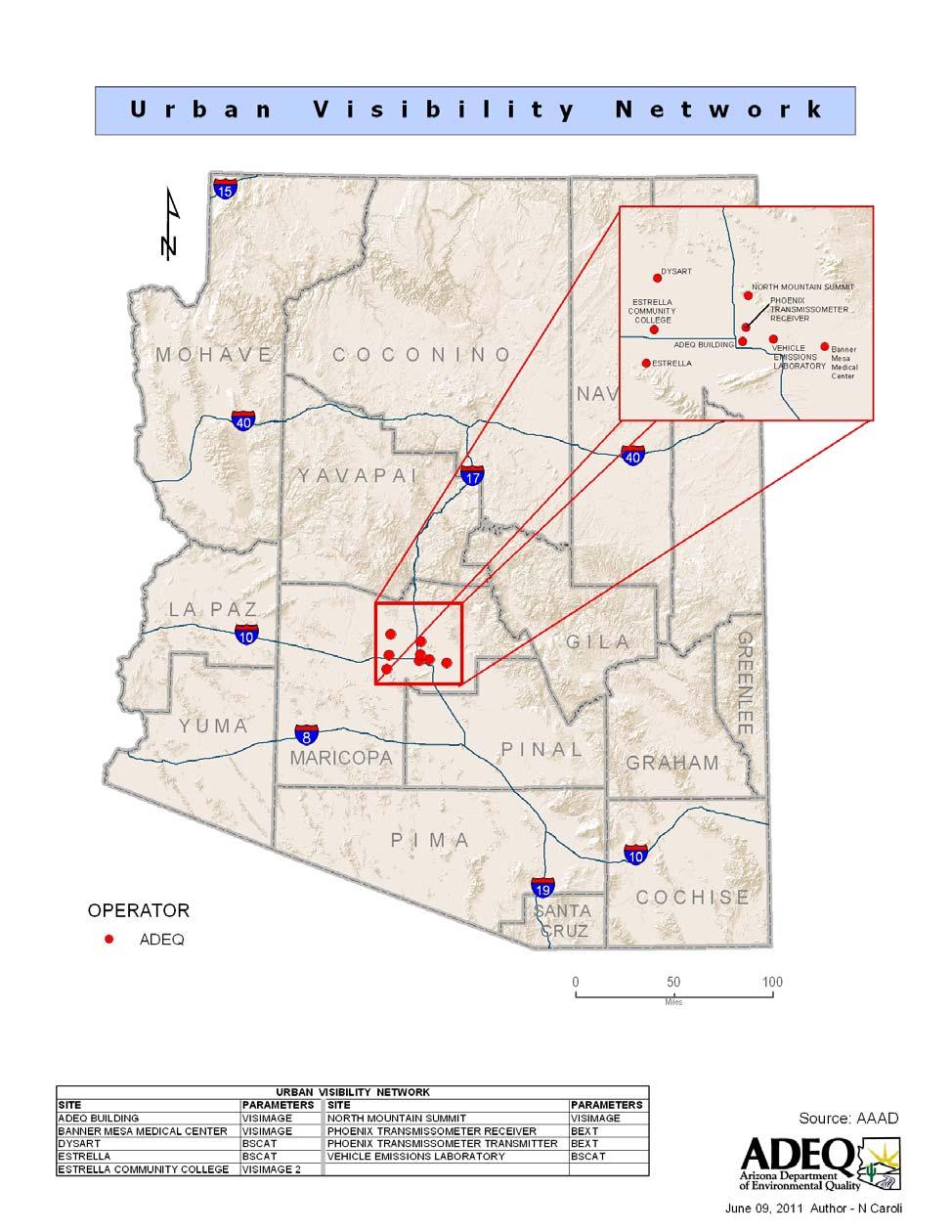
11 AIRNow was not able to process data in this format. ADEQ plans to renew these efforts to provide data to the AIRNow system and is currently working with their contractor to modify the existing AIRNow data transfer module. ADEQ hopes to utilize AIRNow s new AQCSV file format to transfer data to AIRNow Urban Haze Network Historically, ADEQ operated an urban haze network in the Phoenix and Tucson metropolitan areas. The purpose of the networks is to provide policy-makers and the public with information regarding urban haze levels, track short-term and long-term urban haze trends, assess source contributions to urban haze, and better evaluate the effectiveness of air pollution control strategies on urban haze. Equipment used to evaluate urban visibility includes transmissometers, nephelometers, particulate monitors, and digital camera systems. A wealth of urban visibility related data and information have been collected for more than a decade in both the Phoenix and Tucson area. Recently, due to budget cuts, this non-mandatory program was reduced to operate in the Phoenix Metropolitan Area only. This network includes the digital cameras and the nephelometers and transmissometer that support the AIRNow data reporting E-BAM Network of PM 10 Special Purpose Monitors The current network of E-BAM continuous particulate special purpose monitors (listed in Table 2.12) is composed of lightweight, portable monitors typically enclosed in self-contained, environmentally-sealed containers. They can be battery or solar powered for operation at sites without fixed electrical power. E- BAMs continuously sample and report particulate concentrations. Data are sampled every second and concentrations recorded every minute. E-BAM monitors have been used by many agencies, particularly in the western U.S., to provide continuous, real-time particulate concentration data that are useful for making informed smoke management decisions related to prescribed burns. E-BAM instruments are used for special purpose monitoring only. They are not classified as FRMs or FEMs and may not be used to demonstrate NAAQS compliance. ADEQ uses these monitors for temporary or short term monitoring of populated areas that could be impacted by smoke from controlled burns or for investigations of complaint responses. Historically, ADEQ s E-BAM monitors have been configured to measure particles 10 microns in diameter (PM 10 ). To get a better understanding of smoke impacts in these smaller communities, ADEQ is considering changing the configuration on these monitors to measure only particles 2.5 microns in diameter (PM 2.5 ). Hourly data from the E-BAM monitors can be viewed at: Table Location of E-BAM Monitors Site Name Address Flagstaff Middle School 755 N. Bonito, Flagstaff, AZ Prescott College AQD 336 Grove Ave, Prescott, AZ Sedona Post Office 190 W. Highway 89A, Sedona, AZ Show Low 561 E. Deuce of Clubs, Show Low, AZ Springerville 323 S. Mountain Ave., Springerville, AZ Verde Ranger Station 300 E. Highway 260, Camp Verde, AZ
12 3.0 Meeting Network Requirements ADEQ s monitoring networks meet the requirements specified in the CFR with one exception. The current sampling frequency for PM 2.5 is 1-in-6 instead of the required 1-in-3 at all sites except JLG Supersite where it is sampled at the required 1-in-3 frequency. As noted in ADEQ s 2010 Monitoring Network Plan, 1-in-3 is not possible due to factors such as the large distances from ADEQ to the sites. A second item that ADEQ will continue to monitor is the proposed O 3 monitoring requirements. If the current proposed requirements go final, this network may require the addition of a monitor in the Lake Havasu City -Kingman MSA. A search for a suitable site in the Lake Havasu City area is currently underway. ADEQ will continue to monitor the progress of the proposed O 3 monitoring requirements. The following subsection shows the requirements for PM 2.5 and is representative of the requirement formats for PM 10, O 3, PAMS, and NCore. The other subsections show the requirements for and/or uses of various other networks including SIP required monitoring, source compliance, Class I visibility, Urban Haze, meteorology, and AIRNow reporting network. 3.1 PM 2.5 Monitoring Network Requirements The number of PM 2.5 samplers required in urban areas is based on population (see Table 3.1-1) and design values for PM 2.5 concentrations (see Table 3.1-2). Table Minimum Number of PM 2.5 Monitors Required (40 CFR 58 Appendix D) Population (MSA) Most recent 3 yr design value 85% of any PM 2.5 NAAQS * Most recent 3 yr design value <85% any PM 2.5 NAAQS * >1,000, ,000 1,000, , , ** * 85% of Annual NAAQS (15 ug/m3) = ug/m3; 85% of 24-Hour NAAQS (35 μg/m3) = ug/m3 ** NCore sites require a minimum of one continuous and one FRM monitor The frequency of sample collection is based on the type of sampler and the design value calculated from data collected at each FRM (filter monitors) or FEM (continuous) sampler (see Table 3.1-1). 40 CFR Part (d)(1) gives the manual PM 2.5 sample collection frequency requirement at required SLAMS stations as every third day at sites without a collocated continuously operating PM 2.5 monitor. For SLAMS PM 2.5 sites with manual and continuous PM 2.5 monitors, the agency may request approval from the EPA Regional Administrator for a reduction to every sixth day and/or seasonal sampling schedule. Sites with design values ±10% of 35µg/m 3 (31.5 to 38.5µg/m 3 ) and sites where 24-hour values exceed the NAAQS for three consecutive years need an every third day frequency. Sites within ±5% of 35 µg/m 3 (33.25 to µg/m 3 ) need to operate on a daily schedule. ADEQ operates a network of six PM 2.5 sites throughout Arizona (see Table and Appendix A). Authority to operate PM 2.5 monitors has also been delegated to Maricopa, Pima, and Pinal counties. As can be seen in Tables and 1.1-1, at least two PM 2.5 monitors are required in the Phoenix and Tucson MSAs. These minimum PM 2.5 monitoring requirements are currently being met by local monitoring 12
13 agencies within these MSAs. As can be seen from Tables and 1.1-1, PM 2.5 monitoring may be needed within the MSAs of Prescott, Yuma, Flagstaff, and Lake Havasu-Kingman if previous PM 2.5 data are within 85% of any NAAQS. Previous PM 2.5 data exist for all of these MSAs except for the Lake Havasu-Kingman MSA. PM 2.5 data from all ADEQ sites are presented in Table Only the Nogales Post Office site exceeds 85% of any PM 2.5 NAAQS. While the JLG Supersite is a required PM 2.5 site for NCore and the Douglas and Yuma monitors may be needed for SIP purposes, the Flagstaff and Prescott Valley PM 2.5 monitors may be candidate sites for removal if future data show similar concentrations to the last two years. These two monitors were initially intended to be Special Purpose Monitors (SPM) to evaluate PM 2.5 concentrations in their respective geographical areas. The only MSA within the state of Arizona that does not contain a PM 2.5 monitor is the Lake Havasu-Kingman MSA. While not required, consideration may be given to operating a PM 2.5 monitor within this MSA sometime in the future. Table PM 2.5 Design Values and Sampling Frequencies (40 CFR 58.12) at ADEQ Sites Site Name hour Design Value (μg/m 3 ) Annual Design Value (μg/m 3 ) Exceeds 85% of either NAAQS Within ±10% of either NAAQS Current Sample Frequency Required Frequency Douglas Red Cross No No 1 in 6 1 in 3 Flagstaff Middle School* No No 1 in 6 1 in 3 JLG Supersite No No 1 in 3 1 in 3 Nogales Post Office Yes Yes 1 in 6 1 in 3 Prescott Valley * No No 1 in 6 1 in 3 Yuma Courthouse * No No 1 in 6 1 in 3 * Indicates design value calculations do not meet completeness criteria In addition to ADEQ s PM 2.5 FRM network, ADEQ also operates continuous samplers that are not FEMs at two monitoring sites; JLG Supersite and Nogales Post Office. The JLG supersite will be transitioning to a continuous FEM monitor to meet NCore requirements. Although the required frequency for all PM 2.5 FRM monitors is every third day, ADEQ operates only the monitor at JLG Supersite at this frequency. Based on the design values listed in Table 3.1-2, the Nogales Post Office would be a good candidate for an increased sampling frequency; however, the operation of a continuous PM 2.5 BAM monitor at this site makes the filter-based samplers eligible for a 1-in-6 sampling schedule. ADEQ plans to continue to operate the collocated FRMs at Nogales Post Office on this 1-in-6 sampling schedule. Sampling frequencies at the other sites have remained on the original every sixth day schedule established when the PM 2.5 program was started. Consideration of travel time, shipping costs, laboratory processing workload, and little change in annual values through time have discouraged changing to the more frequent monitoring schedule. 3.2 PM 10 Monitoring Network Requirements The number of PM 10 samplers required in urban areas is based on population (see Table 3.2-1) and design values for PM hour concentrations (see Table 3.2-2). ADEQ has delegated authority for monitoring PM 10 to Maricopa, Pinal, and Pima Counties, giving them responsibility for the monitoring network for 13
14 the MSAs within their counties. ADEQ's PM 10 monitoring network includes the MSAs in all other Arizona counties, as well as the PM 10 non-attainment areas in those counties. ADEQ operates a PMcoarse monitor (difference method using BAM instruments) in the Phoenix metropolitan area at the JLG Supersite NCore site. PM 10 concentrations are available from the PM 10 BAM instrument to support the multipollutant measurements at that site. Table Minimum Number of PM 10 Monitors Required (40 CFR 58 Appendix D) Population (MSA) High Concentration Exceeds 24-Hour NAAQS by 20% or more (>180µg/m 3 ) Medium Concentration Exceeds 80% of 24- Hour NAAQS (>120µg/m 3 ) Low Concentration Less than 80% of 24-Hour NAAQS (<120 µg/m 3 ) >1,000, ,000 1,000, , , , , The monitoring rule in 40 CFR Part (e) states that for PM 10 sites, the minimum monitoring schedule for the site in the area of expected maximum concentration shall be based on the relative level of that monitoring site s concentration with respect to the 24-hour standard. In rural areas of Arizona where there is only one PM 10 monitor to represent the area, such as Ajo, Hayden, and Yuma, sites can be considered de facto maximum-concentration sites whose operating frequencies must be determined using the Ratio-to-Standard diagram in 40 CFR Part (e). Due to the variability in PM 10 concentrations from year to year throughout Arizona, the operating frequencies of ADEQ PM 10 monitors will be evaluated every five years as part of the Five-Year Network Assessment. Table provides the design values and sampling frequencies for ADEQ s PM 10 monitors. During the last three years, ADEQ has converted several PM 10 sites from filter-based monitors to continuous monitors. This has occurred most recently at the Ajo, Hayden Old Jail, and Rillito sites. Continuous monitors in Yuma, Nogales, and at the JLG Supersite have been in operation for more than five years. It can be seen in Table that with the exception of Paul Spur Chemical Lime Plant, all PM 10 monitors that contain design values greater than zero or very near one have continuous monitors in place. The design value of 2 at Paul Spur Chemical Lime Plant is the result of one exceedance and is not representative of the historical data record. As a result, this site is not being considered for continuous sampling at this time. While ADEQ has no immediate plans to convert additional filter-based monitors to continuous monitors, ADEQ is trending towards more continuous monitoring at its PM 10 sites. Continuous PM 10 monitoring may be a more efficient monitoring methodology as less site visits are required. This becomes important for sites that require long travel times. Of the sites listed in Table 3.2-2, Bullhead City may be the next site that is considered for continuous PM 10 monitoring. It should also be noted that as of April 1, 2011, the Bethune Elementary School special purpose monitor is being considered for removal due to resource limitations. The surrounding Maricopa County PM 10 monitors would provide ample coverage for determination of attainment / non-attainment. Details will be provided in ADEQ s 2011 Monitoring Network Plan. 14
15 Table PM 10 NAAQS Design Value and Sampling Frequencies of ADEQ PM 10 Monitors Site Name Estimated Days PM 10 >150 (μg/m 3 ) Including Events Estimated Days PM 10 >150 (μg/m 3 ) Excluding Events Current Sample Frequency Historical Sample Frequency Ajo Continuous 1 in 6 Bullhead City in 6 1 in 6 Douglas Red Cross in 6 1 in 6 Flagstaff Middle School in 6 1 in 6 Hayden Old Jail Continuous 1 in 6 Bethune Elementary School in 6 1 in 6 (SPM) JLG Supersite 0 0 Continuous 1 in 6 and Continuous Nogales Post Office in 6 and Continuous 1 in 6 and Continuous Paul Spur Chemical Lime Plant in 6 1 in 6 Payson Well Site in 6 1 in 6 Prescott Valley in 6 1 in 6 Rillito Continuous 1 in 6 Yuma Supersite Continuous 1 in 6 and Continuous 1 Indicates design value calculations do not meet completeness criteria 2 Filter-based and continuous records merged to calculate design value 3 Continuous records from Yuma Courthouse and Yuma Supersite merged to calculate design value ADEQ operates collocated PM 10 monitors at two sites, Paul Spur Chemical Lime Plant and Payson Well Site, although the minimum required is only one. ADEQ may consider closing one of the monitors at one of those sites at some time in the future. 3.3 Ozone Monitoring Network Requirements ADEQ operates a network of seven O 3 monitors throughout Arizona (see Table and Appendix A). Authority to operate O 3 monitors has also been delegated to Maricopa, Pima, and Pinal counties. For 15
16 areas that ADEQ is responsible for O 3 monitoring, the ADEQ O 3 network meets the minimum requirements that are currently set forth in 40 CFR 58 Appendix D. Table Minimum Number of O 3 Monitors Required (40 CFR 58 Appendix D) Population (MSA) Most recent 3 year 8-hour Design Value 85% of NAAQS (0.075 ppm) Most recent 3 year 8- hour Design Value <85% NAAQS (0.075 ppm) >10 Million Million ,000-4 Million , , * * NCore sites require a minimum of one monitor; Proposed monitoring requirements would require 1 monitor for the 50, ,000 population category regardless of design value Based on the proposed changes in the O 3 monitoring requirements (dated July 8, 2009), the ADEQ O 3 network, in conjunction with other agency O 3 networks, appears to be meeting some of these proposed changes. Specifically, ADEQ s Alamo Lake site in conjunction with the NPS sites (Grand Canyon, Petrified Forest, and Chiricahua NM) should adequately cover the proposed O 3 -sensitive ecosystem portion of the non-urban O 3 network. If the NPS sites are used to meet this requirement, ADEQ will likely need to modify the degree of their quality assurance oversight for the NPS monitors. It is possible that ADEQ will need to perform annual performance evaluations for these NPS O3 sites. ADEQ s Tonto National Monument O 3 monitor will likely meet the proposed urban, downwind transport scenario. The EPA is also proposing O 3 monitoring in one smaller urban area within a μsa. Possible locations that would fulfill this requirement would include any of the areas listed in Table Based on the proposed monitoring rule, one possible deficiency in the ADEQ O 3 network would be the lack of monitoring in the Lake Havasu Kingman MSA. Once the O 3 monitoring rule is finalized by July, 2011, the ADEQ O 3 network will be fully assessed and any changes to the monitoring requirements will be addressed in the annual monitoring network plans. During the 2009 ADEQ Network Plan and review, ADEQ identified a possible siting issue with the Prescott College AQD O 3 monitor. ADEQ continues to search for a new site in the Prescott area and plans to relocate the Prescott College AQD monitor during the 2011 O 3 season or prior to the start of the 2012 O 3 season. ADEQ has also begun a preliminary search for a suitable site in the Lake Havasu Kingman MSA in anticipation of new O 3 monitoring requirements. While the state of Arizona has an official O 3 monitoring season of January December, ADEQ was granted permission by EPA Region 9 to operate monitors from April October. This alternative O 3 season will be re-evaluated following the O 3 final rule which is to be published in July, Depending on the finalized O 3 NAAQS, O 3 seasons may need to be expanded to cover the month of March. 16
17 Table O 3 Design Values at ADEQ Sites Site Operating Schedule hour Design Value (ppm) Alamo Lake April October Flagstaff Middle School April October JLG Supersite January December Prescott College AQD * April October Queen Valley April October Tonto National Monument April October Yuma Supersite April October * Based on incomplete data (2008). 3.4 Sulfur Dioxide Monitoring Network Requirements ADEQ operates a network of three sulfur dioxide (SO 2 ) monitors throughout Arizona. Authority to operate SO 2 monitors has also been delegated to Maricopa and Pima counties. ASARCO LLC and Freeport MacMoRan Copper and Gold Inc. also operate SO 2 monitoring networks in Gila County for compliance purposes to support SIP requirements. The SO 2 monitoring requirements set forth in 40 CFR Part 58 Appendix D is based on a Populated Weighted Emissions Index (PWEI) that is calculated for each CBSA. CBSAs with PWEIs greater than 5,000 require at least one SO 2 monitor. CBSAs with PWEIs greater than 100,000 require a minimum of two SO 2 monitors. Table shows the PWEI for each CBSA and the number of required monitors. The Phoenix-Mesa-Glendale metropolitan area is the only area within the state of Arizona that requires ambient monitoring of SO 2 based on PWEI values. The current SO 2 monitors operated by Maricopa and Pima counties meet or exceed the current monitoring requirements set forth in 40 CFR Part 58 Appendix D. ADEQ will continue to operate at least one SO 2 monitor in the Hayden and Miami areas to support the local facility networks. ADEQ has been working with these facilities to acquire their SO 2 ambient monitoring data for reporting to EPA s Air Quality System (AQS) database. ADEQ will continue to work with these facilities to review and report ambient SO 2 data to the AQS database where compliance with the SO 2 standard can be easily monitored. ADEQ will continue to perform annual performance evaluations for these facilities SO 2 monitors. ADEQ also operates a trace-level SO 2 monitor at its NCore site; JLG Supersite, as required in 40 CFR Part 58 Appendix D. 17
18 Table Minimum Number of SO 2 Monitors Required (40 CFR 58 Appendix D) CBSA County 2008 SO 2 Tons-per- Year Population Weighted Index (PWEI) Number of Monitors Required None Apache 22, Sierra Vista-Douglas Cochise Flagstaff Coconino Payson Gila 29, Safford Graham & Greenlee Phoenix-Mesa- Glendale Maricopa & Pinal Lake Havasu- Kingman Mohave Show Low Navajo 19, Tucson Pima Nogales Santa Cruz Prescott Yavapai Yuma Yuma Nitrogen Dioxide Monitoring Network Requirements ADEQ operates one nitrogen dioxide (NO 2 ) monitor throughout the state of Arizona. This NO 2 monitor is located at the JLG Supersite. Authority to operate NO 2 monitors has also been delegated to Maricopa and Pima counties. The NO 2 monitoring requirements set forth in 40 CFR Part 58 Appendix D are based on a combination of CBSA population and Annual Average Daily Traffic (AADT) counts. The first requirement to be considered is the CBSA population. CBSAs with populations greater than 500,000 are required to operate one near roadway monitor, while CBSAs with populations greater than 2.5 million are required to operate two near roadway monitors. Additionally, CBSAs with populations greater than 500,000 which also contain roadway segments with 250,000 or greater AADT also require two near roadway monitors. As can be seen in Table 3.4-1, two CBSAs (Phoenix and Tucson Metro areas) within the state of Arizona contain populations greater than 500,000 and therefore require at least one NO2 near roadway monitor. The Phoenix CBSA also exceeds the 2.5 million population requirement as well as the 250,000 AADT requirement, therefore two near roadway monitors are needed in the Phoenix CBSA. The required near roadway monitors in Tucson and Phoenix will be operated by the local monitoring agencies in their respected areas. It can be seen in Table that no other CBSA within the state exceeds the population or AADT criteria for near roadway monitoring, therefore ADEQ is not required to operate such monitors. 18
19 In addition to the near roadway monitoring requirements set forth in 40 CFR Part 58 Appendix D, there is also a requirement for area-wide NO 2 monitoring. CBSAs with populations of one million or more require one NO 2 monitor to measure NO 2 concentrations that represent neighborhood or larger spatial scales. The Phoenix and Tucson metropolitan areas are the only areas within the state of Arizona that require ambient monitoring of NO 2. The current NO 2 monitors in place that are operated by Maricopa and Pima counties meet or exceed the current monitoring requirements set forth in 40 CFR Part 58 Appendix D. While ADEQ does operate one NO x monitor at the JLG Supersite, this monitor is not technically required by the NO 2 network design or for the NCore network. However, NO x monitoring is required as part of the PAMS program for Type 2 PAMS sites, therefore NOx would need to be monitored at least during the months of June, July, and August at JLG Supersite. It may make sense to keep this monitor operating year round so that additional information can be gathered regarding NO y /NOx data comparisons. Table Minimum Number of NO 2 Monitors Required (40 CFR 58 Appendix D) CBSA County 2009 Population Estimate 2009 Maximum AADT Number of Near Roadway Monitors Required Number of Area-Wide Monitors Required None Apache 70,591 NA 0 0 Sierra Vista-Douglas Cochise 128,518 NA 0 0 Flagstaff Coconino 129,849 40, Payson Gila 52,199 NA 0 0 S afford Graham & Greenlee 45,086 NA 0 0 None La Paz 20,012 NA 0 0 Phoenix-Mesa- Glendale Maricopa & Pinal 4,364, , Lake Havasu- Mohave 194,825 34, Kingman Show Low Navajo 112,975 NA 0 0 Tucson Pima 1,020, , Nogales S anta Cruz 43,771 NA 0 0 Prescott Y avapai 215,686 38, Yuma Yuma 196,972 37, Carbon Monoxide Monitoring Network Requirements ADEQ operates one carbon monoxide (CO) monitor throughout Arizona. This CO monitor is a trace level monitor that is located at the JLG Supersite to fulfill NCore monitoring requirements. Authority to operate CO monitors has also been delegated to Maricopa and Pima counties. There are no CO minimum monitoring requirements set forth in 40 CFR Part 58 Appendix D, however, continued operation of CO monitors is required until discontinuation is approved by the EPA Regional Administrator. While there 19
20 are no minimum monitoring requirements for CO set for in 40 CFR Part 58 Appendix D, the EPA has recently proposed new monitoring requirements for CO. Except for those CO monitors that are required as part of the NCore network, the proposed monitoring requirements would not require any area-wide CO monitors. However, the proposed monitoring requirements would require near roadway CO monitors in CBSAs with populations of one million or greater. These near roadway CO monitors would be collocated with the NO2 near roadway monitoring stations. Since the Tucson and Phoenix CBSAs both exceed the one million population requirement set forth in the proposed rule, the number of near roadway CO monitors would be identical to the number of near roadway NO 2 monitors. The required near roadway monitors in Tucson and Phoenix will be operated by the local monitoring agencies in their respected areas. The one CO monitor that is currently operated by ADEQ meets the minimum monitoring requirements for both the NCore and CO network design criteria set forth in 40 CFR Part 58 Appendix D. 3.7 Lead Monitoring Network Requirements ADEQ operates three Pb monitors at two sites throughout Arizona. These Pb monitors were installed in October, 2010 and were collecting valid data by January, The monitors are located at the Globe Highway site near Hayden, AZ and at the Miami Golf Course site in Miami, AZ. These monitors were required by the original Pb monitoring rule which required ambient monitors near sources that exceeded one ton of Pb emissions annually. This rule was revised and finalized in December The revised rule decreased the Pb emissions threshold to ½ ton and required ambient Pb monitors at all NCore sites in CBSAs with a population of 500,000 or more instead of using only a 500,000 population threshold as was stated in the original monitoring rule. A second review of Pb emissions data from sources throughout Arizona found that no other sources exceeded the ½ ton Pb emissions threshold; therefore, no additional Pb monitors are needed near sources. Based on the revised monitoring rule, ADEQ will install a Pb monitor at its NCore site; JLG Supersite. This monitor will be installed by the end of The NCore site in Tucson, AZ will also require a Pb monitor. This monitor will be installed and operated by Pima County DEQ. 3.8 SIP Monitoring Network Requirements ADEQ is responsible for preparation and submittal of SIPs to EPA for the non-attainment and maintenance areas in Arizona. ADEQ is also responsible for conducting ambient air monitoring for these areas with the exception of the delegated agreements with Maricopa, Pima, and Pinal counties and tribal lands. Select permitted sources are also responsible for monitoring air quality, if they are the largest source of emissions for that area. Some monitoring sites are specifically named in some SIPs; other monitoring sites are not specifically named, but are representative of the air quality in that SIP area. Table 3.8 lists the ADEQ and source-operated monitors used to determine SIP compliance. Table 3.8 SIP Network Monitoring Requirements Note: Sites in italics are specifically required in SIP; others meet the general SIP requirement that representative monitoring be conducted (no specific monitoring sites named in SIP). Area and County Pollutant Classification ADEQ SIP Sites Phoenix, Maricopa CO Maintenance/Attainment JLG Supersite 20
21 Area and County Pollutant Classification ADEQ SIP Sites Phoenix, Maricopa O 3 1-hr Maintenance/Attainment JLG Supersite, Tonto National Monument Phoenix-Apache Junction, Maricopa and Pinal Ajo, Pima O 3 8-hr Basic Nonattainment Alamo Lake, JLG Supersite, Queen Valley, Tonto National Monument PM 10 Moderate Nonattainment Ajo Bullhead City, Mohave PM 10 Maintenance/Attainment Bullhead City (Post Office) Douglas, Cochise PM 10 Moderate Nonattainment Douglas Red Cross ADEQ also operates one PM 10 site at the Agua Prieta Fire Station in Mexico. Paul Spur, Cochise PM 10 Moderate Nonattainment Paul Spur Chemical Lime Plant Hayden, Gila and Pinal PM 10 Moderate Nonattainment Hayden Old Jail Miami, Gila PM 10 Moderate Nonattainment Freeport McMoRan sites: Golf Course & Miami Ridgeline Nogales, Santa Cruz PM 10 Moderate Nonattainment Nogales Post Office ADEQ also operates one PM 10 site at Nogales Fire Station in Mexico. Payson, Gila PM 10 Maintenance/Attainment Payson Well Site Phoenix, Maricopa, and Pinal (Apache Junction portion) PM 10 Serious Nonattainment JLG Supersite Phoenix (Salt River Area) Rillito, Pima PM 10 Moderate Nonattainment Rillito Both ADEQ and the source, APCC, operate instruments at this site. Yuma, Yuma PM 10 Moderate Nonattainment Yuma Supersite Nogales, Santa Cruz PM 25 Nonattainment Nogales Post Office Ajo, Pima SO 2 Maintenance/Attainment No network or commitment Douglas, Cochise SO 2 Maintenance/Attainment No network or commitment Hayden, Gila and Pinal SO 2 Nonattainment Primary ADEQ: Hayden Old Jail ASARCO (5 SO 2, 3 MET [no met at Jail or Garfield]): Globe Hwy, Garfield Ave., Montgomery Ranch, Hayden Old Jail, Hayden Junction Miami, Gila SO 2 Nonattainment Primary ADEQ: Miami Ridgeline Freeport McMoRan (SO 2, MET) Jones Ranch, Miami Townsite 21
22 Area and County Pollutant Classification ADEQ SIP Sites Morenci, Greenlee SO 2 Maintenance/Attainment No network or commitment San Manuel, Pima and SO 2 Maintenance/Attainment No network or commitment Pinal Regional Haze, 12 Class I areas Visibility Impairing pollutants (VOC, NOx, SO 2, PM 10, PM 2.5, PM 2.5 species) Statewide IMPROVE monitors 3.9 Source Compliance Monitoring Network Requirements ADEQ Protocol sites: Douglas Red Cross, Organ Pipe Natl Monument, JLG Supersite, Queen Valley, Saguaro West Natl Monument National Park Service sites: Chiricahua Entrance Station, Greer Water Treatment Plant, Indian Gardens-Grand Canyon, Hance Camp-Grand Canyon, Ike s Backbone, Meadview, Petrified Forest National Park, Pleasant Valley Ranger Station, Saguaro National Park-East, Sycamore Canyon, Tonto National Monument ADEQ requires several of the major point sources in the state to conduct ambient monitoring for selected pollutants in and around their facilities. Some requirements are for PSD monitoring prior to operation of the facility. Other monitoring requirements are for the duration of the permit. ADEQ activities have been limited to regular performance evaluation audits of some equipment at these sites and review of ambient data submitted according to permit requirements. Recently, ADEQ has begun to submit a portion of these data to the EPA AQS database to support SIP compliance. ADEQ continues to work with these major point sources to acquire the ambient air quality data that are required to be submitted to EPA s AQS database. Sources are required to review their data and submit quality assurance documents to ADEQ with the data. Table 3.9 lists the monitors operated by ADEQ permitted sources. Table 3.9 Source Compliance Monitoring Network Site Name City Pollutant(s) AQS Submittal APCC Rillito Rillito PM 10, Meteorology No ASARCO Globe Highway Winkelman SO 2 W orking with facility to submit data to AQS ASARCO Hayden Garfield Ave. Hayden SO 2 W orking with facility to submit data to AQS ASARCO Montgomery Ranch Hayden SO 2 W orking with facility to submit data to AQS ASARCO Hayden Junction Hayden Junction SO 2 No ASARCO Hayden Old Jail Hayden SO 2 No 22
23 Chemical Lime Plant Nelson Meteorology No Drake Cement Sycamore Canyon PM 10, PM 2.5 mass and ammonium speciation, Meteorology No FMMI Miami Ridgeline Miami PM 10 mass and metals speciation Yes, begin w/ 2002 data FMMI Golf Course Miami PM 10 mass and metals speciation, collocated Yes, begin w/ 2002 data FMMI Miami Jones Ranch Miami SO 2 FMMI Miami Townsite Miami SO 2 Working with facility to submit data to AQS Working with facility to submit data to AQS PCC Clarkdale NW Clarkdale PM 10 mass and metals speciation, Meteorology No PCC Clarkdale SE Clarkdale PM 10 mass and metals speciation, Meteorology No Carlota Mine Sanctuary Globe PM 10, Sulfuric acid mist, Meteorology No TEP Springerville Coyote Hills Springerville NO 2, PM 10, SO 2, Meteorology No TEP Springerville Coal Yard Springerville PM 10 No 3.10 Class I Visibility Network Visibility monitoring networks track impairment in specified national parks and wilderness areas. These parks and wilderness areas are called Class I Areas and were designated based on an evaluation required by Congress in the 1977 Federal CAA Amendments. The evaluation which was performed by the USFS and NPS reviewed the wilderness areas of parks and national forests which were designated as wilderness before 1977, were more than 6,000 acres in size, and have visual air quality as an important resource for visitors. Of the 156 Class I Areas designated across the nation, 12 are located in Arizona. For the Class I Area designations, EPA initiated a nationally-operated monitoring network in 1987 called the Interagency Monitoring of PROtected Visual Environments (IMPROVE) program. The purpose of the network is to characterize broad regional trends and visibility conditions using monitoring data collected in or near Class I Areas across the U.S.. Originally, the national IMPROVE network was made up of approximately 30 sites at Class I areas. During the number of sites increased to approximately 110. ADEQ, Pima and Pinal counties, and federal land managers at Arizona's Class I Areas cooperatively operate the visibility monitoring network in Arizona. The current network is described in Table In 23
24 addition to the Class I IMPROVE monitors listed in Table 3.10, ADEQ also operates one IMPROVE monitor at the Douglas Red Cross site, and collocated monitors at the JLG Supersite. These sites serve as urban IMPROVE monitors. The Douglas Red Cross site also serves as a border region IMPROVE site. See Appendix A for a spatial representation of the IMPROVE monitoring network and Class I areas within the state of Arizona. Table Arizona Class I Visibility Monitoring Network Geographic Area Represented Background Chiricahua National Monument, Chiricahua Wilderness Area and Galiuro USFS Wilderness Grand Canyon National Park Mazatzal and Pine Mountain USFS Wilderness Mount Baldy Petrified Forest National Park Saguaro National Park Sierra Ancha USFS Wilderness Superstition USFS Wilderness Sycamore Canyon USFS Wilderness Monitoring Location Meadview, Organ Pipe National Monument Chiricahua Entrance Station Hance Camp and Indian Gardens Ike s Backbone Greer Water Treatment Plant Petrified Forest East Unit and West Unit Pleasant Valley Ranger Station Tonto National Monument, Queen Valley Sycamore Canyon (Camp Raymond) ADEQ's 1996 monitoring plan for the Arizona Class I areas proposed adding optical and meteorological monitoring equipment to existing IMPROVE sites to supplement data collected by the IMPROVE aerosol monitors with continuous measurements to better characterize the air quality in these areas. ADEQ s 2002 Class I Area Visibility monitoring plan proposed to established protocol sites (completely supported by ADEQ following IMPROVE monitoring requirements) to supplement the IMPROVE network coverage. Part of the motivation for installing integrating nephelometers at IMPROVE sites was a desire to use short term (five minutes) visibility estimates to model the visual experience of a visitor to a Class I area. A second motivation for installing nephelometers at IMPROVE sites was to provide input to mathematical algorithms that create values that can be compared with the IMPROVE measurements to test the performance of the IMPROVE algorithm. Both the original and the revised IMPROVE algorithms tend to over-estimate the lowest extinction values typical of the Arizona IMPROVE sites. Due to budget constraints, ADEQ shut down the Class I nephelometer network in Over a decade of data were collected at several of these nephelometer sites. In early 2011, a draft summary report was written which summarizes the nephelometer data that were collected since The report provides comparisons of calculated visibility impairment between the IMPROVE aerosol monitors and collocated nephelometers. Summaries and trends in visibility data are also presented within the report, as well as meteorological data summaries in the form of wind roses. This report is meant to serve as a final data summary for the Class I Nephelometer network. Information from this report may be utilized in the future if further modifications are needed to the Arizona Class I visibility network Urban Haze Monitoring Network Historically, ADEQ monitored the Phoenix and Tucson metropolitan areas with a network of instruments to characterize and quantify the extent of urban haze. There are no established federal or state standards 24
25 for acceptable levels of urban haze. ADEQ began studying the nature and causes of urban haze by conducting studies during the winter of in Phoenix and during the winter of in Tucson. These studies recommended long-term, year-round monitoring of visibility. In 1993, ADEQ began deploying visibility monitoring equipment in Phoenix and Tucson. These visibility monitoring data were needed to provide policymakers and the public with information, track short and long-term trends, assess source contributions to urban haze, and better evaluate the effectiveness of air pollution control strategies. Equipment currently used to evaluate urban visibility includes transmissometers, nephelometers, particulate monitors, and digital camera systems. The Phoenix urban haze network consists of a transmissometer for measuring light extinction along a fixed path length of four and a half kilometers, three nephelometers for measuring light scattering, five digital camera systems to record visual characteristics of the urban area, and particulate filters for quantifying and characterizing particulate matter. Due to budget constraints, the Tucson urban haze network was shut down in September, Approximately a decade of urban haze data were collected in the Tucson area. In early 2011, a draft summary report was written which summarizes the nephelometer and transmissometer data that were collected since The report provides summaries and trends in urban visibility data, as well as meteorological data summaries in the form of wind roses. This report is meant to serve as a final data summary for the Tucson Urban Haze network. Information from this report may be utilized in the future if further modifications are needed to the Urban Haze Network. The urban haze sites (and their status) are described in Table
26 Table 3.11 Urban Haze Monitoring Network Site Name Parameter(s) Measured Phoenix Network Operational ADEQ Building High Resolution Digital Camera Banner Mesa Medical Center High Resolution Digital Camera Dysart Light Scattering (Bscat) Nephelometer Estrella Light Scattering (Bscat) Nephelometer Estrella Mountain Community College 2 High Resolution Digital Cameras JLG Supersite IMPROVE North Mountain High Resolution Digital Cameras Phoenix Transmissometer Transmissometer (Bext) (Phoenix Baptist Hospital to Holiday Inn Hotel) Vehicle Emissions Laboratory Light Scattering (Bscat) Nephelometer Tucson Network Closed September, nd St./Craycroft Light Scattering (Bscat) Nephelometer Children's Park Light Scattering (Bscat) Nephelometer Tucson Transmissometer Transmissometer (Bext) (U of A Clinical Science Building to Pima County Health & Welfare Building) 3.12 Meteorology Monitoring Network ADEQ operates meteorological equipment at selected sites throughout its network. Some sites were originally established because other meteorology networks (NWS, AZMet, etc.) were not located near ADEQ's ambient air quality sites. While monitoring of meteorological parameters is not required for SLAMS sites, the EPA does recommend meteorological monitoring when possible. Meanwhile, some meteorological equipment is required for PAMS and NCore sites. ADEQ currently meets these monitoring requirements at the JLG Supersite (both a PAMS and NCore site) and VEI (supplemental PAMS), but as of April 1, 2011, does not contain any meteorological equipment at the PAMS Type 3 site Queen Valley. ADEQ is considering adding standard meteorological measurements to all of the air quality monitoring sites. These additions to the meteorological monitoring network will occur as instrumentation and funding is available. The Queen Valley site will likely be the first site considered for expanding the meteorological monitoring network. See Table 3.12 for a summary of the current ADEQ meteorological monitoring network as of March 1,
27 Table 3.12 Meteorology Monitoring Network as of 4/1/2011 Site Temp. Temp. Lapse Rate System Relative Humidity Wind Total Horizontal Solar Radiation Ultraviolet Solar Radiation Wind Profiler Report to AQS Comments Ajo X No JLG Supersite Hayden Old Jail X X X Yes X X X No For PAMS support & NCore Nogales Post Office Paul Spur Chemical Lime Plant - South X X No No Payson Well Site X X X No Rillito X X X No Vehicle Emissions Laboratory X X X X X X X Solar only For PAMS support Yuma Supersite X X X No 3.13 AIRNow Reporting Network ADEQ originally began reporting PM 2.5 data (converted from nephelometer light scatter measurements) from four sites in the Phoenix metropolitan area: JLG Supersite, Dysart, Estrella, and VEI. ADEQ's air quality forecasters use these data for daily forecast reports for Phoenix. This data reporting began for the Phoenix metropolitan area because continuous PM 2.5 instruments were not in operation. Since reporting began, Maricopa County Air Quality Department has begun operating several continuous PM 2.5 instruments and also began reporting their data to AIRNow. Due to budget constraints, ADEQ closed its JLG Supersite nephelometer. A continuous PM 2.5 monitor operates at the site but the data are not reported 27
28 to AIRNow. ADEQ plans to work with MCAQD to assess the PM 2.5 instruments reporting to AIRNow for further optimization. ADEQ's Data Collection System (DCS) was modified several years ago to produce XML files in AIRNow format, when AIRNow was updating its system. While it was AIRNow s initial intent to accept XML formatted data, this capability had fallen behind schedule, and they have since gone to a new data format for data transfer. If funding is available, ADEQ may need to re-engineer the DCS to produce data in a format that is acceptable by AIRNow. ADEQ hopes to report all NAAQS pollutant data to AIRNow to aid forecasters in providing accurate pollution forecasts to the citizens of Arizona. Pima, Pinal, and Maricopa Counties all report data to AIRNow, and with the proposed addition of ADEQ data, AIRNow could serve as a centralized database to display near-real time data for all areas of Arizona. 4.0 Conclusions The purpose of this Five-Year Network Assessment is to: a) Determine whether the network meets the monitoring objectives A review of the ADEQ monitoring network and the monitoring requirements for each network and NAAQS pollutant has been presented. Based on the review provided, the siting and operation of ADEQ s monitoring networks meet the requirements of 40 CFR Part 58, including its Appendices A, C, D, and E. 40 CFR Part (d)(1) gives the manual PM 2.5 sample collection frequency requirement at required SLAMS stations as every third day for sites without a collocated continuously operating PM 2.5 monitor. For SLAMS PM 2.5 sites with manual and continuous PM 2.5 monitors, the agency may request approval from the EPA Regional Administrator for a reduction to every sixth day and/or seasonal sampling schedule. ADEQ operates only the monitor at JLG Supersite at the required 1-in-3 day frequency. Sampling frequencies at the other sites have remained on the original every sixth day schedule established when the PM 2.5 program was started. Consideration of travel time, shipping costs, laboratory processing workload, and little change in annual values through time have discouraged changing to the more frequent monitoring schedule. b) Whether new sites are needed or existing sites can be terminated Based on the proposed changes in the O 3 monitoring requirements (dated July 8, 2009), the ADEQ O 3 network, in conjunction with other agency O 3 networks, appears to be meeting the proposed monitoring requirements. Specifically, ADEQ s Alamo Lake site in conjunction with the NPS sites (Grand Canyon, Petrified Forest, and Chiricahua NM) should adequately cover the proposed rural O 3 network. ADEQ s Tonto National Monument O 3 monitor will likely meet the proposed urban, downwind transport scenario. Based on the proposed monitoring rule, one possible deficiency in the ADEQ O 3 network would be the lack of monitoring in the Lake Havasu Kingman MSA. Additionally, based on the proposed O 3 monitoring requirements, ADEQ may need to consider O 3 monitoring in one of the smaller CBSAs. Sierra Vista may be a candidate location. Once the O 3 monitoring rule is finalized in July, 2011, the ADEQ O 3 network will be fully assessed and any changes to the monitoring requirements will be addressed. ADEQ has recently added Pb monitoring sites at Globe Highway (source oriented) and Miami Golf Course (source-oriented). ADEQ will also be installing a Pb monitor at the JLG Supersite to fulfill the Pb 28
29 NCore requirement. ADEQ is currently considering the monitoring methodology options at JLG Supersite (Hi-Vol vs. low-volume PM 10 ), but will have a Pb monitor installed by December, ADEQ made reductions to both the Class I and urban visibility networks. ADEQ discontinued operations of the nephelometers at nine Class I visibility sites in 2010 due to budget constraints. This visibility component was not required by the IMPROVE program, the CFR, or by the Regional Haze Rule SIP, and was funded solely by ADEQ. ADEQ also made reductions to the urban visibility network in Additional considerations included the use of the data by other agencies and the resources needed for operations and data processing. The purpose of the urban visibility network was to provide policy-makers and the public with information regarding urban haze levels, track short-term and long-term urban haze trends, assess source contributions to urban haze, and better evaluate the effectiveness of air pollution control strategies on urban haze. These networks had accumulated data for more than a decade and had no corresponding regulatory or SIP based monitoring requirements. In early 2011, a draft summary report was created which summarized these data. ADEQ has discovered that the Queen Valley PAMS site does not meet the monitoring requirements set forth in 40 CFR Part 58 Appendix D. Surface meteorology is required at all PAMS sites and Queen Valley does not meet this surface meteorology requirement. ADEQ will focus on expanding their meteorology monitoring network over the next five years and the Queen Valley site will be amongst the first considered for this expansion. ADEQ has determined that the Bethune Elementary School PM 10 monitor is no longer needed. Current and ongoing budgetary limitations require the redirection of non-essential (non-regulatory) resources. ADEQ no longer has the resources to conduct monitoring that is not required by regulation. The Bethune Elementary School monitor is an SPM and not required by the CFR. Additionally, the Maricopa County Air Quality Department s PM 10 network provides sufficient coverage for attainment / nonattainment determinations in Maricopa County. ADEQ has identified Carbonyl monitoring in support of the PAMS program at JLG Supersite to be nonessential. In 2006, EPA removed the requirement to measure carbonyls at PAMS sites except for those areas classified as Severe or Extreme. The Phoenix area is classified as Serious; therefore, PAMS threehour carbonyl monitoring is not required at either of ADEQ s PAMS sites. Additionally, 24-hour carbonyl sampling already occurs at the JLG Supersite as part of the NATTS network. Based on this analysis, ADEQ may consider suspending PAMS carbonyl monitoring in the future. c) Whether new technologies are appropriate for incorporation in the ambient air monitoring network. ADEQ will identify, acquire, and implement ambient air monitoring equipment that is based on new technologies and improves efficiencies and effectiveness in ADEQ s monitoring networks. New technologies will be analyzed and possibly acquired as they become available and as funding and ADEQ s resources permit. Trace level gas monitors, PM coarse monitors, and an upgraded communications system are some examples of projects that are currently underway. ADEQ is currently working on expanding its digital data collection capabilities and is also moving toward remote zeros and spans with newly acquired O 3 analyzers. These new technologies have been or will be implemented first at ADEQ s NCore site; JLG Supersite. Upon successful implementation, these new technologies will be expanded to other sites throughout ADEQ s monitoring network. 29
30 d) The network assessment must consider the ability of existing and proposed sites to support air quality characterization for areas with relatively high populations of susceptible individuals (e.g., children with asthma), and, for any sites that are being proposed for discontinuance whether the network has considered high populations of susceptible populations, The ADEQ monitoring network design is based on air monitoring regulatory requirements and SIP requirements. The monitoring network considers several monitoring objectives including monitoring for public exposure during the design review. JLG Supersite is the site of ADEQ s NCore, CSN, and NATTS networks which support air quality characterizations for highly susceptible populations in the Phoenix Metro Area. ADEQ however, has not made any specific evaluations or systematic review of its network compared to public health data on areas of high populations with susceptible individuals. ADEQ is however, aware of public and children s health issues and has specific programs that support the Children s Health Initiative. Additionally, information from the ambient air monitoring network is used to provide daily pollution forecasts so that health risk decisions can be made by schools, public health agencies, health care providers, and others. e) And if site are to be discontinued, the effect on other data uses and nearby jurisdictions ADEQ takes many considerations into account before discontinuation of existing monitors. Among these are communications with nearby jurisdictions and other data users. Prior to the discontinuation of a site or monitor, every effort is made to ensure compliance with regulatory requirements is not compromised. f) For PM 2.5, must identify changes to the population oriented sites. The number of PM 2.5 samplers required in urban areas is based on population (see Table 3.1-1) and design values for PM 2.5 concentrations (see Table 3.1-2). The location of ADEQ s PM 2.5 monitors is shown in the PM 2.5 map in Appendix A and includes Nogales, JLG Supersite, Flagstaff, Yuma, Douglas and Prescott. Monitoring is not required within the MSAs of Prescott and Flagstaff; therefore, ADEQ may consider removing these monitors if ambient monitoring data continue to be well below the PM 2.5 NAAQS. 30

31 Appendix A Network Maps ADEQ Five Year Network Assessment 31
32 32
33 33
34 34
35 35
36 36
37 37
38 38

39 39
40 40