Charlton Flood and Drainage Management Plan. Charlton Town Hall 29 February 2012
|
|
|
- Jacob Martin
- 5 years ago
- Views:
Transcription

1 Charlton Flood and Drainage Management Plan Charlton Town Hall 29 February 2012
2 Community Meeting Principles Reflection on the past to better plan for the future CMA and Shire is seeking to understand Wanting to hear all views allow others to contribute All perspectives are valid
3 Overview Progress of the Plan Flood Modelling Results Flood Mitigation Options Wanting to hear all views allow others to contribute
4 Purpose of the Plan Better understand flooding in Charlton Improve future flood warnings Identify potential flood mitigation options Recommend to government preferred mitigation option Community supported Practical and achievable
5 Progress of the Plan 55% complete Flood model is complete Results of January 2011 and September 2010 modelling Initial list of flood mitigation options identified Seeking further suggestions for flood mitigation options Every option will be considered
6 Progress of the Plan Meeting #1 (23 August) Outline the plan Seek input / local knowledge from community Meeting #2 (Tonight) Present preliminary results Seek feedback on potential mitigation options Meeting #3 Present final results Seek support for proposed mitigation option/s
7 BMT WBM BMT WBM will be undertaking the Charlton Flood and Drainage Management Plan Michael Turnley Project Director Philip Pedruco Project Manager Michael South Project Engineer Michael Cawood Emergency Flood Management We have completed 100 s of flooding and drainage studies across Victoria, Australia and internationally
8 Development of the Plan Collect data and information Create a flood model Test mitigation options in the model Make recommendations
9 Collect data and information Data collection Topographic data (digital elevation model) Historical flow data and flood level data Land uses, aerial photography, infrastructure data, flood photos and videos Local information and input Learn from local knowledge, e.g. where did water flow, how fast, how high etc Invaluable information

10 Create a flood model What is a flood model? Why use a flood model? How do we build a model? How can we have confidence in the model? How do we use the model to manage and mitigate flooding?

11 Catchment model
12 Catchment Flows Event Jan-11 Sep-10 Sep-96 Nov-10 Jun-95 Peak Flow Yawong (ML/day) Return Period 107,100 58,100 27,100 24,500 30, yr 50 yr 10 yr 7 yr 10 yr
13 Catchment Flows Peak Flow (ML/day) ARI PMF Archdale Junction 9,700 13,800 18,200 24,900 30,600 37, ,600 Yawong Weir 19,000 26,800 40,600 57,900 73,400 89, ,500 Yeungroon Ck at Five Mile Rd 1,400 2,000 2,700 3,800 4,800 5,800 29,200 Yeungroon Ck at Calder Hwy 3,000 4,100 5,200 7,200 8,900 10,900 65,200


14 Detailed model What goes into a hydraulic model Terrain in the form of a DEM Landuse information Model extents Roughness layers Channels Inflows and outflows to the model Structures


15 Confidence in the model: January 2011

16 Confidence in the model: January 2011


17 Confidence in the model: September 2010

18
19 Flood animations January 2011 Catchment January 2011 Charlton Town September 2010 Catchment September 2010 Charlton Town
 Culverts Non-structural Response planning Flood warning")
20 Flood Management and Mitigation Structural Levees Floodplain structures (incl. roads, development) Culverts Non-structural Response planning Flood warning Planning
 Evacuation plan (who, when and where)")
21 Emergency Management Plan for emergency response Maps of depth and extent Maps of hazard (depth and velocity) Evacuation plan (who, when and where)

22 Emergency Management

23

24
25 Structural Mitigation: Example Town Levee This is an example ONLY This is NOT the preferred option A levee around town has been modelled Not considered Exact location of levee How high a levee would need to be Where would there be increases in flooding Highlights town drainage

26

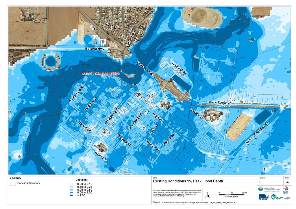
27 Town Levee: Existing 1% Flooding

28 Town Levee: 1% Impacts

29 Mitigation Options St Arnaud Road; Back St Arnaud Road; Railway line; Levees; Divert towards Yeungroon Creek; Improve flood warnings; Additional flood warning sites; Increase Avoca River capacity; Improve waterway management; Construct retarding basin/dam; Improve local drainage
30 Questions Feedback on the results Other suggestions for mitigation Website: refer to handout