Aquapath-Soil agricultural forecast service. Sustainable Agriculture and Land Use Pedro Chambel Leitão
|
|
|
- Silvia Holland
- 5 years ago
- Views:
Transcription
1 Aquapath-Soil agricultural forecast service Sustainable Agriculture and Land Use Pedro Chambel Leitão


2 Partners
3 What is MOHID and Why is important for Nexus? MOHID is an integrated system for water flow, consisting of two main modules: MOHID WATER for three-dimensional fluid dynamics and MOHID LAND for hydrology. MOHID allows for integration of different sources of data (local and EO) and models (meteo models, specific process models) generating information for Nexus decision
4 Where is the code? The latest source code of the model can be downloaded from Codeplex. Just click on the download link, no need to register. For advanced users you can download the entire solution ready to compile. angeset/view/62235# We also use other free source models like SWAT (swat.tamu.edu)


5 From data to society


6 LAI Aquapath-Soil


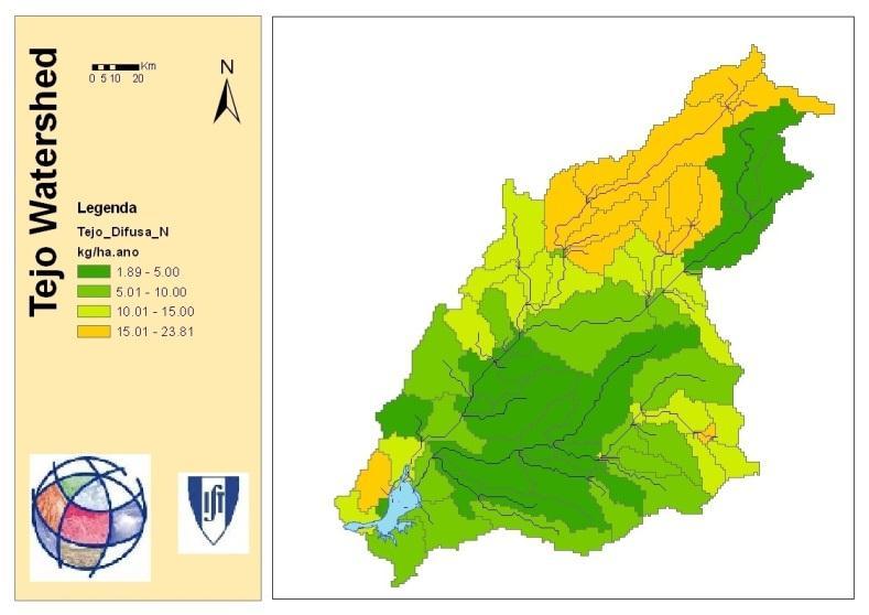
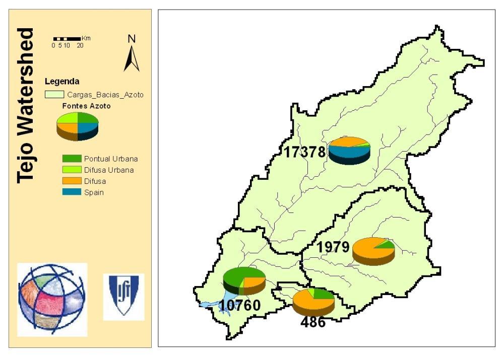

7 Aquapath GSE-LAND Land Use Diffuse Nitrogen Load Precipitation
8 Partners Delphi IMM EADS Astrium Finninsh Environment Institute Geoville Informationssysteme und Datenverarbeitung GmbH gim geographic information management H.G. Geo Data Solutions Gmbh Indra Espacio Infoterra Metria Planetek Italia S.r.l Tecnologías y Servicios Agrarios, S.A. IST-Maretec AUTH


9 LAI SenSyF
 Services o Implemented on top of common infrastructure o Currently 7")

10 Promoting Earth Observation Services SenSyF Project Overview IMPLEMENTATION CONCEPT Cloud-based infrastructure o Scalable o Based on ESA s G-POD Interface Layer o Data acquisition tools o Common data processing libs o Visualization web platform (Based on Glovisat) Services o Implemented on top of common infrastructure o Currently 7 services will support system development o S1: Monitoring of Continental Fresh Water, S2: Artic-Alpine Growing Season Map Service o S3: Soil Freezing/Thawing Product Service, S4: Spectro-Temporal Integration Service o S5: Multitemporal Land Cover Classification and Change Detection Service o S6: Agriculture Support Service, S7: Landscape Management Service


11 Promoting Earth Observation Services Partners and Roles DEIMOS: o Prime Contractor o To develop the interface layer (SenSyF SDK) and S6 Terradue: o To develop Cloud Infrastructure Framework Centro Nacional de Información Geográfica: o Development of S4 ACRI-ST: o Development of S1 Northern Research Institute: o Development of S2 and S3 Instituto Superior Técnico: o Development of S6 University of Valencia: o Development of S5 ARGANS Development of S7

12 LAI FIGARO


13 Soil moisture 1m 1m 1m


")
14 FIGARO Yield measured by harvester (GPS) NDVI by satellite

15 FIGARO Soil moisture: Mohid Land Versus Aquacrop versus measurments Aquacrop Mohid Land Measurments
16 Water - Energy The experimental field is located in Valley of Sorraia River. The field is a commercial farm.
17 Regulated deficit irrigation (RDI) from emergence to initial grain filling (waxy seed) RDI irrigation thresholds will be set at AWFC=0.75 and tension kpa= -70. From the initial grain filling (waxy seed) RDI irrigation thresholds are fixed at AWFC= 0.55 (-130 kpa).
 Israel AGORA P.S.V.D.")
 United Kingdom C-TECH INNOVATION LIMITED (C-Tech) United Kingdom THOMSEN ANTON GAARDE (AgroSens) DENMARK HIDROMOD MODELACAO EM ENGENHARIA LDA (Hidromod)")
18 Partners NETAFIM LTD (NETAFIM) Israel AGORA P.S.V.D. (Agora) Israel AARHUS UNIVERSITET (AU) Denmark HYDROLOGIC RESEARCH BV (HR) Netherland UNIVERSITAT POLITECNICA DE VALENCIA (UPVLC-IIAMA) Spain EDEN IRRIGATION CONSULTANCY LIMITED (Eden) United Kingdom C-TECH INNOVATION LIMITED (C-Tech) United Kingdom THOMSEN ANTON GAARDE (AgroSens) DENMARK HIDROMOD MODELACAO EM ENGENHARIA LDA (Hidromod) Portugal INSTITUTO SUPERIOR TECNICO (IST) Protugal ALMA MATER STUDIORUM-UNIVERSITA DI BOLOGNA (UNIBO) Italy CONSORZIO DI BONIFICA DI SECONDO GRADO PER IL CANALE EMILIANO ROMAGNOLO (CER) Italy TECHNION - ISRAEL INSTITUTE OF TECHNOLOGY (IIT) Israel DEMOCRITUS UNIVERSITY OF THRACE (DUT) Greece


19 LAI Land-Use Evapotranspiration Soil Moisture MyWater


20 Study sites, Partners and Users 2011/02/24 Page 20 2nd GMES Global Land workshop


21 Implementation Final review meeting

22 What next? Further integrate and upscale


23 Pan European Information


24 24 Maping products visualization


25 25

26 26


27 Managing coastal areas

28 Flooded areas
29 Conclusions What would improve your access and use of satellite Earth Observation data? Faster access to EO data ready to use (format, projection) More detail in time and higher resolution of EO data Global data sets How does your work contribute to a more integrated approach to natural resources management and use? Models integrate different sources of data Free source models can be used and improved by all How does your work inform planning and decisionmaking processes? Operational systems produce information