NAME. Introduction and background
|
|
|
- Ruby Wheeler
- 5 years ago
- Views:
Transcription
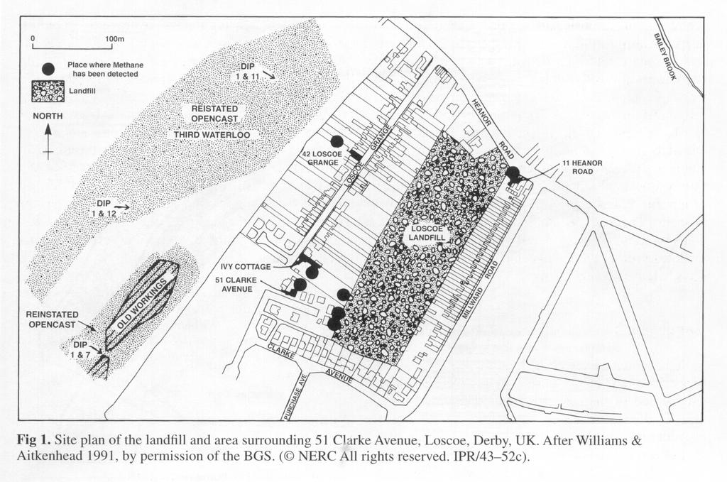
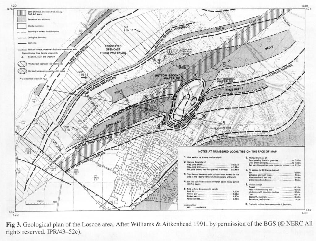
1 NAME FORENSIC GEOLOGY THE CASE OF THE EXPLODING BUNGALOW* Introduction and background At 06:30 on 24 March 1986 a bungalow at 51 Clarke Avenue, Losoce, some 16 km north of Derby, UK (see Fig. 1), was completely destroyed by an explosion when the central heating switched on automatically. The three occupants, although badly injured, were lucky to escape with their lives. The day itself was overcast and a very deep atmospheric depression passed over the area with an associated barometric pressure drop of 0.04 bar (4 kpa). Immediately after the explosion, gas samples were taken from the collapsed basement and were found to contain methane and carbon dioxide in ratios between 20-65% methane to 16-57% carbon dioxide. The bungalow is underlain by a sequence of coals, mudstones, siltstones and sandstones of Carboniferous age (Fig. 2). Most of the strata are impermeable, but the sandstones have an average porosity of 18-25% and a natural permeability of 600 md (millidarcy). The coal deposits have been worked commercially since 1885 by opencast, shallow and deep mining methods. The geological survey map of the area (1963) is shown in Figure 3 and a geological cross-section in Figure 4. Eight coal seams were worked from beneath the area from 1885 to the 1960s but this ceased when the shallowest seam was removed. Old records state that, in the oldest mines, naked flame lanterns were used for illumination. No deep shafts are recorded but some seams are so shallow that they may have been worked by drifts or adits to the northwest, where the rocks can be seen to dip regionally to the southwest. The majority of these shallow/surface workings have long become overgrown or reclaimed by agriculture. The working of one seam, the Roof Soil Seam, produced a zone of permanently extended or stretched strata as a result of the differential subsidence from below. This stretching increased the permeability of the rocks above (especially the sandstones), by the widening and extending of any pre-existing joints or fissures. The surface expression of this zone is shown in Figure 3. On top of the bedrock (beneath the topsoil) is a thin deposit of Pleistocene Head deposits. The soil itself consists of clay, silt and sand. Both sequences tend to behave impermeably. In some cases, house foundations and trenches for service ducts and pipes are cut to bedrock level ( m down). A number of wells and pumps are also shown on old maps. To the southeast of the bungalow, the Loscoe brick pit had been worked for brick clay, stone and coal from before A planning consent issued in 1966 stipulated that this void should be backfilled with agreed material, but the housing development was completed by 1973 when consent was given to deposit inert waste. In 1977 a waste disposal license was granted under the provision of the Control of Pollution Act (I974) to deposit 50 tons of domestic (putrescible) waste per day. This was in disregard of Government guidelines that stated that no houses should lie within 200 m of a landfill site. Dumping continued until 1982, and in 1984 the site was covered by permeable material. In 1985/6 the site was capped by a layer of impermeable clay to prevent water ingress and leachate production. This was effective as a positive pressure of 0.03 bar (3 kpa) was measured in the landfill during the drilling that took place subsequent to the explosion. Recent history In 1983 a pear tree in the garden of 51 Clarke Avenue began to die. Subsequently the soil became warm, dried out and crumbled. Other areas of the lawn died. Problems occurred after the lawn was -1-
2 returfed. Similar problems and unpleasant smells occurred in the garden of Ivy Cottage. At 42 Loscoe Grange, the occupier dug a hole 0.5m deep and an unpleasant sewer like smell was detected, together with a rumbling noise and a warm mould-like growth. The gas was below the lower explosive limit for methane and no carbon monoxide was recorded. British Coal was contacted and installed a standpipe with a flame trap to allow the gas to vent harmlessly to the atmosphere. Gas analysis indicated 35% methane and 65% carbon dioxide. In 1983 smells were reported at 13a Heanor Road (Fig. 1), but no methane was detected. In 1984, smells and low concentrations of methane were detected at 14 Clarke Avenue. Investigations by the Fast Midlands Gas Board suggested that it was not mains gas because carbon dioxide levels were too high and ethane (normally present in mains gas at 3% by volume, with a methane/ethane ratio of about 25: 1) was not recorded. Traces of methane and carbon dioxide were also detected at Purchase Avenue in 1985 and Initially, this soil heating and distressed vegetation was thought to be some sort of underground fire (perhaps a burning coal seam), but carbon monoxide levels, usually associated with coal burning in a limited supply of oxygen, were low. A bore-hole at Ivy Cottage showed a decrease in soil o o temperature with depth from 21 C at depths of m below ground level (bgl) to 18 C at 2.27 m bgl. This was accompanied by an increase in methane composition from 2% at the surface to 33.4% at 2.27 m bgl. Gas samples taken at 1.65 m bg1 in a sandstone contained 29.6% nitrogen. At 42 Ioscoe Grange, gas at 3.0 m bgl in a sandstone horizon contained 58% methane and 39% carbon dioxide. In the distressed soil areas the soil bacterium Pseudomonas methanica was identified. This has an affinity for methane and oxidizes it exothermically, with the production of water vapor and carbon dioxide. The heat causes net water loss and desiccation causes shrinkage and cracking at the surface, giving a direct route for methane venting. Determining the gas component A useful way of determining landfill methane (modern source) from the Coal Measures (ancient I4 source) is to determine its C content. Methane produced by the biodegration of recent organic waste 14 material, paper, wood, garden refuse, sewage etc. reflects an amount of C that is related to the 14 present. relatively high concentration in the atmosphere, while C from ancient geological sources has long since decayed away. (See Tables 1 & 2) The methane separated from the carbon dioxide at the standpipe at Loscoe Grange contained 14 significant quantities of C. The problem You are required to solve the problem by formulating multiple hypotheses, some of which may be discounted sooner than others. The following questions will help you to do this. 1. What caused the explosion? Coal gas? Landfill gas? Ordinance? Natural gas? Marsh gas? Meteorite impact? Mains Sewer gas? Terrorist outrage? Does the gas responsible have a component that is specific (unique) to its particular source? 2. Can a permeability pathway be established from the suspected origin of the gas to the bungalow (Use the maps and cross-section) 3. Can a driving force be established to allow the gas to move from its origin to the bungalow? (A diffusion or pressure gradient is needed) Note: Diffusion is unlikely, as calculations based on diffusion rates through a porous medium suggest an interval of 23 years to achieve a 5% methane content by movement through 90 m of sandstone. How long would it take to achieve a source composition of 60% methane and 40% carbon dioxide sampled at the bungalow. 4. What ignited the gas? 5. What evidence suggests the underlying, coal seams were not gassy? 6. What are the explosive limits for methane? 7. Why was a mains gas explosion discounted? -2-
3 8. What is the source of the nitrogen in the bore-hole at Ivy Cottage? 9. Why could a burning coal seam be discounted? 10. Why should the local ground hotspots be episodic? Now present your case, stating who/what is to blame for the explosion. What, as a forensic geoscientist, would you suggest were the lessons learned from this case? *Case taken from Lee, C. W. (2004) The nature of, and approaches to, teaching forensic geoscience in forensic science and earth science courses. Pye, K. & Croft, D.J. (eds.) Forensic Geoscience: Principles, Techniques and Applications. Geological Society of London, Special Publications, 232,
4 -4-
5 -5-
6 -6-
7 -7-