Our Ref: MJ: L.M doc. 5 May TGM Group Level 1, Myers Street, PO Box 1137 Geelong Vic Attention: Chris Marshall.
|
|
|
- Dwight Richards
- 5 years ago
- Views:
Transcription

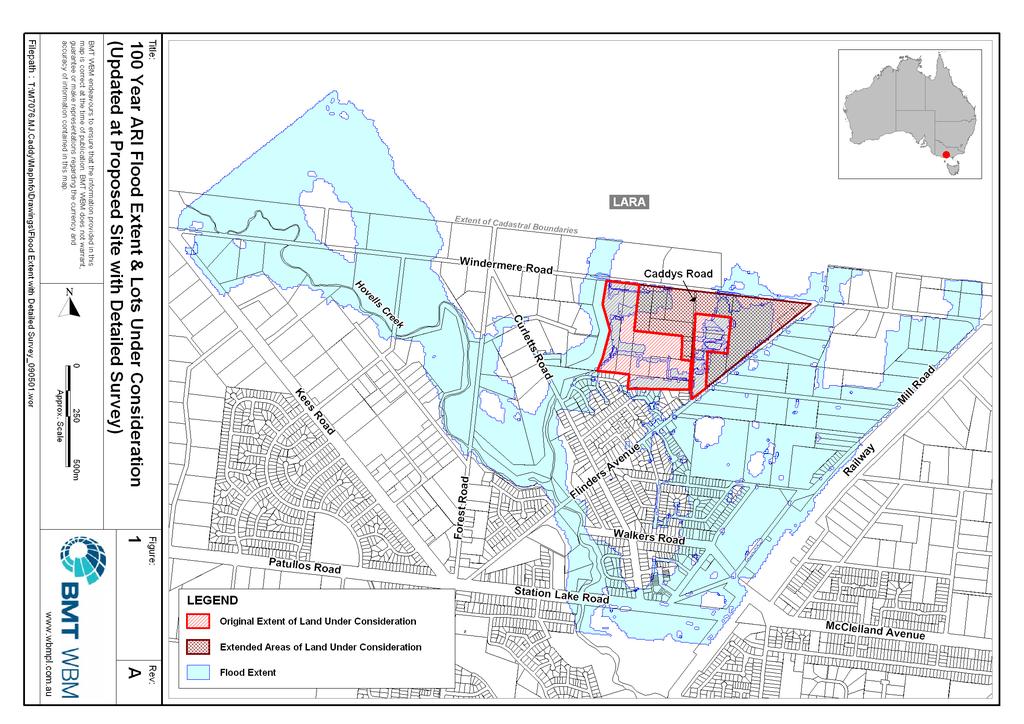
1 BMT WBM Pty Ltd Level 5, 99 King Street MELBOURNE VIC 3000 Australia PO Box 604 Collins Street West VIC 8007 Tel: Fax: ABN Our Ref: MJ: L.M doc 5 May 2009 TGM Group Level 1, Myers Street, PO Box 1137 Geelong Vic Attention: Chris Marshall Dear Chris RE: PROPOSED DEVELOPMENT AT CADDY'S ROAD - DRAINAGE ASSESSMENT UPDATE In 2007 BMT WBM was retained by L Bisinella Developments Pty Ltd to provide expert drainage evidence to the planning panel hearing into Amendment C123 of the Greater Geelong Planning Scheme. BMT WBM prepared a drainage report (R.M Expert Report - copy attached) identifying constraints and opportunities for land located to either side of Caddys Road and bounded by Windermere Road, Serendip Creek and Flinders Ave. L Bisinella Developments is now considering development of an expanded parcel of land and is applying for rezoning under the Planning Scheme Amendment C73. Figure 1 shows the original development area and the extended area under consideration. BMT WBM has reviewed our earlier report and the proposed additional land and has prepared the following preliminary advice in relation to drainage of the larger area. Figure 1 shows that portions of the extended area are, like the original area, subject to inundation in a 100 year ARI event. The inundation is from both the local catchment and from the catchment to the north of Windermere Road. The floodwater is shallow with the depth being less than 5 cm. A solution proposed in the earlier report involved increasing the capacity of the table drain in Windermere Road such that it captured all flow that would currently cross Windermere Road and enter the subject site in a 100 year ARI flood event. Given that flooding in the extended area is in part caused by overflow from Windermere Road, the extended area would also benefit from the table drain upgrade without any additional works from those originally proposed. The management of local runoff from the site and from surrounding lots (now the extended area) was also considered in the earlier report. All runoff from the site itself was directed to Serendip Creek and it was noted that stormwater connections to adjacent lots would be required. The proposed inclusion of the surrounding lots will allow for a more easily integrated stormwater management design, for both quantity and quality. The earlier report noted For future detailed analysis, it is also recommended that a review of the resolution of the portion of the hydrological model to the north of Windermere Road be undertaken to ensure the upgraded table drain is appropriately sized. This additional analysis would still be required. The earlier report also noted that this combination of measures showed no adverse impact on flood levels and would provide benefit to the broader community by alleviating flooding in area to the south. The inclusion of the extended area does not alter this conclusion. T:\M7076.MJ.Caddy\L.M doc A part of BMT in Energy and Environment
2 In summary the original report recognised that development of the extended area may occur and took this into consideration when proposing a solution for this site. The inclusion of the extended area will allow for more easily integrated stormwater management of the site. Therefore it is concluded that drainage does not represent a constraint to the development and would provide a flood benefit to the existing development to the south. Yours faithfully BMT WBM Pty Ltd Dr Mark Jempson Manager Water & Environment Victoria T:\M7076.MJ.Caddy\L.M doc
3
4 Caddys Road Development Drainage Assessment Report Prepared For: Prepared By: Bisinella Developments Pty Ltd WBM Pty Ltd (Member of the BMT group of companies) Offices Brisbane Denver Karratha Melbourne Morwell Newcastle Perth Sydney Vancouver
5 DOCUMENT CONTROL SHEET WBM Pty Ltd Melbourne Office: Level 5, 99 King Street MELBOURNE VIC 3000 Australia PO Box 604 Collins Street West VIC 8007 Telephone (03) Facsimile (03) ABN Document : Project Manager : Client : Client Contact: Client Reference R.M Expert Report.doc Mark Jempson Bisinella Developments Pty Ltd C/ Phil Bisset, Minter Ellison Lawyers Title : Author : Synopsis : Caddys Road Development Drainage Assessment Report Dr Mark Jempson Report detailing the hydraulic modelling and impact assessment of the proposed Caddys Road development at Lara. REVISION/CHECKING HISTORY REVISION NUMBER DATE OF ISSUE CHECKED BY ISSUED BY 0 23/2/07 TC MJ DISTRIBUTION DESTINATION Bisinella Developments Pty Ltd Minter Ellison TGM Group WBM File WBM Library REVISION
6 0BCONTENTS I CONTENTS Contents List of Figures i i 1 INTRODUCTION AVAILABLE DATA CONSTRAINTS & OPPORTUNITIES Constraints Opportunities HYDRAULIC MODELLING Existing Case Developed Case Impact Assessment Alternative Development Scenario SUMMARY REFERENCES 6-1 LIST OF FIGURES Figure 1-1 Locality Plan 1-2 Figure Year ARI Flood Extent from WBM (2002) 3-2 Figure 4-1 Impacts of Proposed Development on 100 year ARI Flood Levels Serendip Model Extents 4-3 Figure 4-2 Impacts of Proposed Development on 100 Year ARI Flood Levels Site and Surrounds 4-4
7 2BINTRODUCTION INTRODUCTION L Bisinella Developments Pty Ltd is objecting to Amendment C123 of the Greater Geelong Planning Scheme. Amendment C123 is designed to reflect the Lara Structure Plan as adopted by the Greater Geelong City Council in June There are a number of grounds of objection, but the key objection in the context of this report is to the exclusion of land around Caddys Road from the areas suitable for future residential development. The land under consideration lies within the Serendip Creek and Hovells Creek catchments. The land is located to either side of Caddys Road and is bounded by Windermere Road, Serendip Creek and Flinders Ave, as shown in Figure 1-1. Hydraulic modelling of the catchments was undertaken by WBM Pty Ltd for the City of Greater Geelong (CoGG) in January 2002 as part of the Lara Flood Study. Details of this study can be found in the Lara Flood Study Stage 1 Report (WBM, 2002). The site is located within the Serendip TUFLOW model developed for this study. WBM was retained to provide expert drainage evidence to the panel hearing. Specifically WBM was to provide advice on possible constraints to development on the site and to identify solutions to constraints. The analysis was undertaken using the Serendip TUFLOW model. Dr Mark Jempson who has been an employee of WBM Pty Ltd since January 1999 prepared this statement. Mark is an Associate at WBM, and has been the Manager of the Water and Environment Group in Melbourne since January Prior to January 2003 Mark was a Senior Hydraulics Engineer in WBM s Brisbane office. Mark s qualifications include a Bachelor of Engineering (Civil) degree from the Queensland University of Technology, and Master of Engineering Science and Doctorate of Philosophy degrees from the University of Queensland. The degrees at the University of Queensland were undertaken through the Department of Civil Engineering and focussed on hydraulic engineering and fluid mechanics. Mark has 18 years experience as an engineer, 16 of these in the field of hydrology and hydraulics. Mark s areas of expertise include hydrologic and hydraulic modelling of rural and urban catchments. Mark has undertaken analyses on over 80 catchments throughout Victoria, New South Wales and Queensland. WBM hydraulics engineer Talia Campbell undertook some aspects of this investigation such as model modifications and analysis. In preparing the attached report Mark Jempson reviewed the following documents: Relevant sections of the Brief of Documents prepared by Minter Ellisons Lawyers the Lara Flood Study Stage 1 Report (WBM, 2002) The TGM group provided iterations of digital elevation models that represented proposed development layouts, including proposed modifications to a table drain running alongside Windemere Road.

8 2BINTRODUCTION 1-2 Figure 1-1 Locality Plan
9 3BAVAILABLE DATA AVAILABLE DATA The Serendip TUFLOW model provided the base data for the study. In addition to this, the following data was provided by TGM: detailed feature survey of the existing Caddys Road site; a Triangulated Irregular Network (TIN) representing proposed design surface levels of the proposed development; details of the proposed drainage pipe upgrades for the table drain along Windermere Road; peak 100 year ARI developed case flow rates from the development site.
10 4BCONSTRAINTS & OPPORTUNITIES CONSTRAINTS & OPPORTUNITIES 3.1 Constraints A review of the existing flood extents presented in WBM (2002) indicates that the portion of the land under consideration to the west of Caddys Road is largely flood free in the 1% AEP (100 year average recurrence interval) flood. The ground elevation falls approximately 5 m from Caddys Road to the edge of the property boundary along the waterway. This will provide sufficient slope for the design of the local drainage system. A significant portion of the land under consideration to the east of Caddys Road is inundated in the 1% AEP flood. However, the flow is shallow, being in the range 5 cm to 10 cm and should not represent a significant constraint. Flooding on this portion of the land is runoff from the north, including flow across Windermere Road. Filling of this land without suitable flow management would result in flood impacts on the land to the north and east. Although the ground slope of this portion is flatter than that to the west of Caddys Road, draining this part of the development across Caddys Road and down to the water will provide a fall of approximately 5.5 m, which will be adequate for the design of the stormwater pipe network. Consideration of the management of street flows in the 100 year ARI flood event will require careful management. 3.2 Opportunities A significant portion of the flooding on the land east of Caddys Road is from the catchment to the north of Windermere Road. A table drain currently runs along the southern side of Windermere Road through to Serendip Creek. The existing table drain would collect some of this flow, although this level of detail is not represented in the Serendip hydraulic model. The capacity of the table drain could be increased to capture all or most of this flow, thereby preventing most of the flow across the land to the east of Caddys Road. It is shown in this report that this will ease existing flooding problems to the south of the developemnt, thereby providing a benefit to the wider community. The development of the land under consideration will not constrain development of adjacent land. The provision of stormwater connections and overland flow paths could be accommodated. The provision of connections would simplify the development of these adjacent blocks.
")
11 4BCONSTRAINTS & OPPORTUNITIES Figure Year ARI Flood Extent from WBM (2002) 3-2
12 5BHYDRAULIC MODELLING HYDRAULIC MODELLING The Serendip TUFLOW hydraulic model was adopted for this analysis. The model was used to assess the impact of the proposed development on flood levels. As detailed below, some changes were made to the base (existing) case model to improve the level of detail in the model for the purposes of this localised assessment. Once the existing case model was established and run, the model was altered to include a representation of a preliminary design option. The flood levels from this developed case model were then compared to those from the existing case model to identify significant changes in flood level. 4.1 Existing Case The following changes were made to the Serendip TUFLOW Existing Case model to provide an improved level of detail in the vicinity of the proposed development. Ground level information was updated using the detailed feature survey undertaken by TGM. The feature survey covered the proposed development site and properties to the east of the proposed development. A comparison with the ground level data used in the original model to that from the recent survey indicated a good match, with variations of typically of the order of 2 cm to 5 cm. The most significant change in the context of this report was the representation in the model of the table drain running along Windermere Road. This level of detail was not required in the original model, but given the opportunity identified for upgrading this drain, its inclusion in the existing case model was required. Other features of the drain including details of the drainage pipes beneath the Windermere Road Caddys Road intersection and the driveways on the southern side of Windermere Road were included. The local distribution of runoff in the vicinity of the land under consideration was adjusted in the existing case model to allow representation of runoff from the subject land. This was required so that flows in the developed case assessment could be reliably represented. For future detailed analysis, it is also recommended that a review of the resolution of the portion of the hydrological model to the north of Windermere Road be undertaken to ensure the upgraded table drain is appropriately sized. The Existing Case model was run for the 100 year ARI event. There was no significant change from the results presented in WBM (2002), apart from flow down the existing table drain and some overflow from this drain onto properties to the west of Caddys Road. 4.2 Developed Case Details of the proposed development were incorporated into the TUFLOW model. These details included proposed changes to the site ground elevations and proposed changes to the table drain and drainage pipes along Windermere Road. The runoff from the site was also increased to represent the increase in flow expected from the developed site. Residential development was assumed over the full area, except for a 200 m buffer to the south of Windermere Road. Details for
13 5BHYDRAULIC MODELLING 4-2 these changes were provide to WBM by TGM. No internal stormwater pipe network was included in the modelling for this report. The Developed Case model was run for the 100 year ARI design event. 4.3 Impact Assessment The predicted peak water surface elevations from the Existing and Developed Case models were compared to assess the impacts of the proposed development. Figure 4-1 presents the impacts across the extents of the Serendip TUFLOW model. Figure 4-2 shows the impacts within the site and on the surrounding properties. In these figures the yellow colour indicates no change in flood level as a result of the development within a tolerance of 3 cm, green shades indicate reductions in flood level and brown/red shades indicate areas with increased flood level. The pink shade indicates areas that would no longer flood should the development proceed and the blue indicates areas that were dry and would now be inundated. The results presented in the figures indicate that the proposal would have no significant impact external to the site. The analysis indicates that, if the development were to proceed, existing flooding to the south would be alleviated (the pink shading in the figures). This occurs because runoff from the site is directed across to Serendip Creek rather than flowing to the south, and also the increased capacity of the table drain along Windermere Road reduces the flow into this area. 4.4 Alternative Development Scenario WBM was also briefed to provide advice on the impacts of a development scenario that included development up to Windermere Road, ie, a scenario in which there was no 200 m buffer. The development of this additional area would increase the impervious area and hence runoff, but the increase would be minor and will not significantly alter flood levels external to the site. Developing in the buffer area may also impede an existing overland flow path, but this could be easily managed using stormwater pipes and/or a defined overland flowpath through the development.

14 5BHYDRAULIC MODELLING Figure 4-1 Impacts of Proposed Development on 100 year ARI Flood Levels Serendip Model Extents 4-3

15 5BHYDRAULIC MODELLING 4-4 Figure 4-2 Impacts of Proposed Development on 100 Year ARI Flood Levels Site and Surrounds
16 6BSUMMARY SUMMARY The Serendip TUFLOW model developed by WBM for the City of Greater Geelong was used to assess the impacts of developing land under consideration at Caddys Road Lara. Minor modifications were made to the model to better represent the existing flooding patterns in and around the land under consideration. The model was then modified to represent a conceptual development of the site. The capacity of an existing table drain along Windermere Road was increased to capture all flow that would currently cross Windermere Road and enter the subject site in a 100 year ARI flood event. All flow runoff from the site itself was directed to Serendip Creek. This combination of measures showed no adverse impact on flood levels and would provide benefit to the broader community by alleviating flooding in area to the south. Consideration was given to an alternative development scenario without a 200 m buffer to Windermere Road. Because of only minor changes in the runoff, it is expected that the impacts would not vary significantly from those presented for the modelled scenario. Therefore drainage is not considered to be a constraint. From this initial assessment it is concluded that drainage does not represent a constraint to development of the land under consideration and that it would provide a flood benefit to an area to the south. Stormwater connections to adjacent land could be provided so that the development of the land does constrain development of the adjacent land.
17 7BREFERENCES REFERENCES WBM Pty Ltd (2002), Lara Flood Study Stage 1, Report prepared by WBM Pty Ltd for the City of Greater Geelong, Report No. R.W FINALREPORT.DOC, February 2002.