Mohamed Mostafa Mohamed. Civil and Environmental Engineering Department United Arab Emirates University
|
|
|
- Scott White
- 5 years ago
- Views:
Transcription


1 Mohamed Mostafa Mohamed Civil and Environmental Engineering Department United Arab Emirates University
. Low groundwater recharge rate and no reliable surface water resources Groundwater is the only conventional source with about 80% share.")
2 UAE occupies an area of about 85,000 km² Water demand is 26 times renewable resources The Emirate has an arid climate with less than 00 mm/yr average rainfall, a very high evaporation rate (2-3m/yr). Low groundwater recharge rate and no reliable surface water resources Groundwater is the only conventional source with about 80% share.


3

4 The UAE is listed by the United Nations as a high-rank country when it comes to water stress, a situation which occurs when the availability of water is not in balance with the demand for water


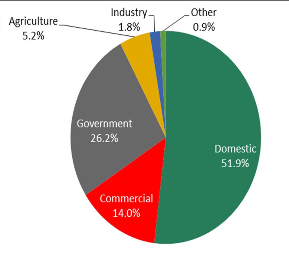
5 In 203, the water demand was estimated as 5,400 MCM with annual growth of about 0% 79 % Groundwater 7 % Desalination 4 % Treated Sewage 2007


6

7 64km3 groundwater resources available in AD, mostly non-renewable, less than 3% is fresh Based on current abstraction rates, both fresh and brackish reserves will be depleted within 50 years Abu Dhabi groundwater intake has been decreasing at annual rate of 6%.


8 World's second largest producer of desalinated water
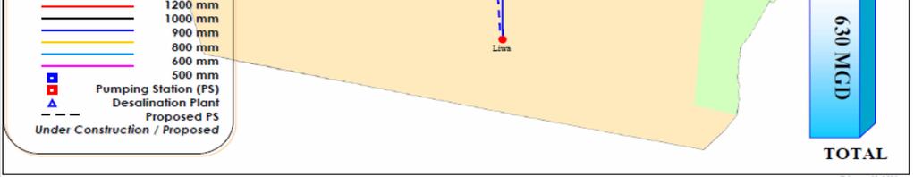
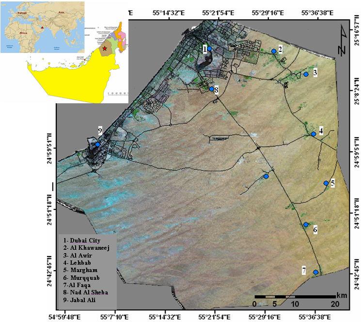
9 The water desalination plants are the only source of drinking water The water is delivered by TRANSCO from: Taweelah through twin,200 mm diameter pipelines, with boosting provided at pumping stations at Ajban and Sweihan; Abu Dhabi through a,000 mm diameter pipeline boosted at the Shobaisi and Remah pumping stations; and Fujairah via twin,600 mm diameter pipelines 3,900 km of pipelines, from 80 mm to 800 mm diameter 8 pumping stations The average supply to Alain 293 MCM per year


10 203 MCM


11 Dawoud, 2005


12 Bulk per capita water consumption in Abu Dhabi Emirate and some developed countries (data for developed countries were adopted from Conference Board of Canada (2008)).


13 Domestic per capita water consumption in selected countries (EAD, 2007)
 Mm3/year.0 00 42.4 49 5.5 2.9 35.5 354.9 75 0.8 75.")
14 Components INFLOW GWI P IR TSEIR R L DWP Total Input OUTFLOW ET GWO Total Output Balance Water use patterns in eastern UAE (Mohamed et al., 203) Mm3/year

15 ~ 55 Mm3/year of sewage water generated annually in AlAin ~200 Mm3/year of sewage water generated annually in Dubai ~200 Mm3/year of sewage water generated annually in Abu Dhabi
16 Enhance National Strategic Groundwater Reserves via Managed Aquifer Recharge with Recycled Water


17


18
19 SWS, 200

 injection")

20 The seven elements common in MAR systems (a) injection wells, and (b) infiltration basins (Pyne 2005)

21 Physical storage increase amount of water in storage in an aquifer. Chemically bounded injected freshwater displaces water of lesser quality. Regulatory storage (water banking) injection confers the right to later withdrawal water. SWS, 200
22 Feasibility study (current project) Exploratory program Pilot MAR study Full-scale MAR implementation Maintenance and adaptive management

23 Study area Study area 2
24 Several meeting were conducted with delegates from: Ministry of Environment and water Al-Ain distribution company National Drilling company Al-Ain municipality Abu Dhabi Sewerage Services Company Environmental Agency of Abu Dhabi
25 Depth to GW GW Aquifer Hydraulic Conductivity Soil Type Land Surface Topography Impact of Vadose Zone Land Surface Slopes Land Use Distribution Distance from source
26 Parameter Geology Slope Ranks Influence for identifying artificial recharge sites 5 Very good 4 Good 3 Moderate to Good 2 Moderate Poor Class Rank Gravel Plain Desert Plain Fluviatile Sediments Sand Dunes Limestone and Marl 0 o 3o 3 7o 7 5 o > 5 o Pediment zones 4.75 Structural hills 4 Desert 3 Inter-dune Areas Wt. Parameter Rank Wt. 30 mm 00 mm 2 70 mm mm < < 0 mm < Gravel Coarse Sand Fine Sand Silt Rock Alluvial Gravels 5 3 Fluviatile sandy soil Brown Soils (Desert Sands) Fine sand - Silt 3 Mountains Hills (Bare Bedrock) Plateau <6m 6. 2 m m m 4 Buildup Area Agriculture Rangelands and Grazing lands Forestry and wooded parklands > 24 m 5 No Vegetation - Rocks Rainfall Storativity 3.5 Soil Morphology Water Level Class 6 Land Use


27 55 0'0"E 55 20'0"E 55 40'0"E 56 0'0"E 24 40'0"N 24 40'0"N 24 20'0"N 24 20'0"N Mixed Sed. Sand Dunes Fluviatile Processing 24 0'0"N 24 0'0"N Gravel Plains 55 0'0"E 55 20'0"E 55 40'0"E 56 0'0"E


28 55 0'0"E 55 20'0"E 55 40'0"E 56 0'0"E 24 40'0"N 24 40'0"N 24 20'0"N 24 20'0"N High Conduc. 24 0'0"N 24 0'0"N Processing 55 0'0"E 55 20'0"E 55 40'0"E 56 0'0"E Low Conduc.


29 55 0'0"E 55 20'0"E 55 40'0"E 56 0'0"E 24 40'0"N 24 40'0"N 24 20'0"N 24 20'0"N Fine Soils 24 0'0"N 24 0'0"N Processing Coarse Soils 55 0'0"E 55 20'0"E 55 40'0"E 56 0'0"E


30 water saturation, capillary pressure, relative permeability, hydraulic conductivity, effective porosity


31 55 0'0"E 55 20'0"E 55 40'0"E 56 0'0"E 24 40'0"N 24 40'0"N 24 20'0"N 24 20'0"N Low Depth Processing 24 0'0"N 24 0'0"N 55 0'0"E 55 20'0"E 55 40'0"E 56 0'0"E High Depth


32 55 0'0"E 55 20'0"E 55 40'0"E 56 0'0"E 24 40'0"N 24 40'0"N 24 20'0"N 24 20'0"N Low Impact 24 0'0"N 24 0'0"N Processing High Impact 55 0'0"E 55 20'0"E 55 40'0"E 56 0'0"E


33 Processing
34 Parameter Geology Slope Ranks Influence for identifying artificial recharge sites 5 Very good 4 Good 3 Moderate to Good 2 Moderate Poor Class Rank Gravel Plain Desert Plain Fluviatile Sediments Sand Dunes Limestone and Marl 0 o 3o 3 7o 7 5 o > 5 o Pediment zones 4.75 Structural hills 4 Desert 3 Inter-dune Areas Wt. Parameter Rank Wt. 30 mm 00 mm 2 70 mm mm < < 0 mm < Gravel Coarse Sand Fine Sand Silt Rock Alluvial Gravels 5 3 Fluviatile sandy soil Brown Soils (Desert Sands) Fine sand - Silt 3 Mountains Hills (Bare Bedrock) Plateau <6m 6. 2 m m m 4 Buildup Area Agriculture Rangelands and Grazing lands Forestry and wooded parklands > 24 m 5 No Vegetation - Rocks Rainfall Storativity 3.5 Soil Morphology Water Level Class 6 Land Use

35
36 Feasibility study (current project) Exploratory program (2nd phase) Pilot MAR study (3rd phase) Full-scale MAR implementation Maintenance and adaptive management


37


38


39

40


41 Hydraulic Boundary: No Flow Physical Boundary: Oman Mountains Hydraulic Boundary: Constant Head Hydraulic Boundary: No Flow


42
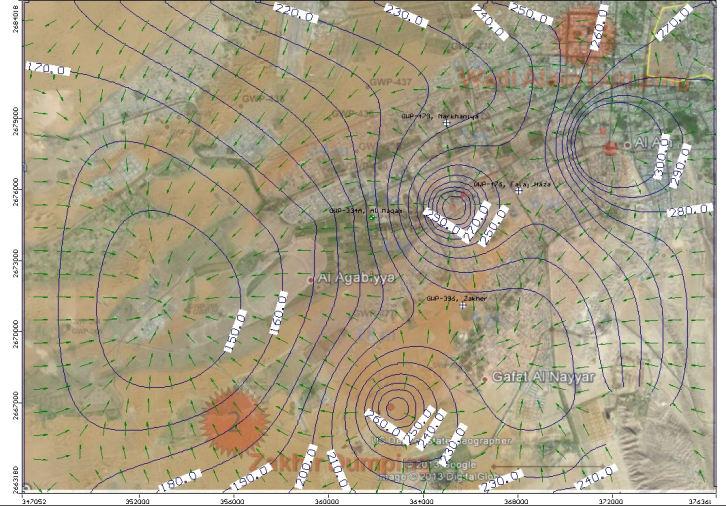
 240 280 300")
 0.73.42 0.")
43 Observation location Al Maqam Al Jaww Near Hafeet Observed Head(m) Simulated Head(m) Head Difference (m) Error %

44 After 5 years After 20 years
45 Feasibility study (current project) Exploratory program (2nd phase) Pilot MAR study (3rd phase) Full-scale MAR implementation Maintenance and adaptive management
46 Currently, about 50% of sewage water generated is diffused after purification. If this water is wisely recharged into groundwater aquifers, it can help building a back-up reservoir to face potential threats of shortage in freshwater supply in emergency cases. Ultimately, upon completion, this project could lead to replenishing the aquifers with 25 and 00 MCM of TSE water generated annually in Al-Ain and Dubai. The advantages of ASR are compelling very large volumes of water can be stored underground at a fraction of the cost of other storage options. However, Inadequate aquifer characterization can cause the ASR system to fail.
47 Thank You