Proposed plan for the Joslyn Manufacturing Company Superfund Site
|
|
|
- Adrian Hines
- 5 years ago
- Views:
Transcription

1 Proposed plan for the Joslyn Manufacturing Company Superfund Site March 2017
2 Authors Andri Dahlmeier Hans Neve Contributors/acknowledgements Walker Smith Frederick Campbell Steven Schoff Al Timm The MPCA is reducing printing and mailing costs by using the Internet to distribute reports and information to wider audience. Visit our website for more information. MPCA reports are printed on 100% postconsumer recycled content paper manufactured without chlorine or chlorine derivatives. Editing Sherry Mottonen 520 Lafayette Road North Saint Paul, MN Or use your preferred relay service. This report is available in alternative formats upon request, and online at Document number: g-27-03e
3
4 Contents Contents... i 1.0 Statement of purpose Site location Joslyn Site history History of Middle Twin Lake History of the West Area and Southern Lots (OU5) OU5 investigations and site characteristics Human health and ecological risks from the West Area (OU5) Evaluating soil exposure pathways Risk-based soil criteria Remedial alternatives Regulatory classification of OU5 soils Flood plain and wetland considerations Stormwater Management Evaluation of proposed cleanup alternatives Summary of remedial alternatives Summary of the preferred alternative Public input i
5
6 1.0 Statement of purpose The purpose of this Proposed Plan is to solicit public comment on a proposed cleanup action for Operable Unit 5 (OU5) of the Joslyn Manufacturing & Supply Company Superfund Site (the Site). This Proposed Plan will provide background information of the Site, describe various cleanup alternatives, identify the s (MPCA s) preferred cleanup alternative, and provide an opportunity for public comment on the preferred alternative. The MPCA is the lead agency at the Site. MPCA will select a final remedy for the Site after considering all written comments submitted during a 30-day public comment period. The public comment period runs from March 27, 2017 to May 5, MPCA encourages the public to review and comment on this Proposed Plan. MPCA also encourages community members to attend and participate in an open house and public meeting at the Hennepin County Library, Brookdale Room ABC, located at 6125 Shingle Creek Parkway in Brooklyn Center, Minnesota 55430, on April 12, The public meeting begins with an open house at 5:30 p.m., and a short formal presentation at 7:00 p.m. MPCA s decision on the final remedy for the Site will be announced in local newspaper notices and on the MPCA website, and presented in a document called a Record of Decision (ROD). The ROD will include a Responsiveness Summary that summarizes MPCA s responses to public comments on this Proposed Plan. MPCA may modify the preferred alternative or select another response action presented in this Proposed Plan based on new information or public comments. Therefore, the public is encouraged to review and comment on all the alternatives presented in this Proposed Plan. The implementation of this Proposed Plan will result in the long-term protection of public health and the environment, comply with regulatory requirements, and address other issues posed by the contaminated soils at OU5. This Proposed Plan meets the requirements for remedy selection under the state Superfund law (Minnesota Environmental Response and Liability Act or MERLA) and presents a remedy that is consistent with the requirements of the federal Superfund law (Comprehensive Environmental Response, Compensation, and Liability Act or CERCLA). This Proposed Plan is based on information from the Focused Feasibility Study REVISION 3, Operable Unit 5 West Area Soils, Joslyn Manufacturing & Supply Co. Site, Brooklyn Center, Minnesota (Feasibility Study) completed by Barr Engineering Company in January 2017 on behalf of Joslyn Manufacturing Company (Joslyn), the responsible party. The Feasibility Study contains detailed information about the evaluated alternatives including the proposed alternative. 2.0 Site location The Site is located in Brooklyn Center, northwest of the intersection of Azelia Avenue North and Lakebreeze Avenue North, and is bounded on the west by Middle Twin Lake, on the north by railroad tracks and open space, and on the south by a residential neighborhood (Figure 1). OU5 consists of the West Area, the westernmost portion of the Site, and two undeveloped residential lots owned by Joslyn, referred to as the Southern Lots. The Southern Lots adjoin the Site to the south of the West Area. The West Area (shown in yellow on Figure 2) is located between a portion of the Site that has been remediated and redeveloped (shown in blue on Figure 2) and Middle Twin Lake. 1
7 3.0 Joslyn Site history From the 1920s until 1980, a succession of companies treated wooden poles and ties at the Site. The wood preservatives used at the Site included creosote, pentachlorophenol (PCP) and copper-chromium arsenate. Soil, sediment, and groundwater at the Site became contaminated with PCP and polynuclear aromatic hydrocarbons (PAHs), a constituent of PCP. As a result, Joslyn undertook the investigation and remediation of the Site as the responsible party, as determined by MPCA in The Site was listed on the federal National Priorities List (NPL) in 1984 and the state Superfund list referred to as the Permanent List of Priorities (PLP) in In 1988, after completing a remedial investigation, an interim response action resulted in the off-site disposal of heavily contaminated soils and wood-treating fluids. In 1989, following public comment, MPCA issued a ROD for the Site that documented the selected remedial actions. Distinct elements of the remedial actions are described using the term operable unit (OU). For groundwater (OU1 and OU2), the selected remedy includes groundwater pumpout and long-term groundwater monitoring. A recovery system was selected for collecting waste wood-treating chemicals, which are present in the aquifer as dense non-aqueous phase liquid (DNAPL), (OU3). For the remaining contaminated soil (OU4), the remedial actions included on-site biological treatment. It was later discovered that portions of the Site were contaminated by polychlorinated dibenzo-p-dioxins and furans (dioxins), which are impurities of the wood preservative PCP. OU1 and OU2: Groundwater Since 1989, groundwater pumpout wells have been removing contaminated groundwater from the upper aquifer (OU1 and OU2), thereby controlling lateral and vertical migration of contaminants. As verified by routine monitoring and data analysis, the remedial actions have successfully contained contaminated groundwater within the upper aquifer at the site s downgradient (eastern) boundary and have prevented downward migration of contaminants. OU3: DNAPL A recovery system was installed in 1996 to recover the waste wood-treating chemicals (DNAPL). To date, approximately 16,700 gallons of DNAPL have been recovered and sent off-site to a permitted facility and incinerated. This remedial action will continue until the recoverable DNAPL has been removed from the aquifer. OU4: Contaminated soil OU 4 consisted of the visually contaminated soil remaining on the Site after the 1988 interim response action. The remedy for OU4 included the excavation and on-site treatment of these soils through biological degradation of contaminants. The ROD also allowed the off-site disposal of soils that could not be treated on-site. From 1989 through 1998, approximately 85,000 cubic yards of contaminated soil were remediated onsite. Contaminated soils left on-site were capped by buildings, and in other areas, a clean soil layer. Restrictive covenants were placed on the Site to ensure the remedy remains effective. In 1999, Joslyn sold a portion of the Site to a redevelopment company called Real Estate Recycling (RER), a redevelopment company specializing in contaminated properties. RER also purchased land adjacent to the Site that eventually led to the construction of three new buildings on and adjacent to the Site. The redevelopment was possible through the cooperative efforts of Joslyn, RER, the City of Brooklyn Center, 2
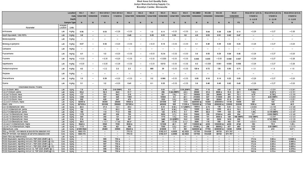
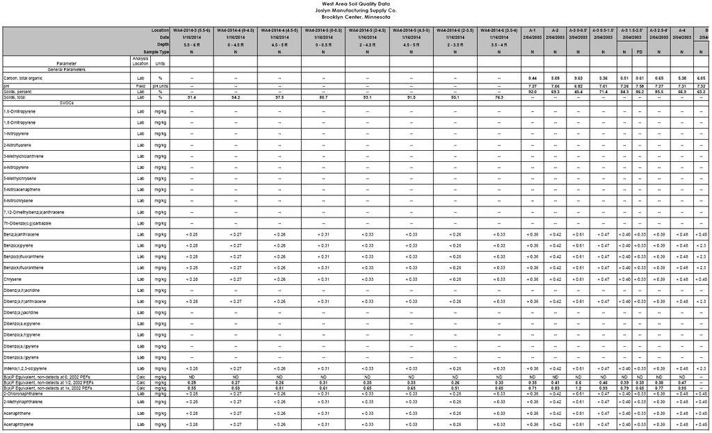
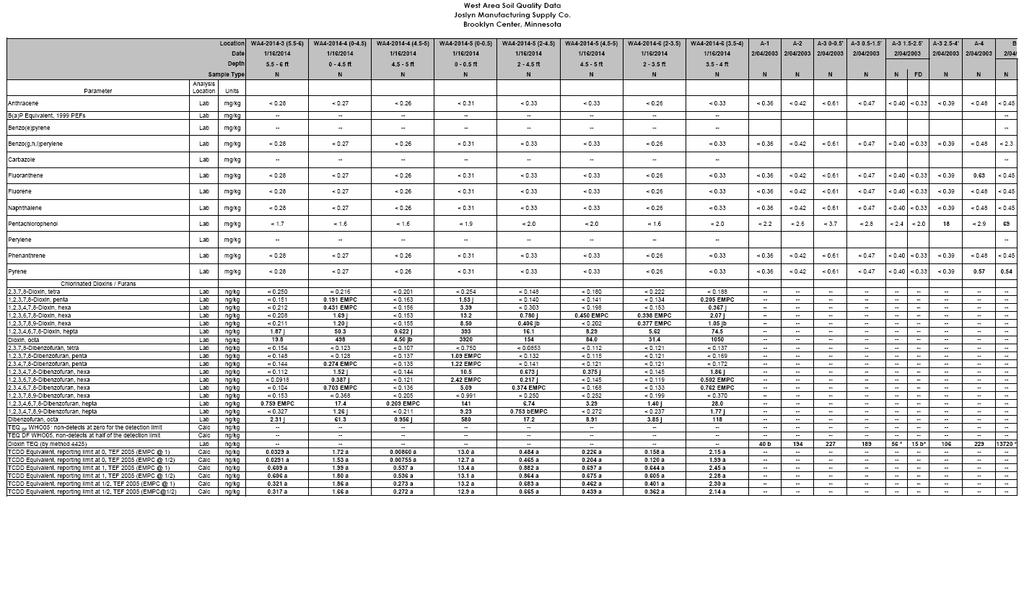
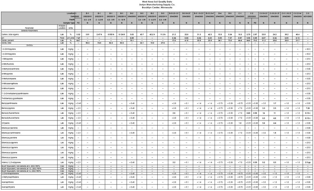
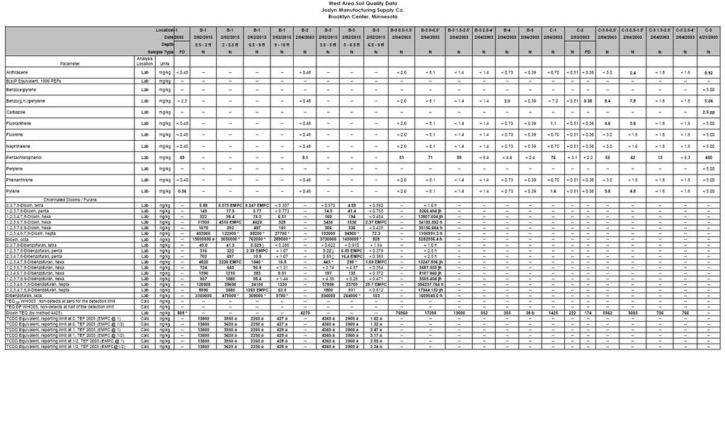
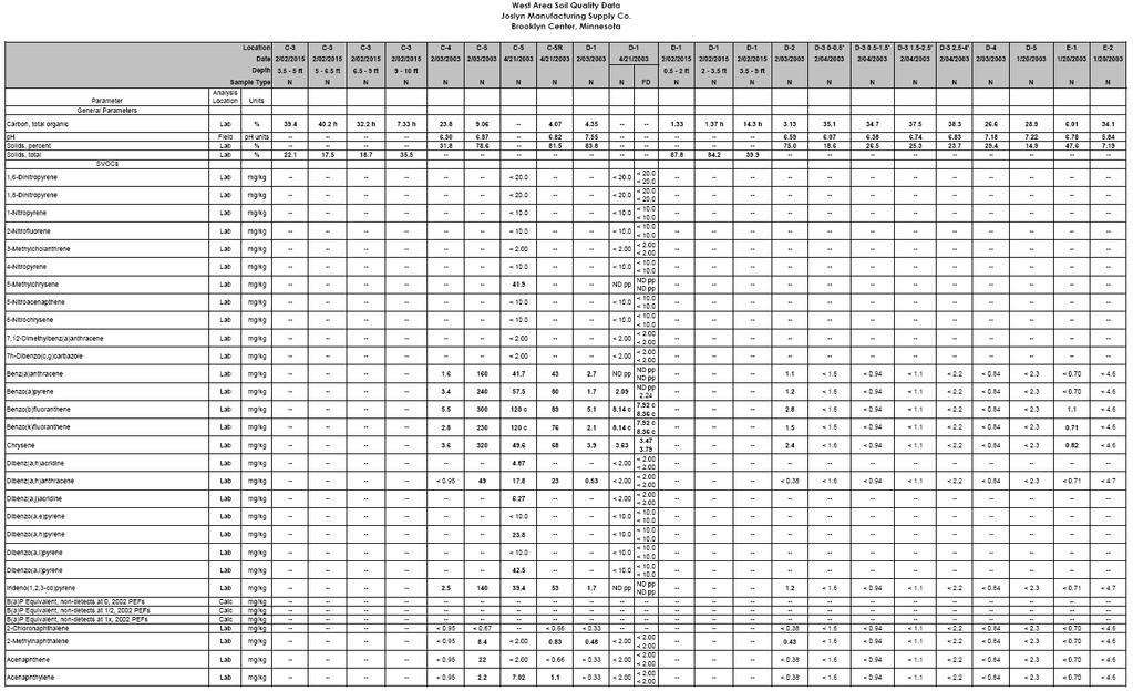
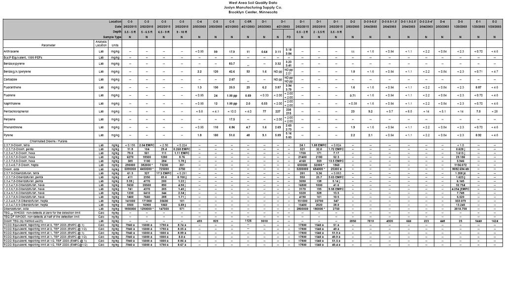
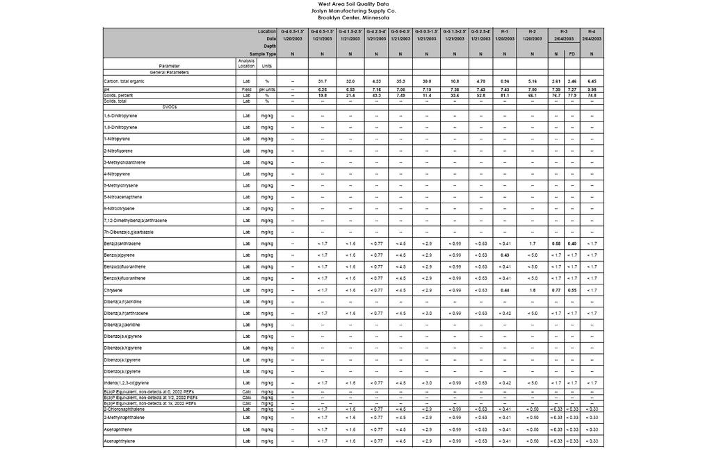
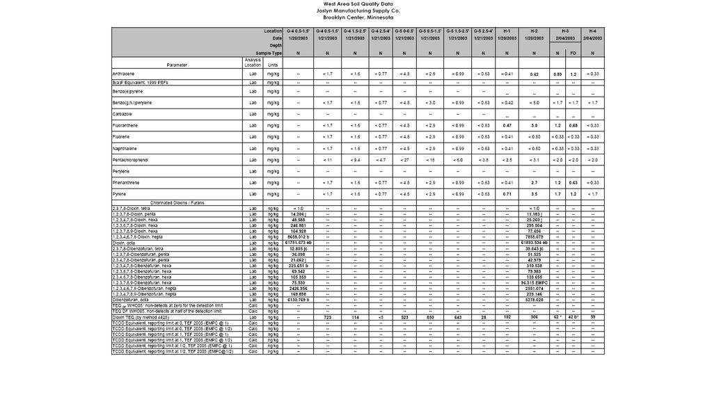
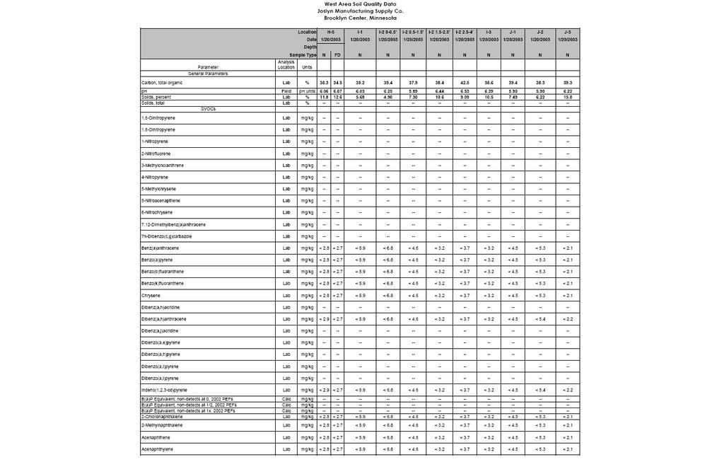
8 and the MPCA. Through the efforts of Joslyn and final actions during site redevelopment, much of the Site was successfully remediated and partially delisted from the PLP (State Superfund list) and NPL (Federal Superfund list). OU1 through OU4 are located within the redeveloped portions (blue portion on Figure 2). No additional actions are planned for those areas. 3.1 History of Middle Twin Lake Due to its location immediately adjacent to the Site, Middle Twin Lake has been investigated a number of times to assess potential adverse impacts caused by former wood treating activities. After dioxins were found at the Site, including in the West Area, the MPCA asked Joslyn to reevaluate potential adverse impacts by investigating fish tissue in Middle Twin Lake. Fish-tissue samples collected from Middle Twin Lake showed that existing fish-consumption advisories are protective of human health for dioxins. MPCA also had composite sediment samples collected and tested from Middle Twin Lake, which showed that dioxin concentrations were 10 times lower than the health-protective value established by the Minnesota Department of Health (MDH) and were unlikely to adversely impact public health. Based on the fish-tissue and sediment-investigation results, MDH and MPCA concluded that further assessment of Middle Twin Lake is not warranted at this time. 3.2 History of the West Area and Southern Lots (OU5) The West Area is comprised of wetlands and wooded uplands, and most of the area is within both the 100-year flood plain and the ordinary high-water level of Middle Twin Lake. The West Area was not used for significant operations associated with wood treating; however, it became impacted by surface-water runoff from the other areas where wood-treating operations were predominantly carried out (i.e. the area of the Site that has been redeveloped). Historical aerial photos show that a pond was present in the southern portion of the West Area. The Southern Lots are currently zoned for residential use. Some of the area is comprised of wetlands, and most of the area is forested with trees and shrubs. Approximately half of the area is within the 100-year flood plain. Historical aerial photographs indicate that soil filling may have occurred at the Southern Lots. 3.3 OU5 investigations and site characteristics Various investigations were completed from 1981 through 1999, revealing PCP, PAHs and dioxins at concentrations above recommended cleanup levels in the West Area. As a result, Joslyn installed a fence around the West Area in 2001 as an interim response measure to limit exposure of trespassers to contaminated soil. Joslyn completed additional investigations of the West Area and the Southern Lots between 2003 and 2009, and in 2014 and 2015 in order to more fully evaluate the potential ecological and human health risks associated with exposure to environmental conditions in OU5, and to aid in identifying appropriate remedial options. These investigations revealed dioxin levels in shallow soils in parts of the West Area that are higher than the MPCA s soil screening level. The highest concentration of dioxin detected was 176,621 ng/kg. A summary of all soil analytical data for the West Area of OU5 is found in Table 1, and a summary of soil analytical data for the Southern Lots and samples collected in the roadway is found in Table 2. Sample locations are shown on Figure 3. 3
9 Although PCP and PAH concentrations are also above recommended cleanup levels in isolated portions of the West Area, dioxins are the risk driver and are of primary concern. Table 3 shows the concentrations of dioxins found at varying depths in the soil samples (expressed as tetrachlorodibenzop-dioxin [TCDD] Toxicity Equivalency Quotient [TEQ]). Sampling activities in the southern parcel demonstrated that PAHs, PCP, and dioxins were not at concentrations of concern, and that the areas south of the Southern Lots do not need further investigation, or remediation at this time. Additionally, composite samples of shallow soils were collected in 2004 in conjunction with a street improvement project immediately west of the West Area and adjacent to the Southern Lots. Cumulatively, results of these investigations confirm that the contamination does not extend off of the Southern Lots. Federal law establishes an expectation that treatment will be used to address the principal threats posed by a site whenever practicable. The principal threat waste concept is applied to the characterization of source materials at a Superfund Site. In general, principal threat wastes are the source materials that contain hazardous substances and that act as a reservoir for migration of contaminants to groundwater, surface water, or air. These materials cannot be contained in a reliable manner or present a significant risk to human health or the environment should exposure occur. The decision to treat these wastes is made on a site-specific basis through a detailed analysis of remedial alternatives using the nine remedy selection criteria. The soils in OU5 are a combination of low-level and principal threat waste. The concentration of dioxins in soils in the central-southern portion of the West Area could present a potentially significant risk to human health or the environment should exposure occur; as a result, this soil is considered a principal threat waste. Although dioxin concentrations in the remainder of OU5 pose a risk, those soils are not considered a principal threat. It should also be noted that the mobility of the contaminants associated with OU5 soils is extremely low. 4.0 Human health and ecological risks from the West Area (OU5) As part of the West Area Feasibility Study, risks to human health and the environment from the existing contamination were evaluated to provide the basis for the proposed remedial action at OU5. The risk assessment evaluated the contaminants and exposure pathways that need to be addressed by the remedy. Three potential exposure pathways through which human or ecological receptors could be exposed to OU5 contaminants include: 1. Surface water Based on the results of the fish-tissue and lake sediment studies in Middle Twin Lake, there is not an ecological or human health risk to the lake from site contamination. 2. Groundwater Groundwater flows to the east away from Middle Twin Lake and is effectively captured and treated by a groundwater capture and treatment system. 3. Soil The risk evaluation focused on the soil exposure pathway and three exposure routes, including ingestion, inhalation, and absorption of contaminants through the skin from direct contact with contaminated soils. The surface water and groundwater exposure pathways have been addressed; only the soil exposure pathway remains to be addressed by the remedy. Remedial actions to address contamination in soils will effectively eliminate human health and ecological exposure pathways. 4
10 4.1 Evaluating soil exposure pathways Two key factors in the risk evaluation are the assumed future land use (e.g., residential, industrial, recreational) and the accessibility of OU5 soil contamination to human and ecological receptors. Although Joslyn intends to keep the West Area and Southern Lots as open, undeveloped space with a perimeter fence, the assumed future land use was based on the Brooklyn Center zoning designations of industrial for the West Area and residential for the Southern Lots. MPCA bases its determination of accessible soil depths on the likelihood of activities disturbing the soils. For example, it is more likely for shallower soils to be disturbed by common maintenance activities (e.g., landscaping or fencing installation) than for deeper soils to be disturbed. 4.2 Risk-based soil criteria The MPCA has developed risk-based soil concentration criteria for various exposure scenarios. The riskbased soil criteria are known as soil reference values (SRVs). MPCA selected a set of SRVs to compare to OU5 soil data by using conservative exposure assumptions for future land use and soil accessibility. MPCA then compared the selected SRVs to available OU5 soil-concentration data and determined that concentrations of dioxin in the shallow accessible soils of OU5 pose an unacceptable risk to human health if direct exposure to these soils occurred. The soil cleanup levels for OU5 are the risk-based SRVs derived by the MPCA based on conservative exposure scenarios for the West Area and Southern Lots. These will serve as the Preliminary Remediation Goals during the remedial actions and are found in Table 4. Figure 4 illustrates those portions of OU5 shallow soils that are proposed to be excavated. Some soils will be disposed off-site and some will be consolidated on-site. See descriptions of remedial alternatives 7 and 8 below. 5.0 Remedial alternatives Important factors considered in developing remedial alternatives are described below. 5.1 Regulatory classification of OU5 soils Five of the eight remedial alternatives considered for OU5 involve excavation of contaminated soils (Alternatives 3, 5, 6, 7 and 8, all summarized below). The excavation of contaminated soils at Superfund Sites and final management, treatment, or disposal location of the excavated soils is guided by a complex set of U.S. Environmental Protection Agency (EPA) and MPCA regulations and policies. A primary factor in determining where excavated contaminated soils can ultimately be managed, treated, or disposed is the defined area of contamination, or AOC. EPA defines this as an area where contamination is generally contiguous and of a similar nature but not necessarily uniform throughout the entire area. By this definition, the entire Joslyn Site is an AOC. Generally, contaminated soil that is excavated needs to either be managed on the property or disposed of off the property. If excavated soil is managed on the property, it will be consolidated into a smaller area and covered by a protective cap, such as a clean layer of soil or a building. 5
11 On-site consolidation within the AOC Contaminated soils may be excavated from OU5 and consolidated within the AOC (the Site) with the appropriate engineering controls to restrict human and ecological exposure. This scenario was used to develop a remedial alternative that consolidates and caps excavated soils within the West Area (Alternatives 5 and 8) and alternatives that consolidate and cap excavated soils outside of OU5 but within the Site (Alternatives 6 and 7). Off-site treatment and/or disposal outside of the AOC If soils excavated from OU5 are to be treated and/or disposed off-site (outside of the AOC), the soils must be classified for proper management under federal and state regulations. Under MPCA policies, approximately 40% of the OU5 soils are considered to contain a listed waste and must be managed as hazardous waste if they are to be disposed off-site. Under those same policies, approximately 60% of the OU5 soils do not contain a listed waste and can be disposed of in a Subtitle D landfill. Off-site disposal of all contaminated OU5 soils was considered (Alternative 3), as well as a combination of off-site disposal/on-site consolidation remedies where a portion of the soils are disposed off-site at a Subtitle D landfill and a portion of the soils are consolidated on site (Alternatives 7 and 8). 5.2 Flood plain and wetland considerations Much of OU5 is comprised of wetlands and is within the flood plain of Middle Twin Lake. Any construction or excavation in the wetlands and flood plain at OU5 requires substantial planning and permitting coordination with regulatory agencies including the Minnesota Department of Natural Resources, the Shingle Creek Watershed Management Commission, the United States Army Corps of Engineers, and the City of Brooklyn Center. Those alternatives that would involve altering the ground surface in OU5, whether by excavating, placing clean soil caps, or consolidating soils, would impact wetlands and the flood plain. These impacts were considered carefully when developing and evaluating the potential remedial alternatives described below. 5.3 Stormwater Management All eight alternatives except for the no action alternative include modifications to the current path of stormwater flow adjacent to and through OU5. Stormwater management modifications will improve the overall water quality of stormwater entering Middle Twin Lake and will protect the lake during and after the remedial action. 6.0 Evaluation of proposed cleanup alternatives The superfund process prescribes nine criteria used to evaluate proposed cleanup alternatives. The nine criteria are categorized into three groups and are described below. Threshold Criteria must be satisfied in order for a remedy to be eligible for selection as the preferred remedy: 1. Overall protection of human health and the environment pertains to how risks posed through each exposure pathway are eliminated, reduced, or controlled through treatment, engineering controls, and/or institutional controls. 2. Compliance with applicable and/or relevant and appropriate requirements (ARARs) from the federal, state, and local governmental and regulatory agencies. 6
12 Balancing Criteria are used to evaluate alternatives that meet the Threshold Criteria and are listed below. The alternative that most effectively balances these criteria, taking into consideration sitespecific circumstances, will be selected by the MPCA as the final cleanup action: 3. Long-term effectiveness and permanence refers to the ability of a remedy to reliably protect human health and the environment over time once cleanup levels have been met. This criterion includes consideration of residual risk that will remain on site following remediation and the adequacy and reliability of controls. 4. Reduction of toxicity, mobility, or volume of contaminants through treatment refers to the anticipated performance of the treatment technologies that may be included as part of a remedy. 5. Short-term effectiveness addresses the period of time needed to implement the remedy and any adverse impacts that may be posed to workers, the community, and the environment during construction and operation of the remedy until cleanup levels are achieved. 6. Implementability addresses the technical and administrative feasibility of a remedy from design through construction and operation. Factors such as availability of services and materials, administrative feasibility, and coordination with other governmental entities are also considered. 7. Cost-effectiveness addresses how much the remedy will cost. Modifying Criteria listed below may be considered in selecting a preferred alternative. Community comments on the Proposed Plan may be used to modify the MPCA preferred alternative: 8. State acceptance determines whether the MPCA accepts an option after receiving public comments. 9. Community acceptance considers the opinions of nearby residents and other stakeholders about the proposed cleanup plan. 7.0 Summary of remedial alternatives Eight remedial alternatives for OU5 were evaluated and are summarized below. For more information, please review the Feasibility Study and the associated MPCA approval and comment letters. Alternative 1 No further action To establish a baseline for comparison, the no-action alternative is evaluated at every Superfund Site. For this alternative, the only actions associated with OU5 are long-term routine operations and maintenance (O&M) tasks including maintaining fencing and other site maintenance and repairs, quarterly site inspections, and reporting. Estimated cost: $500,000 Estimated implementation time: ongoing Alternative 2 Stormwater management modifications Modification of the current path of stormwater flow adjacent to and through OU5 can help remove the potential of contaminant transport into Middle Twin Lake. This alternative includes installation of several stormwater treatment best management practices, including construction of stormwater treatment basins and installation of new storm sewers to convey surface runoff. Routine maintenance such as maintaining fencing and other site maintenance and repairs, quarterly site inspections and reporting would be performed in the long term following implementation of the remedy. This alternative was developed as a stand-alone remedial alternative and for use in conjunction with Alternatives 3, 4, and 5 described below. Estimated cost: $2,300,000 Estimated implementation time: less than one year 7
13 Alternative 3 Excavation for off-site treatment and disposal Under this alternative, the stormwater management modifications of Alternative 2 would be combined with the excavation of OU5 shallow soils that exceed cleanup levels. Excavated soils would undergo incineration at an out-of-state hazardous-waste incinerator and the incinerated soil would be disposed of at a hazardous-waste landfill. Excavations would be backfilled with clean soil to original grade and the area would be re-vegetated and wetlands re-established. Institutional controls would be placed on the property deed to restrict future land use as necessary and long-term routine maintenance, site inspections, and reporting would be conducted following implementation of the remedy. Estimated cost: $68,000,000 Estimated implementation time: more than one year Alternative 4 In-place soil cover Under this alternative, the stormwater management modifications of Alternative 2 would be combined with placement of a clean soil cap over the West Area. Contaminated soils excavated from the Southern Lots as part of the stormwater management modifications would be placed in the West Area prior to capping. The cap would consist of a geotextile overlaid with two feet of vegetated clean soil. This alternative would require significant flood plain and wetland mitigation due to the loss of flood plain and wetlands through placement of the soil cover. Institutional controls would be placed on the property deed to restrict future land use as necessary. Long-term routine maintenance, site inspections, and reporting would be conducted following implementation of the remedy. Estimated cost: $15,000,000 Estimated implementation time: less than one year Alternative 5 On-site consolidation with soil cover at West Area This alternative combines the stormwater management modifications of Alternative 2 with excavation of shallow contaminated soils from the northern portion of the West Area and from the Southern Lots for on-site consolidation. Excavated contaminated soils would be consolidated in the southern part of the West Area. The consolidation area would be capped with a vegetated soil cover (geotextile overlaid with two feet of clean soil). Flood plain and wetland mitigation would be required as part of this alternative, although less than for Alternative 4. Institutional controls would be placed to restrict future land use as necessary. Long-term routine maintenance, site inspections, and reporting would be conducted following implementation of the remedy. Estimated cost: $5,000,000 Estimated implementation time: less than one year Alternative 6 On-site consolidation with soil cover at Azelia Avenue Pond Contaminated shallow soils from OU5 (approximately 35,000 cubic yards) would be excavated and consolidated east of Building 1 within the Site. The proposed soil consolidation area is the current location of a stormwater pond (Azelia Avenue Pond) adjacent to a contaminated soil consolidation area created during development of the redeveloped portion of the Site. The consolidation area would be capped with a vegetated soil cover (geotextile overlaid with two feet of clean soil). A new stormwater pond would be constructed south of Building 1 and other stormwater management modifications would be implemented. Portions of the OU1 and OU2 groundwater pumpout systems within the proposed consolidation area would be modified. Excavations would be backfilled with clean soil to original grade and the area would be re-vegetated and wetland areas restored. Because there will be minimal net change in existing grade within OU5, it is anticipated that no significant flood plain mitigation will be required as part of this remedial alternative. Institutional controls would be placed on the property deed 8
14 to restrict future land use as necessary and long-term routine maintenance, site inspections, and reporting would be conducted following implementation of the remedy. Estimated cost: $5,900,000 Estimated implementation time: less than one year Alternative 7 Limited on-site consolidation with soil cover at Building 1A Pond Contaminated shallow soils from OU5 (approximately 35,000 cubic yards) would be excavated and a portion of that soil would be consolidated north of Building 1 within the Site and a portion of the excavated soil would be disposed off-site in a Subtitle D landfill. The proposed soil consolidation area is directly adjacent to the West Area and is the current location of a stormwater pond (Building 1A Pond) created during development of the redeveloped portion of the Site. The soil consolidation area would be capped with a vegetated soil cover (geotextile overlaid with two feet of clean soil). Modifications to the Azeila Avenue Pond would be needed to replace the functions of the filled Building 1A Pond. Excavations would be backfilled with clean soil to original grade and the area would be re-vegetated and wetland areas restored. Flood plain and wetland mitigation would be required as part of this alternative, although less than for Alternative 4, 5, and 8. Institutional controls would be placed on the property deed to restrict future land use as necessary and long-term routine maintenance, site inspections, and reporting would be conducted following implementation of the remedy. Estimated cost: $5,400,000 Estimated implementation time: less than one year Alternative 8 Limited On-site consolidation with soil cover in West Area Alternative 8 will require mitigation for flood plain and wetlands. Two options for obtaining the flood plain mitigation necessary to implement Alternative 8 were evaluated. The first option was to create additional flood plain at an off-site location (Alternative 8A) and the second option was to create additional flood plain on site within OU5 (Alternative 8B). In each variation of Alternative 8, contaminated shallow soils from OU5 (approximately 35,000 cubic yards) would be excavated and a portion of that soil would be consolidated in the West Area and a portion of the excavated soil would be disposed off-site in a Subtitle D landfill. The proposed soil consolidation area is located in the West Area and is the same location used in Alternative 5. The soil consolidation area would be capped with a vegetated soil cover (geotextile overlaid with at least two feet of clean soil). Excavations would be backfilled with clean soil to original grade and the area would be re-vegetated and wetland areas restored. Flood plain and wetland mitigation would be required as part of this alternative, although less than for Alternative 5. As noted above, two options for obtaining the flood plain mitigation necessary to implement Alternative 8 were evaluated: off-site flood plain mitigation (Alternative 8A) and on-site flood plain mitigation (Alternative 8B). Institutional controls would be placed on the property deed to restrict future land use as necessary and long-term routine maintenance, site inspections, and reporting would be conducted following implementation of the remedy. Alternative 8A Off-site flood plain mitigation Estimated cost: $5,400,000 Estimated implementation time: less than one year Alternative 8B On-site flood plain mitigation Estimated cost: $4,800,000 Estimated implementation time: less than one year 9
15 8.0 Summary of the preferred alternative Applying the nine criteria to the eight alternatives evaluated, the preferred alternative selected by MPCA for cleaning up OU5 is Alternative 8B, Limited on-site consolidation with soil cover in the West Area (On-site flood plain mitigation). Figure 5 illustrates the excavation and consolidation proposed for Alternative 8B. The Preferred Alternative achieves substantial risk reduction and protects human health and the environment through a combination of on-site containment and off-site disposal, engineering controls, and institutional controls. This alternative substantially reduces risk to human receptors because direct contact, inhalation, or ingestion of contaminated soil will be prevented. Institutional controls will also be implemented to ensure appropriate future land use. The Preferred Alternative will reduce the risks to both human and ecological receptors and, with proper planning and monitoring during implementation, is anticipated to manage of short-term risks. The Preferred Alternative will comply with ARARs. The Preferred Alternative for OU5 also offers the best balance of tradeoffs for the five balancing criteria. It provides long-term effectiveness by removing contaminants from the Site and provides long-term reduction in the pathways associated with contaminants remaining on-site. Although the principal threat wastes are being contained without treatment, the Preferred Alternative best balances technical feasibility and implementability, consideration of short-term risk to human and ecological receptors, and cost. For the Preferred Alternative, flood plain and wetland mitigation will be required and to the extent practicable, wetlands disturbed during the cleanup will be restored. Stormwater management modifications implemented as part of the Preferred Alternative will also help minimize the threat of contaminants migrating into Middle Twin Lake via stormwater runoff through OU5. MPCA will oversee Joslyn s actions to monitor air quality, control traffic, and control noise to minimizing impacts to the Site neighbors during cleanup construction activities. Trees will be preserved wherever possible on the western portion of OU5, and new trees will be placed to provide continued screening of the Site for neighbors to the south and across Middle Twin Lake. This remedy will result in some contaminated soil remaining on-site at depths greater than two feet beneath a clean soil layer, or in the consolidation area beneath a clean soil layer. Some of the contaminants in the soils are above levels that allow unlimited use and unrestricted exposure; as a result, a statutory review will be conducted within five years after initiation of remedial action, and every five years thereafter, to ensure that the remedy is, or will be, protective of human health and the environment. Applying the Evaluation Criteria to the eight remedial alternatives The nine evaluation criteria were applied to each of the eight remedial alternatives that are briefly summarized below. Please refer to the Feasibility Study for more information. 1. Overall protection of human health and the environment Because Alternative 1 and Alternative 2 are not protective of human health and the environment, they were eliminated from consideration as stand-alone remedial alternatives under the remaining eight criteria. 2. Compliance with ARARs Alternatives 2 through 8, with appropriate design and planning, will meet ARARs. The ARARs are not applicable to Alternative 1 as no actions would take place. 10
16 3. Long-term effectiveness Alternative 3 provides the greatest long-term effectiveness by removing contaminated materials from the Site and permanently eliminating the exposure pathways associated with contaminated soil. Alternatives 4, 5, 6, 7, and 8 provide long-term reduction of the exposure pathways associated with the contaminated soil, but not as well as Alternative 3. Alternatives 7 and 8 provide better long-term effectiveness by removing a portion of contaminated soil from the Site. 4. Reduction of toxicity, mobility, or volume of contaminants through treatment Alternative 3 reduces toxicity and volume through treatment. Alternatives 4, 5, 6, 7, and 8 do not include treatment as a component of the remedy and would not significantly alter the toxicity or volume of contamination at the Site. Alternatives 4, 5, 6, 7, and 8 would reduce mobility of the contaminated soils by capping or the removal of those soils to a Subtitle D landfill. 5. Short-term effectiveness Significant stormwater events during soil excavation could result in erosion and/or potential releases of contaminated soil or runoff to Middle Twin Lake. Scheduling the contaminated soil excavation during late fall or winter for Alternatives 3, 4, 5, 6, 7, and 8 would reduce the potential for significant stormwater events that could affect remedial operations. Stormwater controls proposed as part of Alternatives 3, 4, 5, 6, 7, and 8 would also help prevent releases of contaminants to Middle Twin Lake via soil erosion or runoff. Alternatives 3, 6, and 7 involve excavating the most highly contaminated soils in the West Area. These materials would be staged and loaded for off-site transportation under Alternative 3 and for consolidation at the Site under Alternative 6 and 7. Compared to Alternative 4, 5, or 8, this staging and loading could result in longer potential exposure to higher concentrations of COCs for workers, residents of the local neighborhoods, and to surface water. 6. Implementability The six remaining alternatives can be implemented using generally available construction methods, equipment, and materials. However, there are several implementability issues that pertain to specific alternatives: Alternatives 3 through 8 require work in wetlands and the associated regulatory agency coordination and permitting. The regulatory permitting to treat and dispose of excavated OU5 soils off-site under Alternative 3 has greater administrative and logistical complexity than some of the other alternatives. Alternatives 4 and 5 would need significant flood plain mitigation. Alternatives 7 and 8 require flood plain mitigation as well, but less than required under Alternative 5. Alternative 8A would require coordination with off-site property owner(s) to obtain necessary flood plain mitigation. Alternative 8B would create flood plain within OU5 of the Site. Alternatives 6 and 7 would require coordination with the lessee of the developed portion of the Site and significant stormwater management changes due to the proposed filling of the Azelia Avenue Pond in Alternative 6 and the Building 1A Pond in Alternative Cost effectiveness The estimated cost of Alternative 3 ($68M) is significantly higher than those of Alternatives 5, 6, 7, and 8 which have similar total estimated cost ($4.9M to $5.9 M). The table that follows illustrates whether the nine criteria are met or not met for each alternative. 11
17 Option A 8B Summary of cleanup options Description of cleanup activity Take no action, monitor the Site Protects human health and the environment ß Complies with federal, state, and local law Long-term effectiveness and permanence Reduces toxicity, mobility, or volume of contaminants Short-term effectiveness (can be implemented promptly) Implementability N/A ß ß ß ß Modify stormwater ß ß ß path Excavate, incinerate, and dispose of contaminated soils; modify stormwater path Cover area with clean soil Consolidate & dispose excavated soils; mitigate flood plain Move contaminated soils to existing pond; cap with clean soil; construct new stormwater pond Consolidate & dispose excavated soils; implement extensive stormwater management changes Consolidate & dispose excavated soils; create flood plain off property Consolidate & dispose excavated soils; create flood plain on property ß ß ß ß ß ß Cost $0.5M $2.3M $68M $15M $5M $5.9M $5.4M $5.4M $4.8M 12
18 9.0 Public input The MPCA will present this Proposed Plan at a public meeting on April 12, There will be an open house beginning at 5:30 p.m., and a short formal presentation at 7:00 p.m. The meeting will be held at the Hennepin County Library, Brookdale Room ABC, located at 6125 Shingle Creek Parkway in Brooklyn Center, Minnesota The MPCA will accept written public comments until May 5, The MPCA will review these comments and make a final decision on the remedy selection, which will be documented in the ROD. The ROD will include a summary of significant comments, criticisms, and any new relevant information, along with MPCA staff response to those comments. Joslyn will then implement the selected remedy in accordance with the ROD. 13

19 Figure 1: Site location. Figure from: Focused Feasibility Study REVISION 3, Operable Unit 5 West Area Soils, Joslyn manufacturing & Supply Co. Site, Brooklyn Center, Minnesota, Barr Engineering Co., January

20 Figure 2: Site map 15

21 Figure 3: West Area sample location map. Figure from: Focused Feasibility Study REVISION 3, Operable Unit 5 West Area Soils, Joslyn manufacturing & Supply Co. Site, Brooklyn Center, Minnesota, Barr Engineering Co., January

22 Figure 4: Map of OU5 soil excavation areas 17

23 Figure 5: Alternate 8B Proposed Plan. Figure from: Focused Feasibility Study REVISION 3, Operable Unit 5 West Area Soils, Joslyn manufacturing & Supply Co. Site, Brooklyn Center, Minnesota, Barr Engineering Co., January

24 Table 1. Historic Soil Quality Data 19
25 20
26 21
27 22
28 23
29 24
30 25
31 26

32 27

33 28
34 29
35 30
36 31

37 32


38 Table 2. Historic Soil Quality Data Southern Lots and Roadway 33

39 Table 3. Soil Boring Matrix 34
40 Table 4. Preliminary Remediation Goals 35