DRAFT PRELIMINARY ENGINEERING REPORT
|
|
|
- Hilary Tucker
- 5 years ago
- Views:
Transcription
1

2 DRAFT PRELIMINARY ENGINEERING REPORT US 27/ SR 25 / OKEECHOBEE PD&E STUDY Financial Management Number: Federal Aid Project Number: P ETDM Number: 9891 County: Miami-Dade Florida Department of Transportation District Six Miami, FL January, 2016
3 DRAFT PRELIMINARY ENGINEERING REPORT US 27/ SR 25 / OKEECHOBEE PD&E STUDY Financial Management Number: Federal Aid Project Number: P ETDM Number: 9891 County: Miami-Dade This preliminary engineering report contains detailed engineering information that fulfills the purpose and need for project US 27/SR 25/ Okeechobee PD&E Study. January, 2016 Prepared by: Metric Engineering, Inc. Robert A. Linares, P.E
4 Table of Contents Table of Contents (continued) SECTION PAGE NO. SECTION PAGE NO. 1. EXECUTIVE SUMMARY Project Purpose Project Description Deficiencies Commitments and Recommendations Commitments Recommendations INTRODUCTION Purpose of the Report Project Description Project Purpose Project Background/Previous Studies Need for Improvements System Linkage Transportation Demand Operational Deficiencies Safety Multimodal Considerations Evacuation Routes and Emergency Services Consistency with SIS and Local Transportation Plans Other Projects in the Study Area EXISTING CONDITIONS AND EVALUATION Phase I Data Gathering Phase Roadway/Structural Characteristics Typical Sections and Functional Classifications Posted Speed Right-of-Way Intersections and Signalization Existing Interchanges Horizontal and Vertical Alignment Lighting Existing Bridges/Structures Structures Condition Transit Facilities Pedestrian and Bicycle Facilities Utilities Intelligent Transportation System (ITS) Features Soils Drainage Existing Traffic Conditions Field Observations Summary Data Collection Design Traffic Factors Safety Environmental Characteristics Land Use Cultural Features and Community Services Section 4(f) Resources Aesthetics Archaeological and Historical Resources Natural and Biological Features Comprehensive Everglades Restoration Program (CERP) Floodplains Groundwater Wetland and Surface Waters Wildlife and Habitat Other Physical Features Air Quality Noise Contamination Navigation Phase II Data Analysis Phase Project Segmentation Roadway Characteristics Cross Section Horizontal Alignment Vertical Alignment Stopping Sight Distance Intersection Sight Distance Pavement Condition Traffic/Operational Characteristics Evaluation Level of Service Access Management Median Opening Spacing Driveway Connection Spacing Traffic Signal Spacing Signing and Marking Safety Phase III Conclusions and Recommendations DESIGN CONTROLS & STANDARDS Strategic Intermodal System (SIS) Table of Contents Draft Preliminary Engineering Report i
5 Table of Contents (continued) Table of Contents (continued) SECTION PAGE NO. SECTION PAGE NO. 4.2 Geometric Design Criteria Drainage Criteria Water Quality Criteria Florida Department of Environmental Protection (FDEP) SFWMD Department of Regulatory and Economic Resources (DRER) Water Quantity Criteria SFWMD - Discharge Rate DRER - Discharge Rate Stormwater Management Facilities FDOT Reference Manuals ALTERNATIVES CONSIDERED Phase One: Conceptual Design Analysis No Build Alternative Transportation Systems Management and Operational (TSM&O) Alternatives Major Alternatives Alternative Corridor Analysis Phase Two: Alternative Generation and Preliminary Evaluation Segmental Improvement Areas (SIA) Preliminary Alternative Evaluation Phase Three: Final SIA Evaluation Phase Four: Selection of Recommended Alternative RECOMMENDED ALTERNATIVE Preliminary Roadway Design Proposed Typical Sections Horizontal Alignment Vertical Alignment Bicycle and Pedestrian Accommodations Access Management Potential Design Exceptions and Variations Traffic Analysis Development of Future Traffic Projections Future AADTs Future Intersection Volumes Future Operational Analysis Intersection Analysis Segment and Network Analysis Structural Analysis Geotechnical Considerations Utility Impact Potential Drainage Permit Requirements Potential Intelligent Transportation System (ITS) Features ITS Concept Layout Cost Estimate Right-of-Way Impacts Construction Cost Estimate Cost and Schedule Risk Analysis Maintenance of Traffic Environmental Impacts Aesthetics Section 4(f) Resources Wetland and Surface Waters Comprehensive Everglades Restoration Program (CERP) Floodplains Wildlife and Habitat Air Quality Noise Contamination Summary of Public Involvement Activities FIGURE NO. List of Figures PAGE NO. 2-1 Project Location Map Okeechobee Road Linkage to Major Travel Corridors Projects in the Vicinity Existing Conditions and Evaluation Analysis Flowchart Existing Typical Sections Major Intersection Characteristics Existing Bridges Existing Soil Survey Existing Drainage Basins Field Observations Summary Data Collection Locations A Existing (2012) Peak Hour Intersection Traffic Volumes B Existing (2012) Peak Hour Intersection Traffic Volumes Hourly Distribution of Weekday Traffic Volumes Summary of Speed and Travel Time Data Historical Traffic Information in the Project Vicinity Table of Contents Draft Preliminary Engineering Report ii
6 List of Figures (continued) List of Figures (continued) FIGURE NO. PAGE NO. FIGURE NO. PAGE NO Land Use West of HEFT Land Use East of HEFT Community Services Conservation Lands Wetlands West of HEFT Wetlands East of HEFT Designated Wildlife Habitat Potential Contamination Concerns Solid Waste Sites Potential Contamination Sites Existing Facility Evaluation Summary Summary of Existing Level of Service Alternative Selection Process Corridor Considerations Segmental Improvement Areas (SIA) SIA 1 Alternatives 1A & 1B SIA 2 Alternatives 2A & 2B SIA 3 Alternatives 3A & 3B SIA 4 Alternatives 4A & 4B a SIA 5 Alternatives 5A & 5B b SIA 5 Alternative 5C a SIA 6 Alternatives 6A & 6B b SIA 6 Alternatives 6C & 6D c SIA 6 Alternative 6B Modified a SIA 7 Alternatives 7A & 7B b SIA 7 Alternatives 7C & 7D c SIA 7 Alternatives 7E & 7F d SIA 7 Alternative 7C Modified SIA 8 Alternatives 8A & 8B AHP Results Sensitivity Analysis Results SIA s 1, 3 & 4 Design Year (2040) Intersection PHV SIA 5 Design Year (2040) Intersection PHV SIA 6 No Build 2040 Intersection PHV SIA 6 Alternative 6B Modified 2040 Intersection PHV SIA 7 No Build Intersection PHV SIA 7 Alternative 7C Modified Intersection PHV SIA 8 Design Year (2040) Intersection PHV ITS Concept Layout Future Construction Segments Construction Segment 2 MOT Construction Segment 6 MOT Phase Construction Segment 6 MOT Phase 1 (continued) Construction Segment 6 MOT Phase Construction Segment 6 MOT Phase 2 (continued) Construction Segment 5 MOT Phase Construction Segment 5 MOT Phase 1 (continued) Construction Segment 5 MOT Phase Construction Segment 5 MOT Phase 2 (continued) Construction Segment 5 MOT Phase Construction Segment 4 MOT Phase 1A Construction Segment 4 MOT Phase 1B Construction Segment 4 MOT Phase 1B (continued) Construction Segment 4 MOT Phase Construction Segment 4 MOT Phase 2 (continued) Construction Segment 4 MOT Phase Construction Segment 4 MOT Phase 3 (continued) Construction Segment 3 MOT Phase Construction Segment 3 MOT Phase Construction Segment 3 MOT Phase Potential Mitigation Site (M1) Potential Mitigation Site (M2) TABLE NO. List of Tables PAGE NO. 1-1 Summary of SIA Evaluation Results Action Plan Proposed Improvements Existing and Future Traffic Volumes FDOT High Crash Location List Plan Consistency Existing Characteristics of Major Facilities along the Project Corridor Existing Lane Configuration Existing Utilities Preliminary Soil Survey General Soil Condition Data Type and Sources Traffic Factors Obtained from 2011 FTI DVD Recommended Traffic Factors Crash Summary Krome Avenue to the HEFT Crash Summary E of HEFT to NW 79 th Avenue Fatal Crash Summary Krome Avenue to NW 79 th Avenue Okeechobee Road Spot Safety Ratio Summary NW 103 rd Street Spot Safety Ratio Summary Okeechobee Road Segment Safety Ratio Summary Table of Contents Draft Preliminary Engineering Report iii
7 TABLE NO. List of Tables (continued) PAGE NO Identified Historic Resources within the Historic APE Species Listed as Threatened or Endangered by the USFWS or FWC High and Medium Risk Sites Horizontal Curves along Okeechobee Road Segment and Network Analysis Results Median Compliance Standards Existing Median Openings Existing Signal Spacing Strategic Intermodal System Criteria Roadway Design Criteria Bridge Design Criteria Florida Precipitation Rainfall Amount (Zone 10) Evaluation of TSM&O Alternatives Segmental Improvement Area (SIA) Breakdown SIA 1 Preliminary Alternative Evaluation SIA 2 Preliminary Alternative Evaluation SIA 3 Preliminary Alternative Evaluation SIA 4 Preliminary Alternative Evaluation SIA 5 Preliminary Alternative Evaluation SIA 6 Preliminary Alternative Evaluation SIA 7 Preliminary Alternative Evaluation SIA 8 Preliminary Alternative Evaluation Preliminary Alternative Evaluation Elimination Process Summary of SIA Evaluation Results Proposed Horizontal Curves Proposed Vertical Curves Proposed Median Opening Changes Recommended Traffic Factors Intersection LOS Summary (Year 2040) Segment MOE Summary (Year 2040) Proposed Recommendations for Structures Basin Summary ITS Cost Estimate Future Construction Segments Construction Cost Estimate by Design Segment Summary of Risk Analysis Results Project Summary of Risk Analysis Results Construction Cost by Segment Summary of Risk Analysis Results Schedule Milestones/Activity Duration 6-26 List of Appendices Appendix A Reference Documents Appendix B Crash Analysis Appendix C FEMA FIRM Maps Appendix D Existing Conditions Evaluation Appendix E Analytical Hierarchy Process (AHP) Results Appendix F Design Plans F1 Typical Section Package F2 Concept Plans F3 Design Variation Package Appendix G Drainage Information Appendix H Cost Estimate H1 Relocation and Right-of-Way Cost Estimate H2 Long Range Estimate (LRE) Appendix I Public Involvement Documentation I1 Public Involvement Plan (Pip) I2 Summary of Meetings I3 Project Advisory Committee I4 Elected Official/Agency and Public Kick-Off Meeting I5 Alternatives Public Workshop #1 I6 Alternatives Public Workshop #2 I7 Meetings with Elected Officials I8 Minutes from Presentation to the MPO TPC, CTAC, BPAC and FTAC Appendix J Additional Traffic Information Table of Contents Draft Preliminary Engineering Report iv


8 1 EXECUTIVE SUMMARY The Florida Department of Transportation (FDOT) is planning to upgrade a segment of US 27/SR 25/Okeechobee Road in Miami-Dade County from SR 997 Krome Avenue to just west of NW 79 th Avenue, an a pproximate distance of 9.7 miles. A s part of the planning process, a P roject Development and Environment (PD&E) Study was initiated and the engineering documentation is included in this report. Okeechobee Road is a r egionally significant arterial traversing the state transporting goods and services from its origin in Miami-Dade County to the Florida-Georgia state line. 1.1 Project Purpose The purpose of this project is to improve overall traffic operations and safety along Okeechobee Road. The proposed improvements include not only the provision of safety and mobility features along Okeechobee Road but also Frontage Road enhancements and intersection improvements including grade-separated intersections. In addition, bridge widening/canal crossing improvements and multimodal options were also considered. In summary this study includes both minor/transportation Systems Management & Operations (TSM&O) options as well as major improvements. 1.2 Project Description Okeechobee Road serves as a restrictive highway due t o the lack of access points and the presence of a frontage road. It is part of the State s Strategic Intermodal System (SIS) and carries a s ignificant number of large trucks (over 15% daily). The western segment of Okeechobee Road (from Krome Avenue to the Homestead Extension of Florida's Turnpike (HEFT)) is classified as a di vided, rural principal arterial with two lanes in each direction and a discontinuous two lane frontage road to the north. The eastern segment (from the HEFT to NW 79 th Avenue) is classified as a Okeechobee Rd is bordered by residential and commercial land uses to the north, by the Miami Canal and industrial land uses to the south. divided, urban principal arterial with three lanes in each direction and a two lane frontage road to the north. The Miami Canal (C-6) borders Okeechobee Road to the south for the entire project segment. It should be noted that NW S River Drive runs parallel to Okeechobee Road along the eastern segment south of the Miami Canal. Because there are six bridges that provide access from NW S River Drive to Okeechobee Road, NW S River Drive functions as an additional frontage road. NW S River Drive however, is also the most important, highly utilized corridor within the Town of Medley Executive Summary Draft Preliminary Engineering Report 1-1

9 and serves as a major collector, serving the industrial areas south of the project corridor. It should be noted that NW S River Drive is owned and maintained by the Town of Medley and is not on the State Roadway System. 1.3 Deficiencies The overall study was initiated with a d etailed, comprehensive analysis of existing substandard conditions. In general terms, some of the most critical existing deficiencies include: Geometric deficiencies: Substandard turning radii at canal crossings and all intersections as well as insufficient sight distance for the design vehicle WB-62FL. Capacity deficiencies at signalized intersections and congestion at existing access points as well as along Okeechobee Road east of NW 87 th Avenue. Operational deficiencies result from a number of design deficiencies in the area including insufficient capacity at major signalized intersections, substandard turning radii at canal crossings, close proximity of signalized intersections at cross streets due to closely spaced parallel facilities (i.e. NW S River Drive, Okeechobee Road and Frontage Road), congestion at existing access points and insufficient/deficient signage. The high volume of heavy truck traffic that originates or is destined to this area compounds the problem. Competing maneuvers between trucks and cars at the limited number of access points creates confusion among drivers. Additionally, due t o the close proximity of the intersections, truck queues block many of the intersections at NW S River Drive and t he Frontage Road and cause severe weaving issues for vehicles traveling along Okeechobee Road and wishing to continue traveling along NW S River Drive or the Frontage Road. Access deficiencies: As a principal arterial SIS facility, Okeechobee Road emphasizes mobility over access and therefore has limited access connections where a large percentage of vehicles are processed through. Safety deficiencies consisting of high crash and injury rates throughout the project limits. The need for improvement was established based on these findings/deficiencies. The types of improvements warranted include: Safety improvements Provide operational improvements at key project intersections (including grade-separated options) Provide pedestrian and bicycle enhancements Provide adequate capacity to meet future traffic demand Provide greater separation between signalized intersections where feasible along the cross streets Provide adequate intersection geometry to allow sufficient room for large trucks to perform turning maneuvers Provide aesthetically pleasing solutions that promote mobility and accessibility Minimize any social or environmental impacts A comprehensive alternative selection process was utilized for assessing project alternatives. Alternatives strive to emphasize engineering, environmental and economic aspects while adhering to sound aesthetic design principles. Other elements included geometric, operational and safety issues, drainage, utilities, soils and g eotechnical issues, project social and environmental impacts, project costs, etc. Although several alternate corridor locations were considered during the course of this study, it was concluded that the existing corridor location offered the only feasible choice for the fulfillment of the project need. Executive Summary Draft Preliminary Engineering Report 1-2

10 In order to facilitate the generation and evaluation of alternatives, the project was divided into eight (8) distinct Segmental Improvement Areas (SIA), four covering the rural western portion extending from the begin project to the HEFT interchange and four covering the project s urban eastern area from the HEFT interchange to end of project. A total of twenty-three build alternatives were evaluated against each other at the preliminary evaluation phase. This preliminary screening identified ten inferior alternatives, five superior alternatives and selection of 13 alternatives to be carried on to the next phase for further consideration. Subsequently, a final evaluation phase utilizing the Analytical Hierarchy Process (AHP), a decision making process, was conducted to further screen the 13 remaining alternatives. 1.4 Commitments and Recommendations The FDOT has made a series of commitments and recommendations during the course of the PD&E study pertaining to the Okeechobee Road corridor improvements. The following sections summarize the commitments and recommendations that will be adhered to during future project phases Commitments During construction, the FDOT will comply with all provisions of the most recent version of the FDOT Standard Specifications for Road and Bridge Construction. Additionally, in order to minimize the impacts of this project on t he human environment, the Department is committed to the following measures: 1. A minimum of a 4 foot buffer between the Okeechobee Road through lanes and the acceleration lanes will be provided During final design 2. Although a dewatering permit from Miami Dade County Department of Regulatory and Economic Resources will not be required, prior to construction, the FDOT will notify DRER of any dewatering activities. 3. Investigate further potential safety enhancements along the Frontage Road Corridor. 4. The continuity of Frontage Road will be maintained within the City of Hialeah Gardens. 5. If future changes in the project s recommendation result in the closure of the median opening that provides access to the Miami-Dade County Aviation Department (MDAD) properties (Folio numbers: and ), the FDOT will coordinate with MDAD to ensure adequate access. 6. The Department will undertake mitigation measures in order to relocate Bernie Wilson Park within the vicinity of its current location in the City of Hialeah Gardens. 7. Access to the City of Hialeah Gardens City Hall complex and Miami Dade Fire Department Station # 28 will be improved via a new a new access road off of NW 103rd Street. 8. Impacts to the City of Hialeah Gardens Police Department parking will be replaced. 9. A bold landscape feature will implemented near the Okeechobee Road/NW 87th Avenue/NW 103rd Street area. 10. The Brother's to the Rescue Monument will be relocated. 11. Will continue to coordinate with Miami Dade County Public Schools for access improvements to the School Bus Depot along NW 87th Avenue. 12. Level Two aesthetic considerations for second and third level bridge structures will be implemented. Executive Summary Draft Preliminary Engineering Report 1-3
11 1.4.2 Recommendations Several alternate corridor locations were considered during the course of this study; however, it was concluded that the existing corridor location offered the best potential for the fulfillment of the project needs. Twenty-three build options were developed and a comprehensive engineering and environmental evaluation of these options was conducted using various multicriteria evaluation methods. Results of the public involvement effort as well as the engineering and env ironmental studies indicate that alternatives 1A, 2A, 3B, 4B, 5C, 6B Modified, 7C Modified and 8B are the best choice to fulfill the project objectives. Additionally, the district has designated the segment of Okeechobee Road from the Turnpike to NW 79 th Avenue as a future concrete project which includes the following planned design projects: FM Numbers: , , , and A brief description of each recommended alternative follows: SIA 1 (Begin project to just east of NW 186 th Street) Alternative 1A realigns the Krome Avenue intersection to only provide one traffic signal in the eastbound direction as opposed to the existing two signals. It also features additional northbound to westbound and westbound to southbound left turn lanes thus providing needed additional capacity. Concrete pavement will be pr ovided at the approaches to the Krome Avenue intersection. SIA 2 (From just east of NW 178 th Street to just east of NW 170 th Street) Alternative 2A closes an existing Okeechobee Road median opening with Frontage Road providing a right-out only and thus providing the necessary space to fully develop adequate acceleration and deceleration lanes in all directions at NW 170 th Street. SIA 3 (From just west of NW 129 th Street to just east of NW 154 th Street) Alternative 3B closes an existing Okeechobee Road median opening at NW 127 th Avenue and relocates it slightly west to NW 129 th Avenue. This modification provides additional spacing along Okeechobee Road between NW 154 th Street and the new NW 129 th Avenue and thus allows for the provision of adequate acceleration and deceleration lanes. It also provides concrete pavement along Okeechobee Road at the approaches to the NW 154 th Street intersection. SIA 4 (HEFT/Okeechobee Road Interchange) Alternative 4B provides an additional left turn lane (to provide a t otal of two left turn lanes) from eastbound Okeechobee Road to northbound HEFT in addition to the improvements from the HEFT and SR 924/Gratigny Expressway West Extension PD&E Studies. These previously proposed HEFT and SR 924 improvements include the provision of a new eastbound Okeechobee Road to southbound HEFT on-ramp, a n ew northbound HEFT to eastbound Okeechobee Road off-ramp, and a future HEFT/SR 924 connection. Along the corridor of Okeechobee Road concrete pavement is also recommended. SIA 5 (From just west of NW 138 th Street to just east of NW 107th Avenue) Alternative 5C widens Okeechobee Road to add necessary dual-left turn lanes destined northbound and southbound along NW 138 th Street as well as two westbound right turn lanes for increased capacity and to eliminate queue spilling over onto the mainline. Additionally, a signal is provided at the intersection of NW 138 th Street and Frontage Road as well as additional turn lanes and more ample intersection turning radii. This alternative increases the capacity of NW 107 th Avenue and reduces delays along Okeechobee Road by providing three westbound turbo lanes as well as an additional northbound left turn lane along NW 107 th Avenue requiring widening of the bridge over the Miami Canal. Along the entire corridor concrete pavement is also recommended. SIA 6 (From just west of NW 122 nd Street to just east of NW 92 nd Avenue) Alternative 6B Modified grade-separates the Okeechobee Road mainline over NW 116 th Way. T he movements to/from Okeechobee Road will be pr ovided via a system of ramps underneath the Okeechobee Road mainline to two new intersections at Frontage Road. It also provides an elevated flyover ramp connection from southbound NW 116 th Way to eastbound Okeechobee Road eliminating heavy left turn movements from the surface streets further simplifying phasing and reducing delay. This alternative results in less right-of-way impacts and less impacts to potentially contaminated sites, avoids new piers in the Miami Canal as well as reduced construction costs; thus, Alternative 6B modified is the recommended alternative in this SIA. Due to costly business and residential relocations, reconstruction of NW S River Drive, further refinements in traffic operations and continued stakeholder coordination, the previously top ranked alternatives in this SIA (Alternatives 6B and 6D) were further refined and combined to develop 6B Modified. It is also recommended to provide concrete pavement throughout the entire corridor as well as along NW S River Drive where the improvements are proposed. SIA 7 (From just west of NW 106 th Street to just east of NW 87 th Avenue) Alternative 7C Modified provides two flyover ramps from northbound/southbound NW 87 th Avenue to westbound/eastbound Executive Summary Draft Preliminary Engineering Report 1-4
12 Table 1-1 Summary of SIA Evaluation Results Okeechobee Road, respectively. Both of these ramps will address the heavy left turn volumes accessing Okeechobee Road from NW 87 th Avenue as well as simplifying the signal phasing on the surface streets. It also elevates the Okeechobee Road mainline at a third level over NW 87 th Avenue and over the two flyovers while providing a service road for the local movements to NW 87 th Avenue. Lastly, this option realigns NW 103 rd Street further to the north, removing the existing southward curve, to create sufficient separation along NW 87 th Avenue between the intersections with NW 103 rd Street and Frontage Road as well as to provide the required storage for turning movements. Realignment of NW 103 rd Street also allows vehicles traveling westbound along NW 103 rd Street destined to eastbound Okeechobee Road to access the proposed southbound NW 87 th Avenue to eastbound Okeechobee Road flyover ramp. The realignment of NW 103 rd Street will result in the replacement of most of Bernie Wilson Park with a new at-grade roadway facility (i.e. new NW 103 rd Street). Due to the impacts to Bernie Wilson Park, a Programmatic Net Benefit Section 4(f) Evaluation was prepared for this study. A summary is included in Section 6 of this document. It is also recommended to provide concrete pavement throughout the entire corridor as well as along NW S River Drive where the improvements are proposed. SIA 8 (From just west of NW 95 th Street to just east of NW 79 th Avenue) Alternative 8B features the provision of additional capacity along both the mainline and at all the SIA intersections as well as more ample intersection turning radii to facilitate operations. Additionally, a westbound turbo lane is provided along the Frontage Road for vehicles turning right from NW 95 th Street destined to westbound Frontage Road. This requires the relocation of the entrance to BJ's warehouse further east. Additionally a new westbound connection to Okeechobee Road from Frontage Road is provided in order to facilitate egress maneuvers from major traffic generators land locked by SR 826 and Okeechobee Road. It is also recommended to provide concrete pavement throughout the entire corridor as well as along NW S River Drive where the improvements are proposed. Table 1-1 provides a summary of the alternative selection process and the reason for selection. A summary of the characteristics and main features of the recommended alternative as well as the associated environmental and community impacts are detailed in Section 6 of this document. SIA Remarks Although both alternatives considered (1A and 1B) effectively address the existing deficiencies, and provides concrete pavement along the corridor and approaches at the intersection of Krome Avenue, alternative 1A also avoids impacting the access to the Miami-Dade County Aviation Department (MDAD) property. Access impacts to this parcel would result in higher right-of-way costs and significant controversy potential due to opposition from MDAD. Alternative 2A not only provides much needed aux iliary lanes, but also increases safety by reducing the number of potential conflict points. The relocation of access provision to land uses north of Okeechobee Road, away from the existing horizontal curve, is also a safer condition than the other alternative considered. Alternative 3B provides additional distance between contiguous median openings as well as adequate acceleration and deceleration lanes for all movements. In general terms, this alternative promotes greater safety and better access management features than alternative 3A. Concrete pavement is recommended along the NW 154 Street and Okeechobee Road intersection. The recommended alternative (4B) is similar to the alternative proposed for Florida s Turnpike Enterprise (FTE) Homestead Extension of Florida Turnpike (HEFT) PD&E Study. The only modification is the provision of an additional eastbound left turn lane to northbound HEFT ramp for operational reasons. Although alternative 5A and 5C provide adequate solutions to the many operational deficiencies within this SIA, 5C is slightly better because of the following reasons: 1) the widening of the NW 138 th Street bridge allows for the dual westbound/eastbound left turn lanes to turn concurrently; 2) the provision of a single southbound to westbound right turn lane at NW 138 th Street reduces the weaving distance to the HEFT northbound on-ramp. Although alternatives 6D and 6B Modified are similar from an operational standpoint, 6B Modified avoids reconstruction of NW S River Drive, two expensive skewed bridges over the Miami Canal as well as significant R/W and relocation impacts. Some of its most important advantages include the following: 1) the provision of a grade-separation of Okeechobee Road at NW 116 th Way in conjunction with a southbound to eastbound flyover will result in major operational and s afety improvements, addressing a major need; 2) the preservation of local connectivity and ac cess connections are important features and reduce controversy potential. Four of the alternatives (7A, 7B, 7C and 7C Modified) are clearly superior to the other three considered options (7D, 7E and 7F). Although alternatives 7A and 7B avoid major environmental impacts (e.g. impacts to Bernie Wilson Park, Brothers to the Rescue Memorial, etc.), providing grade separations over NW 87 th Avenue and NW 103 rd Street alone without addressing the immediate surrounding network would result in a degr adation of the access points on/off the mainline and consequently impact the operations of the mainline downstream from these points. These two alternatives do not fully address the operational needs of the entire SIA and thus do not entirely meet the project objective. Although alternatives 7C and 7C Modified have some environmental impacts to local park facilities, they do provide major enhancements in all engineering categories (traffic operations, safety, access, connectivity, etc.) and address all of the project needs. Alternative 7C Modified with Okeechobee Rd mainline at a t hird level results in lower construction costs and reduced flooding potential from proposed impacts to SFWMD C6 & C7 canals under alternative 7C. In addition, the relocation of NW 103 rd Street is an es sential component of the efficient operational solution to the contiguous street network within this SIA. Although both alternatives considered (8A and 8B) are generally similar and effectively address the existing deficiencies, alternative 8B provides an additional access connection. This connection would serve high traffic generating land uses at the eastern end of Frontage Road. This feature provides an operational improvement along Frontage Road by removing vehicles from the heavily congested Frontage Road/NW 95 th Street intersection and it will likely avoid potential controversy from business owners complaining about the lack of adequate access to Okeechobee Road and associated safety concerns. Recommended Alternative 1A 2A 3B 4B 5C 6B Modified 7C Modified 8B Executive Summary Draft Preliminary Engineering Report 1-5
 study is to develop a pr oposed improvement strategy that is technically sound,")
13 2 INTRODUCTION 2.1 Purpose of the Report The purpose of the US 27/SR 25/Okeechobee Road Project Development and Environment (PD&E) study is to develop a pr oposed improvement strategy that is technically sound, environmentally sensitive and pu blicly acceptable. A s with every PD&E Study, emphasis has been placed on t he development, evaluation and documentation of detailed engineering and environmental studies including data collection, conceptual design, environmental analyses, project documentation and the preparation of a Preliminary Engineering Report. This document fully adheres to the requirements of the National Environmental Policy Act (NEPA) and other related Federal and State laws, rules and regulations as required to qualify for federal funding which will be sought for this project. Figure 2-1 Project Location Map This report documents all existing condition information of the facility, focusing on t he engineering/geometric characteristics, operational elements and the socio-economic/environmental features within the project area. I n addition, the development and evaluation of potential project alternatives, which address the various deficiencies and minimize impacts, will also be accomplished. In summary, this report identifies all major project elements and provides engineering solutions and recommendations. 2.2 Project Description The existing US 27/SR 25/Okeechobee Road facility (Section ) (henceforth to be c alled Okeechobee Road) lies within northwest Miami-Dade County. The proposed project extends from SR 997/Krome Avenue (M.P ) south to NW 79 th Avenue (M.P ), a distance of approximately 9.7 miles (see Figure 2-1). From Krome Avenue to the Homestead Extension of Florida's Turnpike (HEFT) (approximately 4.9 miles), the project corridor lies within unincorporated Miami-Dade County and from the HEFT to NW 79 th Avenue (approximately 4.8 miles), Okeechobee Road is bordered by the Town of Medley to the south and the cities of Hialeah and Hialeah Gardens to the north. Introduction Draft Preliminary Engineering Report 2-1
 and carries a s ignificant number of large trucks (over 15% daily).")
14 Okeechobee Road serves as a restrictive highway due to the lack of access points and the presence of a f rontage road. Okeechobee Road is part of the State s Strategic Intermodal System (SIS) and carries a s ignificant number of large trucks (over 15% daily). The western segment of Okeechobee Road (from Krome Avenue to the HEFT) is classified as a di vided, rural principal arterial with two lanes in each direction and a discontinuous, two lane frontage road to the north. The eastern segment (from the HEFT to NW 79 th Okeechobee Rd is bordered by residential and commercial Avenue) is classified as land uses to the north and industrial land uses to the south a divided, urban principal arterial with three lanes in each direction and a two lane frontage road to the north. The Miami Canal borders Okeechobee Road to the south for the entire project segment. It should be noted that NW S River Drive runs parallel to Okeechobee Road along the eastern segment south of the Miami Canal. Because there are six bridges that provide access from NW S River Drive to Okeechobee Road, NW S River Drive functions as an additional frontage road. NW S River Drive, however, is also the most important, highly utilized corridor within the Town of Medley and serves as a major collector servicing the industrial areas south of the project corridor. It should be noted that NW S River Drive is owned and maintained by the Town of Medley and is not on the State Roadway System. NW 74 th Street to NW 103 rd Street as a 4 lane facility. An additional intersection at Okeechobee Road with NW 87 th Avenue will be c reated (less than 500 feet east of the Okeechobee Road/NW 103 rd Street intersection) from the provision of the new NW 87 th Avenue connection across the Miami Canal. This project is anticipated to provide significant regional benefits due to the fact that NW 87 th Avenue will become a continuous 4 l ane arterial from southern Miami-Dade County at SW 132 nd Street to just south of the Broward/Miami-Dade County line. Due to logical termini issues major improvements to the Okeechobee Road corridor and its abutting facilities were not part of the early 2000's NW 87 th Avenue PD&E Study. Any major improvements to Okeechobee Road have significant upstream and downstream effects and require a c omprehensive corridor approach to be properly evaluated as is being done under this current PD&E Study. The "No-Build" conditions assumed in this study include this future connection. 2.3 Project Purpose The purpose of this project is to improve overall traffic operations and s afety along Okeechobee Road, Frontage Road, and at all intersections along the project corridor. As previously mentioned, the proposed project potentially involves roadway improvements along Okeechobee Road including Frontage Road enhancements, intersection improvements (grade-separated intersections will be considered), and bridge widening/canal crossing improvements as well as multimodal options in order to improve overall traffic operations and enhance safety and mobility along the Okeechobee Road corridor. Proposed roadway improvements along the project corridor include provision of acceleration and deceleration lanes, capacity enhancements where needed, improvement of operational deficiencies at the intersections through the potential grade separation of certain movements and turning radius correction. As part of a separate on-going effort by the Department, one major improvement being considered within the eastern segment of the corridor entails the extension of NW 87 th Avenue across the Miami Canal to Okeechobee Road (programmed to be constructed by FDOT by 2017, FM# ) which is part of a larger project that will extend NW 87 th Avenue north from Introduction Draft Preliminary Engineering Report 2-2

15 2.4 Project Background/Previous Studies In July 2004, the Florida Department of Transportation (D6) published an Action Plan Level V report for the subject corridor. The purpose of that effort was to identify problem areas along the corridor and to recommend potential improvements. In general terms, the study found a number of operational deficiencies and developed an improvement plan based on a short-term, mid-term and long-term implementation strategy. The short-term recommendations were generally low cost, required minimal impacts to traffic circulation during implementation and did not involve additional right-of-way acquisitions. The mid-term recommendations involved significant costs, considerable impacts to existing traffic patterns and moderate right-of-way acquisition. The long-term improvements required significant right-of-way acquisition and cost expenditures. Both the mid-term and long-term recommendations developed as part of the Action Plan were conceptual in nature and required further refinement and evaluation during the PD&E phase. Table 2-1 summarizes the three types of improvements generated during the Action Plan stage and t heir present implementation status. As shown on Table 2-1, several short-term improvements have already been implemented, as well as the provision of a t raffic signal at the Krome Avenue intersection (a mid-term proposed improvement). Table 2-1 Action Plan Proposed Improvements Mid-term (10-15 Years) Long-term (15-25 Years) Table 2-1 Action Plan Proposed Improvements Okeechobee Road Location Proposed Action Present Status All existing signals Intersection timing optimization. Partially Implemented Krome Avenue Provide traffic signal. Implemented HEFT Interchange NW 138 th Street NW 121 st Street NW 95 th Street Krome Avenue Hialeah Gardens Boulevard NW 105 th Way NW 105 th Way NW 103 rd Street NW 79 th Avenue Provide new SB HEFT entrance ramp southeast of the existing Okeechobee Rd/SB HEFT ramp intersection. Provide new NB HEFT exit ramp in the SE quadrant. Provide grade separation for WB Okeechobee Rd through-lanes. Convert the WB through-lane to an additional turn-lane. Provide three EB free-flow bypass lanes and grade separate two of the three WB lanes. Convert an EB through-lane to a second EB left lane and provide an additional left-turn lane on the SW approach. Provide an additional NB left-turn lane. Provide grade separation for EB and WB lanes, also provide SPUI configuration for remainder at-grade portion. Grade separate the three EB through-lanes. Provide single-lane EB exit and entrance ramps and an additional WB left-turn lane. Provide grade-separation for EB and WB lanes. Relocate NW 103 rd Street, NW of current location and reconstruct intersection as a SPUI. Grade separate the NB left-turn movement and provide additional ramps and auxiliary lanes. Not Implemented Not Implemented Not Implemented Not Implemented Not Implemented Not Implemented Not Implemented Not Implemented Not Implemented Not Implemented Not Implemented Not Implemented Short-term (Immediate Implementation) Okeechobee Road Location All existing signals Krome Avenue NW 138th Street Hialeah Gardens Boulevard NW 105 th Avenue NW 103 rd Street Proposed Action Intersection timing optimization. Provide traffic signal or control beacon. Close median opening north of intersection. Install additional left turn lane and modify signal phase to operate with protected mode only. Install southbound right-turn lane for SW approach. Re-stripe the exclusive NB right-turn lane to a shared through-right lane. Re-stripe the inside right-turn lane to allow both left-turns and right-turns on the NE approach. Install additional exclusive left-turn lane on the SW approach. Present Status Partially Implemented Implemented Not Implemented Not Implemented Not Implemented Implemented Implemented Not Implemented 2.5 Need for Improvements The need for improvements along Okeechobee Road is based on a c ombination of the present substandard traffic operations along the project corridor and the need to optimize its effectiveness as both a major freight corridor linking to other major facilities and also as an important access route for both commercial/industrial as well as various residential communities. Project objectives include the study of the following: operational deficiencies and safety issues associated with existing geometric and design deficiencies at signalized intersections and at the bridge crossings over the Miami Canal, access issues, continuity, etc. A brief description of some of the key need components follows: Introduction Draft Preliminary Engineering Report 2-3

, SR 826/Palmetto Expressway, and SR 112/Airport Expressway (see Figure 2-2).")
16 2.5.1 System Linkage Okeechobee Road is part of the SIS, which is a s tatewide network of high-priority transportation facilities, including Florida s largest and m ost important commercial service airports, spaceport, deepwater seaports, freight rail terminals, passenger rail and i ntercity bus terminals, rail corridors, waterways and hi ghways. Okeechobee Road provides important connections to other principal arterials of the state transportation network including SR 997/Krome Avenue, I-75, SR 821/Homestead Extension of Florida's Turnpike (HEFT), SR 826/Palmetto Expressway, and SR 112/Airport Expressway (see Figure 2-2). operating speeds or slow down before turning; in addition, options to grade separate the through movements at some of the more congested intersections were also evaluated). Figure 2-2 Okeechobee Road Linkage to Major Travel Corridors Okeechobee Road serves a v ital role in regional freight activity and is identified as a major truck route for transshipments from the Port of Miami to the Town of Medley distribution centers, and thus Okeechobee Road is vital to the movement of freight. This facility provides critical access to the Town of Medley, an important origin and destination for regional freight activity. Running parallel to a spur of the Florida East Coast Railway, Okeechobee Road serves an important role in moving goods between the Town of Medley, consumers, and other freight infrastructures within the county and beyond, including Miami International Airport (MIA) and the Port of Miami. This facility accommodates a high concentration of industrial and freight logistics related businesses essential to the local and regional economies. Additionally, Okeechobee Road connects residential areas to employment centers east of SR 826/Palmetto Expressway and provides a direct connection to the Okeechobee Metrorail Station at West 19 th Street (just south of the study limits) and t he Palmetto Metrorail Station via NW 79 th Avenue, as well as to a large number of industrial areas located north and south along the corridor. In addition, it serves as a major route connecting the City of Hialeah, City of Hialeah Gardens, the Town of Medley, and the City of Miami Springs. In summary, because of its unique system linkage function, the need to optimize vehicular mobility along Okeechobee Road within the project limits is imperative. A number of improvements were evaluated as part of the PER in order to maximize mobility through the existing corridor (i.e. provision of acceleration and deceleration lanes at certain intersections to allow trucks the sufficient distance outside of the general use travel lanes to accelerate to normal Okeechobee Road provides connections to other principal arterials and is vital to the movement of goods between the Town of Medley and PORT MIAMI and MIA Transportation Demand The planned project improvements are anticipated to accommodate the expected increase in traffic due to population and employment growth along the corridor. Based on s ocioeconomic data extracted from the traffic analysis zones of the Southeast Florida Regional Planning Model (SERPM) encompassing the project segment, population and employment are projected to grow as follows: Population is expected to increase from 15,794 in 2005 to 20,846 in 2035 (1.1% annual growth rate) Employment is expected to increase from 20,324 in 2005 to 34,089 in 2035 (2.3% annual growth rate) As shown on Table 2-2, traffic volumes are also anticipated to rise. The table shows that volumes are anticipated to significantly increase especially in the segment from HEFT to NW 79 th Avenue. It is Introduction Draft Preliminary Engineering Report 2-4
17 also evident that truck volumes play an important role along the project corridor. According to 2012 FDOT Florida Traffic Online, the truck percent from SR 997/Krome Avenue to HEFT is 21.9% and from HEFT to NW 79 th Avenue ranges from 14.4% %. It should be noted that future truck volumes are based on the assumption that truck percentages are to remain the same in the design year Table 2-2 Existing and Future Traffic Volumes Segment ADT Truck Volume ADT Truck Volume From SR 997/Krome Avenue 24,500 5,366 (21.9%) 27,500 6,270 (22.8%) to HEFT From HEFT to NW 79 Avenue FDOT Florida Traffic Online SERPM Cost Feasible Network 32,000-62,000 4,608 14,880 (14.4% %) 48,200-90,600 7,471-15,130 (15.5% %) The existing roadway level of service (LOS) (2010) is LOS C from SR 997/Krome Avenue to HEFT (4-Lane Divided Section) and LOS D from HEFT to NW 79 th Avenue (6-Lane Divided Section). Without the proposed improvements, the project corridor will continue to experience high delays and conditions will deteriorate below acceptable LOS standards; the roadway LOS for 2035 is anticipated to be LOS D from SR 997/Krome Avenue to HEFT (4-Lane Divided Section) and LOS F from HEFT to NW 79 th Avenue (6-Lane Divided Section). LOS is a q uantitative stratification of a performance measure or measure that represent quality of service, measured on a A-F scale, with LOS A representing the best operating conditions. Based on the modeling results and where appropriate, widening alternatives would provide additional capacity to accommodate the anticipated future travel demand (east of NW 87 th Avenue). compounds the problem. As it was previously mentioned, the Town of Medley is an important origin and destination for regional freight activity and Okeechobee Road serves an important role in moving goods between the Town of Medley other freight infrastructures within the county and beyond including Miami International Airport and the Port of Miami. Competing maneuvers between trucks and cars at the limited number of access points creates confusion among drivers. Additionally, due to the close proximity of the intersections, truck queues block many of the intersections at NW S River Drive and the Frontage Road and cause severe weaving issues for vehicles traveling along Okeechobee Road and wishing to continue traveling along NW S River Drive or the Frontage Road. Proposed improvements will correct all existing design deficiencies, provide more vehicle storage, improve weaving distances by increasing the distance between the closely spaced intersections, and provide additional turn lanes and various other intersection improvements. (This space is left intentionally blank) Operational Deficiencies Existing operational concerns result from a number of design deficiencies in the area including insufficient capacity at major signalized intersections, substandard turning radii at canal crossings, close proximity of signalized intersections at cross streets due to closely spaced parallel facilities (i.e. NW S River Drive, Okeechobee Road and Frontage Road), congestion at existing access points and insufficient/deficient signage. The high volume of truck traffic that originates or is destined to this area Introduction Draft Preliminary Engineering Report 2-5
18 2.5.4 Safety Many intersections within the project corridor have been identified by FDOT as high crash locations for multiple consecutive years. Table 2-3 summarizes the locations within the project segment that appeared on the FDOT High Crash List (HCL) for high crash locations from 2009 to Major congestion exists at the access points from the frontage roads (located north and south of the project segment between SR 821/HEFT and SR 826/Palmetto Expressway) onto Okeechobee Road due to the high truck volumes, closely spaced signalized intersections, and inadequate lane geometry along the frontage roads. Table 2-3 FDOT High Crash Location List Location Years on HCL Krome Avenue NW 154 th Street HEFT SB On/Off-Ramps NW 138 th Street NW 116 th Way NW 103 rd Street NW 95 th Street NW 79 th Avenue NW 103 rd Street at NW 87 th Avenue NW 103 rd Street at Frontage Road It should also be noted that a substantial number of fatalities have occurred from 2009 to A total of 15 fatalities occurred within the limits of the project, 11 of which occurred from Krome Avenue to the HEFT and 4 occurred from the HEFT to NW 79 th Avenue. These deficiencies will be addressed with the proposed implementation of appropriate countermeasures included as part of the proposed alternatives, with a focus on providing solutions which could be phased in Multimodal Considerations While the project area abuts a l argely industrial community to the south, the corridor also serves residents and employees of various communities bordering Okeechobee Road including the City of Hialeah, the City of Hialeah Gardens, and the Town of Medley. Because of the nature of the facility (highway with service roads), the Miami-Dade Metropolitan Planning Organization (MPO) Bicycle/Pedestrian Plan Update (2009) has established a l ow need for an o n-road bicycle facility along most of the project corridor. A high need, however, was established for pedestrian facility improvements from NW 103 rd Street to West 18 th Avenue. It should be noted however that this high need is associated with the large residential and commercial land uses abutting the Frontage Road just north of Okeechobee Road. Pedestrian facility improvements are currently planned in the Miami- Dade MPO 2035 Long Range Transportation Plan (LRTP) from NW 103 rd Street to West 18 th Avenue to meet those established needs. The project is currently funded for Planning and Design/Construction for The Miami-Dade MPO Bicycle/Pedestrian Plan Update (MPO 2009) identified Okeechobee Road as having a Bicycle Level of Service (BLOS) of F. The BLOS indicates the compatibility of a roadway for bicycle travel based on vehicle volume and speed; the presence or absence of a striped bike lane; and the presence or absence of occupied on-street parking, with E and F considered failing scores. Okeechobee Road is an SIS facility with high operating speeds and high number of trucks; therefore, bicycle lanes and adequate pedestrian facilities were evaluated for Okeechobee Road and the Frontage Road within the limits of the project to enhance access to existing transit facilities and provide safer conditions for bicyclists and pedestrians. Miami-Dade Transit provides transit service via Metrobus Route 33 along NW 103 rd Street, in the area of Bernie Wilson Park. The City of Hialeah's Transit Marlin Route also travels a portion of the Frontage Road to the north Evacuation Routes and Emergency Services The lower Southeast Florida Region has been identified by the National Oceanic and Atmospheric Administration (NOAA) as one of the most hurricane vulnerable areas of the United States and requires sufficient evacuation routes. Okeechobee Road has been designated as a pr imary evacuation route for Miami-Dade County and connects to other designated evacuation routes (i.e., SR 821/HEFT and SR 826/Palmetto Expressway). Improvements to Okeechobee Road are needed to enhance evacuation capacity and eas e traffic circulation, allowing improved evacuation and response times Consistency with SIS and Local Transportation Plans Because of the fact that many of the improvements can be done as standalone improvements and for future phasing and prioritization of the improvements, the entire study corridor was broken into 5 Introduction Draft Preliminary Engineering Report 2-6
19 separate design and construction projects. Table 2-4 describes each project segment and its current funding plan. Planning consistency is documented in the adopted Miami-Dade Metropolitan Planning Organization (MPO) 2040 Long Range Transportation Plan (LRTP) (number 36 i n the Priority IV Projects), for Preliminary Engineering in the amount of $31.33M and for construction in the amount of $624.8M. Planning consistency is also documented the 2016 Transportation Improvement Program (TIP) as well as in the Fiscal Year (FY) 2015/2016 to 2018/2019 State Transportation Improvement Program (STIP) and they are listed in Table 2-4. The pages from the LRTP, TIP and STIP can be found within the Categorical Exclusion Determination Form. FDOT has initiated an investigation to determine the feasibility of providing new direct connections from Okeechobee Road to/from SR 826/Palmetto Expressway. The findings/results of this investigation will be fully coordinated with the Okeechobee Road PD&E Study and/or future phases of this project. Additionally, the FDOT, District IV, recently completed a P lanning and Conceptual Engineering (PACE) Study to determine the feasibility of constructing a new rail corridor along US 27 from Miami Dade County to Palm Beach County. The study determined that the most likely corridor in Miami Dade County would be just south/west of Okeechobee Road. It does not seem likely, based on the current plans that there would be any direct impacts to Okeechobee Road. Project Limits US 27/Okeechobee Rd PD&E From SR 997/ Krome Avenue to NW 79 th Avenue (FM# ) US 27/Okeechobee Rd From west of SR 997/ Krome Avenue to east of NW 117 th Avenue (FM#: ) US 27/Okeechobee Rd From east of NW 87 th Avenue to NW 79 th Avenue (FM#: ) US 27/Okeechobee Rd From east of NW 116 th Way to east of NW 87 th Avenue (FM#: ) US 27/Okeechobee Rd From east of NW 107 th Avenue to east of NW 116 th Way (FM#: ) US 27/Okeechobee Rd From east of NW 117 th Avenue to east of NW 107 th Avenue (FM#: ) Table 2-4 Plan Consistency Funding TIP STIP Total Funded PD&E PD&E $3,631, $3,499, $3,631,340 PE (Final Design) 2017 $5,550,000 Right of Way >2020 $3,928,000 PE (Final Design) 2017 $2,600,000 Right of Way >2020 $14,283,000 PE (Final Design) 2016 $13,100,000 Right of Way 2016 $0 PE (Final Design) 2016 $5,350,000 Right of Way >2020 $15,346,000 PE (Final Design) 2016 $3,600,000 Right of Way >2020 $2,885,000 PE (Final Design) 2017 $5,550,000 Right of Way >2020 $3,927,722 PE (Final Design) 2017 $2,600,000 Right of Way >2020 $14,282,523 PE (Final Design) 2016 $13,100,000 Right of Way 2016 $60,000 PE (Final Design) 2016 $5,350,000 Right of Way >2020 $15,346,012 PE (Final Design) 2016 $3,600,000 Right of Way >2020 $2,885,057 $9,477,722 $16,882,523 $13,160,000 $20,696,012 $6,485,057 (This space is left intentionally blank) 2.6 Other Projects in the Study Area There are a number of on-going and future projects in the area (see Figure 2-3). This project has coordinated efforts with all projects and agencies. Additionally, at the request of the City of Hialeah, Introduction Draft Preliminary Engineering Report 2-7
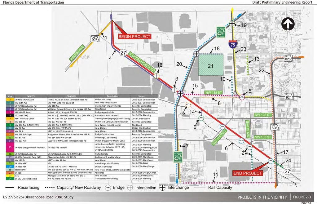
20
21 3 EXISTING CONDITIONS & EVALUATION The methodology employed for the existing conditions and evaluation performed for the Okeechobee Road facility consisted of three basic phases. Figure 3-1 contains a flowchart detailing the process utilized for this project. The phase descriptions are as follows: Figure 3-1 Existing Conditions and Evaluation Analysis Flowchart 3.1 Phase I Data Gathering Phase This first phase included the collection and review of all data pertaining to the existing facility. The task involved an on-site inventory and verification of current existing conditions as well as the collection of all pertinent data that would serve as the basis for evaluation. Other important project features along the Okeechobee Road facility such as traffic, safety as well as the existing social/environmental characteristics were reviewed and summarized. Due to recent transportation studies, which contained portions of the facilities under study, the extensive review of all applicable reports was an important component of this phase. Appendix A of this report contains a list of references of previous study reports and other pertinent documents that were consulted during this task Roadway/Structural Characteristics Typical Sections and Functional Classifications Within the limits of the project, Okeechobee Road has been designated a SIS facility as well as a primary evacuation route for Miami-Dade County and serves as a restrictive highway due to the lack of access points and the presence of a frontage road. Okeechobee Road generally features two distinct typical sections, as shown on Figure 3-2. From the begin project at Krome Avenue to the SR 821/HEFT interchange, Okeechobee Road features two directional 12-foot lanes with 8-foot inside shoulders (4-foot paved), and 12-foot outside shoulders (4-foot paved). A grass median varying from 60 feet to 130 feet in width separates the eastbound and westbound traffic. Just north of the facility an intermittent east-west Frontage Road serves the mobility and access needs of several abutting land uses, while on the south side the Miami Canal borders the project area. In general terms, this segment of Okeechobee Road is functionally classified as a divided rural principal arterial, Access Class 2. The second project segment extends from the intersection with the HEFT until the project s eastern terminus at NW 79 th Avenue. It s functional classification is a divided urban principal arterial, Access Class 2. This typical section features three directional 12- foot lanes with 8-foot inside shoulders (4-foot paved) and 10-foot paved outside shoulders. A 42- foot wide grass median separates the eastbound and westbound traffic. A two-lane, two-way Frontage Road runs along the north side of Okeechobee Road from just west of NW 138 th Street to west of SR 826 and serves the access and mobility needs of many land uses just north of the Existing Conditions & Evaluation Draft Preliminary Engineering Report 3-1

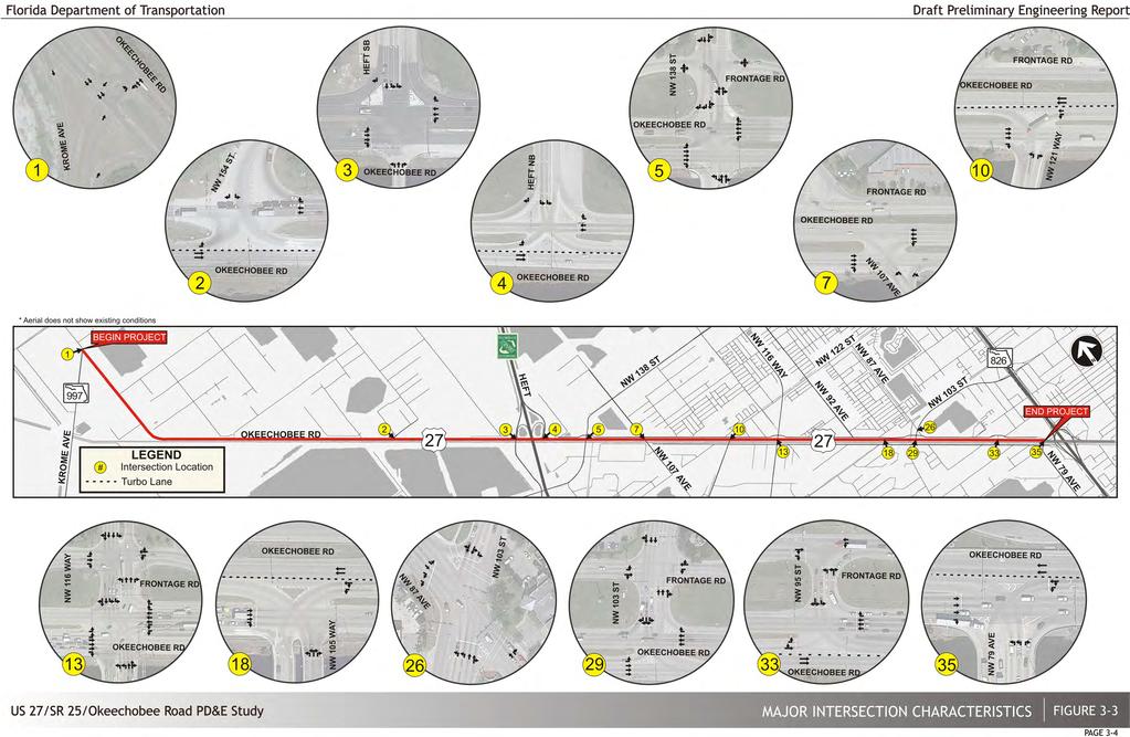
22 Figure 3-2 Existing Typical Sections project area (City of Hialeah Gardens and City of Hialeah). Along the south side of Okeechobee Road the Miami Canal and NW S River Drive abutt the project area which serves the access and mobility needs of the industrial land uses in the Town of Medley. Table 3-1 describes the characteristics of the major terminal or roadway crossings within the project area. Table 3-1 Existing Characteristics of Major Facilities along the Project Corridor Facility Name SR 997/ Krome Ave. SR 821/HEFT NW 138 th St. NW 107 th Ave. NW 121 st Way NW 116 th Way NW 105 th Way NW 103 rd St. Functional Classification Rural Principal Arterial Urban Other Freeway/ Expressway Collector Collector Local Road Minor Arterial Local Road Major Arterial Number of Lanes Typically 2 lanes Typically 6 lanes 4 lanes NE of Okeechobee, 2 lanes SW of Okeechobee 2 lanes south of Okeechobee, 4 lanes north of Frontage Road 2 lanes 4 lanes NE of Okeechobee, 6 lanes SW of Okeechobee 4 lanes typical, 6 lanes at intersection 5 lanes at intersection NW 95 th St. Local Road 4 lanes NW 79 th St. Collector 6 lanes Directional Operation Two way north-south traffic Two way north-south traffic Two way traffic Two way north-south traffic Two way north-south traffic Two way north-south traffic Two way north-south traffic Two way NE- SW traffic Two way traffic, NE- SW traffic Two way NE- SW traffic Median Type Divided sod median Divided traffic railing Divided NE of Okeechobee; undivided SW of Okeechobee Divided sod, north of Frontage Rd undivided south Undivided Divided sod median Divided Divided with raised curb Undivided Divided with raised curb Remarks SR 997/Krome Ave. terminates at intersection with Okeechobee Road. Full Interchange provides NB/SB HEFT access along Okeechobee Road. NW 138 St. intersects Okeechobee Road at a four way intersection. Provides access to I-75 and SR 924 to the north/east. Provides connection to Okeechobee Road from the south only. Continues from Frontage Road to the north. Intersection contains turbo lanes for the WB traffic along Okeechobee Road. Provides connection to Okeechobee Road from the south only. Crosses Okeechobee Road with a four legged intersection. Provides access to I- 75, SR 924 to the north/east, and to the HEFT via Gran Park. Intersection contains two turbo lanes for SE bound traffic. Provides connection to Okeechobee Road from the south only. Provides access to HEFT to the south/west. Provides connection to Okeechobee Road from the north only. Provides access to SR 826 to the east. Provides connection to Okeechobee Road from the north only. Intersection provides two turbo lanes for SE bound traffic. Provides connection to Okeechobee Road from the south only. Intersection provides two turbo lanes for NW bound traffic. l Existing Conditions & Evaluation Draft Preliminary Engineering Report 3-2
23 Posted Speed The posted speed along Okeechobee Road is 55 miles per hour (mph) from Krome Avenue to NW 117 th Avenue and 50 mph to NW 79 th Avenue. It should be noted that the speed limit is 65 mph just north of Krome Avenue. Along the Frontage Road the posted speed is 40 mph with a reduced speed of 25 mph at the curves approaching the intersections Right-of-Way The existing R/W along Okeechobee Road varies throughout the project corridor. Frontage Road is part of the FDOT R/W from west of NW 138 th Street to west of NW 79 th Avenue; along the western segment of the project, Frontage Road is discontinuous with portions not within the FDOT R/W. From Krome Avenue to NW 170 th Street the R/W varies from approximately 260 to 380 feet; from NW 170 th Street to the HEFT the R/W is approximately 220 feet; from the HEFT to NW 79 th Avenue the R/W is generally 260 feet along most of the corridor, except at the intersections where Frontage Road separates from the mainline and the R/W increases to about 350 feet Intersections and Signalization There are 12 signalized intersections along Okeechobee Road within the limits of the project. Additionally, there are five (5) signalized intersections along Frontage Road and four (4) along NW S River Drive. Traffic signal locations on intersecting streets are at Krome Avenue, NW 154 th Street, the HEFT Interchanges (2), NW 138 th Street, NW 107 th Avenue, NW 121 st Way, NW 116 th Way, NW 105 th Way, NW 103 rd Street, NW 95 th Street and NW 79 th Avenue. Figure 3-3 provides the lane configuration at each major signalized intersection. Table 3-2 presents the existing geometric characteristics. All existing intersections were field verified to reflect the latest lane configuration. As shown in the figure, many of the existing problems in the project corridor stem from the close proximity of signalized intersections at cross streets due to closely spaced parallel facilities (i.e. NW S River Drive, Okeechobee Road and Frontage Road) which results in insufficient storage at the intersections. Additionally, the intersections do not have the sufficient turning radii for large trucks. ID Intersection Table 3-2 Existing Lane Configuration Movement EB WB NB SB L T R L T R L T R L T R 1 SR 25/Okeechobee Rd & Krome Ave 0 2 1^ ^ SR 25/Okeechobee Rd & NW 154 th St ^ SR 25/Okeechobee Rd & HEFT SB ^ ^ 4 SR 25/Okeechobee Rd & HEFT NB 1 2^^ ^ ^ 5 SR 25/Okeechobee Rd & NW 138 th St 1 3 1^ <2> 0 0 <1 2 6 NW 138 th St & Frontage Rd 0 <1> 0 0 <1> 0 0 <2> 0 0 <2 1 7 SR 25/Okeechobee Rd & NW 107 th Ave 0 3 1^ 1 3^^ NW S River Dr & NW 127 th St 0 1> 0 0 <1 0 1> NW S River Dr & NW 122 nd St 0 1> SR 25/Okeechobee Rd & NW 121 st Way 0 3 1^ 1 3^^ NW S River Dr & 121 st Way 0 <1> 0 1 1> 0 0 <2> 0 0 < Frontage Rd & NW 116 th Way > > 0 13 SR 25/Okeechobee Rd & NW 116 th Way ^ 2 2> 0 2 2> 0 14 NW S River Dr & NW 116 th Way 1 1> 0 1 1> 1 1 3> 0 1 2> 0 15 NW 122 nd St & NW 92 nd Ave 1 2> 0 1 2> <1> 0 16 Frontage Rd & NW 92 nd Ave Frontage Rd & NW 107 th St ^ SR 25/Okeechobee Rd & NW 105 th Way <3^^ 0 1 <1> NW S River Dr & NW 106 th St 0 1> NW S River Dr & NW 105 th Way 0 <1> 0 0 <1 1 0 <2> 0 1 2> 0 21 NW 106 th St & NW 95 th Ave 0 <1> 0 0 <1> 0 1 1> 0 0 <1> 0 22 NW 114 th St & NW 87 th Ave 1 <1 1 1 < > 0 1 2> 0 23 NW 106 th St & NW 82 nd Ave 0 <1> 0 0 <1> 0 0 <2> 0 1 2> 0 24 NW 103 rd St & NW 82 nd Ave 0 <1> 0 0 <1> 0 0 <2> 0 1 2> 0 25 NW 106 th St & NW 87 th Ave <1> 0 0 2> NW 103 rd St & NW 87 th Ave 2 2> 0 1 2> 0 0 2> Frontage Rd & NW 103 rd St 1 1> 0 1 1> 0 0 3> 0 0 3> 0 28 Frontage Rd & NW 87 th Ave > SR 25/Okeechobee Rd & NW 103 rd St ^ <1> 1 30 NW S River Dr & NW 87 th Ave 0 1> 0 0 <1 0 0 <1> NW 96 th St & NW 87 th Ave ^ ^ Frontage Rd & NW 95 th St Connector 0 1> <1> SR 25/Okeechobee Rd & NW 95 th St 1 <3^^ <1> 0 34 Frontage Rd & NW 95 th St 0 < > SR 25/Okeechobee Rd & NW 79 th Ave <3^^ ^ NW S River Dr & NW 79 th Ave 0 <2> 0 1 1> 0 1 2> 0 1 2> 0 LEGEND > Shared thru and right turn lane < Shared thru and left turn lane Intersection aerials shown in Figure 3-3 ^ Right turn free flow lane provided ^^ Turbo lane Existing Conditions & Evaluation Draft Preliminary Engineering Report 3-3
24
25 Existing Interchanges The only major interchange within the project limits is the SR 821/HEFT Interchange located just west of the Okeechobee Road/NW 138 th Street intersection. This service interchange has a half cloverleaf configuration with on and off ramps in the northeast and northwest quadrant. It should be noted that Florida's Turnpike Enterprise (FTE) is currently planning to widen the HEFT from NW 106 th Street to I-75 (FPN ) from six to ten lanes in Fiscal Year These improvements include the reconfiguration of the HEFT/Okeechobee Road interchange to include a northbound to eastbound off ramp and a eastbound to southbound on ramp. The SR 826/Palmetto Expressway full diamond/semidirectional interchange connecting to both Okeechobee Road and NW S River Drive is located east of NW 79 th Avenue, just east of the project s eastern limits Horizontal and Vertical Alignment In general terms, the project horizontal alignment is generally composed of a series of tangent sections with relatively small deflection angles or relatively flat curves. There is only one location with a significant horizontal curve located approximately one mile east of the project beginning at the Krome Avenue intersection (see section for more information). In general terms, the existing facility exhibits a series of very long flat grades with no existing vertical curves. Horizontal and vertical clearances for the existing bridges were obtained from the existing bridge plans and are tabulated in Figure 3-4. Information was not available for the NW 121 st Way and NW 118 th Avenue bridges. In a letter dated November 12, 2012 from the South Florida Water Management District (SFWMD), the required minimum vertical clearance at the bridge locations was noted to be 2 feet of clearance above the Design Water Surface Elevation (DWSE) of 4.95 (NAVD88) or 6 feet above the Optimum Water Surface Elevation (OWSE) of 0.95 (NAVD88), whichever produces the higher elevation. For all the bridges with available information, the existing minimum vertical clearances meet the requirements of SFWMD. For the HEFT bridges over Okeechobee Road, the current minimum vertical clearance is 16.3 feet Lighting The existing Okeechobee Road corridor has conventional cobra head luminaires mounted on steel poles lighting system spaced approximately 280 feet apart. From Krome Avenue to the HEFT standard light poles are provided on the outside shoulder along both sides of the facility. From the HEFT to NW 79 th Avenue standard poles are provided along the eastbound shoulder and double arm light poles are provided along the westbound shoulder to provide lighting for both Okeechobee Road and the Frontage Road. The roadway lighting is maintained by the FDOT under a maintenance contract Existing Bridges/Structures There are a total of ten (10) bridges within the project limits consisting of eight (8) canal bridge crossings and two (2) grade separated bridges. The canal crossings are low level bridges spanning the Miami Canal and their superstructures consist of either reinforced concrete flat slab or precast slab units with the exception of the NW 107 th Avenue bridge which consists of AASHTO Type II beams. The HEFT bridges over Okeechobee Road are the only grade separated structures within the project limits and these bridges consist of AASHTO Type II and III beams. The substructure for all the canal crossings consists of pile bents with square prestressed concrete piles. The substructure for the HEFT bridges consists of both multi-column piers with round columns and prestressed concrete pile bents. The pile bents for the HEFT bridges are located adjacent to the Miami Canal. The bridge characteristics including location, structure type, geometrics, condition and historical significance was collected and analyzed for each structure and summarized in Figure 3-4. Information for the NW 118 th Way Bridge over Miami Canal was not available. It should be noted that the proposed bridge over the Miami Canal at NW 87 th Avenue is anticipated to be completed by FY Structures Condition Figure 3-4 provides a summary of the condition of the existing bridges within the project area. All the traffic railings meet current standards with the exception of the traffic railing located on the west side of the NW 116 th Way Bridge (Bridge No ). Most of the canal crossings have extensive damage to the existing bridge railings due to the substandard curve returns at the bridge ends. Also, most of the bridges do not have the thrie beam attachment to the bridge ends and in some cases, there is no attachment at all. At the HEFT bridges over Okeechobee Road, the guardrail offset to the existing bridge columns do not meet the required minimum offset as per PPM Table The existing columns are also within the setback distance of 30 feet and will require pier Existing Conditions & Evaluation Draft Preliminary Engineering Report 3-5
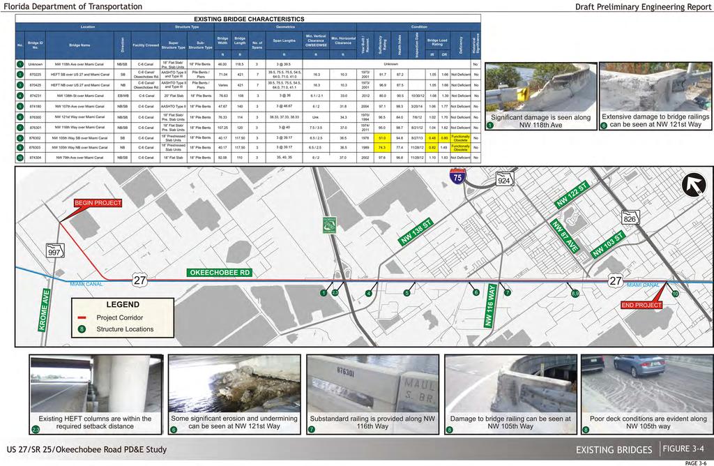
26
27 protection barriers, especially within this high speed corridor and heavy truck traffic. There also signs of impact to the existing beams on both sides of the bridges. As part of the National Bridge Inventory and Structural Inventory and Appraisal program conducted by the FHWA, FDOT requires biannual evaluations of all bridges under its jurisdiction. Inspection results based on the latest Bridge Inspection Reports are shown in Figure 3-4. All of the bridges with the exception of the NW 105 th Way bridges have very high sufficiency ratings ranging from 80.0 to These sufficiency rating values typically mean that the bridges are candidates for rehabilitation/widening and not replacement. The NW 105 th Way bridges have sufficiency ratings of 51.0 and 74.3 and are considered functionally obsolete. Under the current FDOT Bridge Load rating process for widening of existing bridges, load ratings performed using an older method, such as the Load Factor Rating method (LFR), require a new load rating utilizing the Load and Resistance Factor Rating method (LRFR). If the new LRFR ratings do not produce an acceptable Inventory rating (IR) or any FL120 Permit rating factors rating greater than 1.0, rating factors using the LFR method may be used. FDOT Structures Manual Volume 1 Structures Design Guidelines (SDG), Figure requires a LRFR exceeding 1.0 for Inventory and FL120 Permit load. If not, the Inventory rating based on LFR needs to exceed 1.0. If the LFR inventory rating factors are less than 1.0, replacement or strengthening is required unless a Design Variation is approved. The Inventory Rating (IR) factor represents loads which can safely utilize an existing structure for an indefinite period of time. The Operating rating (OR) factor represents the maximum permissible live load to which the structure may be subjected. As shown in Figure 3-4, the Inventory and Operating ratings are satisfactory for all the bridges with ratings greater than 1.0, except for the NW 105 th Way bridges. The NW 107 th Avenue Bridge (Bridge No ) over the Miami Canal has conflicting historical information pertaining to the Design vehicle and the load rating vehicle. According to the existing bridge plans and Bridge Inspection Report, the design vehicle for the bridge is an HS25 vehicle, as opposed to the standard HS20, which can be attributed to the 30% truck traffic of the Average Daily Truck (ADT) traffic that uses the bridge. The Load Rating analysis obtained from FDOT was performed on May 3, 2004 states that the load rating was performed with an HS20 truck vehicle which produced an Inventory rating (the capacity of the bridge as reported by BARS) of 38.2 Tons. Typically, the design vehicle and the load rating vehicle should be the same. Although the load rating (based on the HS20 vehicle) reported an Inventory rating factor greater than 1.0, if the load ratings are computed based on the design vehicle (HS25 as stated in the existing plans, Bridge Inspection Report dated 3/15/2012 and FDOT Load Rating), the LFR Inventory rating factor would not be acceptable. In consultation with FDOT D6 Structures, FDOT suggested the following approach during final design of the NW 107 th Avenue bridge: 1. An LRFR rating should be performed utilizing an HL-93 vehicle without the 1.25 multiplier for the heavier truck. If this results in an acceptable LRFR rating, the design vehicle can be assumed to be the HL-93 vehicle. 2. If the above results in an unacceptable LRFR rating, an LFR rating per Section 7.1 of the SDG would need to be performed utilizing the HS25 vehicle. If this results in acceptable load rating factors, then the design vehicle can be assumed to be the HS25 vehicle. 3. If the above results in an unacceptable LFR rating, then an LFR with an HS20 vehicle load rating will need to be performed. Since this is similar to the load rating dated previously done, it is not expected to produce unacceptable rating values, thus the design vehicle can be assumed to be the HS20 vehicle. All of the bridges with available information are suitable for potential widening/retrofitting with the exception of the NW 105 th Way bridges which have low sufficiency ratings, unsatisfactory load ratings and are classified as functionally obsolete. Replacement of the NW 105 th Way bridges is recommended Transit Facilities Within the footprint of Okeechobee Road, Frontage Road, and NW S River Drive, Miami-Dade Transit (MDT) and Hialeah Transit are the two transit systems supporting regional connectivity to the nearby destinations. Existing Conditions & Evaluation Draft Preliminary Engineering Report 3-7

28 Wheelchair Accessible/Bike Accessible Route/Metrorail Transfer Route Metrobus Route 33 is the only MDT route that has service within the project limits. Route 33 serves a short portion of the project area traversing NW 103 rd Street along the north side of Okeechobee Road and a short segment of NW 105 th Way along the southside of the facility. Top Service Destinations on the route include NW 106 th Street/NW S River Drive, Lehigh Industrial Park, City of Hialeah Gardens City Hall, City of Hialeah, Westland Mall, West/East 49 th Street (NW 103 rd Street), NW/NE 95 th Street, North Shore Hospital, and Miami Shores Village. Route 33 Operates Monday to Sunday from approximately 5:30 AM to 11:00 PM with 15 to 30 minute headways. Route 33 has an average weekday boarding of 2,234 passengers and an average monthly boarding of 55,063 passengers. The nearest Metrorail station to the project limits is the Palmetto Station located at 7701 NW 79 th Avenue Medley, FL Metrobus Route 33 does not stop at the Metrorail Palmetto Station; however other Metrobus routes that have a connection to Route 33 east of the project limits could serve as transfer routes to the Palmetto Station. Hialeah Transit Services operates throughout the cities of Hialeah and Hialeah Gardens. Hialeah Transit provides two fixed route bus service, the Marlin Route and the Flamingo route, for areas of interest throughout the cities such as work, schools, hospitals shopping, libraries, parks, and cultural and civic activities. Service for Hialeah Transit runs from 6:00 AM to 7:30 PM on weekdays, 9:00 AM to 3:30 PM on Saturdays with no service on Sunday. Holiday hours are from 9:00 AM to 3:30 PM. The routes have no scheduled stops or time points and buses travel along the routes throughout the day. Hialeah Transit states that the routes have approximately 45 minute headways throughout the day. The Marlin Route connects the area adjacent to LeJeune Road (East 8 th Avenue) on the east with NW 107 th Avenue just north of Okeechobee Road on the west. Within the project vicinity, this route traverses a portion of the Frontage Road. There are several bus stops for this route in the immediate vicinity of the project including at - BJ s Wholesale Stop at NW 95 th Street, Vista Del Lago Condo Stop at Frontage Road, Hialeah Gardens City Hall Stop at NW 103 rd Street, Courtly Manor Trailer Homes Stop at Frontage Road, and El Jardin Shopping Center Stop at Frontage Road. All bus stops on Frontage Road are located on the northbound side of the road with no stops on southbound side. Service to bus stops on Frontage Road may be impacted by proposed improvements during construction. It is anticipated that Miami-Dade County will pursue joint development opportunities at multiple Metrorail stations, including the future Palmetto Intermodal Terminal at the existing Metrorail Palmetto Station. The 2023 Recommended Service Plan of the Miami-Dade Transit Development Plan provided that 13 transit hubs were proposed for implementation in locations throughout Miami-Dade County. As a result, these new terminals would serve local corridors and stations, while also providing connecting service to transit hubs. Within the study area, the new Palmetto Express Bus would run to the Palmetto Intermodal Terminal. No other future services are identified along the Okeechobee Road PD&E Study limits as planned services in the Miami-Dade Transit Development Plan or from coordination with the City of Hialeah Pedestrian and Bicycle Facilities A recently completed Resurfacing, Restoration and Rehabilitation (RRR) project from NW 117 th Avenue to the Miami-Dade county line (FM # ) provided designated bike lanes for one (1) mile at each end of the RRR project limits. There are no other pedestrian or bicycle facilities present along Okeechobee Road within the study limits. However, many bicyclists have been observed on Okeechobee Road, especially in the early morning. There are discontinuous sidewalks along the north side of frontage road for small segments within the limits of the project. No designated bicycle lanes are provided along the frontage road. As mentioned in section , Existing Conditions & Evaluation Draft Preliminary Engineering Report 3-8
29 the Hialeah Transit Marlin route has a number of bus stops along Frontage Road that have inadequate pedestrian connectivity. Utility & Contact Information Description Table 3-3 Existing Utilities Remarks Utilities Utility companies with known facilities within the proposed project limits were contacted and requested to submit as-built plans, and all proposed utilities within the project limits. Table 3-3 presents a list of utilities. The following utility information was compiled from utility responses received. Utility & Contact Information Comcast Cable Leonard Maxwell-Newbold (954) City of Hialeah Gardens Water & Sewer Andres Delgado (305) Florida City Gas Dexter Pinkney (305) City of Hialeah Department of Water & Sewer Jose Rodriguez (305) Miami-Dade County Public Works Aurelio Del Valle (305) Fiberlight, LLC Chris Pancione (954) Description Aerial Fiber Lines Underground Coaxial Lines Table 3-3 Existing Utilities Remarks Frontage Road: STA 225 to STA 230, STA 295 to STA 386 NW 122 nd Street: Frontage Road to the end of project (east of SR 826 / Palmetto) NW 103 rd Street: US 27/Okeechobee Road to NW 87 th Avenue NW 87 th Avenue: NW 103 rd Street to end of project NW 105 th Way: Perpendicular to US 27/Okeechobee Road at approx STA 310 NW S River Drive: STA 295 STA 310 NW 106 th Street: NW S River Drive to end of project Okeechobee Road: Perpendicular to Okeechobee Road at STA 209 Water Line Okeechobee Road: STA 153 to STA 388 Okeechobee Road: STA 170 to STA 183, STA 329 to STA 360 NW 87 th Avenue: STA 297 to Frontage Road Sewer Line Frontage Road: STA 328 to STA 360 NW 98 th Street: STA 356 to STA 360 Okeechobee Rd: perpendicular to Okeechobee Rd at STA 221, STA 391 to end of project NW 121 st Way: STA 221 to NW S River Drive Gas Line Frontage Road: STA 330 to STA 357 (2", 4", 6") NW 98 th Street: perpendicular to Okeechobee Road at STA 221, STA 221 to 232 along Okeechobee Road then along NW 98 th Street STA 232 NW S River Drive: STA 216 to STA 242 Water and Sewer Line Sanitary Force Main (24") Underground Fiber Optics Lines NW 103 rd Street: NW 87 th Avenue to end of project Frontage Road: STA 326 to STA 350 Okeechobee Road: STA 390 to the end of project (east of SR 826/Palmetto), perpendicular to Okeechobee Road at STA 227 Okeechobee Road: Perpendicular to Okeechobee Road at STA 257 Okeechobee Road: STA 326 to STA 366 NW 89 th Avenue: STA 324 runs perpendicular to Okeechobee Road NW 95 th Street: STA 366 perpendicular to Okeechobee Road to the end of project along NW 95 th Street Florida Department of Transportation, District 6 Thomas Miller (305) Florida Gas Transmission Company Joseph Sanchez (407) ATT/Distribution Otis Keeve (954) Systems Integration & Maintenance, Inc. Michael Collier (305) Florida Power & Light Tracy Stern (800) FPL Fibernet, LLC Danny Haskett (305) ITS Infrastructure Natural Gas Transmission Pipeline 24" O.D. x 0.406" W.T. Overhead Lines Underground Lines Florida's Turnpike Enterprise ITS Maintenance Overhead Distribution Lines Underground Distribution Lines TX Line (230kV) Underground Fiber Optic Lines No existing ITS Infrastructures within the limits of the project Existing ITS system along SR 826 and Florida's Turnpike Okeechobee Road: Perpendicular to Okeechobee Road at STA 386 Frontage Road: STA 725 to STA 132, Okeechobee Road: Runs perpendicular at STA 132, STA 137, STA 230, and STA 559 Frontage Road: STA 137 to STA 269, STA 279 to STA 288, STA 309 to STA 320, NW 87 th Ave: STA 327 to Frontage Road STA 386 Okeechobee Road: STA 132 to STA 137, STA 392 to 395 Frontage Road: STA 269 to STA 271, STA 271 to NW 114 th Street, STA 275 to STA 279, STA 288 to STA 309, STA 320 to STA 326, STA 326 to NW 103 rd Street No existing ITS Infrastructures within the limits of the project Existing ITS system along SR 826 Existing ITS along HEFT Okeechobee Road: NW 186 th Street to STA 389, perpendicular to Okeechobee Road at STA 317, perpendicular to Okeechobee Road at STA 385, and STA 142 to end of project (east of SR 826/Palmetto North) NW 107 th Avenue: runs perpendicular to Okeechobee Road at STA 189 NW 116 th Way: runs perpendicular to Okeechobee Road at STA 257 NW 89 th Ave: perpendicular to Okeechobee Road at STA 324 and runs along NW 87 th Ave HEFT: South Bound on Ramp to North Bound Off Ramp Frontage Road: STA 479 to STA 189, STA 165 to NW 138th St STA 160, STA 184 to 230, STA 220 to STA 388 Okeechobee Road: STA 142 to STA 184, perpendicular to Okeechobee Road at STA 386 NW S River Drive: STA 184 to STA 388 NW 122 nd Street: perpendicular to Okeechobee Road at STA 184 to STA 229 NW 107 th Avenue: runs perpendicular to Okeechobee Road STA 189 Okeechobee Road: perpendicular to Okeechobee Road at STA 385 and STA 384. Along the cross streets: NW 138 Street, NW 106 Street and NW 87 Avenue Along Frontage Road from NW 87 Avenue to SR 826 Along NW S River Drive from NW 109 Street, and continues south of SR 826 Existing Conditions & Evaluation Draft Preliminary Engineering Report 3-9
30 Utility & Contact Information Level 3 Communications, LLC Judy Henry (720) Town of Medley Utilities Department Walter Wernke (305) Description Table 3-3 Existing Utilities Remarks Underground Lines ( " HDPE Okeechobee Road: STA 725 to end of project (east of the SE 826/Palmetto) Conduits FOC 96) Underground Lines Okeechobee Road: STA 725 to STA 763, perpendicular to Okeechobee Road at STA 763, STA 763 (2-1.5" HDPE to STA 189, STA 725 to STA 385 end of project conduits and NW 107 th Avenue: STA 189 to NW 107 th Court " HDPE FOC NW 103 rd Street: NW 89 th Avenue runs perpendicular to Okeechobee Road at STA 325 then runs 144) along NW 103 rd Street NW South River Dr: Runs parallel along NW South River Drive from STA 168 to STA Water Main NW 138 St: Along NW 138 Ave, perpendicular to Okeechobee Road starting from Miami (C-6) Canal to end of project NW 107 Court: Runs parallel along NW 107 th Court from NW South River Drive to end of project limits NW 127 th Street: STA 190 to STA 200 NW 122 nd Street: From NW South River Drive to end of project limits 16 Water Main NW 116 th Way: Runs parallel to NW 116 th Way from Frontage Road to end of project limits NW 105 th Way: From Okeechobee Road to end of project limits NW 87 th Avenue: From NW South River Drive to end of project limits NW 89 th Avenue: NW 97 th Terrace to NW 93 rd Street NW 93 rd Street: NW 89 th Avenue to end of project NW South River Drive: Runs parallel along NW South River Drive from STA 191 to end of project 20 Water Main NW 107 th Avenue: From NW South River Drive to end of project limits NW South River Drive: Runs parallel along NW South River Drive from STA 168 to STA 183, STA 200 to Hialeah Gardens Blvd, and STA 314 to STA 389 NW 116 th Way: Runs perpendicular to Okeechobee Road from NW South River Drive to end of project. 8 Gravity Sewer NW 127 th Street: NW 107 th Court to NW 107 th Avenue Line NW 107 th Avenue: Runs parallel from NW 127 th Street to end of project NW 121 Way: Runs parallel along NW 121 Way from NW South River Drive to end of project limits NW 87 th Avenue: From 200 feet south of NW South River Drive to end of project NW 93 rd Street: NW 89 th Avenue to end of project NW 89 th Avenue: NW 97 th Terrace to end of project NW 113 th Avenue Road: Runs parallel from STA 156 to STA FM DIP NW 127 th Street: Runs parallel from STA 191 to STA 200. NW South River Drive: From STA 231 to STA 270, and STA 310 to STA FM DIP NW 105 th Way: NW South River Drive to 150 feet south of NW 105 th Way NW 89 th Avenue: NW 97 th Terrace to NW 96 th Street 16 FM DIP NW South River Drive: From STA 270 to STA 301, and STA 330 to end of project. Lanes project will increase the FDOT fiber optic cable to 144 strand fiber optic cable. This existing FDOT ITS system is currently monitored, and managed from the FDOT District Six Regional Transportation Management Center (RTMC) using SunGuide software. At the interchange of SR 826 and Okeechobee Road there is an existing CCTV camera on the northeast corner that could be utilized to connect the new system to the District Six RTMC. The connection could be done via fiber optic cable or via a wireless system. As mentioned previously, the I-75 Express Lanes project will potentially impact the existing ITS system along the SR 826; therefore during design phase of the Okeechobee ITS network, the Engineer is to verify and assess the appropriate connectivity method of integration with the existing Sunguide network. Within the project limits, at the interchange of SR 821 and Okeechobee Road, there is one existing CCTV camera located on the northwest corner that belongs to the Florida s Turnpike Enterprise (FTE). Also as part of the Turnpike s network, two existing Arterial Dynamic Message Sign (ADMS) have been installed on Okeechobee Road and are connected via a wireless link. These ADMS are installed on both approaches to SR Soils The Soil Survey of Miami-Dade County, Florida published by the United States Department of Agriculture (USDA) Natural Resources Conservation Service (NRCS) was reviewed for general near-surface soil information in the project area (Figure 3-5). It should be noted that the spacial version was last updated by NRCS in February This information indicates that there are a total of 6 primary mapping soil units within the study area. Table 3-4 summarizes the general surface soils encountered within the project limits. The environmental classification per existing bridge plans is limited to non-coastal which is Intelligent Transportation System (ITS) Features Currently, within the study limits, the US 27/SR 25/Okeechobee Road corridor has no ITS infrastructure that belongs to FDOT. However, just east of the project limits, the FDOT has an existing ITS system composed of seventy-two strand fiber optic backbone, Closed Circuit interpreted as either a slightly or moderately aggressive environment. Based on environmental corrosion test results on the water samples from the Miami Canal, the environmental classifications per the FDOT Structures Design Guidelines are as follows: Superstructure = Slightly Aggressive, Substructure = Moderately Aggressive for both steel and concrete. Television (CCTV) cameras, Microwave Vehicle Detection Sensors (MVDS), Dynamic Message Signs (DMS) and other equipment along SR 826. It should be noted that the Palmetto-I 75 Express Existing Conditions & Evaluation Draft Preliminary Engineering Report 3-10
31 Mapping Soil Unit Number Table 3-4 Preliminary Soil Survey Mapping Soil Unit Name Percent of Area West East 2 Lauderhill Muck Depressional 34.2% 11% 9 Udorthents-Water Complex 3.1% 25.4% 10 Udorthents, Limestone Substratum- Urban Land Complex % 14 Dania Muck, Depressional 58.6% 13.3% 15 Urban Land 2.4% 28.9% 99 Water 1.7% 4.8% Subsurface conditions along the projet corridor were explored by a total of 40 auger boring, foot Standard Penetration Test (SPT) borings and three 100-foot SPT borings. The stratum number and soil types encountered are listed in Table 3-5. Additional information can be found in the Preliminary Roadway Soil Survey Report and Preliminary Geotechnical Report for Bridges prepared for this project (December 2013). The 100-foot SPT borings shows soil capacities ranging from tons for 18 inch square piles and from tons for 24 inch square piles with the highest capacities near NW 116 th Way and the lowest capacities at NW 79 th Avenue. Stratum Number Typical Soil Description 1 Topsoil 1a Asphalt Light brown/brown sand with limerock, mostly fill Brown/light brown silty sand, occasionally with trace organics Brown very silty sand to sandy silt Light gray/gray sandy limestone Dark brown organic silty sand to muck Drainage Table 3-5 General Soil Condition AASHTO A-8 - A-1-b A-2-4 FDOT Soil Designation Unsuitable - Select Select Suitability/ Recommendations To be removed by clearing and grubbing FDOT Standard Specs 110 To be removed by clearing and grubbing FDOT Standard Specs 110 Suitable for subgrade and embankment FDOT Index 505 Suitable for subgrade and embankment FDOT Index 505 A-4 Plastic Found in 3 borings. Remove and replace- FDOT index 500. Further evaluation needed - - Can be used if satisfied FDOT standards A-8 Unsuitable Found in 14 borings. Remove and replace- FDOT index 500. Further evaluation needed The project is located in the South Florida Water Management District (SFWMD) C-6 (Miami Canal) and "C-9 (Snake Creek)" Basins. The Snake Creek Basin is located in northern end of Miami-Dade County and southern end of Broward County and flows to the east discharging via S-29 to Dumbfoundling Bay. The western subbasin is very prone to flooding due to low ground surface elevations. The C-6 Basin includes the areas around the Miami River, from the Everglades to the Bay. The Miami Canal immediately abuts the project area to the south and flows from Lake Okeechobee to its terminus at the Miami River and into Biscayne Bay. Within the project area, the existing drainage for the project area was divided into eight main drainage basins and various sub basins. Okeechobee Road was constructed on the levee resulting from the construction of the Miami Canal. As a result Okeechobee Road is set above the base flood elevation that ranges from 6.00 feet to 7.00 feet NGVD for areas south of NW 170 th Street which is also the limit between the Miami Canal and the Snake Creek West regional drainage basin. North of NW 170 th Street the surrounding area gently slopes down to elevation 3.00 feet NGVD and the base flood elevation varies from 3.00 feet to 4.00 feet NGVD. Figure 3-6 shows the existing project drainage areas and their characteristics. In general terms most of the existing drainage is characterized by a system of drains and cross drains in combination with the ditches which outfall to the local drainage canals network or directly into the Miami canal. Within the project limits, there are a total of 48 cross drains discharging to the Miami Canal. A major cross drain is located west of the intersection of NW 103 rd Street and Frontage Road near NW 87 th Avenue. It is a 15 diameter corrugated metal pipe (CMP) cross drain that connects the C-6 Canal (Miami Canal) to the C-7 canal. Upstream of the existing 15 feet CMP cross drain there is an existing SFWMD C-7 canal control structure, located beneath NW 87 th Avenue and where the C-7 canal bends and connects to the 103 rd Street canal which is a tributary of the C-6 Spurs canal. This control structure is known as G-72 and consists of four 72 inch corrugated parallel metal pipes each approximately 75 feet long. These pipes are fitted with manually operated stop logs located in CMP riser pipes on the west end of the culvert. The function of the structure is to open it only when supplemental water is needed in the C-7 canal to maintain optimum ground water levels during the dry season that normally runs from November to April. It is normally closed, and does not serve any flood conveyance purpose. Its location is at the confluence of the C-7 and C-6 basins.there is no history of flooding reported; however, it should be noted that signs of ponding were observed along multiple segments of Frontage Road. No signs of drainage deficiencies have been noted along Okeechobee Road. Existing Conditions & Evaluation Draft Preliminary Engineering Report 3-11
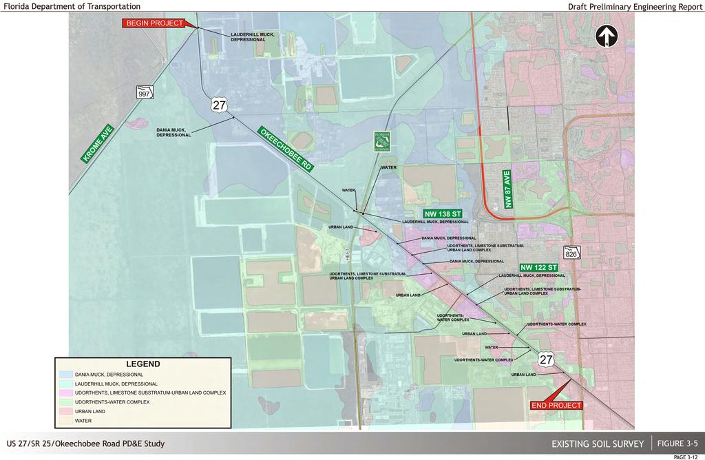
32
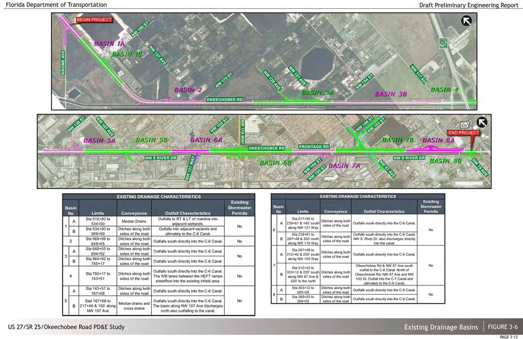
33

34 3.1.8 Existing Traffic Conditions Field Observations Summary Field observations were made by qualified personnel covering weekdays during the morning peak period between 7:00 AM and 9:00 AM and during the afternoon peak period from 4:00 PM to 6:00 PM. As previously stated, the western project segment extending from the Krome Avenue intersection to the HEFT interchange is mostly rural in nature and does not exhibit any significant capacity concerns. Many safety problems associated with this rural segment of the project are due to a combination of large speed differentials involving ingress and egress movements of the high volume of trucks coupled with the insufficient length of existing auxilary lanes. Within this area, there is a significant variation in the directional traffic distribution with much higher eastbound traffic volumes present during the morning peak and the reverse occurring during the afternoon peak It should be noted that although this general trend continues in the eastern project segment (east of the HEFT interchange); the directional differences between the eastbound and westbound traffic are not quite as significant (except in the immediate vicinity of the SR 826 interchange). Figure 3-7 provides additional key findings and reflect the locations that in general are experiencing most of the significant delays and related congestion Data Collection As part of this study, vehicular traffic data was obtained from field counts as well as existing traffic data from FDOT available sources. In addition, the data collection included a compilation of vehicular crash history (last five years available) for the subject project. This information was used in the safety analysis in compliance with applicable standards and included items such as crash type, frequency, severity, and weather, among others. Table 3-6 illustrates the general data type and sources used for the existing traffic conditions analysis. High volumes of large trucks entering and exiting Okeechobee Road in the western project segment coupled with existing substandard auxiliary lanes are a significant cause of crashes. Table 3-6 Data Type and Sources Type Source Remarks Transportation System Data FDOT D6 Florida Traffic Information (FTI) 2011 & 2012 DVD Safety Data FDOT D6 Safety analyses for the last five years ( ) of available data were performed Existing Traffic Data FDOT D6 & field traffic counts See further discussion below. Refer to figure 3-8 for traffic count locations Related Plans, Programs & Projects FDOT D6, Miami-Dade County, etc. Traffic data was obtained from the FDOT count stations in the 2011 & 2012 Florida Traffic Information (FTI) DVD. In addition, 72-hour approach and turning movement counts were collected in order to analyze current conditions at the existing signalized and other applicable intersections within the project vicinity. See Figure 3-8 for the data collection locations. Four (4)-Hour Manual Intersection Turning Movement Counts (TMCs) The four-hour TMCs were collected during a typical commuting day of the week. The data was recorded in 15 minute intervals. The four-hour period for the counts was based on a review of daily count data for the study locations. The overall typical AM and PM commuting peak hours were from 7:45 to 8:45 AM and from 5:00 to 6:00 PM. The collected data included pedestrian and bicycle counts as well as heavy vehicle counts summarized separately by movement. The TMCs obtained are included in Figures 3-9A and 3-9B). The analysis was based on the peak-hour for each intersection, which resulted in a more conservative analysis. The results of the collected TMCs identified volumes for adjacent signalized intersections that were not consistent. This is the result of data collection on different days and/or traffic generating sources between the locations (i.e. small intersections, driveways etc.). The TMCs collected at the intersections adjacent to an interchange were balanced using manual adjustments. The TMCs at intersections not adjacent to an interchange were not adjusted, resulting in differences between the intersection volumes, accounted for by assuming midblock sources. --- Existing Conditions & Evaluation Draft Preliminary Engineering Report 3-14

35
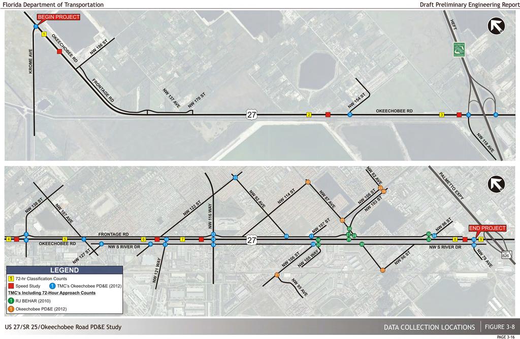
36
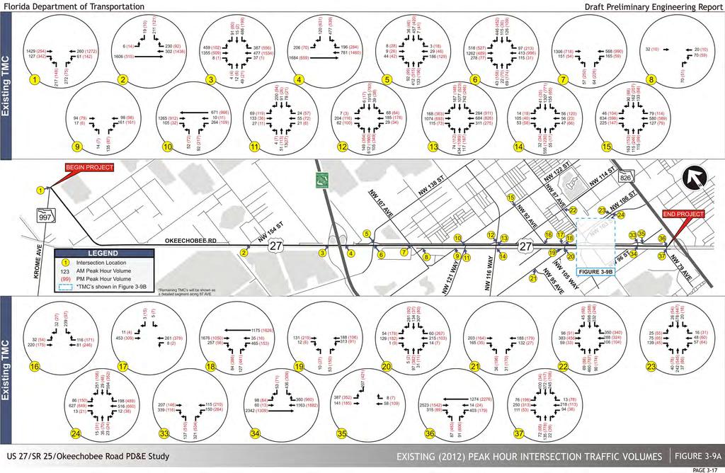
37
38 Figure 3-9B Existing (2012) Peak Hour Intersection Traffic Volumes Seventy-two (72)-Hour Bi-directional Machine Counts 72-Hour Bi-directional Machine Counts were collected on typical weekdays from Tuesday through Thursday. Counts were checked for reasonableness and adjusted for seasonal and axle factors. See Figure 3-8 for data collection locations: Additional 72-hour Bi-directional machine count data was obtained from the NW 87 th Avenue/SR 25 Okeechobee Road/NW 103 rd Street Traffic Study, supplied by District VI, FDOT. This study included the 72-hour count locations provided by this PD&E Study and the RJ Behar (2010) Design study shown on Figure 3-8. The hourly distribution of weekday traffic volumes along Okeechobee Road are presented in Figure Speed and Travel Time Data Speed and travel time data was collected from 5/22/12 to 5/24/12, on the segments shown on Figure (This space intentionally left blank) Existing Conditions & Evaluation Draft Preliminary Engineering Report 3-18

39
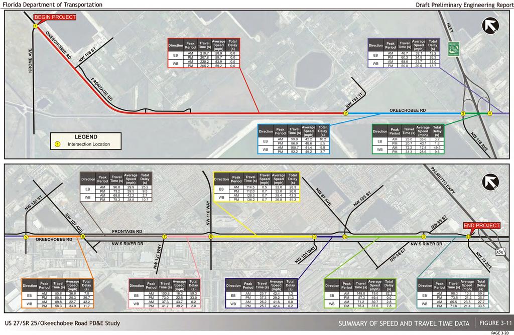
40
41 Design Traffic Factors Design Traffic Factors were obtained and/or developed to adjust field collected data and to calculate DDHV for each of the analysis years consistent with the following documents: Project Traffic Forecasting Handbook, Topic No , FDOT, January Florida Traffic Information DVD, Published by the FDOT (2011 FTI) FDOT Standard K guidance provided on FDOT website Peak Season Conversion Factors (PSCF) were obtained from the 2011 FTI and applied to peak hour volumes that were used in the operational analysis of existing conditions. Axle factors were applied to the collected counts as appropriate, and were obtained from the 2010/2011 FTI. Table 3-7 Traffic Factors Obtained from 2011 FTI DVD Site Description AADT (FTI) K Factor D Factor T Factor 0052 SR 997/Krome Avenue, 200 ft SW of SR 25/US 27/Okeechobee Road 12, Ramp from SB US 27 to SB Krome Avenue, 300 ft S of US 27 2, Ramp from NB Krome Avenue to SB US 27, 150 ft N of Krome Avenue 1, SR 25/US 27/Okeechobee Road, 1000 ft SE of Krome Avenue 15, SR 25/US 27/Okeechobee Road, 200 ft NW of SR 821/HEFT 22, SR 25/US 27/Okeechobee Road, 1000 ft from NB ramp to SR 821/HEFT 24, SR 25/US 27/Okeechobee Road, 0.7 miles N of SR 932, Miami-Dade County 31, SR 25/US 27/Okeechobee Road, 1000 ft NW of NW 103 rd Street 44, SR 25/US 27/Okeechobee Road, 1600 ft SE of NW 95 th Street 60, NW 138 th Street, 0.5 miles west of 36 th Avenue/97 th Avenue 15, NW 106 th Street, 300 ft NE of 106 th /102 nd Street (Hialeah Gardens Boulevard) 6, SR 932/NW 103 rd Street, 1400 E of W 28 th Avenue 18, Peak Hour Factor (PHF) was based on Table 10.1 of the Technical Resource Document 10 for the Interchange Handbook. The default PHFs for urban uninterrupted and interrupted flow facilities are 0.95 and 0.90, respectively. The AADT, K, D and T factors obtained from the 2011 FTI DVD are shown in Table 3-7 and the recommended factors, including standard K factors, are provided in Table 3-8. The recommended T factors were obtained by comparing the existing classification counts, turning movement counts and FTI Station data in order to properly represent the varying characteristics along the project corridor. The historical traffic information within the project vicinity has been summarized in Figure Table 3-8 Recommended Traffic Factors Road Segment Standard K Factor D Factor T Factor Okeechobee Road (from Krome Avenue to SR 821/HEFT) Okeechobee Road (from SR 821/HEFT to NW 103 rd Street) Okeechobee Road (from NW 103 rd Street to NW 79 th Avenue) SR 821/HEFT SB On/Off Ramps SR 821/HEFT NB On/Off Ramps SR 997/Krome Avenue SR 997/Krome Avenue Ramps to NB/SB Okeechobee Road SR 932/NW 103 rd Street Frontage Road 9.0 n/a 4 NW S River Drive 9.0 n/a NW 154 th Street NW 118 th Avenue 9.0 n/a 40 NW 138 th Street NW 107 th Avenue 9.0 n/a 26 NW 121 st Way 9.0 n/a 26 NW 116 th Way/Hialeah Gardens Boulevard NW 105 th Way 9.0 n/a 40 NW 87 th Avenue 9.0 n/a 6 NW 95 th Street 9.0 n/a 6 NW 79 th Avenue 9.0 n/a 10 Notes: The D factor for roads that don t have an FDOT count station were based on existing counts. T Peak=T 24 due to industrial characteristics, detailed map of recommended T Factors is provided in the Design Traffic Technical Memorandum. The default T factor for residential roads was assumed as 4%. The daily and peak hour truck factors for NW S River Drive and cross roads south of Miami Canal were based on classification counts. Existing Conditions & Evaluation Draft Preliminary Engineering Report 3-21
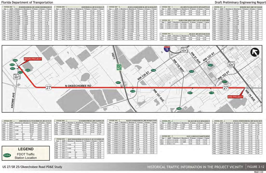
42
43 Safety Vehicular crash data was obtained for Okeechobee Road within the study area/area of influence covering the years The crash data was summarized to include type of collision, lighting conditions, and road surface, among others. Tables 3-9 and 3-10 reflect this information. Data regarding fatal crashes has been summarized in Table The crash data along with the pertinent analysis will assist in the identification of safety concerns and consequently in the development of potential improvements. Crash data and analysis information is provided in Appendix B. The analysis utilized the Crash Rates, Rate Quality Control and Safety Ratio formulas (which are used by the FDOT) to identify high crash locations. The following formulas are used to identify the crash rate on a particular roadway segment or intersection: Where (MVM used for segments and MEV for intersections): R C = critical crash rate per million-vehicle-miles (MVM) R a = average crash rate for locations with characteristics similar to the subject location. M = traffic volume at subject location in MVM or MEV K = constant corresponding to the level of confidence in the findings of the analysis. K Rural = (95 percentile level of confidence) K Suburban = 1.96 (97.5 percentile level of confidence) K Urban = (99.95 percentile level of confidence) R seg = crash rate for the roadway segment in million-vehicle-miles (MVM) A = number of reported crashes T = time period of the analysis in year(s) V = annual average daily traffic (AADT) L = Segment length in miles (This space intentionally left blank) R int = crash rate for the roadway intersection in million-entering-vehicles (MEV) A = number of reported crashes T = time period of the analysis in year(s) V = annual average daily traffic (AADT) The Rate Quality Control formula provides a statistical test to determine if the crash rate at the specific location is significantly higher than crash rates at locations with similar characteristics. This method employs the following equation: Existing Conditions & Evaluation Draft Preliminary Engineering Report 3-23
44 Table 3-9 Crash Summary Krome Avenue to the HEFT CRASH TYPE TOTAL PERCENT REAR-END % HEAD-ON % ANGLE % LEFT TURN % RIGHT-TURN % SIDE-SWIPE % BACKED INTO % COLL W PARKED CAR % COLL W MV ON RDWY % COLL W PEDESTRIAN % COLL W BICYCLE % COLL W ANIMAL % HIT SIGN/SIGN POST % UTILITY/LIGHT POLE % HIT GUARDRAIL % HIT FENCE % HIT BRIDGE PIER/RAIL % HIT CONC BARR WALL % HIT TREE/SHRUB % COLL W BARRICADE % HIT OTHER FIXED OBJ % COLL W MOVEABLE OBJ % RAN IN DITCH/CULVERT % RAN OFF ROAD % OVERTURNED % JACKKNIFED % CARGO LOSS OR SHIFT % SEPARATION OF UNITS % MEDIAN CROSSOVER % ALL OTHER/UNKNOWN % TOTAL % LIGHT CONDITIONS DAYLIGHT % DUSK % DAWN % DARK (STREET LIGHT) % DARK (NO STREET LIGHT) % UNKNOWN % TOTAL % SURFACE CONDITIONS DRY % WET % SLIPPERY % ALL OTHER % TOTAL % SEVERITY PDO % INJURY % FATAL % TOTAL % Table 3-10 Crash Summary- E of HEFT to NW 79 th Avenue CRASH TYPE TOTAL PERCENT REAR-END % HEAD-ON % ANGLE % LEFT TURN % RIGHT-TURN % SIDE-SWIPE % BACKED INTO % COLL W PARKED CAR % COLL W MV ON RDWY % COLL W PEDESTRIAN % COLL W BICYCLE % COLL W ANIMAL % HIT SIGN/SIGN POST % UTILITY/LIGHT POLE % HIT GUARDRAIL % HIT FENCE % HIT CONC BARR WALL % HIT TREE/SHRUB % HIT OTHER FIXED OBJ % COLL W MOVEABLE OBJ % RAN IN DITCH/CULVERT % RAN OFF ROAD % OVERTURNED % OCCUPANT FELL FROM VEH % JACKKNIFED % CARGO LOSS OR SHIFT % SEPARATION OF UNITS % MEDIAN CROSSOVER % ALL OTHER/UNKNOWN % TOTAL % LIGHT CONDITIONS DAYLIGHT % DUSK % DAWN % DARK (STREET LIGHT) % DARK (NO STREET LIGHT) % UNKNOWN % TOTAL % SURFACE CONDITIONS DRY % WET % SLIPPERY % ALL OTHER % TOTAL % SEVERITY PDO % INJURY % FATAL % TOTAL % Existing Conditions & Evaluation Draft Preliminary Engineering Report 3-24
45 Table 3-11 Fatal Crash Summary Krome Avenue to NW 79 th Avenue CRASH TYPE TOTAL PERCENT REAR-END % HEAD-ON % ANGLE % LEFT TURN % SIDE-SWIPE % COLL W PEDESTRIAN % UTILITY/LIGHT POLE % HIT GUARDRAIL % HIT OTHER FIXED OBJ % COLL W MOVEABLE OBJ % TOTAL % LIGHT CONDITIONS DAYLIGHT % DUSK % DARK (STREET LIGHT) % TOTAL % SURFACE CONDITIONS DRY % WET % TOTAL % It should be noted that there is an existing westbound "trap lane" that forces drivers to make a right-turn to the northbound HEFT. This condition is improperly signed and has resulted in a number of crashes including two fatalities. Additionally, five of the fatalities occurred at the curve just east of NW 186 th Street. The safety ratio formula, as indicated below, determines if the particular segment being analyzed can be considered a high-crash location where the actual crash rate is higher than the critical crash rate. Segment: Safety Ratio = SR = Rseg / RC Intersection: Safety Ratio = SR = Rint / RC Table 3-12 thru 3-14 provide a summary of the spot and segment safety ratio calculations. It should be noted that safety ratio calculations require a minimum of eight crashes for statistical significance. Therefore the following tables summarize only spots and segments that meet the minimum eight crash requirement. Detailed safety ratio worksheets are provided in Appendix B. Table 3-12 Okeechobee Road Spot Safety Ratio Summary Spot Year Average SR 997/KROM E AVENUE NW 154 th STREET NW 118 th AVENUE/ SB HEFT RAMPS NB HEFT RAMPS NW 138 th STREET NW 121 st AVENUE NW 116 th WAY NW 105 th WAY NW 103 rd STREET NW 95 th STREET NW 79 th AVENUE Number of Crashes Safety Ratio Confidence Level % % 99.75% 99.47% 99.94% 99.81% Number of Crashes Safety Ratio Confidence Level % % 99.24% % 99.80% Number of Crashes Safety Ratio Confidence Level % % % % 99.98% 99.26% Number of Crashes Safety Ratio Confidence Level 99.47% 96.36% 96.96% 95.60% 92.43% 94.37% Number of Crashes Safety Ratio Confidence Level 14.25% 99.98% % % 99.65% 82.78% Number of Crashes Safety Ratio Confidence Level 3.18% 36.27% 38.93% 6.93% 16.17% 20.30% Number of Crashes Safety Ratio Confidence Level % 99.98% % % Number of Crashes Safety Ratio Confidence Level 92.81% 18.87% 94.67% 15.95% 12.69% 44.93% Number of Crashes Safety Ratio Confidence Level 87.07% 99.99% % 19.57% 99.90% 81.31% Number of Crashes Safety Ratio Confidence Level 99.97% 48.45% 99.85% 97.54% 73.54% 88.87% Number of Crashes Safety Ratio Confidence Level % % % 99.90% % 99.98% Confidence level indicates high crash location for analysis year K Rural =1.645 used for intersections west of HEFT and K Suburban = 1.96 used for intersections east of HEFT Existing Conditions & Evaluation Draft Preliminary Engineering Report 3-25
46 Table 3-13 NW 103 rd Street Spot Safety Ratio Summary Spot Year Average NW 87 th AVENUE NW 82 nd AVENUE Number of Crashes Safety Ratio Confidence Level 93.78% 74.05% % % 99.97% 93.56% Number of Crashes Safety Ratio Confidence Level 16.98% 74.05% 99.92% 98.74% 99.98% 77.93% Confidence level indicates high crash location for analysis year Table 3-14 Okeechobee Road Segment Safety Ratio Summary Segment Year Average From NW 103 rd Street to NW 95 th Street From NW 95 th Street to NW 79 th Avenue Number of Crashes Safety Ratio Confidence Level 0.01% 0.00% 0.01% 0.01% 0.00% 0.00% Number of Crashes Safety Ratio Confidence Level 18.43% 14.35% 1.92% 3.70% 0.14% 7.71% Confidence level indicates high crash segment for analysis year (This space intentionally left blank) Based on the safety ratio analysis, ten intersections and one segment have been considered high crash locations during the five year crash history period. However, only the intersection of Okeechobee Road and SB HEFT Ramps/NW 118 th Avenue has been a high crash location for all five analysis years. It must be noted that according to the FDOT CARS database, only 3 crashes occurred along Frontage Road during the analysis years. This is likely due to unreported crashes. Existing Conditions & Evaluation Draft Preliminary Engineering Report 3-26
 is a rural area dominated by agricultural activities (Figure 3-13), and the eastern segment (from the HEFT to the eastern terminus) is dominated by")
47 3.1.9 Environmental Characteristics Land Use In general, the project study area has been divided into two segments, due to large differences in the surrounding land use. The western segment (from Krome Avenue to the HEFT) is a rural area dominated by agricultural activities (Figure 3-13), and the eastern segment (from the HEFT to the eastern terminus) is dominated by high density residential and industrial developments (Figure 3-14). community facilities include churches and other religious institutions, public and private schools, and public buildings and facilities such as fire stations, libraries, medical centers, and cemeteries. All of the community services discussed below are located in the eastern segment of the project except for Woodlawn Park Cemetery, which is located in the western segment. No significant direct, indirect, or cumulative impacts to community services are anticipated as a result of the project. Figure 3-15 shows the community resources near the project area. Figure 3-15 Community Services The western segment includes limited areas of unaltered native upland and wetland habitats, however areas or rangeland and altered wetlands are abundant along the project corridor. The project area includes a mix of agriculture with Improved Pasture (FLUCCS 2110) and Tree Nurseries (FLUCCS 2400) being the most prevalent. Urban and Built-Up lands (FLUCCS 1300s) occur sporadically within this western portion of the corridor. Upland Forests (FLUCCS 4000s) are present in low percentage and are predominantly Malaleuca (FLUCCS 6191) and Brazilian pepper (FLUCCS 4220). Other important resources found within the project corridor include surface water features (FLUCCS 5120 and 5300) as well as fresh water marshes (FLUCCS 6410) and forested wetlands (FLUCCS 6172, 6191, 6410 and 6430). Surface water features are primarily associated with containment and conveyance of roadway drainage in the area. East of the HEFT, land use is dominated by Urban and Built-Up lands (FLUCCS 1300s), with Commercial and Services (FLUCCS 1400), Industrial (FLUCCS 1500), Residential High Density (FLUCCS 1300), Other Light Industry (FLUCCS 1550), Institutional (FLUCCS 1700) and Open Land (FLUCCS 1900) occurring. Resources within the eastern portion of the corridor include substantial areas of surface water features (FLUCCS 5120 and 5300) with small areas of Upland Hardwood Forest (FLUCCS 4200). Surface waters include the Miami Canal, which is located adjacent to Okeechobee Road on the south side. Vegetated habitats within the project area have moderate to high levels of disturbance due to alterations, and are not considered pristine Cultural Features and Community Services Community service facilities provide a gathering place for adjacent neighborhoods and community members, as well as serving the needs of the surrounding areas. For the purpose of this study, Parks and Recreational Facilities Parks or other recreational facilities identified within close proximity to the proposed project corridor are all located north of Okeechobee Road, within the City of Hialeah Gardens municipality unless otherwise noted and include: Schools Bernie Wilson Park (NW 103 rd Street and NW 87 th Avenue, north side) Hialeah Gardens Linear Park (along NW 87 th Avenue Canal) Vietnam Veteran Memorial Park (NW 129 th Street and NW 104 th Avenue) Westland Gardens Park (13501 NW 107 th Avenue) Woodlawn Park Cemeteries (14001 NW 178 th Street, Hialeah) Three public schools and one charter school, which serve the area, are located within close proximity to the study corridor. These include: Hialeah Gardens Senior High School (11700 Hialeah-Hialeah Gardens Boulevard, Hialeah Gardens) Hialeah Gardens Middle School (11690 NW 92 nd Avenue, Hialeah) Existing Conditions & Evaluation Draft Preliminary Engineering Report 3-27

48
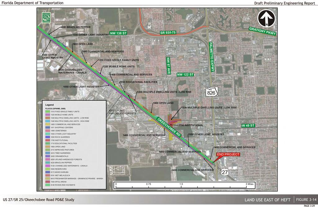
49
50 West Hialeah Gardens Elementary School (11990 NW 92 nd Avenue, Hialeah Gardens) Youth Co-Op Preparatory Charter School (7700 W 20 th Avenue, Hialeah) Two private schools are located in close proximity to the study corridor: or congressional offices, state, county, or city buildings and facilities located within the study area. The Brothers to the Rescue Memorial Park is a monument located at the intersection of 103 rd Street and NW 87 th Avenue. o Royal Kids Academy (12503 W Okeechobee Road, Hialeah) o Growing Treasures Learning Center 2 (8313 NW 103 rd Street, Hialeah) In addition, several other public and private schools were identified, but it was determined that there is no potential for impacts to those facilities due to their relative distances from the study corridor. Churches and Religious Institutions There are two churches/religious institutions found adjacent to, or within, close proximity to the project corridor. Iglesia Evangelica Agape (10601 NW 123 rd Street Road, Medley) Graham Baptist Church/Graham Mission (Okeechobee Road and NW 107 th Avenue) Fire and Police One fire station and one police station are located directly adjacent to the study corridor and within the project area: Hialeah Gardens Police Department (10301 NW 87 th Avenue, Hialeah Gardens) Miami-Dade Fire Department (8790 NW 103 rd Street, Hialeah Gardens) Medical and Emergency Operation Facilities There is no major medical and emergency operation facility located in close proximity to the study corridor. Other Public Buildings and Facilities The only public building located adjacent to the study corridor is the Hialeah Gardens City Hall (10001 NW 87 th Avenue, Hialeah Gardens). The proposed project is anticipated to improve access to the Hialeah Gardens City Hall. There are no other known federal buildings such as post offices Evacuation Routes and Emergency Services The State Emergency Response Team (SERT) identified the potential for natural disasters to occur within South Florida, principally the likelihood of a major hurricane making landfall in South Florida. Due to this natural disaster potential, SERT designated several of the major north-south roadway corridors throughout Miami-Dade County as crucial evacuation routes, including the SR 826, the SR 821 (HEFT) and SR 25 (Okeechobee Road) within the study area, due to their ability to expedite the movement of high traffic volumes Section 4(f) Resources A Section 4(f) Determination of Applicability (DOA), a companion document to this PD&E Study, was prepared for this project. The following properties were evaluated in the Section 4(f) DOA. Only Bernie Wilson Park and Elisabeth Brotons Park have been determined by FHWA to qualify as Section 4(f) resources. Hialeah Gardens Bernie Wilson Park This property is located within a triangularly shaped area delimited by the SFWMD C-7 Canal, NW 103 rd Street and the Hialeah Gardens Police Department on NW 87 th Avenue. FHWA determined that the portions of this park that are publicly owned qualify as a Section 4(f) resource for this project and information required by the FDOT PD&E Manual and FHWA Guidelines is provided in the project Section 4(f) Determination of Applicability (DOA). Hialeah Gardens Linear Park (Elisabeth Brotons Park) This property is located between NW 87 th Court and the NW 87 th Avenue Canal s west bank, and extends approximately 0.7 miles from NW 106 th Terrace to NW 117 th Street. This site qualifies as a Section 4(f) resource for this project and information required by the FDOT PD&E Manual and FHWA Guidelines is provided in the project Section 4(f) Determination of Applicability (DOA). Existing Conditions & Evaluation Draft Preliminary Engineering Report 3-30
51 Graham Dairy House The Graham Dairy House (8DA164) has been previously determined to be National Register eligible by the SHPO. This 1924 Mason Vernacular residence is located approximately a quarter mile north of 112 th Avenue on US 27 (Okeechobee Road). The Graham Dairy House is eligible for listing in the National Register under Criteria B and C. It is eligible under Criterion B for its association with Ernest R., Philip, William, and Bob Graham, significant figures in the history of South Florida and the country. It is eligible under Criterion C in the category of Architecture as a rare remaining example of native oolitic limestone architecture, which was designed in response to South Florida s climate and exemplifies an important phase in the architectural evolution of Miami- Dade County. Miami Canal The Miami Canal (8DA6525) has been previously determined to be National Register eligible by the SHPO. The Miami Canal originates at the southern shore of Lake Okeechobee and flows southeast to US 27 (Okeechobee Road) where it is parallels the highway until it empties into the Miami River in Miami. As one of the six primary canals of the Everglades Drainage District, the Miami Canal is a significant example of an early water management system. It is eligible for listing in the National Register under Criterion C in the category of Engineering. The canal is also eligible for listing in the National Register under Criterion A in the category of Community Planning and Development for its role in the development of South Florida. CERP North Lake Belt Storage Area, Central Lake Belt Storage Area, Lake Belt In-Ground Reservoir Technology Pilot, Broward County Water Preserve Areas These areas are designated for water management and conservation purposes in the Comprehensive Everglades Restoration Project (CERP) and are located adjacent to the western portion of the project corridor, west of the Florida Turnpike. No designated parking areas, signage or access is currently provided to the general public for their recreational use, thus FHWA determined that these areas would not protected under Section 4(f). No plans exist at the current time for the recreational use of these areas, the majority of which is still privately owned. Furthermore, no direct impact is expected to publicly owned parcels within these CERP areas. However, coordination with CERP officials will be maintained throughout the duration of the PD&E Study Aesthetics The project corridor consists of a major transportation facility that traverses through an undeveloped rural area and a significantly developed urban area, with almost no existing aesthetic characteristics. The only natural areas present along the corridor consist of stormwater management features associated with the roadway, which provide very little aesthetic value. No unique or historic architectural features are located along the corridor Archaeological and Historical Resources A Cultural Resources Assessment Survey (CRAS), a companion document to this PD&E study, was prepared within the project limits. A pedestrian survey confirmed the filled and developed nature of the project corridor, and did not identify any environmental factors indicative of archaeological site potential. A historic resources survey resulted in the identification of 13 historic resources within the Area of Potential Effect (APE). The identified historic resources (Table 3-15) include five canals and eight historic buildings. Six of these identified historic resources have been previously recorded (8DA164, 8DA6352, 8DA6525, 8DA11530, 8DA11531, 8DA11820) and seven are newly recorded (8DA DA14111). Two of the previously recorded historic resources have already been determined by the SHPO to be eligible for inclusion in the National Register: Graham Dairy House (8DA164) and Miami Canal (8DA6525). Both of the previously recorded National Register eligible resources were recently documented during the CRAS of the SR 924 (Gratigny Parkway) West Extension PD&E Study from SR 826 (Palmetto Expressway) to SR 821 (Homestead Extension of the Florida s Turnpike (HEFT)), conducted by Janus Research in Because no notable alterations that would impact the eligibility of either of these resources were observed during the current survey, FMSF forms were not updated for either the Graham Dairy House (8DA164) or the Miami Canal (8DA6525). Existing Conditions & Evaluation Draft Preliminary Engineering Report 3-31
52 Table 3-15 Identified Historic Resources within the Historic APE FMSF No. Name / Address Year Built Style National Register Status 8DA164 Graham Dairy House / Masonry NW 138 th 1924 Street Vernacular Determined Eligible 8DA6352 Little River Canal c Canal Ineligible 8DA6525 Miami Canal 1912 Canal Determined Eligible 8DA11530 Pennsuco Canal c Canal Ineligible 8DA11531 Golden Glades Canal Pre-1952 Canal Ineligible 8DA11820 NW 97 th Avenue Canal Pre-1963 Canal Ineligible 8DA W. Okeechobee Road c Masonry Vernacular Ineligible 8DA14106 Sims Crane Equipment / Masonry c NW S River Drive Vernacular Ineligible 8DA NW S River Drive c Masonry Vernacular Ineligible 8DA NW S River Drive c Masonry Vernacular Ineligible 8DA NW S River Drive c Masonry Vernacular Ineligible 8DA14110 Mega Design Corp. / NW Masonry c S River Drive Vernacular Ineligible 8DA14111 Juanita Matanzas / NW S Masonry c River Drive Vernacular Ineligible It was observed that the four remaining previously recorded historic resources (8DA6352, 8DA11530, 8DA11531, 8DA11820), all of which are canals, remain ineligible for listing in the National Register. Therefore, updated FMSF forms were not required for any of these resources. FMSF forms were prepared for the seven newly identified historic buildings (8DA DA14111). All seven of these buildings are considered ineligible for inclusion in the National Register either individually or as part of a historic district. The newly recorded buildings located within the APE have simple forms and common design types found throughout the state of Florida, and limited research revealed no significant associations with important persons or events. Furthermore, several have either alterations or condition issues that impact their historic integrity Natural and Biological Features Comprehensive Everglades Restoration Program (CERP) Conservation lands, including CERP projects, are present at multiple locations along the corridor (Figure 3-16). Conservation lands data was obtained from SFWMD GIS data layers. These lands are owned by the state, county, and private landowners. Some of the lands identified have already been acquired through easements and fee acquisition by the USACE and SFWMD; others are proposed for acquisition should funding become available and the CERP projects completed. Some lands have overlapping conservation designations and/or proposed uses Floodplains Based on the corresponding Federal Emergency Management Agency (FEMA) Flood Insurance Rate Maps (FIRM) (Appendix C), the mainline right-of-way of Okeechobee Road is not within the 100 year floodplain. A portion of the project is located in zone AE with a base flood level that varies from 6.00 feet to 7.00 feet NGVD. The remaining portion of the project is located in zone X. The FIRM for the area correspond to Community Panels No C0085L, 12086C0095L, 12086C0113L, 12086C0276L, and 12086C0277L within Miami-Dade County, Florida and Incorporated Areas (September 11, 2009) Groundwater Seasonal high groundwater levels are expected to be controlled by existing drainage features present at the project vicinity. The estimated seasonal high groundwater table levels are expected to range from elevation about +3.5 (NAVD 1988) at the west end of the project to elevation about +2 (NAVD 1988) at the east end of the project. This estimate was based on the groundwater monitoring data from US Geological Survey (USGS) Water Resources. The recorded groundwater level data of the USGS wells in the vicinity of the project can be found in the Preliminary Roadway Soil Survey Report prepared for this project (December 2013). (This space intentionally left blank) Existing Conditions & Evaluation Draft Preliminary Engineering Report 3-32
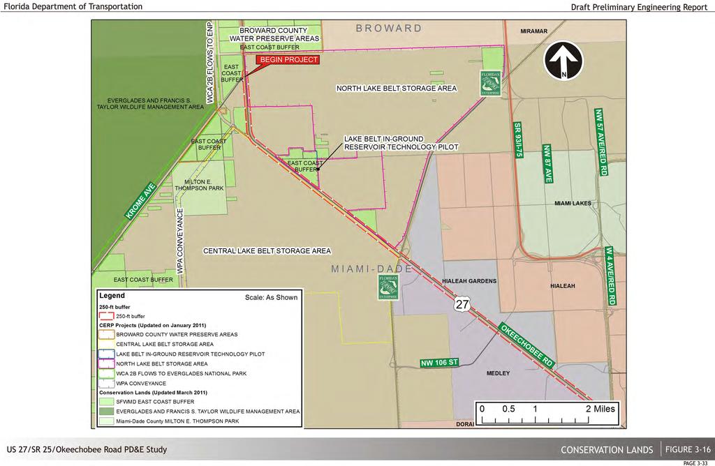
53
54 Wetland and Surface Waters The project area was reviewed to identify, map, and assess wetlands, surface water communities, and stormwater retention/detention/conveyance features that are located within or adjacent to the study corridor. A Wetland Evaluation Report (WER), a companion document to this PD&E study, was prepared for this project. substantial areas of surface water features (FLUCCS 5120 and 5300) with small areas of Upland Hardwood Forest (FLUCCS 4200). Surface waters include the Miami River, which is located adjacent to Okeechobee Road to the south. Vegetated habitats within the project area have moderate to high levels of disturbance due to alterations, and are not considered pristine. (Figure 3-18). Potential wetland areas were identified on a preliminary basis using recent aerial photographs of the corridor, National Wetlands Inventory (NWI) maps, SFWMD FLUCCS maps and the Miami- Dade County Soil Survey. Field investigations were conducted in which wetland vegetation, hydric soils and hydrology/the presence of hydrologic indicators was used to identify wetland areas. Visual surveys of properties adjacent to FDOT right of way were conducted for the East and West segments. The western section includes limited areas of unaltered native upland and wetland habitats, however areas of rangeland and altered wetlands are abundant along the project corridor. The South Florida Water Management District (SFWMD) FLUCCS GIS data layer was used to evaluate land use acreage and locations throughout the study area. The project area includes a mix of agriculture with Improved Pasture (FLUCCS 2110) and Tree Nurseries (FLUCCS 2400) being the most prevalent. Urban & Built-Up lands (FLUCCS 1300s) occur sporadically within this western portion of the corridor. Upland Forests (FLUCCS 4000s) are present in low percentage and are predominately Malaleuca (FLUCCS 6191) and Brazilian pepper (FLUCCS 4220). Other important resources found within the project corridor include surface waters and wetlands (FLUCCS 5000s and 6000s). These resources include a variety of surface water features (FLUCCS 5120 and 5300) as well as fresh water marshes (FLUCCS 6410) and forested wetlands (FLUCCS 6172, 6191, 6410 and 6430). Surface water features are primarily associated with containment and conveyance of roadway drainage in the area (Figure 3-17). East of the HEFT land use is dominated by Urban & Built-Up lands (FLUCCS 1300s), with Commercial and Services (FLUCCS 1400), Industrial (FLUCCS 1500), Residential High Density (FLUCCS 1300), Other Light Industry (FLUCCS 1550), Institutional (FLUCCS 1700) and Open Land (FLUCCS 1900) occurring. Resources within the eastern portion of the corridor include Wildlife and Habitat A preliminary data collection through literature reviews, ETDM review, agency database searches and coordination, and preliminary field reviews of potential habitat areas was performed to identify state and federally protected species occurring or potentially occurring within the project area. This project has been evaluated for the potential presence of threatened and endangered species in accordance with Section 7(c) of the Endangered Species Act (ESA) of 1973 as amended by Chapter 68 of the Wildlife Code of the State of Florida. In accordance with the FDOT PD&E Manual, Part 2, Chapter 27 Wildlife and Habitat Impacts (dated October 1, 1991), an Endangered Species Biological Assessment (ESBA), a companion document to this PD&E study, was prepared for this project and is available for review at the FDOT District Six offices in Miami. Through the review of USFWS, FNAI and FWC wildlife databases, scientists identified that a portion of the Miami Canal (along the southeastern segments of the corridor) is considered critical habitat for the West Indian manatee (Trichechus manatus). In addition, the project corridor lies within five wood stork (Mycteria americana) core foraging areas (CFA), and within the Florida bonotted bat and the snail kite (Rostrhamus sociabilis) Consultation Areas (Figure 3-19). Various landscapes exist throughout the project corridor that can potentially serve as habitat for listed species. The area is characterized by a man-altered landscape dominated by high and low impact urban lands (62%). Native plant communities comprise less than 15% of the area with freshwater marsh and wet prairies making up the remainder. Exotic plants and open water areas each total less than 10%. As previously stated, the project area consists of two main segments: east and west. The west segment of the project area consists mostly of non-developed sites, agricultural (including tree nurseries) land, pastures, and conservation areas. Wetland areas are present on the west Existing Conditions & Evaluation Draft Preliminary Engineering Report 3-34

55
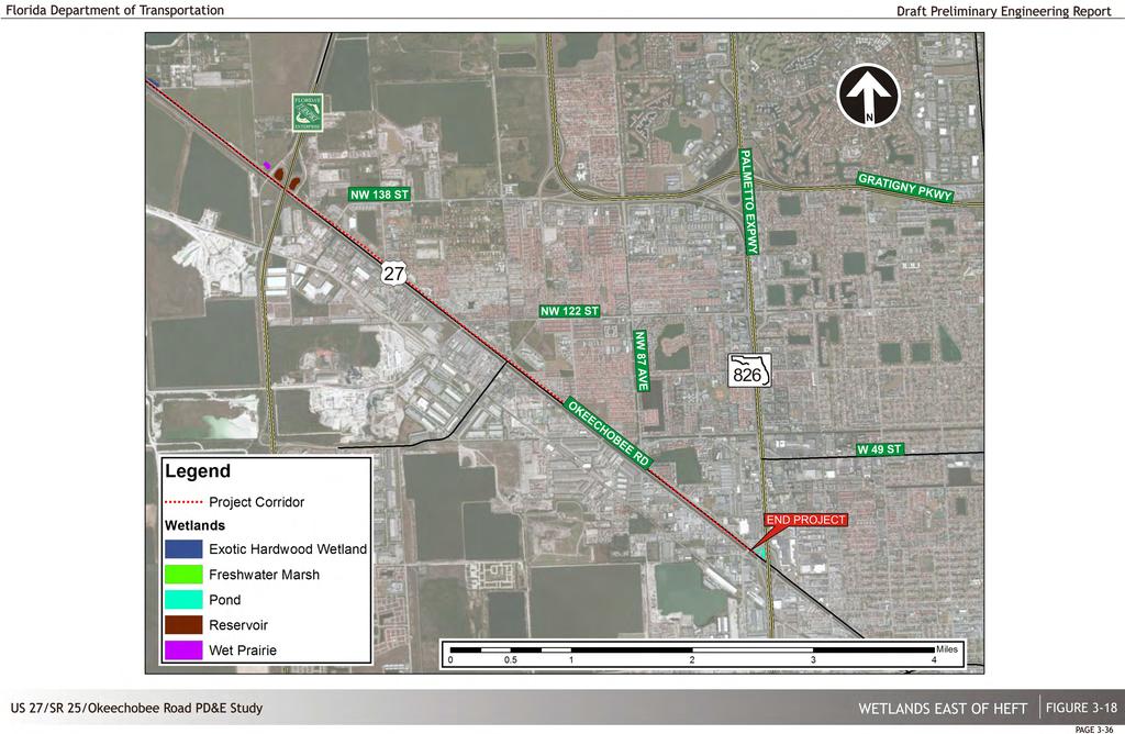
56
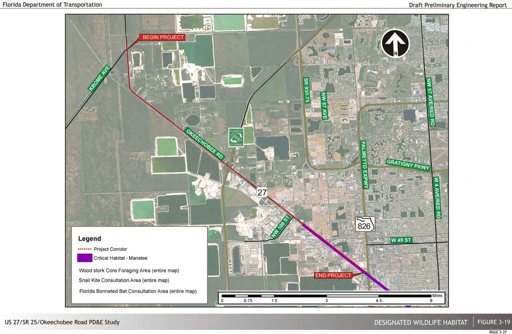
57
58 segment, although most of these wetlands consist of exotic hardwood wetland forests and construction activities for the west segment are not anticipated to impact these areas. Other environmental features within the west segment of the project consist of maintained swales that do not contain wetland vegetation. The east segment of the project consists of urban, commercially Other Coastal Zone Consistency In accordance with the FDOT PD&E Manual, Part 2, Chapter 25 Coastal Zone Consistency (dated April 12, 2011), this project was reviewed by the Florida Department of Environmental zoned plots. Maintained swales that do not contain aquatic vegetation are present between Protection (DEP) for consistency with the Florida Coastal Zone Management Plan. westbound/eastbound Okeechobee Road. Table 3-16 summarizes the federal and state listed species that could potentially occur within or in the vicinity of the proposed project. During the field review, scientists did not observe any wildlife species or indicators of wildlife species listed as threatened or endangered by the USFWS or the FWC. Table 3-16 Species listed as threatened or endangered by the USFWS or FWC Common Name Scientific Name Status USFWS FWC American Alligator Alligator mississippiensis T(S/A) FT Eastern Indigo Snake Drymarchon Couperi T FT Everglades Mink Neovison Vison N ST Florida Bonneted Bat Eumops Floridanus E ST Florida Burrowing Owl Athene Cunicularia N SSC Florida Manatee Trichechus Manatus E FE Least Tern Sternula Antillarum N SSC Limpkin Aramus Guarauna N SSC Little Blue Heron Egretta Caerulea N SSC Rim Rock Crowned Snake Tantilla Oolitica N ST Roseated Spoonbill Ajaja Ajaja N SSC Snail Kite Rostrhamus Sociabilis E FE Snowy Egret Egretta Thula N SSC Tri-colored Heron Egretta Tricolor N SSC White Ibis Eudocimus Albus N SSC Wood Stork Mycteria Americana E FE Notes: N = not listed, E = Endangered, T (S/A) = Threatened due to similarity of appearance, E = Endangered, FE = Federally Endangered, FT = Federally Threatened, ST = State-Threatened, SSC = State Species of Special Concern Physical Features Air Quality In accordance with the FDOT PD&E Manual, Part 2, Chapter 16 Air Quality Analysis (dated September 13, 2006), an Air Quality Technical Memorandum (AQTM) was prepared, which is available for review at the FDOT District Six offices in Miami, Florida. This project is included in the area s Transportation Improvement Program that has been approved by the Miami-Dade Metropolitan Planning Organization. The project is in an area designated as attainment. It is anticipated that by reducing congestion at the major intersections and interchanges along the project corridor, the proposed project will result in the long-term reduction of emissions to nearby air quality sensitive sites. This document does not incorporate an analysis of the green house gases (GHG) emissions or climate change effects of each of the alternatives because the potential change in GHG emissions is very small in the context of the affected environment. Because of the insignificance of the GHG impacts, those local impacts will not be meaningful to a decision on the environmentally preferable alternative or to a choice among alternatives. For these reasons, no alternatives-level GHG analysis has been performed for this project. Based on the air quality analysis conducted to date, air quality impacts are not expected to occur as a result of this project Noise Noise sensitive sites along the north side of Okeechobee Road primarily include multi-family apartment, townhome and condominium communities and the Country Manor mobile-home community. A community of zero-lot line, single-family homes is also found along the north side of Okeechobee Road. Other noise sensitive uses include schools, a medical facility and institutional uses. One hotel and a fitness trail are found along NW South River Drive, south of Okeechobee Road. Noise sensitive residential communities are also found along both sides of NW 87 th Avenue, the south side of NW 103 rd Street and the north side of W 52 nd Street. Noise sensitive sites Existing Conditions & Evaluation Draft Preliminary Engineering Report 3-38
59 identified along the project corridor having the greatest potential for traffic noise impacts include approximately 608 residences and the following non-residential noise sensitive special-use sites: Unnamed Linear Park block of NW South River Drive (fitness trail); Little Moments Preschool W Okeechobee Road (interior); Royal Kids Academy W Okeechobee Road (playground); Kingdom Hall of Jehovah s Witnesses W Okeechobee Road (interior); Hialeah Gardens Senior High School Hialeah Gardens Boulevard (breezeway); Hialeah Gardens City Hall W Okeechobee Road (interior); and, Signature Health Care 8333 W Okeechobee Road (interior). The project corridor also includes retail shopping centers, office buildings, commercial enterprises, industrial complexes and transportation uses that are not considered noise sensitive (i.e., Activity Category F). No building permits were found for any other potentially noise sensitive new construction along the project corridor. Existing noise levels were measured at four sites along the project corridor during 16 ten minute long sampling periods. Traffic noise levels were found to range from 57.8 to 73.6 db(a) at near meter locations and 53.4 to 67.2 db(a) at far meter locations. In all cases, traffic noise from either Okeechobee Road or NW 87 th Avenue was the predominant source of noise at the nearby noise sensitive sites Contamination A contamination screening evaluation was performed to evaluate the potential presence of contaminated sites within the project study corridor. Contamination of soil and/or groundwater by petroleum hydrocarbons and/or industrial chemical compounds has been documented at 40 locations within and adjacent to the study area, including the solid waste sites within a one-mile buffer. Table 3-17 is a summary of the contamination status of each of the High and Medium risk sites. Figure 3-20 and 3-21 show the location of all solid waste sites and contaminated sites, respectively, near and within the project corridor. Site No. Address Table 3-17 High and Medium Risk Sites Site Name DERM Permit No. FDEP Permit No. Risk Rating W Okeechobee Road South Florida Test Service IW N/A High 4 Okeechobee Road between Florida Turnpike & Krome Avenue Inter-FL Trucking Accident/Spill UT Medium 5 Okeechobee Rd, 2 miles NW of South Florida Water Management Florida Turnpike Truck Accident/Spill UT Medium 8 W Okeechobee Road & Florida Turnpike Johnson Trucking Accident/Spill N/A High 22 W Okeechobee Road & NW 121 st Way Perez Trucking Accident/Spill UT High W Okeechobee Road Twin Station UT High NW S River Drive Rock & Fill, Corp. UT High UT 1689 Bet Plant Services/Fencemasters NW S River Drive IW High Safety Green of Miami UT River Drive Fuel Express/American Intn l Express UT DO-Car Transport IW N/A Matadero El Corral IW 522 N/A Ruben & Emilio IW N/A NW S River Drive Chalet Restaurant Cafeteria, Inc. IW N/A M&F Truck Maintenance IW N/A High P&R IW N/A Pro Diesel & Turbo Services IW N/A Ramos Truck Service IW N/A Nica Truck Repair IW N/A Dump Trailer Center, Inc. IW N/A Armando s General Repair & Welding IW N/A Jose Alpuning Paving IW N/A Juan FCO. Diaz General Repairs IW N/A Toledo Truck Repairs IW N/A Gonzalez General Repair IW5 736 IW N/A Gondia Machine Shop IW N/A Navarro & Aleman Tire Center IW N/A Metal Precision, Corp. IW N/A Osvaldo Penton IW IW N/A Montiel Mechanic Shop, Corp. IW N/A NW S River Drive Basto Hydraulics General Repair IW IW N/A High Raul Heavy Electric, Corp. IW N/A Luis Silva General Repairs IW IW N/A Romero Super Truck IW5 250 UT Quality Road Service IW5 742 N/A Braojo s Electric IW N/A Alex Trucks & General Repair IW5 737 N/A FC Trucking IW N/A Hiram Fuentes General Welding IW5 740 N/A Omar General Welding IW5 741 N/A Roque General Welding, Inc. IW5 738 N/A Existing Conditions & Evaluation Draft Preliminary Engineering Report 3-39

60 Site No. Address Table 3-17 High and Medium Risk Sites (continued) Site Name DERM Permit No. FDEP Permit No. Risk Rating Figure 3-20 Potential Contamination Concerns Solid Waste Sites , 11002, NW S River Pepper Steel & Alloy/Miami Battery UT Drive Manufacturing Co. HWR-125 FLD High W Okeechobee Road Universal Concrete, Corp. UT 1366 N/A High W Okeechobee Road IW Best Truck Repair; Rose Cement; J&A IW Enterprises; Nilo Electric Repairs; Unlimited IW Diesel UT 3829 N/A High NW S River Drive Sims Crane & Equipment Lorenzo s Cafeteria UT High NW S River Drive Chem-Kleen Corp; Probex Fluids Recovery; Specialty Environmental Services; Coastal IW N/A High Fuels Marketting, Inc. 71 South River Drive East of NW 87 th Avenue Fl Spills N/A N/A High NW 95 th Street BJ s Wholesale Club (also SW Site 27) UT 6355 SW High IW NW 95 Street Evco Equipment Maintenance, Inc. IW N/A High A Art IW Transport Refrigeration IW Ravelo s Iron Works IW HQ Enterprises; Deaco Signs IW W Okeechobee Road International Body IW FLD High Florida Kitchen Cabinets; American, Corp. IW Star Tire IW Miami JDM Performance IW Manantial Auto Repair IW NW S River Drive Miami Safe & Lock UT Medium NW S River Drive Palmetto Auto Truck Stop UT High USA Truck Services Plaza IW W Okeechobee Road FLR Contreras Body Shop IW N/A Auto Diesel Service Plaza UT IW FLR SW-1 NW 112 th Avenue & NW 138 th Street Martinez Landfill SW-1026 N/A High SW NW 112 th Avenue Environmental Processing Systems SW-1119 N/A High SW-3 NW 107 th Avenue & NW 134 th Street Tony Waher Dump SW-1310 N/A High SW-4 NW 107 th Avenue & NW 145 th N/A Medium The De Moya Group, Inc. SW-1441 Street SW-5 NW 107 th Avenue & NW 145 th N/A Medium Community Asphalt SW-1445 Street SW-6 NW 107 th Avenue & NW 145 th N/A Medium Condotte America, Inc. SW-1440 Street SW NW 138 th Street Levenson Pomerantz Property SW-1177 N/A Medium SW-8 NW 99 th Avenue & NW 122 nd Street Biltmore Estate #2 SW-1039 N/A High SW NW 106 th Street Jim Wood Landclearing Co/Tallon Masters SW-1076 N/A High SW-10 NW 105 th Avenue & NW 106 th St Trashbusters Demolition and Recovery SW-1098 N/A High SW-11 Okeechobee Road between NW 89 th Avenue & NW 92 nd Avenue Lowell Dunn Company SW-1001 N/A High SW-16 NW 87 th Court & NW 114 th Street Biltmore Estates #4 SW-1056 N/A High SW-20 NW 87 th Court & NW 114 th Street Biltmore Estates SW-1027 N/A High SW-21 NW 107 th Avenue & NW 134 th St Medley Landfill SW-1003 N/A High SW NW 96 th Street G&A Properties SW-1278 N/A High SW-24 Okeechobee Road & NW 87 th Ave Samari Lake SW-1032 N/A High SW-25 NW 103 rd Street & NW 82 nd Ave Goodman-Greenberg Lakefill SW-1006 N/A High SW-30 NW 79 th Avenue & NW 95 th Street Peffers Dump/Walmart SW-1316 N/A High High High (This space intentionally left blank) Existing Conditions & Evaluation Draft Preliminary Engineering Report 3-40

61
62 Navigation There are no navigable waterways within the project study area. 3.2 Phase II Data Analysis Phase The second phase included the segmentation of the project and the analysis of the existing roadway and traffic/operational characteristics. Initially, it involved the establishment of all pertinent parameters which served as the criteria for evaluating the existing facility. These parameters (or features) represent integral components of the facility which might affect operations, capacity and safety. In total, ten (10) overall performance parameters dealing with the geometric and operational features of the existing project corridor were selected and evaluated according to current FDOT and AASHTO minimum design standards. Most of these parameters were evaluated based on the design speed. The design speed is defined as the maximum safe speed that can be maintained over a given section of highway when weather, light and traffic conditions are such that the design features of the highway govern. The basic purpose in using the design speed concept is to achieve consistency with the various design elements that influence vehicle operations. Figure 3-22 shows the existing conditions evaluation summary for the facility on a segment by segment basis illustrating the results of this task. Most of the evaluation parameters utilized a three (3) category scale for rating consisting of Good, Fair and Poor. A complete description of the evaluation criteria used in their analyses are included in Appendix D of this document Project Segmentation Prior to initiating the analysis of existing conditions, the project was broken down into two (2) distinct segments. As previously stated, the westernmost area of the project extending from the project beginning at SR 997/Krome Avenue to the SR 821/HEFT interchange is generally rural in nature, whereas the section from the SR 821/HEFT interchange to the eastern project limit at NW 79 th Avenue is much more urbanized. Each of these two segments has rather unique characteristics and patterns as well as potential differences in right-of-way, environmental, operational and access features. This methodology allows for site specific existing condition assessment Roadway Characteristics Cross Section This parameter relates to the adequacy and safety of such cross sectional elements as width of traffic lanes and shoulders clear zone and lateral clearances to roadside obstacles, guardrail treatment and location of embankment side slopes. As previously discussed, there are two distinct existing typical sections within the project corridor (see Figure 3-2) with 12-foot lane widths. Based on these characteristics major cross sectional elements along the facility were generally rated "Good" with the exception of some areas on the eastern segment mostly due to inadequate shoulder widths or clear zone Horizontal Alignment This geometric parameter is concerned with the degree of horizontal curvature, lengths of tangents and lane transitions as well as the coordination with the profile. In general terms, the project horizontal alignment is generally composed of a series of tangent sections with relatively small deflection angles or relatively flat curves. There is only one location with a significant horizontal curve located approximately one mile east of the project beginning at the Krome Avenue intersection; however, the westbound and eastbound lanes each have different curvature information. The curves correspond to an approximate design speed of 65 mph. Table 3-18 provides details of the curve information based on the most recent design plans. For stationing references please refer to Figure Since most of the existing horizontal components correspond to a very high design speed, this parameter was rated good along the facility. Since there are no other horizontal curves present along the rest of the project corridor, all other project segments were rated as Good. It should be noted that there are a number of curves along Frontage Road located at the approaches of all signalized intersections from NW 138 th Street to NW 79 th Avenue. Table 3-18 Horizontal Curves along Okeechobee Road Location Curve PC STA PI STA D Delta L (ft) R (ft) East of NW 186 th Street NW 117 th Avenue Eastbound 48'15'43.31" '02'32.44" Curve (RT) 1, , Westbound 48'17'17.03" '00'00" Curve (RT) 1, , '14'00'' 1'51'40.77" PRC '14'00'' 1'51'40.77" Existing Conditions & Evaluation Draft Preliminary Engineering Report 3-42
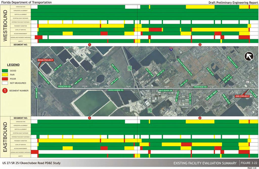
63
64 Vertical Alignment This geometric parameter deals with the vertical profile of the facility considering such elements as maximum grades, maximum change in grades, critical length of grade and coordination with horizontal alignment. No vertical curves are present within the project limits. In general terms, the existing facility exhibits a series of very long flat grades with no vertical curves. Therefore, this parameter was also rated Good along the facility Stopping Sight Distance Stopping sight distance is the length of roadway required for a driver to spot an object and negotiate a complete stop. This parameter is usually impaired by severe crests (or sags) in vertical alignment, poor horizontal alignment and/or roadside obstructions. Since these detrimental conditions are not present along the existing facility, this parameter was rated as Good Intersection Sight Distance This parameter relates to the provision of proper sight distances for a vehicle approaching an atgrade intersection. The sight distance considered safe under various assumptions of physical conditions and driver behavior is directly related to vehicle speeds and the resultant distances traversed during perception and reaction time and braking. Most project intersections received individual ratings of "Fair since visual observations confirmed that although not entirely clear from minor visual obstructions, the limit of clear sight was not appreciably hindered Traffic/Operational Characteristics Evaluation Level of Service Traffic operational analysis for existing conditions was performed using VISSIM and Synchro 8. Although Synchro 8 implements HCM 2010 procedures, the module has limitations in application of these procedures. Due to the characteristics at many of the study intersections (closely spaced intersections, lane assignments, signal phasing, etc.) Synchro 8 analysis results were used in lieu of the HCM 2010 in order to establish consistency in reporting results for comparison. VISSIM has the capability to model truck routes and truck composition, which is very useful due to the significant truck traffic generated by the industrial based land uses in the Town of Medley, just south of the project study area. VISSIM also has the capability to assign traffic patterns throughout the network and model short links, such as the close proximity that Frontage Road and NW South River Drive have to Okeechobee Road. Synchro 8 was used for existing and future intersection analysis of the signalized and unsignalized intersections within the study area. The analysis was performed for the AM and PM peak hours for the existing year (2012). Detailed information regarding the procedures used to establish the LOS of both the arterial and project intersections is documented in the Design Traffic Technical Memorandum prepared for this project. Figure 3-23 and Table 3-19 summarize the existing analysis results for the project intersections and segments, respectively Pavement Condition This parameter was based on the FDOT pavement condition survey for the past five years. The pavement condition survey only included information for the eastbound direction, thus the westbound was determined based on visual examination. The pavement condition report measures the degree of distress (structural adequacy) based on existing visible cracking and the riding quality of the pavement under consideration. In general terms, the pavement area was judged to be in "Fair" condition on the western segment and in "Good" condition on the eastern segment. It should be noted that a number of resurfacing projects have been completed recently including from NW 117 th Avenue to the Miami-Dade County line, at NW 121 st Way and at NW 138 th Street. (This space intentionally left blank) Existing Conditions & Evaluation Draft Preliminary Engineering Report 3-44

65
66 Direction Eastbound Westbound Table 3-19 Segment and Network Analysis Results 1 AM PM Road Segment Processed AVG Travel Processed AVG Travel Volume Speed Speed LOS Volume Speed Speed % LOS (vph) (mph) % of Sf0 (vph) (mph) of Sf0 Krome Ave to NW 154 St % A % A NW 154 St to HEFT West % B % A HEFT West to HEFT East % A % B HEFT East to NW 138 St % C % C NW 138 St to NW 107 Ave % B % B NW 107 Ave to NW 121 Way % B % C NW 121 Way to NW 116 Way % E % E NW 116 Way to NW 105 Way % C % B NW 105 Way to NW 103 St % C % B NW 103 St to NW 95 St % B % A NW 95 St to NW 79 Ave % D % D NW 79 Ave to NW 95 St % C % B NW 95 St to NW 103 St % C % C NW 103 St to NW 105 Way % B % C NW 105 Way to NW 116 Way % C % C NW 116 Way to NW 121 Way % A % B NW 121 Way to NW 107 Ave % A % B NW 107 Ave to NW 138 St % C % E NW 138 St to HEFT East % C % C HEFT East to HEFT West % C % C HEFT West to NW 154 St % A % A NW 154 St to Krome Ave % A % A 1 Simulated volumes and travel times are average values from 10 VISSIM runs 2 LOS using HCM thresholds and VISSIM speeds are provided for informational purposes only for lack of other approved methods to represent VISSIM LOS LOS below adopted LOS D Standard Access Management As previously stated, Okeechobee Road within the project limits is classified as a principal arterial facility with an Access Class 2. The evaluation of existing access was analyzed for compliance with FDOT s Access Management Classification System and Standards (Rule 14-97). There are three major components involved in access management analysis, and they generally relate to either median openings, driveway connections or traffic signals. component and their specific evaluation follows: A short description of each Median Opening Spacing As previously stated, the existing facility within the project limits is classified as an access class 2 facility. According to Chapter of the State Highway System Access Management Classification System and Standards, these facilities offer highly controlled access distinguished by the ability to serve high speed and high volume traffic over long distances in a safe and efficient manner. This access class is distinguished by a highly controlled limited number of connections median openings and infrequent traffic signals. The guidelines provided on Table 3-20 were used to evaluate the existing median openings on Table Location (Sta.) Table 3-20 Median Compliance Standards Full Median Opening Spacing Directional Median Opening Spacing Description Minimum Spacing Table 3-21 Existing Median Openings M.P. Distance to next Median Opening (ft) Required Standard Spacing (ft) Standard Met? Frontage Rd ' No NW 170 St ' Yes U turn ' Yes NW 127 Ave ' No NW 117 Ave ' No Driveway Connection Spacing There are no existing driveway connections directly tying to Okeechobee Road. As previously stated, a Frontage or service road generally serves the mobility and access needs of multiple abutting land uses just north of Okeechobee Road while on the south side NW S River Drive serves the mobility and access needs of land uses south of the project area. An access management evaluation has been provided on Figure Existing Conditions & Evaluation Draft Preliminary Engineering Report 3-46
67 Traffic Signal Spacing As previously stated, there are twelve (12) traffic signals within the confines of the project and the minimum signal spacing for an access class 2 facility is 2640 feet (0.50 mile). Table 3-22 illustrates the existing signal spacing and whether the standard spacings are met or not. Location Description M.P. Table 3-22 Existing Signal Spacing Distance to next signal (ft) Required Standard Spacing (ft) Standard Met? 1 Krome Avenue , Yes 2 NW 154 th Street , Yes 3 HEFT (SB Off-ramp) , No* 4 HEFT (NB On-ramp) , No* 5 NW 138 th Avenue , Yes 6 NW 107 th Avenue , Yes 7 NW 121 st Way , No 8 NW 116 th Way (Hialeah Gardens Boulevard) , Yes 9 NW 105 th Way , No 10 NW 103 rd Street , Yes 11 NW 95 th Avenue , No 12 NW 79 th Avenue * Contiguous Interchange Signals 3.3 Phase III - Conclusions and Recommendations The final phase of the existing conditions and evaluation study entailed reaching conclusions and recommendations for the proposed project improvements. The evaluation of the existing facility has identified certain geometric, operational, structural and safety deficiencies along the project limits as well as socio-economic/environmental concerns. Anticipated future conditions in the study area are expected to further degrade the existing deficiencies of the facility, thus requiring the implementation of major improvements. The primary objective of any proposed alternatives along the facility will involve the consideration of the following issues: Provide Safety improvements Provide operational improvements at key project intersections (including grade separated options) Provide pedestrian and bicycle enhancements Provide adequate capacity to meet future traffic demand Provide greater separation between signalized intersections where feasible along the cross streets Provide adequate intersection geometry to allow sufficient room for large trucks to perform turning maneuvers Provide aesthetically pleasing solutions that promote mobility and accessibility Minimize any social or environmental impacts Signing and Marking This parameter is concerned with the adequate and proper use of signing and markings along the facility. A visual inspection of the project corridor revealed that the existing signing and pavement markings are generally rated "Poor" at the intersections. It should be noted that there is an existing westbound "trap lane" that forces drivers to make a right-turn to the northbound HEFT. This condition is improperly signed and has resulted in a number of crashes including two fatalities Safety This parameter is based on the crash evaluation performed for the corridor that is summarized in section of this report. In general terms, the majority of the segments were rated "Good" and all of the intersections were either rated "Fair" or "Poor". Existing Conditions & Evaluation Draft Preliminary Engineering Report 3-47
68 4 DESIGN CONTROLS & STANDARDS Design controls and standards must be established prior to the formulation of design alternatives to ensure an adequate, safe, functional and operational roadway. These criteria are needed to develop typical sections, horizontal and vertical alignments, and other design features such as drainage, aesthetics, landscaping, and multimodal facilities. The controls and standards are those specified by the Florida Department of Transportation (FDOT) for state roadways. 4.1 Strategic Intermodal System (SIS) As previously mentioned, Okeechobee Road is functionally classified as a divided, rural principal arterial west of the HEFT and as a divided urban principal arterial east of the HEFT. Okeechobee Road is designated part of Florida's Strategic Intermodal System (SIS). The SIS comprises the state's largest and most strategic transportation facilities, including major air, space, water, rail, and highway facilities. The SIS facilities are the primary means for moving people and freight between Florida's diverse regions, as well as between Florida and other states and nations. The SIS is Florida's highest statewide priority for transportation capacity improvements. The FDOT has adopted standards for SIS facilities related to level of service (LOS), access connectivity, typical section/laneage and speed. The standards for SIS that apply to the Okeechobee Road facility as well as the other roadways in the study area are enumerated in Table 4-1 and are discussed below. *minimum design speed Table 4-1 Strategic Intermodal System Criteria ITEM Level of Service Design Speed Connectivity CRITERIA Urban D Rural - B Rural 65 mph* Urban 50 mph* All urban areas need connection with a limited-access facility 4.2 Geometric Design Criteria Geometric criteria pertaining to the proposed improvements are documented in several FDOT manuals, Federal Highway Administration publications, and in publications of the American Association of State Highway and Transportation Officials (AASHTO). The design criteria used in this project are based on these publications. Table 4-2 shows the roadway design criteria for Okeechobee Road, Frontage Road, NW S River Drive and ramps. Table 4-3 shows the bridge design criteria. General Criteria Section Features Horizontal Alignment Clear Zone Design Criteria Table 4-2 Roadway Design Criteria From SR 997/Krome Avenue to HEFT Okeechobee Rd From HEFT to NW 79 Ave Frontage Rd NW S River Drive Ramps Urban Principal Rural Principal Arterial Roadway Classifications Arterial Service Road Collector N/A SIS SIS 40 mph 55 mph 50 mph Existing Posted Speed mph at 30 mph mph intersections Design Speed 65 mph 60 mph 45 mph mph Design Vehicle WB-62 FL WB-62 FL WB-62 FL WB-62 FL WB-62 FL Access Class 2 (With service roads) 2 (With service roads) - - Statewide Minimum LOS B D D D Lane widths, through 12 ft 12 ft 12 ft 12 ft 15 ft Lane widths, turning 12 ft 12 ft 12 ft 12 ft N/A Median Widths 40 ft 40 ft N/A N/A N/A Inside Shoulder 8 ft 12 ft N/A N/A N/A Outside Shoulder 12 ft 12 ft 12 ft 8 ft 8 ft Max. Defl. w/o curves 0º45'00" 0º45'00" 2º00'00" N/A 0º45'00" Min. Length of Curves Min. Curv., radius w/super Min. Curv., radius w/o super 975 ft desirable (400 ft. min) 900 ft desirable (400 ft. min) 675 ft desirable (400 ft. min) N/A 50 mph: 750 ft (desirable) 30 mph: 450 ft (desirable) 400 ft minimum 1348 ft N/A N/A N/A N/A 13,164 ft 11,709 ft 6,878 ft 35 mph: 4,384 ft ; 30 mph: 3,349 ft 35 mph: 250 ft 30 mph: 200 ft 50 mph: 8,337 ft; 30 mph: 3,349 ft Stopping Sight Distance 645 ft 570 ft 360 ft 50 mph: 425 ft 30 mph: 200 ft Clearance 36 ft 36 ft 18 ft 10 ft 50 mph: 14 ft 30 mph: 10 ft Pavement Cross Slope Border Width 40 ft 40 ft 33 ft N/A 50 mph: 40 ft 30 mph: 33 ft Design Controls & Standards Draft Preliminary Engineering Report 4-1
69 Vertical Alignment Table 4-2 Roadway Design Criteria (Cont'd) Design Criteria Okeechobee Rd NW S River From SR 997/Krome From HEFT to NW Frontage Rd Drive Avenue to HEFT 79 Ave Ramps Signals Vertical Cl ft 17.5 ft 17.5 ft 17.5 ft 17.5 ft Maximum Grade 5% 5% 7% 4% (Industrial 50 mph: 5% classification) 30 mph: 7% Minimum Grade 0% 0% 0% 0% 0% Base Clear above DHW EL 3 ft 3 ft 2 ft N/A 2 ft Max change in grade 35 mph: mph: w/o curve 30 mph: mph: 1.00 Minimum SSD 645 ft 570 ft 305 ft 35 mph: 250 ft 50 mph: 425 ft 30 mph: 200 ft 30 mph: 200 ft Minimum Length of 35 mph: 105 ft 50 mph: 300 ft 450 ft 400 ft 120 ft Crest Curves 30 mph: 90 ft 30 mph: 90 ft Minimum K Value Crest 35 mph: mph: Curves 30 mph: mph: 31 Minimum Length of Sag 35 mph: 105 ft 50 mph: 200 ft 350 ft 300 ft 120 ft Curves 30 mph: 90 ft 30 mph: 90 ft Minimum K Value Sag 35 mph: mph: Curves 30 mph: mph: 37 Loads Impact Thermal Forces Seismic Wind Loads Vertical Clearance Table 4-3 Bridge Design Criteria Unit weight of reinforced concrete Unit weight of steel Unit weight of aluminum Future wearing surface Traffic railing barrier Compacted soil Stay in place forms Live Load: HS 20/ HL93 30% per FDOT structures design guidelines Mean ambient temperature Temperature rise (Concrete) Temperature fall (Concrete) Temperature rise (Concrete Deck on Steel Girder) Temperature fall (Concrete Deck on Steel Girder) Thermal coefficient (Concrete) Thermal coefficient (Concrete Deck on Steel Girder) Seismic design as per Structures Design Guidelines As per FDOT structures design guidelines, section feet over 4.95 ft. Design Water Surface (NAVD88) 6 feet over 0.95 ft. Optimum Water Surface (NAVD88) 16.5 feet over roadway 150 lb/c.ft. 490 lb/c.ft. 173 lb/c.ft. 15 lb/s.ft. 420 lb/ft. 115 lb/c.ft. 20 lb/s.ft. 70 Degrees Fahrenheit 35 Degrees Fahrenheit 35 Degrees Fahrenheit 40 Degrees Fahrenheit 40 Degrees Fahrenheit per degree Fahrenheit per degree Fahrenheit 4.3 Drainage Criteria The FDOT Drainage Manual gives standards for the design of state roadway drainage. These standards include general criteria, hydrologic methods, and construction and maintenance considerations. Also, the South Florida Water Management District (SFWMD) sets criteria for stormwater management. It should be noted however, that in many cases, the local criteria are more stringent than that of the state and regional agencies Water Quality Criteria Florida Department of Environmental Protection (FDEP) The FDEP new Statewide Stormwater Treatment Rule is not the Statewide Environmental Resource Permit (SWERP). Instead, it is a rule that is being developed to control nutrient loadings from stormwater discharges that may further pollute the waters of the state. The new Statewide Stormwater Treatment Rule had not been scheduled for implementation at the time of the preparation of this report. At a minimum, water quality criteria shall be based on SFWMD and DRER SFWMD The project limits are within the SFWMD jurisdiction. This project will be designed to meet current water quality standards as outlined by Chapter , Florida Administrative Code. Retention/Detention Criteria (Section of Basis of Review for ERP Applications): Wet detention- provide volume for the first inch of runoff from the developed project area, or the total runoff of 2.5 inches times the percentage of impervious area, whichever is greater. Dry detention volume shall be provided equal to 75% of the wet detention volume. Retention volume will provide 50% of the wet detention volume. Retention volume included in flood protection calculations requires a guarantee of long term operation and maintenance of system bleed-down ability Department of Regulatory and Economic Resources (DRER) DRER adopts SFWMD criteria for water quality. Therefore, areas impacted within DRER s jurisdiction, such as County owned canals, shall be in accordance with the SFWMD criteria. Design Controls & Standards Draft Preliminary Engineering Report 4-2
70 4.3.2 Water Quantity Criteria SFWMD - Discharge Rate Off-site discharge rate for the project area is limited to rates not causing adverse impacts to existing off-site properties, and: historic discharge rates rates determined in previous SFWMD permit action, or basin allowable discharge rates specified by District criteria The 25 year 72 hour design storm shall be used to determine the off-site discharge rates. It should be noted that there are no existing discharge rate requirements for the C-6 Canal (Miami Canal) or C-7; however SFWMD requires a pre (existing) versus post (proposed) development analysis for discharge to the canal DRER - Discharge Rate DRER does not have an allowable discharge requirement for their canals which are connected to SFWMD s canal since SFWMD has existing control structures to regulate their canals FDOT- Hydraulic Conveyance Stormsewer shall be checked against the 10yr-1hr, 10yr-8hr, 10yr-24hr, 100yr-1hr, 100yr-8hr, and 100yr-24hr storm events. Table 3 provides the approximate rainfall amounts obtained from the Zone 10 IDF curve. Table 4-4 Florida Precipitation Rainfall Amount (Zone 10) Storm Event Rainfall Amount 10yr-1hr 3.6" 10yr-8hr 6.5" 10yr-24hr 8.9" 100yr-1hr 5.1" 100yr-8hr 9.6" 100yr-24hr 13.2" 10yr-1hr 3.6" Stormwater Management Facilities FDOT The design of stormwater management systems for Department projects shall comply with the water quality, rate, and quantity requirements of Section (15), F.S., Chapter 14-86, F.A.C., Rules of the Department of Transportation. Standard design features for detention and retention ponds are as follows: 1. Maintenance Berm: Ponds shall be designed to provide a minimum 20 feet of horizontal clearance between the top edge of the normal pool elevation and the right-of-way line. At least 15 feet adjacent to the pond shall be at a slope of 1:8 or flatter. The berm area shall be sodded. 2. Side Slopes: Ponds shall be designed to provide 1:4 side slopes. 3. Corners: Corners of ponds shall be rounded to provide an acceptable turning radius for maintenance equipment. 4. Freeboard: As a safety factor for hydrologic inaccuracies, control structure clogging, and downstream stage uncertainties, at least 1 foot of freeboard is required above the maximum design stage of the pond. The freeboard is the vertical distance between the maximum design stage elevation of the pond and the front face of the berm. 5. Fencing: Ponds having side slopes steeper than 1:4 shall be provided a protective barrier (e.g., wall, fence, etc.) to prevent unauthorized entry. Gates for maintenance access shall be placed at appropriate locations. 6. Access Easements: When pond areas are not accessible directly from the road right-of-way, an access easement shall be provided. 7. The maximum dry pond recovery time shall not exceed more than 24 hours. 8. Dry ponds shall have a minimum elevation of 1 foot above the wet season high groundwater table Reference Manuals Design criteria from the following references where used for this project. 1. FDOT Drainage Manual (2014) 2. FDOT Drainage Handbook Hydrology (2012) 3. FDOT Drainage Handbook Storm Drains (2012) Design Controls & Standards Draft Preliminary Engineering Report 4-3
71 4. Florida Department of Environmental Protection (FDEP) Applicnt s Handbook Volume I (2015) 5. Florida Department of Environmental Protection Environmental Resource Permit Applicant s Handbook Volume I and South Florida Water Management District s Applicant s Handbook Volume II of the Environmental Resource Permit Information Manual (2014)South Florida Water Management District Environmental Resource Permit Information Manual (2014) 6. South Florida Water Management District s Applicant Handbook Volume II (2014) 7. Miami-Dade County Code of Ordinances Chapter 24: a. Article IV Natural and Biological Environmental Resources Permitting and Protection; Regulation of Drainage Systems and Stormwater Management b. Article V Stormwater Utility Design Controls & Standards Draft Preliminary Engineering Report 4-4
72 5 ALTERNATIVES CONSIDERED Previous sections of this report documented the project area existing deficiencies, needs and future conditions. Based on these factors and also public/agency input, a c omprehensive alternative development and evaluation process was initiated and conducted for the proposed project improvements. The different phases involved in the selection of the recommended alternative for the proposed project are generally outlined and summarized in this section. As illustrated on Figure 5-1, a multi-phase alternative development, evaluation and selection process was employed to properly assess all alternatives considered for the proposed improvements of Okeechobee Road within the project limits. Essentially, four (4) different phases comprised the alternative selection process for the proposed project (in addition to the evaluation of existing conditions) as illustrated in the figure. Those alternative options found most feasible, which merited further development and evaluation, are shown in yellow in the various evaluation tables. A discussion of each of the four (4) different phases follows: facility by means of improving high accident spots and segments, adding auxiliary lanes, providing additional lanes by reducing lane widths and shoulder widths, converting lanes to HOV use, providing an intelligent management system, improving intersections and signalization, improving signing, pavement markings and delineation, etc. Table 5-1 provides an evaluation of the various potential TSM&O strategies considered along the facility. The TSM&O options highlighted in yellow are the strategies recommended for further evaluation. As shown on the table, a number of TSM&O options will alleviate many of the existing deficiencies along the project corridor. However, these TSM&O improvements will only alleviate the many operational, geometric and safety deficiencies along some portions the existing Okeechobee Road facility. Their implementation alone would not suffice to meet current and future travel demand throughout the corridor. It was, therefore concluded during the initial stages of the project that in addition to the TSM&O solutions, major reconstruction alternatives would be required to allow the improvement of the existing facility at various locations throughout the project corridor (i.e. NW 116 th Way, NW 107 th Avenue, NW 105 th Way, NW 103 rd Street/NW 87 th Avenue). It is because of these facts that TSM&O alternatives will be further considered as valuable components of an integrated final solution. 5.1 Phase One: Conceptual Design Analysis This phase involves the generation and preliminary evaluation of the No-Build alternative, Transportation System Management and Operational Alternatives and the major alternatives. A brief description of each follows: No-Build Alternative The No-Build or No Project Alternative would result in the retainage of the existing Okeechobee Road facility with its present operational and safety deficiencies. Future conditions are expected to result in even more severe deficiencies. Although the No Project Alternative does not solve any of the project deficiencies, it does provide an accurate yardstick or baseline condition by which other project alternatives can be compared throughout the project alternative selection process Transportation Systems Management and Operational (TSM&O) Alternatives The Transportation Systems Management and Operational (TSM&O) Alternatives are comprised of minor improvement options and are usually generated to achieve the maximum use and energy efficiency of the existing facility. The investigation explored the alternative of upgrading the existing TSM&O ALTERNATIVES Additional mainline lane provision thru reduction in lane and shoulder widths Converting mainline lanes for exclusive HOV use Physical and operational improvements to high accident spots or segments Provide additional turn lanes and signal optimization at intersections ITS features (i.e. traffic surveillance and control systems, DMS signs) Current return radius at bridges over the Miami Canal Improved signing, markings and delineation Table 5-1 Evaluation of TSM&O Alternatives CONSEQUENCES OF IMPLEMENTATION Would actually worsen existing deficiencies due to substandard section and ability to carry higher volumes through a highly turbulent area Minor gain in capacity at the expense of safety Will not meet future capacity issues Will not alleviate any of the major existing deficiencies due to the fact that more than 90% of the vehicles on Okeechobee Road originate or are destined to this area (i.e. are turning at the number of intersection and not traveling through the area) Will not meet future traffic demands Addition of acceleration lanes along Okeechobee Road to allow space for heavy trucks to accelerate to normal operating speeds outside of the travel lanes Correction of inadequate turning radius at intersections to allow enough space for large trucks to make turning movements Will significantly improve operations at NW 154 th Street, NW 138 th Street and NW 95 th Street; however, will not address future demand at NW 116 th Way and NW 103 rd Street/NW 87 th Avenue and alleviate existing deficiencies Will significantly improve operations at NW 107 th Avenue, NW 121 st Way, NW 105 th Way and NW 79 th Avenue but requires widening of existing bridges over the Miami Canal Provision of WB turbo lanes at NW 107 th Avenue will reduce vehicle conflicts and improve operations Some minor improvements to operations in area, however major existing deficiencies would remain Will not provide sufficient capacity increases to meet future travel demand Will improve truck traffic operations accessing the numerous industrial sites in Town of Medley Requires widening of existing bridges Only slight improvements in guidance and possibly safety. Will not alleviate any of the major existing deficiencies; however will improve unsafe conditions REMAINS VIABLE? NO NO YES YES YES YES YES Alternatives Considered Draft Preliminary Engineering Report 5-1
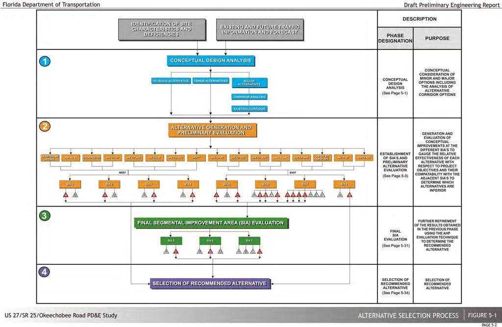
73
74 5.1.3 Major Alternatives An important initial component of the major alternatives is the consideration of alternative corridor options for the proposed project. A brief description of this task follows: Alternative Corridor Analysis As previously stated, the project area is generally rural in nature from the begin project to the HEFT Interchange, but heavily urbanized east of the HEFT. Within the rural project segment Okeechobee Road is bordered by CERP projects, farmland, and nu rseries along the north side and the Miami Canal on the south side. Within the urbanized eastern project segment there are two distinct areas bordering the existing corridor. A long the north side is the City of Hialeah Gardens with a mix of businesses (mostly retail including Wal-Mart and Home Depot) and a densely populated area of multifamily and mobile homes. Along the south side, the Town of Medley is predominantly dense industrial with numerous large industrial plants. Figure 5-2 illustrates some key landmarks along the existing corridor. Some of the key differences between the retention of the existing corridor and the provision of a new one are as follows: 1. In general terms the existing corridor would basically maintain the same land use patterns adjacent to the facility while other options have the potential to alter land uses and to be less compatible with the areas they would traverse. 2. The potential number and types of residential and business displacements, impacts to cultural and community services and c ommunity cohesion problems associated with alternate corridors would result in major impacts to the surrounding communities and neighborhoods. 3. The development of a new corridor will also create impacts to historical and archaeological sites. Several parklands are also located around the project area. 4. The existing corridor will impact the least number of known hazardous material contamination sites compared to a new corridor, which would have more significant impacts. 5. The various costs associated with this type of project would generally be l ess by improving the existing facility than by providing a new corridor alignment. T he greater the amount of new construction and right-of-way required, the greater the overall costs. In conclusion, an investigation of the area surrounding the existing facility has determined that the existing corridor location offers the best potential for the fulfillment of the project's needs. The consideration for developing any major highway at a new location is severely limited by physical, environmental, and economic constraints. The use of a majority of the existing facility s right-of-way makes the proposed improvements on the existing corridor the most reasonable choice. The next step involves the generation of various alternatives within the existing corridor which strive to mitigate or remove the exiting and projected deficiencies at all project intersections as well as those deficiencies mainly associated with lack of segmented capacity between project intersections. The following sections describe the generation and evaluation associated with these alternatives. (This space intentionally left blank) Alternatives Considered Draft Preliminary Engineering Report 5-3

75 Figure 5-2 Corridor Considerations 5.2 Phase Two: Alternative Generation and Preliminary Evaluation Segmental Improvement Areas (SIA) The initial step in generating adequate solutions to address the project needs within the existing corridor involves identifying geometric, operational, access and safety issues affecting all project intersections. It is clear however that quite often, due to the close proximity of other contiguous intersections, some potential intersection improvements could likely impact an adjoining intersection and thus cannot be considered as isolated entities. Because of this fact, the project was divided in eight (8) distinct segmental improvement areas (SIA), four covering the rural western portion extending from the begin project to the HEFT interchange and four covering the project s urban eastern from the HEFT interchange to end of project. Figure 5-3 illustrates the eight SIA s and Table 5-2 provides a generalized description of the SIA breakdown. (This space intentionally left blank) Alternatives Considered Draft Preliminary Engineering Report 5-4
76
77 WEST EAST SIA NO Table 5-2 Segmental Improvement Area (SIA) Breakdown LIMITS From begin project to just east of NW 186 th St. From just east of NW 178 th St. to just east of NW 170 th St. From just west of NW 129 th St. to just east of NW 154 th St. HEFT/ Okeechobee Rd. Interchange From just west of NW 138 th St. to just east of NW 107 th Ave. From just west of NW 122 nd St. to just east of NW 92 nd Ave. From just west of NW 106 th St. to just east of NW 87 th Ave. From just west of NW 95 th St. to just east of NW 79 th Ave. MAIN INTERSECTIONS WITHIN SIA Krome Ave. / Okeechobee Rd. NW 186 th St./ Okeechobee Rd. NW 170 th St. / Okeechobee Rd. NW 170 th St. / Frontage Rd. NW 127 th St. / Frontage Rd. / Okeechobee Rd. NW 154 th St. / Okeechobee Rd. West HEFT / Okeechobee Rd. East HEFT / Okeechobee Rd. NW 138 th St. / Okeechobee Rd. NW 107 th Ave. / Okeechobee Rd. NW 116 th Way / Frontage Rd. / Okeechobee Rd. NW 116 th Way / NW S River Dr. NW 92 nd Ave. / Okeechobee Rd. NW 105 th Way / Okeechobee Rd. / S River Dr. NW 103 rd St. / Frontage Rd. / Okeechobee Rd. NW 87 th Ave. / Frontage Rd. / Okeechobee Rd./NW S River Dr. NW 95 th St. / Frontage Rd. / Okeechobee Rd. NW 79 th Ave/Okeechobee Rd/NW S River Dr GENERAL CHARACTERISTICS Rural segment with most problems concentrated at the two main intersections Rural segment with most problems associated with the most efficient access provision to the land uses along the north side of Okeechobee Rd. Rural segment with two intersections in relatively close proximity which limits the effective use of auxiliary lanes Major partial cloverleaf interchange with indirect movements to/from the south Urban segment with insufficient capacity at the NW 138 th St. / Okeechobee Rd. intersection Urban segment with insufficient capacity at closely spaced intersections Urban segment with insufficient capacity at closely spaced intersections Heavily congested urban segment REMARKS - Traffic operational differences between competing alternatives insignificant. - This interchange has been studied as part of the HEFT PD&E Study and their recommended configuration will be adopted - - Most complex project area requires consideration of high cost synergistic solutions to solve/mitigate complex operational and access problems Requires additional coordination to account with potential improvement of the SR 826 interchange by others Figures 5-4 through 5-11 illustrate the various alternatives that were generated to mitigate/eliminate the various deficiencies associated with each segmental improvement area. It should be noted that many of these alternatives include the TSM&O components previously discussed on page 5-1. Following is a brief description of the preliminary alternatives that were generated for each of the projects eight (8) SIA s: 1) SIA 1 From begin project to just east of NW 186 th Street (see Figure 5-4) Most of the problems associated with this area are concentrated on the two main Okeechobee Road intersections. Alternative 1A realigns the Krome Avenue intersection to only provide one traffic signal in the eastbound direction as opposed to the existing two signals, and also features an additional northbound to westbound and westbound to southbound left turn lanes thus addressing a capacity deficiency. Alternative 1B is similar to Alternative 1A in that it only provides one traffic signal as opposed to the existing two signals, and provides two westbound turbo lanes at the Krome Avenue intersection to facilitate free flow conditions for the westbound Okeechobee Road traffic. The westbound turbo lanes however, would preclude the northbound Krome Avenue and eastbound Okeechobee Road traffic from accessing the Miami-Dade Aviation Department (MDAD) property whose access is just north of Krome Avenue. 2) SIA 2 From just east of NW 178 th Street to just east of NW 170 th Street (see Figure 5-5) The most critical issue within this SIA relates to the determination of the most effective provision of auxiliary lanes (acceleration/deceleration) between the two relatively close Okeechobee Road intersections. Alternative 2A closes the existing median opening at the Frontage Road connection providing a r ight-out only and thus facilitates local access to the Frontage Road via NW 170 th Street. Alternative 2B on the other hand, closes the existing median opening at NW 170 th Street and provides local access via the existing Frontage Road/Okeechobee Road connection. These improvements allow the provision of adequate acceleration and deceleration lanes in all directions. 3) SIA 3 From just west of NW 129 th Street to just east of NW 154 th Street (see Figure 5-6) Similarly to the previous SIA, the relatively close proximity of two Okeechobee Road intersections (NW 127 th Avenue and NW 154 th Street) limits the provision of adequate auxiliary lanes. Alternative 3A provides adequate westbound acceleration lane west of NW 127 th Avenue while Alternative 3B closes the existing median opening at NW 127 th Avenue and provides a new one at NW 129 th Avenue. This modification provides additional spacing along Okeechobee Road Alternatives Considered Draft Preliminary Engineering Report 5-6
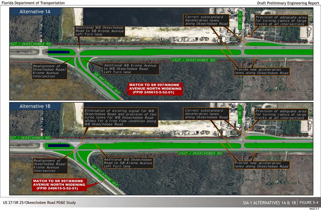
78
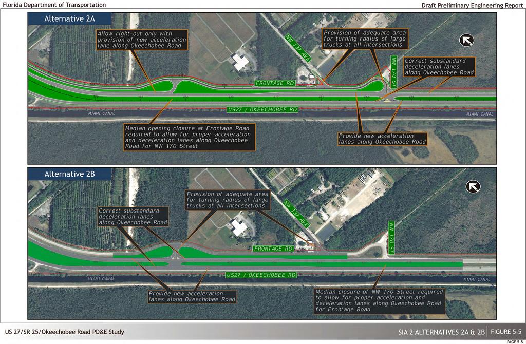
79

80
81 between NW 154 th Street and the new NW 129 th Avenue and thus facilitates the provision of adequate acceleration and deceleration lanes. 4) SIA 4 HEFT/Okeechobee Road Interchange (see Figure 5-7) Improvements to the HEFT/Okeechobee Road interchange were recently investigated as part of the HEFT PD&E Study. Figure 5-7 shows the recommended option extracted from that study. The main features of the recommended option include the addition of two new ramps across the Miami Canal which would provide a di rect connection for the eastbound Okeechobee Road to southbound HEFT and the northbound HEFT to eastbound Okeechobee Road movements thus reducing delays at the two existing HEFT/Okeechobee Road signalized intersections. Additionally, the on-going SR 924/Gratigny Expressway West Extension PD&E is proposing to provide an extension of SR 924 along NW 138 th Street with a direct connection to/from southbound HEFT. Alternative 4A assumes no additional improvements are provided. Alternative 4B provides an additional left turn lane (to provide a total of two left turn lanes) from eastbound Okeechobee Road to northbound HEFT in addition to the improvements from Alternative 4A. 138 th Street and the northbound HEFT ramp. Additionally, a signal is provided at the intersection of NW 138 th Street and Frontage as well as additional turn lanes and more ample intersection turning radii. This alternative increases the capacity of NW 107 th Avenue and reduces delays along Okeechobee Road by providing three westbound turbo lanes as well as an additional northbound left turn lane along NW 107 th Avenue which will require widening of the bridge over the Miami Canal. Alternative 5B is similar to the previous option but also grade-separates westbound Okeechobee Road over NW 138 th Street. This overpass is expected to slightly improve the operation of the at-grade NW 138 th Street intersection; however, the bridge precludes vehicles from NW 138 th Street and NW 107 th Avenue from accessing northbound HEFT due to the short weaving distance. Alternative 5C provides the sufficient space necessary for the eastbound/westbound lanes to turn concurrently without truck restrictions by widening the existing bridge over the Miami Canal. Under this condition only a s ingle southbound right turn lane is provided eliminating the weaving condition in Alternative 5A thus allowing two southbound left turn lanes. In addition, two westbound right turn lanes have been provided for increased capacity and to eliminate queue spilling over onto the mainline. 5) SIA 5 From just west of NW 138 th Street to just east of NW 107 th Avenue (see Figures 5-8a and 5-8b) The critical issues within SIA 5 are due to the insufficient capacity at the intersections of NW 138 th Street and NW 107 th Avenue coupled with heavy truck percentages. Additional significant deficiencies are the closely spaced intersections along NW 138 th Street and the lack of adequate storage for the turning movements. It is important to note that NW 138 th Street provides a direct connection to the Gratigny Expressway (West Extension) resulting in even higher future traffic volumes. NW 107 th Avenue also experiences heavy truck traffic with insufficient laneage requirements to access Okeechobee Road from the Pennsuco Industrial Park. 6) SIA 6 From just west of NW 122 nd Street to just east of NW 92 nd Avenue (see Figure 5-9a and 5-9c) The principal deficiencies within this segment include the following: 1) insufficient capacity at major signalized intersections, 2) close proximity of signalized intersections along NW 116 th Way/Hialeah Gardens Boulevard due to closely spaced parallel facilities (i.e. NW S River Drive, Okeechobee Road and Frontage Road), 3) competing maneuvers between trucks and c ars at the limited number of access points creates driver confusion, 4) due to the close proximity of the intersections, truck queues block many of the intersections at NW S River Drive and the Frontage Road. Alternative 5A widens Okeechobee Road to add n ecessary dual-left turn lanes destined northbound and southbound along NW 138 th Street, however in order to avoid impacts to the newly constructed NW 138 th Street bridge over the Miami Canal, the eastbound/westbound dual left turn lanes would require lane restriction for trucks, which is a safety concern. It also provides two free flow southbound right turn lanes which create a deficient weaving condition between NW Alternative 6A is composed of an at-grade solution which restricts the east-west local traffic across NW 116 th Way at NW S River Drive and at the Frontage Road. This option provides a new atgrade connection with Okeechobee Road at NW 92 nd Avenue to facilitate local access for the area north of Okeechobee Road and east of NW 116 th Way. In addition, a new exit connection from Okeechobee Road to the Frontage Road would be provided just west of NW 116 th Way to further Alternatives Considered Draft Preliminary Engineering Report 5-10

82
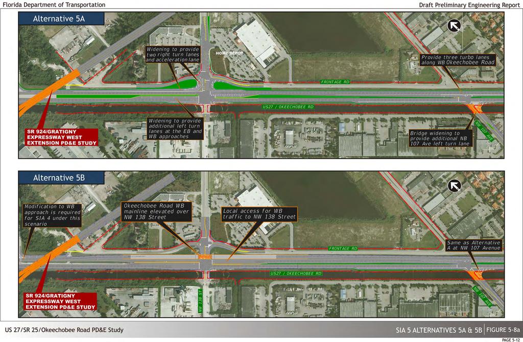
83

84
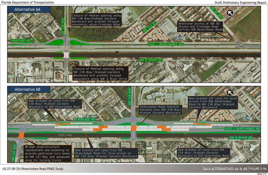
85
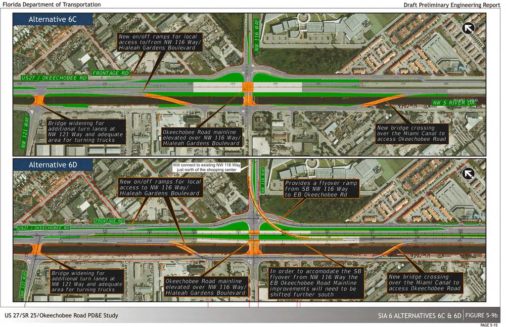
86
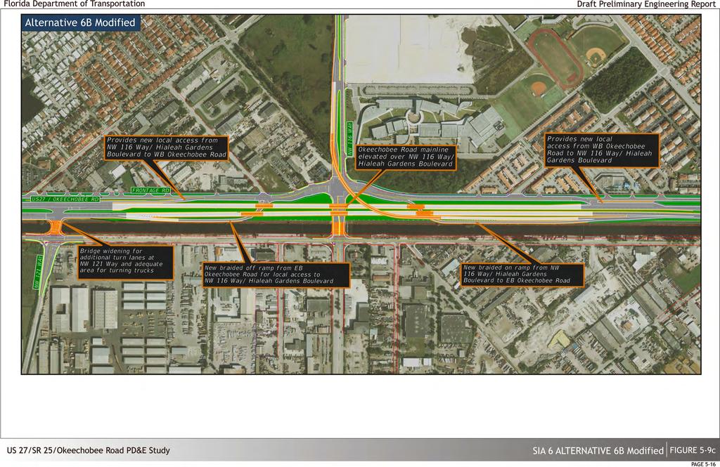
87
88 compensate for the loss of east-west access across NW 116 th Way. Alternative 6B features a system of braided ramps providing access to/from the Frontage Road. Although this alternative provides significant improvements in terms of traffic, it restricts access to a number of land uses located north of Frontage Road. Alternative 6B Modified is generally similar to the previous alternative, however it provides new intersections along Frontage Road instead of a s ystem of braided ramps. Alternative 6C also features a grade separated option with the Okeechobee Road mainline elevated over NW 116 th Way and generally providing a diamond type configuration with the Frontage Road and NW S River Drive. Improvements require two new bridges over the Miami Canal. Alternative 6D is similar to the previous option but also provides an elevated flyover ramp connection from southbound NW 116 th Way to eastbound Okeechobee Road. This ramp is expected to significantly improve the operation of both at-grade NW 116 th Way intersections. Due to costly business and residential relocations, reconstruction of NW S River Drive, further refinements in traffic operations and continued stakeholder coordination, the previously top ranked alternatives (Alternatives 6B and 6D) were further refined and combined to develop 6B Modified. 7) SIA 7 From just west of NW 106 th Street to just east of NW 87 th Avenue (see Figures 5-10a, 5-10b, 5-10c and 5-10d) This segment is also characterized by its congested conditions along both the Okeechobee Road mainline as well as the various closely spaced intersections. The provision of the new NW 87 th Avenue connection across the Miami Canal will generate significant access and operational maneuvers between the closely spaced parallel facilities (NW S River Drive, Okeechobee Road, Frontage Road and NW 103 rd Street). It should be noted that the "no build" conditions assumed in this SIA include the improvements currently under design (FM# ) that are programmed to be constructed by the Department in Alternative 7A features operational and capacity improvements at the NW 103 rd Street intersection while grade separating the Okeechobee Road mainline traffic over NW 105 th Way as well as the planned improvements at the NW 103 rd Street and NW 87 th Avenue intersections. Alternative 7B is very similar to the previous option, however, it does not provide a grade separation over NW 105 th Way and instead closes the existing bridge/access to Okeechobee Road and realigns NW 106 th Street creating a new access point to Okeechobee Road from NW S River Drive. Due to the fact that most vehicles accessing Okeechobee Road at this location are coming from NW 106 th Street (NW 106 th Street has indirect access to the HEFT via NW 116 th Way), this realignment serves to improve the operational deficiencies associated with vehicles maneuvering from NW 106 th Street to Okeechobee via NW 105 th Way as well as addressing the existing functional structural deficiencies of the current twin bridges. This option also creates the necessary distance to facilitate the grade separation over NW 103 rd Street and NW 87 th Avenue. It should be noted that Alternative 7A and 7B provide no i mprovements along NW 87 th Avenue and N W 103 rd Street. Alternative 7C depresses the Okeechobee Road mainline under NW 87 th Avenue and provides a service road for the local movements to NW 87 th Avenue. This option realigns NW 103 rd Street further to the north to create more separation between the signalized intersections and provide the required storage for turning movements. The west leg of the realigned NW 103 rd Street/NW 87 th Avenue intersection will only allow through/left turn movements and will not provide any receiving lanes thus closing the access from NW 103 rd Street to Okeechobee Road. Lastly, it provides two flyover ramps from northbound/southbound NW 87 th Avenue to westbound/eastbound Okeechobee Road. Both of these ramps will address the heavy left turn volumes accessing Okeechobee Road from NW 87 th Avenue. After the completion of the DTTM prepared for this project, Alternative 7C Modified was developed to avoid impacts to the existing 15 foot corrugated metal pipe (CMP) cross drain. Alternative 7C Modified is similar to Alternative 7C but instead elevates the Okeechobee Road mainline to a third level over NW 87 th Avenue and the directional flyovers. It should be noted that operationally both alternatives are almost identical. Additionally, this alternative provides a free flow right turn for southbound NW 87 th Avenue vehicles destined to westbound Okeechobee Road via a new road west of NW 87 th Avenue. This provides substantial traffic improvements at the NW 87 th Avenue/ NW 103 rd Street and the NW 87 th Avenue / Okeechobee Road intersections. Alternative 7D depresses Okeechobee Road and realigns NW 103 rd Street. However, this option also provides a flyover ramp from NW 103 rd Street to westbound Okeechobee Road and southbound NW 106 th Street further improving the network traffic flow. Alternative 7E is similar to the previous options in that it also realigns NW 103 rd Street further north. This option maintains the Okeechobee Road mainline at existing ground elevation while providing an elevated diverging diamond along NW 87 th Avenue. Alternative 7F is similar to the previous options in that it also realigns NW 103 rd Street further north. This option also elevates the Okeechobee Road mainline over an at-grade roundabout at NW 87 th Avenue. Alternatives Considered Draft Preliminary Engineering Report 5-17
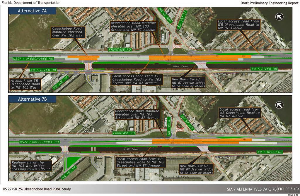
89
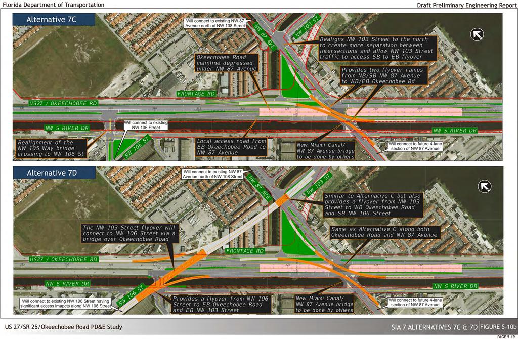
90
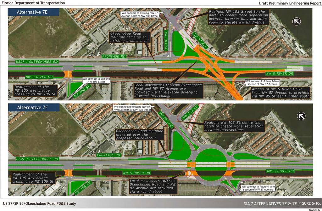
91

92
93 8) SIA 8 From just west of NW 95 th Street to just east of NW 79 th Avenue (see Figure 5-11) This SIA is heavily congested requiring widening of the mainline facility to improve its operational efficiency. In addition, insufficient turning radii and l ane storage capabilities severely limit the available capacity of several signalized intersections. Alternative 8A features the provision of additional capacity along both the mainline and at all the SIA intersections which includes but is not limited to the addition of turning lanes and the extension of existing storage lanes, as well as more ample intersection turning radii to facilitate operations. Additionally, a westbound turbo lane is provided along the Frontage Road for vehicles turning right from NW 95 th Street destined to westbound Frontage Road. This requires the relocation of the entrance to BJ's Warehouse further east. Alternative 8B is generally similar to the previous option but also provides a new westbound connection to Okeechobee Road from Frontage Road in order to facilitate egress maneuvers from major traffic generators land locked by SR 826 and Okeechobee Road. These provisions can be seen more clearly in Figure Preliminary Alternative Evaluation Tables 5-3 through 5-10 are numerical/descriptive matrices, which illustrate, describe and evaluate the features of all generated major alternatives at each SIA. The evaluation method used involved the generation of a weighting scheme for each of the evaluation parameters. The evaluation parameters generally fall within four general criteria categories, engineering, socioeconomic, environmental, and cost. Ten (10) to fifteen (15) different evaluation sub-criteria were used. Each sub-criteria was assigned a value depending on its perceived degree of importance. These criteria and sub-criteria weightings were developed from the average of individual weighting sets prepared by members of the consultant s team reflecting a broad range of professional backgrounds. I n addition, the alternative performance with respect to each parameter was compared using two benchmarks; 1) the overall effect on the specified parameter and/or 2) the relative effect between the competing alternatives. The overall effect received one of the five judgmental values (++ = 1.00, + = 0.80, o = 0.60, - = 0.40, - - = 0.20). If, however any of the alternatives had an overall negative effect, then the worst alternative received a (- -) and the relatively better alternative received a higher score (-). If any two values were approximately equal then they both received the relatively lowest score. If the alternatives had an overall positive effect then the best alternative received a (++) and the relatively worse alternative received a lower score (+). A common value, therefore, signifies an equal overall and relative effect. This evaluation involves a c ombination of both qualitative and quantitative values resulting in an overall score. Each score indicated on the matrices is the result of multiplying the judgmental analysis rating times the relative weight for that parameter. For example, on Table 5-3, alternative 1B under the "controversy potential" parameter was given a (-) designation (judgmental value = 0.4) since there is a p otential for controversy. This judgmental value of 0.4 was then multiplied by the relative weight of the "controversy potential" parameter (9.0) resulting in an overall score of 3.6. Those alternative options found most feasible, which merited further development and evaluation, are shown in yellow. (This page intentionally left blank) Alternatives Considered Draft Preliminary Engineering Report 5-22

94
95 Table 5-3 SIA 1 Preliminary Alternative Evaluation LEGEND ++ SUBSTANTIALLY POSITIVE EFFECT OR BEST ALTERNATIVE GENERALLY POSITIVE EFFECT OR GOOD ALTERNATIVE 0.8 O GENERALLY NO EFFECT OR MODERATE ALTERNATIVE GENERALLY NEGATIVE EFFECT OR INFERIOR ALTERNATIVE GENERALLY NEGATIVE EFFECT OR WORST ALTERNATIVE 0.2 SIA 1 PRELIMINARY ALTERNATIVE EVALUATION ALTERNATIVES CRITERIA ENGINEERING ENVIRONMENTAL SOCIO-ECONOMIC COST TRAFFIC SERVICE SAFETY ACCESS CONSIDERATIONS WETLAND IMPACTS CONSERVATION AREAS WILDLIFE AND HABITAT HURRICANE EVACUATION / EMERGENCY SERVICE CONTROVERSY POTENTIAL RIGHT-OF-WAY CONSTRUCTION o o o o + o o - RANK 1A - Realignment of ramps and elimination of one EB signal - Dual WB Okeechobee Rd to SB Krome Ave left turn lanes - Dual NB Krome Ave to WB Okeechobee Rd left turn lanes -Adequate turning radii for trucks Realignment of the intersection, provision of additional WB Okeechobee Rd to SB Krome Ave left turn lane and additional NB Krome Ave to WB Okeechobee Rd left turn lane significantly decreases intersection delay. Provision of adequate acceleration and deceleration lanes in the immediate vicinity of the NW 186 St intersection promotes operational efficiency Elimination of one of the EB Okeechobee Rd signals should decrease the high number of rear end crashes. Provision of adequate auxiliary lanes along Okeechobee Rd at NW 186 St should decrease angle and sideswipe crashes Preserves all required access connections Generally similar to Alternative 1A Generally similar to Alternative 1A No impacts to wildlife or habitat will occur Generally similar to Alternative 1A No perceived significant controversy potential Will not require any R/W acquisition Generally similar to Alternative 1A 1 (66.0) o o o B - Okeechobee WB Turbo Lanes with additional WB to SB left turn lanes - Realignment of ramps and elimination of one EB signal -Adequate turning radii for trucks Provision of WB turbo lanes, realignment of the intersection and additional WB to SB turn lanes significantly increases capacity at the intersection. Provision of adequate acceleration and deceleration lanes in the immediate vicinity of the NW 186 St intersection promotes operational efficiency Provision of WB Okeechobee Rd turbo lanes will reduce the high number of rear end for the through movement. Provision of adequate auxiliary lanes along Okeechobee Rd at NW 186 St should decrease angle and sideswipe crashes Provision of turbo lanes preclude the access from the WB Krome Ave traffic to the Miami- Dade Co Aviation Dept (MDAD) parcel (just west and north of the Krome Ave intersection) No impacts to existing wetlands. The areas that will be impacted due to construction consist of swales with no wetland vegetation present No impacts to conservation areas. The SFWMD East Coast Buffer, the Broward County Water Preserve Area, and the North Lake Belt Storage Area are located near the project corridor, however construction activities will not encroach into CERP limits No impacts to wildlife or habitat will occur Additional operational improvements will facilitate hurricane evacuation and emergency services High controversy potential due to opposition from the MDAD. Partially restricts access to their parcel entrance along the north side of Okeechobee Rd Will require construction of a new access for the MDAD property and thus will require R/W acquisition Construction costs are relatively minor. Reconstruction of the Krome Avenue intersection could increase MOT costs 2 (57.2) Alternatives Considered Draft Preliminary Engineering Report 5-24
96 Table 5-4 SIA 2 Preliminary Alternative Evaluation LEGEND ++ SUBSTANTIALLY POSITIVE EFFECT OR BEST ALTERNATIVE GENERALLY POSITIVE EFFECT OR GOOD ALTERNATIVE 0.8 O GENERALLY NO EFFECT OR MODERATE ALTERNATIVE GENERALLY NEGATIVE EFFECT OR INFERIOR ALTERNATIVE GENERALLY NEGATIVE EFFECT OR WORST ALTERNATIVE 0.2 SIA 2 PRELIMINARY ALTERNATIVE EVALUATION ALTERNATIVES CRITERIA ENGINEERING ENVIRONMENTAL SOCIO-ECONOMIC TRAFFIC SERVICE SAFETY ACCESS CONSIDERATIONS WETLAND IMPACTS CONSERVATION AREAS WILDLIFE AND HABITAT HURRICANE EVACUATION / EMERGENCY SERVICES CONTROVERSY POTENTIAL RIGHT-OF-WAY COST CONSTRUCTION RANK 2A - Allow only right out from Frontage Rd and improve turning radius at NW 170 St - Add acceleration and deceleration lanes Provision of adequate acceleration and deceleration lanes in the immediate vicinity of NW 170 St promotes operational efficiency. Provision of standard turning radii along Frontage Rd for large trucks reduces delays and improves operational conditions o o o o + o - o Provision of Okeechobee Rd acceleration lane at the Frontage Rd and NW 170 St intersections should decrease the probability of angle and sideswipe crashes. Provision of adequate The Central Lake Belt Okeechobee Rd Storage Area, the deceleration lanes at SFWMD East Coast the NW 170 St No impacts to existing Buffer and Lake Belt In- Relatively minor Provides more Requires minor R/W intersection should also wetlands. The areas Ground Reservoir Additional operational construction costs. convenient EB ingress acquisition at the increase safety. that will be impacted Technology Pilot are improvements will No perceived Additional pavement access from No impacts to wildlife or western corner of the Elimination of median due to construction located near project facilitate hurricane significant controversy required for acceleration Okeechobee Rd to habitat will occur NW 137 Avenue and opening at the consist of swales with corridor. evacuation and potential and deceleration lanes most land uses along Frontage Road Okeechobee no wetland vegetation Improvements will not emergency services and turning radius the north side intersection Rd/Frontage Rd present encroach on the CERP improvements intersection decreases areas. Improvements the number of potential are not proposed in conflict points. conservation areas Relocation of access provision to/from existing land uses north of Okeechobee Rd away from existing Okeechobee Rd horizontal curve is a safer condition o o o + o - o 1 (68.8) 2B - Close NW 170 St and improve turning radius at Frontage Rd - Add acceleration and deceleration lanes Generally similar to Alternative 2A Provision of adequate auxiliary lanes at the Frontage Rd intersection increases safety. Elimination of median opening at the Okeechobee Rd/NW 170 St intersection decreases the number of potential conflict points Provides slightly less convenient EB ingress access from Okeechobee Rd to most land uses along the north side Generally similar to Alternative 2A Generally similar to Alternative 2A Generally similar to Alternative 2A Generally similar to Alternative 2A Generally similar to Alternative 2A Generally similar to Alternative 2A Generally similar to Alternative 2A 2 (63.2) Alternatives Considered Draft Preliminary Engineering Report 5-25
97 Table 5-5 SIA 3 Preliminary Alternative Evaluation LEGEND ++ SUBSTANTIALLY POSITIVE EFFECT OR BEST ALTERNATIVE GENERALLY POSITIVE EFFECT OR GOOD ALTERNATIVE 0.8 O GENERALLY NO EFFECT OR MODERATE ALTERNATIVE GENERALLY NEGATIVE EFFECT OR INFERIOR ALTERNATIVE GENERALLY NEGATIVE EFFECT OR WORST ALTERNATIVE 0.2 SIA 3 PRELIMINARY ALTERNATIVE EVALUATION ALTERNATIVES CRITERIA ENGINEERING ENVIRONMENTAL SOCIO-ECONOMIC TRAFFIC SERVICE SAFETY ACCESS CONSIDERATIONS WETLAND IMPACTS CONSERVATION AREAS WILDLIFE AND HABITAT HURRICANE EVACUATION / EMERGENCY SERVICES CONTROVERSY POTENTIAL RIGHT-OF-WAY o - o - + o o o COST CONSTRUCTION RANK 3A - Add NB and SB acceleration lanes at NW 127 Ave - Improve turning radius - Provide dual SB NW 154 St to EB Okeechobee Rd LT lanes Provision of new acceleration lane at the Okeechobee Rd/NW 127 Ave intersection promotes operational efficiency. Provision of adequate turning radius for large trucks at all intersections improves operational conditions. Provides significant traffic service improvements over existing conditions but is not as effective as Alternative 3B Provision of WB acceleration lane along Okeechobee Rd at NW 127 Ave should decrease angle and sideswipe crashes Preserves all required access connections Construction activities at NW 154 St (increased turning radii, road widening, acceleration/ deceleration lanes and median widening) will impact 0.1 acres of exotic hardwood wetlands at this location No impacts will occur to CERP projects. The SFWMD East Coast Buffer, Lake Belt In- Ground Reservoir Technology Pilot, and the Central Lake Belt Storage Area are located near project corridor. Roadway improvements are not proposed in conservation lands Minimum impacts. No suitable foraging habitat is present within proposed work area Additional operational improvements will facilitate hurricane evacuation and emergency services No perceived significant controversy potential Relatively minor R/W impacts at corner of NW 127 Ave intersection due to turning radius improvements Relatively minor construction cost 2 (64.0) o - + o - o 3B - Close access to NW 127 Ave from Okeechobee Rd and open a new access at NW 129 Ave - Provide dual SB left turn lanes from NW 154 St to EB Okeechobee Rd Provision of new WB acceleration lane at the Okeechobee Rd/NW 154 St intersection promotes operational efficiency. Provision of adequate turning radius for large trucks at all intersections improves operational conditions. Additional left turn from NW 154 St to EB Okeechobee Rd increases capacity at the intersection. Provision of additional significant distance between contiguous median openings and adequate acceleration and deceleration lanes for all movements promotes greater safety than Alternative 3A Better access management alternative than "3A" due to increased spacing between median openings Similar to Alternative 3A, construction activities at NW 154 St will impact 0.1 acres of exotic hardwood wetlands at this location. Additional improvements at Frontage Road will impact additional swale areas Generally similar to Alternative 3A. Improvements will occur adjacent to conservation lands, however, no impacts are anticipated Generally similar to Alternative 3A Generally similar to Alternative 3A Generally similar to Alternative 3A Slightly higher than Alternative 3A due to new connection point Similar to Alternative 3A, but slightly higher cost due to new connection point 1 (68.2) Alternatives Considered Draft Preliminary Engineering Report 5-26
98 Table 5-6 SIA 4 Preliminary Alternative Evaluation LEGEND ++ SUBSTANTIALLY POSITIVE EFFECT OR BEST ALTERNATIVE GENERALLY POSITIVE EFFECT OR GOOD ALTERNATIVE 0.8 O GENERALLY NO EFFECT OR MODERATE ALTERNATIVE GENERALLY NEGATIVE EFFECT OR INFERIOR ALTERNATIVE GENERALLY NEGATIVE EFFECT OR WORST ALTERNATIVE 0.2 SIA 4 PRELIMINARY ALTERNATIVE EVALUATION ALTERNATIVES CRITERIA TRAFFIC SERVICE ENGINEERING SAFETY ACCESS CONSIDERATIONS WETLAND IMPACTS ENVIRONMENTAL CONSERVATION AREAS WILDLIFE AND HABITAT SOCIO-ECONOMIC HURRICANE EVACUATION / EMERGENCY SERVICE CONTROVERSY POTENTIAL RIGHT-OF-WAY COST CONSTRUCTION RANK o o - - 4A - Improvements as proposed from previously completed HEFT PD&E study - Turning radius improvements at Frontage Road entrance to NW 117 Avenue Improvements proposed as part of the HEFT widening improvements provide more efficient traffic connections and improved traffic service Radius improvements at NW 117 Avenue will reduce risk of head-on crashes. Provision of more direct service at the interchange reduces number of conflict points and increases safety Increases access efficiency at the HEFT interchange No wetland impacts will occur. No wetland communities exist. No canal impacts are anticipated to occur for segment 4 Impacts totaling 0.47 acres to an existing CERP Project (the North Lake Belt Area) will occur for the proposed improvements along Frontage Road (west of the HEFT interchange). Area of impact consist of upland community Minimal impacts. No suitable foraging habitat is present within proposed work area Facilitates more efficient vehicular emergency response No perceived significant controversy potential Relatively moderate Requires significant construction cost; however, improvements are to be Implemented as a separate project 2 (64.0) o - o + o - - 4B - Similar to Alternative A but with additional EB left turn lane to NB HEFT ramp Similar to Alternative 4A but additional left turn lane from EB Okeechobee Rd to NB HEFT provides additional capacity and reduces delays Generally similar to Alternative 4A Generally similar to Alternative 4A Same as Alternative 4A Same as Alternative 4A Same as Alternative 4A Generally similar to Alternative 4A Generally similar to Alternative 4A Similar to Alternative 4A Similar to Alternative 4A but with additional minor improvements 1 (68.4) Alternatives Considered Draft Preliminary Engineering Report 5-27
99 Table 5-7 SIA 5 Preliminary Alternative Evaluation LEGEND ++ SUBSTANTIALLY POSITIVE EFFECT OR BEST ALTERNATIVE GENERALLY POSITIVE EFFECT OR GOOD ALTERNATIVE 0.8 O GENERALLY NO EFFECT OR MODERATE ALTERNATIVE GENERALLY NEGATIVE EFFECT OR INFERIOR ALTERNATIVE GENERALLY NEGATIVE EFFECT OR WORST ALTERNATIVE 0.2 SIA 5 PRELIMINARY ALTERNATIVE EVALUATION ALTERNATIVES CRITERIA TRAFFIC SERVICE ENGINEERING ENVIRONMENTAL SOCIO-ECONOMIC COST SAFETY MULTIMODAL IMPLICATIONS ACCESS CONSIDERATIONS CULTURAL/ HISTORICAL RESOURCES CONTAMINATION WILDLIFE AND HABITAT NOISE IMPACTS HURRICANE EVACUATION / EMERGENCY SERVICE AESTHETIC / VISUAL IMPACTS RIGHT-OF-WAY CONSTRUCTION RANK o + o o o o o o 5A - Turning radius improvements - Additional turning lanes at NW 138 Street and Frontage Rd -Additional turning lanes for NB NW 107 Avenue and WB Turbo lanes Additional at-grade capacity at the NW 138 Ave and NW 107 Ave and WB Okeechobee Rd turbo lanes at NW 1078 Avenue significantly improve operational efficiency through entire segment Additional capacity and the provision of the WB acceleration lane at NW 138 Ave and WB turbo lanes at 107 Ave should help reduce the high number of rear end and angle crashes. Dual SB RT lanes to WB Okeechobee provide a short weaving distance to the HEFT NB on-ramp Provides designated bicycles lanes along Okeechobee Road and sidewalks along Frontage Road Generally maintains the status quo No impacts anticipated to Graham Dairy House located just west of NW 138 Street along Frontage Road. Pedestrian access to historic resource is enhanced. Slight contamination potential associated with work adjacent to potential contamination sites, located on the northeast and northwest quadrants of intersection between Okeechobee Rd and NW 138 St. These sites, however have a low contamination potential Minimal concerns due to bridge work Minimal potential noise receptors Additional at-grade operational improvements will facilitate emergency evacuation No significant change from existing in terms of aesthetic/visual impacts Relatively minor R/W impacts Moderate construction cost 2 (64.4) o o - - 5B - Similar to Alternative A but also provides a grade separation of WB Okeechobee Rd through lanes at NW 138 Street Although Okeechobee Rd grade separation feature over NW 138 Ave slightly enhances traffic mobility through most of the segment, it affords a very short weaving distance for the traffic from NW 138 St and NW 107 Ave destined to the HEFT Generally safe alternative but the inadequate provision of weaving distance for the NB to WB 107 Ave traffic destined to the HEFT is a major safety concern Grade separation facilitates pedestrian/bike crossing of Okeechobee at the NW 138 St intersection Could compromise the effective access to the HEFT for the NB 107 Ave and NW 138 St traffic Generally similar to Alternative 5A, however the WB overpass could cause a visual impact No contamination concerns. No work adjacent to potential contamination sites Minimal concerns due to bridge work Minimal potential noise receptors Slightly more efficient than Alternative 5A due to grade separation feature Grade separation feature creates a visual barrier Generally similar to Alternative 5A High construction cost 3 (55.6) o o o o o - 5C - Similar to Alternative A but additional improvements require widening of NW 138 Street bridge Generally similar to Alternative 5A but provides additional operational improvements due to the fact that widening of the NW 138 Street bridge allows for the dual WB/EB left turn lanes to turn concurrently Provides slightly better safety improvements than 5A due to provision of single SB to WB right turn lane at NW 138 Street thus reducing weaving distance to HEFT NB on-ramp Similar to Alternative 5A Generally maintains the status quo Similar to Alternative 5A Generally similar to Alternative 5A Minimal concerns due to bridge work Minimal potential noise receptors Similar to Alternative 5A Generally similar to Alternative 5A Generally similar to Alternative 5A Slightly higher construction cost than Alternative 5A due to widening of bridge at NW 138 Street 1 (67.6) Alternatives Considered Draft Preliminary Engineering Report 5-28
100 Table 5-8 SIA 6 Preliminary Alternative Evaluation LEGEND ++ SUBSTANTIALLY POSITIVE EFFECT OR BEST ALTERNATIVE GENERALLY POSITIVE EFFECT OR GOOD ALTERNATIVE 0.8 O GENERALLY NO EFFECT OR MODERATE ALTERNATIVE GENERALLY NEGATIVE EFFECT OR INFERIOR ALTERNATIVE GENERALLY NEGATIVE EFFECT OR WORST ALTERNATIVE 0.2 SIA 6 PRELIMINARY ALTERNATIVE EVALUATION ALTERNATIVES 6A - Raised median along NW 116 Way - New WB exit ramp from Okeechobee Rd to Frontage Rd is provided West of the intersection - Provides new T-intersection at NW 92 Ave/Okeechobee Rd 6B - Okeechobee Rd mainline grade separated over NW 116 Way/Hialeah Gardens Blvd - Access to/from NW 116 Way is provided via braided ramps to Frontage Rd 6B Modified - Provides signalized intersections instead - Provides a flyover ramp from SB NW 116 Way to EB Okeechobee Rd. 6C - Okeechobee Rd mainline grade separated over NW 116 Way/Hialeah Gardens Blvd - Access to/from NW 116 Way is provided via a series of ramps to Frontage Rd & NW South River Dr acting as a "Diamond Interchange" 6D - Same as Alternative C but also provides a flyover ramp from SB NW 116 Way to EB Okeechobee Rd CRITERIA ENGINEERING ENVIRONMENTAL SOCIO-ECONOMIC TRAFFIC SERVICE Although it improves operations at the NW 116 Way/ Okeechobee Rd intersection, the interruption of through traffic across the Frontage Rd is a major disadvantage Significantly improves traffic in thea area but requires complex signage, and the SB NW 116 Way to EB Okeechobee Rd movement still experiences delays Generally operationally better than previous alternative with simpler signage and new SB to EB flyover ramp is a major advantage Improves traffic in the area but the SB NW 116 Way to EB Okeechobee Rd movement still experiences significant delays Generally comparable to alternative 6B modified SAFETY o + Interruption of - - Curtailment of o o o - o High controversy - - o ++ Slight Frontage Rd at local access at potential due to Relatively contamination NW 116 Way the Frontage interruption of modest safety potential and at NW S Rd/NW 116 Way through local improvements; Designated associated with River Drive at intersection is a No significant traffic at the NW the median bicycle lanes work on the north Interruption of Least expensive NW 116 Way is major No water quality change from 116 opening closure along side of No impacts to through traffic alternative detrimental to disadvantage to Minimal potential impacts. No inwater work of Rd and NW S existing in terms Way/Frontage at the NW 116 Okeechobee Rd Okeechobee Rd, wildlife and across the Minor R/W costs requiring area due to lack the Hialeah noise receptors Way/Frontage and sidewalks west of NW 98 habitat Frontage Rd is a moderate cost of an adequate Gardens proposed aesthetic/visual River Drive Rd intersection along Frontage Ave. A low risk concern expenditures local street elementary, impacts intersections and will reduce the Rd are provided contamination network, middle and high the access number of site exists on the especially within schools and effect to the conflict points NW quadrant of the Town of other abutting Hialeah Gardens the intersection Medley 1.4 land uses School complex Low o o o contamination potential associated with Okeechobee Rd work on the north Additional atgrade overpass and Similar to Converts a side of removal of the No new bridge High controversy alternative 6A but segment of Okeechobee Rd, improvements NW 116 Way construction. potential due to grade separation Frontage Road between NW Minimal plus grade High construction and Bridge widening Grade access impacts facilitates to a one-way 121 Way and concerns to separation Higher R/W cost due to Okeechobee Preserves local Minimal potential is proposed at separation as a result of the pedestrian/bike street significanly NW 116 Way. marine species feature should impacts than multiple complex Road connectivity noise receptors NW 121 Way. feature creates a braided ramps to crossing of restricting Three properties due to bridge improve alternative 6A bridge structures intersection will Minimal visual barrier properties just Okeechobee Rd access to the adjacent to work hurricane including braided substantially temporary water north of Frontage at the NW 116 abutting construction evacuation and reduce the quality impacts Road Way intersection properties work have low emergency number of rearend crashes risk of services contamination and one property has a high risk of contamination o o o o - - Generally similar to the previous alternative but the addition of the SB NW 116 Way to EB Okeechobee Rd. flyover ramp helps to further reduce the number of conflict points MULTIMODAL IMPLICATIONS Generally similar to previoius alternative CONNECTIVITY Generally similar to previoius alternative ACCESS CONSIDERATIONS All access connections are maintained NOISE IMPACTS Minimal potential noise receptors CONTAMINATION Generally similar to previoius alternative WATER QUALITY Generally similar to previoius alternative WILDLIFE AND HABITAT Generally similar to previoius alternative HURRICANE EVACUATION / EMERGENCY SERVICE Generally similar to previoius alternative AESTHETIC/VISUAL IMPACTS Generally similar to previous alternative but flyover ramp provides an additional visual obstruction CONTROVERSY POTENTIAL o + ++ o o - Similar to o o Generally similar High controversy Provision of to Alternative C, potential as a flyover ramp at but the addition Generally similar Generally similar result of major NW 116 Way of the SB NW to previous two Generally similar to previous two profile and significant 116 Way to EB Generally similar alternatives but to previous Generally similar Generally similar Generally similar Minimal potential Similar to Similar to alternatives but modifications profile Okeechobee Rd to previous two flyover ramp alternative plus to alternative 6B to alternative 6B to alternative 6C noise receptors alternative 6C alternative 6C flyover ramp along NW S. modifications flyover ramp alternatives provides an an additional 3rd provides an River Dr and along NW S. helps to further additional visual level flyover additional benefit their potential River Dr. reduce the obstruction negative r/w requires number of impacts additional R/W 12.0 conflict points Generally comparable to alternative 6B Highest construction cost of all alternatives alternative 6B but Two additional has additional bridges High controversy Generally High construction potential for crossings are potential as a comparable to cost due to impacts to proposed (on the result of major alternative 6B but Okeechobee contamination east and west profile requires Overpass and All access sites due to one sides of NW 116 Generally similar Generally similar Generally similar Minimal potential Similar to Generally similar Generally similar modifications infringements on new skewed connections are low risk site, two Way). Bridge to Alternative B to alternative 6B to alternative 6B noise receptors alternative 6B to alternative B to alternative B along NW S. the Miami Canal bridges over the maintained medium risk widening is River Dr and bank which is Miami Canal, sites and one proposed at NW their potential privately owned slightly higher high risk site 121 Way. negative r/w at some than Alternative along NW S Relatively minor impacts locations 6B River Drive near temporary water the proposed quality impacts canal crossings No perceived controversy potential RIGHT-OF-WAY COST CONSTRUCTION RANK 5 (52.2) 2 (61.2) 1 (64.4) 4 (53.8) 2 (60.0) Alternatives Considered Draft Preliminary Engineering Report 5-29
101 Table 5-9 SIA 7 Preliminary Alternative Evaluation ++ + O LEGEND SUBSTANTIALLY POSITIVE EFFECT OR BEST ALTERNATIVE GENERALLY POSITIVE EFFECT OR GOOD ALTERNATIVE GENERALLY NO EFFECT OR MODERATE ALTERNATIVE GENERALLY NEGATIVE EFFECT OR INFERIOR ALTERNATIVE GENERALLY NEGATIVE EFFECT OR WORST ALTERNATIVE SIA 7 Preliminary Alternative Evaluation ALTERNATIVES CRITERIA ENGINEERING ENVIRONMENTAL SOCIO-ECONOMIC TRAFFIC SERVICE SAFETY MULTIMODAL IMPLICATIONS CONNECTIVITY ACCESS IMPLICATIONS NOISE IMPACTS PARKS AND PUBLIC SPACE CONTAMINATION WILDLIFE AND HABITAT WATER QUALITY HURRICANE EVACUATION / EMERGENCY SERVICE AESTHETIC / VISUAL IMPACTS BUSINESS IMPACTS/ CONTROVERSY POTENTIAL RIGHT-OF-WAY o o - o - o o o o + - o o - COST CONSTRUCTION RANK 7A - Okeechobee Rd mainline elevated over NW 105 Way, NW 103 St and NW 87 Ave Grade separation feature enhances mobility along Okeechobee Rd but the delays along NW 103 St and NW 87 Ave due to heavy turning movements persist Okeechobee Rd overpasses will reduce the number of rearend crashes along Okeechobee Rd Okeechobee Rd grade separation facilitate pedestrian/ bicycle crossings however does not address any of the pedestrian needs along NW 87 Ave and NW 103 St Interrupts connectivity of Frontage Road at NW 87 Avenue Although connection of Frontage Road is interrupted, a reasonable alternative is still provided. All other existing access connections are maintained Minimal potential noise receptors No impacts to parks and public spaces Low or no risk for contamination. No work is proposed north of Frontage Rd or along NW S River Dr No concerns with wildlife and habitat No impacts to water quality Grade separation features should improve hurricane evacuation and emergency services Grade separation features create a visual barrier No perceived significant controversy potential Relatively low R/W cost High construction cost due to multiple bridge structures 4 (54.6) o o o - o - o - o o + o o - o 7B - Similar to Alternative A but Okeechobee Rd mainline is elevated over NW 103 St and NW 87 Ave - Eliminate NW 105 Way bridge and provide new crossing at NW 106 St Generally similar to alternative 7A but provides slight improvement due to relocation of NW 105 Way access to NW 106 St Generally similar to alternative 7A Generally similar to alternative 7A Generally similar to alternative 7A Generally similar to alternative 7A. Relocation of bridge provides somewhat enhanced access to Town of Medley. Minimal potential noise receptors No impacts to parks and public spaces Generally similar to alternative 7A but additional risk due to relocation of NW 105 Way bridge to NW 106 St. Five low risk and one medium risk sites where proposed improvements are located No concerns with wildlife and habitat No impacts to water quality Generally similar to alternative 7A Slightly less visually obstructive than alternative A Generally similar to previous alternative but relocation of NW 105 Way bridge crossing may generate additional controversy and impacts to a few buisnesses on NW S River Drive Moderate R/W cost High construction cost but less expensive than alternative 7A 3 (56.6) 7C - Okeechobee Rd depressed under NW 87 Ave - Realignment of NW 103 St further north - Provision of flyovers from SB/WB NW 87 Ave to EB/WB Okeechobee Rd Generally similar to alternative 7B but provision of NW 87 Ave flyover ramps significantly reduces delays and realignment of NW 103 Street provides significant improvement in intersection operations Grade separation at NW 87 Ave, provision of WB turbo lanes at the relocated NW 105 Way bridge, realignment of NW 103 St and new flyover ramps should result in significant safety improvements Provides designated bicycle lanes along Okeechobee Rd as well as pedestrian improvements along NW 87 Avenue and NW 103 Street Flyovers provide better connectivity, Realignment of NW 103 St allows vehicles destined to EB Okeechobee Rd to use the SB to EB flyover Similar to Alternative 7B but provides enhanced access to the City of Hialeah Gardens City Hall Slight noise concerns due to construction of flyover at NW 103 St. Increased vehicle speeds and number of vehicles Bernie Wilson Park, and the Brothers to the Rescue Memorial will be impacted. The Hialeah Linear Park may be partially affected Generally Similar to Alternative 7B but additional risk due to four medium risk sites and two low risk sites located near proposed flyover ramps Temporary impacts due to new bridge construction for relocation of the NW 105 Way Bridge. Demolition of existing NW 105 Way Bridge will also occur. Also, relocation of existing 180- inch culvert could be required Additional provision of flyover ramps increases hurricane evacuation and emergency service benefits. Also, provision of access road behind City Hall may be utilized by the Fire Department for additional access Minimal concerns with wildlife and habitat Flyover ramps are visually obstructive Generally similar to previous alternative but impacts to the businesses on the NW quadrant of the NW 103 St/Frontage Rd intersection might prove controversial Moderate R/W cost Very High construction cost due to depressed section and flyover ramps 2 (61.4) Alternatives Considered Draft Preliminary Engineering Report 5-30
102 Table 5-9 SIA 7 Preliminary Alternative Evaluation (continued) ++ + O LEGEND SUBSTANTIALLY POSITIVE EFFECT OR BEST ALTERNATIVE 1.0 GENERALLY POSITIVE EFFECT OR GOOD ALTERNATIVE 0.8 GENERALLY NO EFFECT OR MODERATE ALTERNATIVE 0.6 GENERALLY NEGATIVE EFFECT OR INFERIOR ALTERNATIVE 0.4 GENERALLY NEGATIVE EFFECT OR WORST ALTERNATIVE 0.2 SIA 7 Preliminary Alternative Evaluation ALTERNATIVES CRITERIA ENGINEERING ENVIRONMENTAL SOCIO-ECONOMIC COST TRAFFIC SERVICE SAFETY MULTIMODAL IMPLICATIONS CONNECTIVITY ACCESS IMPLICATIONS NOISE IMPACTS PARKS AND PUBLIC SPACE CONTAMINATION WILDLIFE AND HABITAT WATER QUALITY HURRICANE EVACUATION / EMERGENCY SERVICE AESTHETIC / VISUAL IMPACTS BUSINESS IMPACTS/ CONTROVERSY POTENTIAL RIGHT-OF-WAY CONSTRUCTION RANK 7C MODIFIED - Realignment of NW 103 St further north - Provision of flyovers from SB/WB NW 87 Ave to EB/WB Okeechobee Rd - Okeechobee Rd elevated at a third level over NW 87 Ave and over the two flyovers Generally similar to alternative 7C but reconfigures Frontage Rd access to/from NW 87 Ave further reducing delays at the intersection of NW 87 Ave and NW 103 St Grade separation at NW 87 Ave, provision of WB turbo lanes at the relocated NW 105 Way bridge, realignment of NW 103 St and new flyover ramps should result in significant safety improvements Provides designated bicycle lanes along Okeechobee Rd as well as pedestrian improvements along NW 87 Ave and NW 103 St Flyovers provide better connectivity, Realignment of NW 103 St allows vehicles destined to EB Okeechobee Rd to use the SB to EB flyover Similar to Alternative 7B but provides enhanced access to the City of Hialeah Gardens City Hall Slight noise concerns due to construction of flyover at NW 103 St. Increased vehicle speeds and number of vehicles Bernie Wilson Park, and the Brothers to the Rescue Memorial will be impacted. The Hialeah Linear Park may be partially affected Generally similar to Alternative 7B but additional risk due to four medium risk sites and two low risk sites located near proposed flyover ramps Minimal concerns with wildlife and habitat Temporary impacts due to new bridge construction for relocation of the NW 105 Way Bridge. Demolition of existing NW 105 Way Bridge will also occur. Also, relocation of existing 180- inch culvert could be required Additional provision of flyover ramps increases hurricane evacuation and emergency service benefits. Also, provision of access road behind City Hall may be utilized by the Fire Department for additional access Flyover ramps and third level structure are visually obstructive Generally similar to previous alternative but impacts to the businesses on the NW quadrant of the NW 103 St/Frontage Rd intersection might prove controversial Moderate R/W cost Slightly less construction cost due to third level instead of depressed section and flyover ramps 1 (62.0) D - Similar to Alternative C but also provides a flyover from WB NW 103 St to WB Okeechobee Rd and WB NW 106 St and from EB NW 106 St to EB Okeechobee Rd and EB NW 103 St Generally similar to alternative 7C but additional NW 106 St and NW 103 St flyovers further reduce operational delays Generally similar to alternative 7C but the additional NW 106 St and NW 103 St flyovers should provide additional safety benefits Slightly better than alternative 7C due to grade separation of NW 103 St Slightly better than alternative 7C, Improves local connectivity between NW 103 St and NW 106 St (which provides direct connection to HEFT) Similar to previous alternative but significantly impacts access to businesses along NW 106 Street including the loading bays for the warehouses located just south of NW S River Drive Slight noise concerns due to construction of flyover at NW 103 St. Increased vehicle speeds and number of vehicles Generally similar to alternative 7C Medium to high risk due to additional impacts to potential high risk site located near proposed NW 103 St/NW 106 St flyover ramps Minimal concerns with wildlife and habitat Generally similar to alternative 7C but additional minor temporary impacts due to NW 103 St flyover over Miami Canal Best alternative in terms of hurricane evacuation and emergency services benefits Various flyover structures and elevated NW 103 St are visually obstructive Most controversial of all alternatives due to extensive community impacts Highest R/W cost Highest construction cost 5 (54.0) o E - Okeechobee Rd mainline remains at grade - Access to/from NW 87 Ave is provided via an elevated diverging diamond - Realignment of NW 103 St further north Facilitates movements through the intersections; however, does not provide sufficient capacity or speed to process the high volumes in the area Okeechobee Rd grade separation feature should substantially reduce the number of rearend crashes but the complexity of the diverging diamond interchange and steep grade of bridges is a concern Pedestrian/ bicycle crossing of Okeechobee Rd is hampered by the provision of a complex elevated diverging diamond interchange Interrupts connectivity of Frontage Road and NW S River Drive at NW 87 Avenue A significant number of existing access connection to adjacent properties are detrimentally effected Slight noise concerns due to construction of elevated diverging diamond Generally similar to alternative 7C Generally similar to alternative 7C Minimal concerns with wildlife and habitat Generally Similar to Alternative 7C Complexity of interchange configuration is a drawback. Would drastically curtail effectiveness of Miami Dade County fire station #28 Elevated diverging diamond interchange is visually obstructive Moderate-high controversy potential Moderatehigh R/W cost Very high construction cost 7 (39.6) Alternatives Considered Draft Preliminary Engineering Report 5-31
103 Table 5-9 SIA 7 Preliminary Alternative Evaluation (continued) ++ + O LEGEND SUBSTANTIALLY POSITIVE EFFECT OR BEST ALTERNATIVE 1.0 GENERALLY POSITIVE EFFECT OR GOOD ALTERNATIVE 0.8 GENERALLY NO EFFECT OR MODERATE ALTERNATIVE 0.6 GENERALLY NEGATIVE EFFECT OR INFERIOR ALTERNATIVE 0.4 GENERALLY NEGATIVE EFFECT OR WORST ALTERNATIVE 0.2 SIA 7 Preliminary Alternative Evaluation ALTERNATIVES CRITERIA TRAFFIC SERVICE SAFETY ENGINEERING ENVIRONMENTAL SOCIO-ECONOMIC COST MULTIMODAL IMPLICATIONS CONNECTIVITY ACCESS IMPLICATIONS NOISE IMPACTS PARKS AND PUBLIC SPACE CONTAMINATION WILDLIFE AND HABITAT WATER QUALITY HURRICANE EVACUATION / EMERGENCY SERVICE AESTHETIC / VISUAL IMPACTS BUSINESS IMPACTS/ CONTROVERSY POTENTIAL RIGHT-OF-WAY CONSTRUCTION RANK o o F - Access to/from NW 87 Ave is provided via an at grade round-about - Okeechobee Rd mainline is elevated over the roundabout - Realignment of NW 103 St further north Generally comparable to alternative 7E Generally comparable to alternative 7E, however roundabouts of this magnitude with signalized intersections are not common place in the area and could cause driver confusion and safety concerns Generally similar to alternative 7E Preserves local connectivity Generally similar to alternative 7E Slight noise concerns due to construction of elevated bridges over round-about Generally similar to alternative 7C Generally similar to alternative 7C Minimal concerns with wildlife and habitat Generally similar to alternative 7C Complexity of round-about is a draw-back for emergency response Large green space in the center of the round-about would provide opportunities for visual enhancements Generally similar to alternative E Very high R/W cost Moderatehigh construction 6 cost (41.4) Alternatives Considered Draft Preliminary Engineering Report 5-32
104 Table 5-10 SIA 8 Preliminary Alternative Evaluation LEGEND ++ SUBSTANTIALLY POSITIVE EFFECT OR BEST ALTERNATIVE GENERALLY POSITIVE EFFECT OR GOOD ALTERNATIVE 0.8 O GENERALLY NO EFFECT OR MODERATE ALTERNATIVE GENERALLY NEGATIVE EFFECT OR INFERIOR ALTERNATIVE GENERALLY NEGATIVE EFFECT OR WORST ALTERNATIVE 0.2 SIA 8 PRELIMINARY ALTERNATIVE EVALUATION ALTERNATIVES CRITERIA ENGINEERING ENVIRONMENTAL SOCIO-ECONOMIC TRAFFIC SERVICE SAFETY MULTIMODAL IMPLICATIONS ACCESS CONSIDERATIONS WILDLIFE AND HABITAT WATER QUALITY CONTAMINATION NOISE IMPACTS HURRICANE EVACUATION / EMERGENCY SERVICE CONTROVERSY POTENTIAL o o o RIGHT-OF-WAY COST CONSTRUCTION RANK 8A - Improvements to Okeechobee Rd/NW 95 St connector and Frontage Rd & NW 95 St intersections and relocation of BJ's entrance - Improvements to Okeechobee Rd/NW 79 Ave intersection and NW South River Dr/NW 79 Ave intersection Additional capacity features along the Okeechobee Rd mainline and at the NW 95 St and NW 79 St intersections will significantly improve vehicular mobility Proposed improvements will significantly reduce the high number of rearend, angle and sideswipe crashes within the segment Designated bicycle lanes along Okeechobee Road and sidewalks along Frontage Road are provided Generally maintains the status quo but relocates the existing BJ's entrance further away from the intersection will enhance ingress/egress to the property Minimal wildlife and habitat concerns Minimal temporary impacts due to proposed widening of the NW 79 Ave bridge The provision of new left turn lane to NW 95 St and the provision of a new free flow right turn lane to WB Okeechobee Rd will impact a site with high risk of contamination, located north of NW 95 St Minimal potential noise receptors Additional operational improvements will facilitate hurricane evacuation and emergency services Lack of provision of new access connection from Frontage Rd to WB Okeechobee Rd will likely result in controversy potential Minor R/W and business impacts are anticipated Moderate cost 2 (63.0) o o o 8B - Same as Alternative A but also provides new WB access to Okeechobee Rd from Frontage Rd Generally similar to Alternative 8A Generally similar to Alternative 8A Generally similar to Alternative 8A Generally similar to Alternative A but provides additional access from the Frontage Rd to WB Okeechobee Rd Additional provision of access connection serving Walmart and other high traffic generating land uses at the eastern end of the Generally similar to Generally similar to Generally similar to Minimal potential noise Generally similar to Frontage Rd will likely Generally similar to Generally similar to Alternative 8A Alternative 8A Alternative 8A receptors Alternative 8A avoid potential Alternative 8A Alternative 8A 1 controversy from business owners complaining about the lack of adequate access to Okeechobee Rd (66.6) Alternatives Considered Draft Preliminary Engineering Report 5-33
105 According to Table 5-11, both the group median scores and standard deviations were used as the basis for elimination of inferior options. The results obtained show that options 1A, 2B, 3A, 4A, 5B, 6A, 6C, 7D, 7E, 7F and 8A are clearly inferior and were thus eliminated from further consideration. Table 5-11 Preliminary Alternative Evaluation Elimination Process SIA Alternative Score Median Standard Deviation Reasons for Elimination Remains Viable 1A B Failed Criterion #2 2A 68.8 Remains Viable 2B Failed Criterion #2 3A 64.0 Failed Criterion #2 3B Remains Viable 4A 64.0 Failed Criterion #2 4B Remains Viable 5A 64.4 Remains Viable 5B Failed Criterion #1 5C 67.6 Remains Viable 6A 52.2 Failed Criterion #1 6B 61.2 Remains Viable 6B Modified Remains Viable 6C 53.8 Failed Criterion #1 6D 60.0 Remains Viable 7A 54.6 Remains Viable 7B 56.6 Remains Viable 7C 61.8 Remains Viable 7D 54.0 Failed Criterion #1 7E 39.6 Failed Criterion #1 7F 41.4 Failed Criterion #1 7C Modified 62.0 Remains Viable 8A 63.0 Failed Criterion #2 8B Remains Viable Basis for Selection #1 On SIA s containing three (3) or more alternatives only those alternatives which score higher than the median value for the group will be selected #2 The maximum gap bet ween the last selected alternative and the next must not be greater than one standard deviation 5.3 Phase Three: Final SIA Evaluation The purpose of this phase was to further screen the remaining alternatives for SIAs 5, 6 an d 7 through the use of more detailed evaluation procedures. These alternatives were further compared by using more stringent evaluation criteria and a more thorough evaluation technique through the use of a m ulti-objective decision making process. All factors relating to the design and location of the facility as well as information and issues relevant to the project decision were considered including transportation improvements, socio-economic and environmental features, operational factors and engineering considerations. The core decision-making tool used for the evaluation was the "Expert Choice" computer software, which utilizes the Analytical Hierarchy Process (AHP) procedure. The AHP method is based on the breakdown of each problem into a s ystem of stratified levels of hierarchies where each level consists of criteria or objectives to be compared. The relative importance or priority for all the criteria in a given level is then established through a sequence of pairwise comparisons, which will ultimately lead to the derivation of priorities (i.e., weights or importance) for each criterion. Each alternative is then compared in a series of pair-wise comparison in relation to each of the evaluation criteria that leads to the determination of the recommended roadway alternative. A complete description of the project evaluation criteria and AHP methodology as well as the AHP computer run results are included in Appendix E. The results from the final alternative evaluation show that Alternatives 5C, 6B Modified, and 7C Modified were the top ranked alternatives (see Figure 5-12). In order to further reduce potential individual bias and investigate any sensitive criterion that could yield a different alternative ranking, a thorough sensitivity analysis of the AHP evaluation results was conducted. This feature investigates the effect on the ranking of the top priority alternative if the criteria take on other possible weight values. Figure 5-13 illustrates distinct sensitivity analyses or cases which explore potential changes in the engineering deficiencies parameter (case 1), socio-economic impacts parameter (case 2), environmental impacts parameters (case 3) and cost parameter (case 4). The solid red vertical line shown for each case indicates the original assigned weight and the arrow (pointing to the dashed line), the necessary increase (arrow pointing to the right) or reduction (arrow pointing to the left) in the original assigned weight that would be required for another alternative to overtake the superior alternative. As illustrated Figure 5-13 for SIA 5, under case 2 and 3 alternative 5C maintains its relative superiority regardless of a change in criteria weights since the lines representing the alternatives never meet. In terms of case 1 (engineering deficiencies) the original assigned weight Alternatives Considered Draft Preliminary Engineering Report 5-34
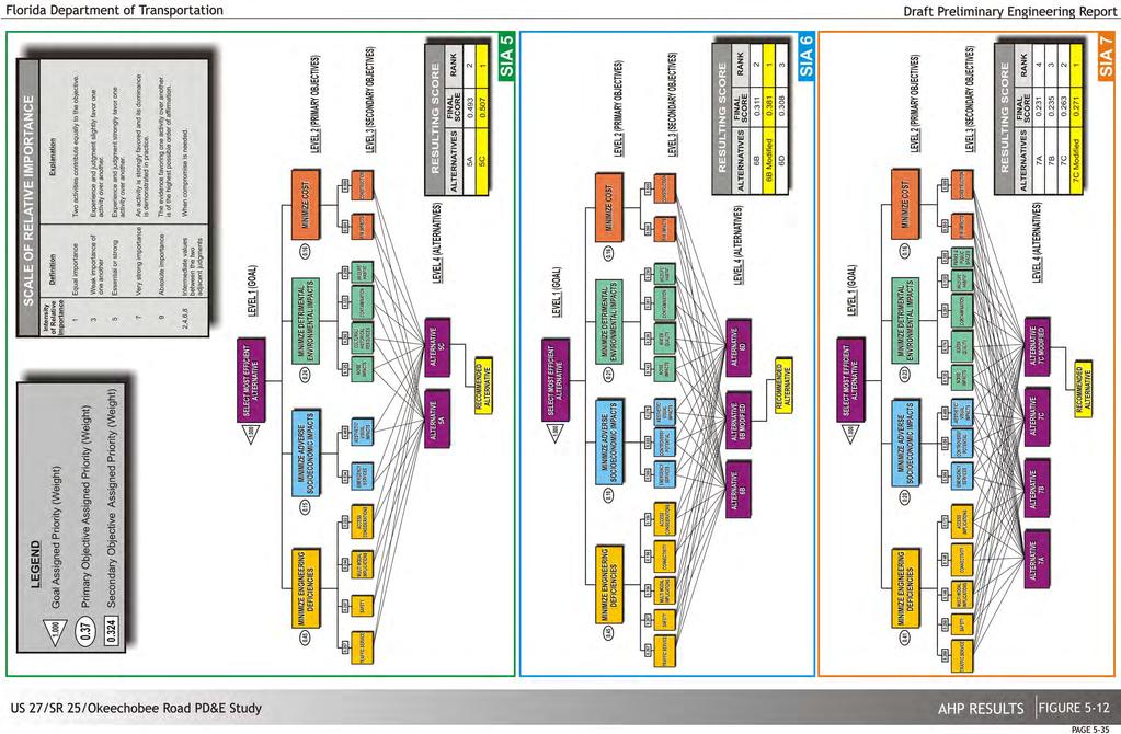
106

107
108 was According to the figure, the weight would need to be decreased to for alternative 5A to overtake alternative 5C. This drastic change is considered unreasonable since it will also significantly increase the relative importance of the other evaluation components (see table on the lower right hand side of the figure at the top). For example, under this scenario, the weight for the environmental component would be increased to or in other words, the relative importance of the environmental component would be almost 2.5 times more important than the engineering component in the total decision, an unacceptable high number. Similar unjustifiable results would be obtained under case 4 which would require a further increase of the cost component from its present assigned weight of to I n summary, alternative 5C is the top choice and is thus recommended. For SIA 6, all cases are insensitive. Alternative 6B Modified maintains its relative superiority regardless of a change in criteria weights since the lines representing the alternatives never meet. Thus, alternative 6B modified is recommended. The sensitivity results for SIA 7 illustrate a different scenario. All four cases are subject to sensitivity changes, but in case 1, it would take a change (a decrease in the assigned engineering deficiencies weight from to 0.332) for alternative 7B to overtake the highest ranked alternative (7C Modified). The table on the lower hand side of the figure shows what the resulting criteria reallocation would be for each. Under cases 2, 3 and 4, the required increases in the originally assigned weights would place the relative importance (weight) of the engineering decisional component below the socio-economic (case 2) or environmental (case 3) component or the cost component (case 4). connectivity, etc.) and addresses all of the project needs. When comparing alternative 7C Modified with alternative 7C, alternative 7C Modified is slightly better than alternative 7C due to the construction cost component. The FDOT has coordinated with all local municipalities (including City of Hialeah Gardens, City of Hialeah Gardens Police Department, Town of Medley, City of Hialeah, etc.) and major stakeholders as well as being presented at the Alternatives Workshop held March 27, 2014 and all comments were taken into consideration in the evaluation of alternatives. In all preliminary coordination meetings held, no opposition to alternative 7C Modified has been expressed by the public, stakeholders and public officials. In summary, alternative 7C Modified is the top choice and thus recommended. 5.4 Phase Four: Selection of Recommended Alternative Based on the evaluation of alternatives from an engineering, environmental, socio-economic and cost perspective as well as public comments received, the recommended alternatives are 1A, 2A, 3B, 4B, 5C, 6B Modified, 7C Modified, and 8B. Table 5-12 provides a summary of the alternative selection process and the reason for selection. (This space intentionally left blank) In summary, although alternative 7A and 7B avoid major environmental impacts their only focus is the Okeechobee Road operational improvements. However, since the future extension of NW 87 th Avenue across the Miami Canal will generate significant additional traffic that will impact the abutting local street network these two alternatives do not fully address the operational needs of the entire SIA and thus do not entirely meet the project objectives. Alternatives 7C Modified and 7C, on the other hand, although with some environmental impacts to local park facilities, does provide major enhancements in all engineering categories (traffic operations, safety, access, Alternatives Considered Draft Preliminary Engineering Report 5-37
109 SIA Table 5-12 Summary of SIA Evaluation Results Remarks Although both alternatives considered (1A and 1B) effectively address the existing deficiencies, alternative 1A also avoids impacting the access to the Miami-Dade County Aviation Department (MDAD) property. Access impacts to this parcel would result in higher right-of-way costs and significant controversy potential due to opposition from MDAD. Alternative 2A not only provides much needed aux iliary lanes, but also increases safety by reducing the number of potential conflict points. The relocation of access provision to land uses north of Okeechobee Road, away from the existing horizontal curve, is also a s afer condition than the other alternative considered. Alternative 3B provides additional distance between contiguous median openings as well as adequate acceleration and deceleration lanes for all movements. In general terms, this alternative promotes greater safety and better access management features than alternative 3A. The recommended alternative (4B) is similar to the alternative proposed for Florida s Turnpike Enterprise (FTE) Homestead Extension of Florida Turnpike (HEFT) PD&E Study. The only modification is the provision of an additional eastbound left turn lane to northbound HEFT ramp for operational reasons. Although alternative 5A and 5C provide adequate solutions to the many operational deficiencies within this SIA, 5C is slightly better because of the following reasons: 1) the widening of the NW 138 th Street bridge allows for the dual westbound/eastbound left turn lanes to turn concurrently; 2) the provision of a single southbound to westbound right turn lane at NW 138 th Street reduces the weaving distance to the HEFT northbound on-ramp. Although alternatives 6D and 6B Modified are s imilar from an oper ational standpoint, 6B Modified avoids reconstruction of NW S River Drive, two expensive skewed bridges over the Miami Canal as well as significant R/W and relocation impacts. Some of its most important advantages include the following: 1) the provision of a grade-separation of Okeechobee Road at NW 116 th Way in conjunction with a southbound to eastbound flyover will result in major operational and s afety improvements, addressing a major need; 2) the preservation of local connectivity and access connections are important features and reduce controversy potential. Four of the alternatives (7A, 7B, 7C and 7C Modified) are clearly superior to the other three considered options (7D, 7E and 7F). Although alternatives 7A and 7B avoid major environmental impacts (e.g. impacts to Bernie Wilson Park, Brothers to the Rescue Memorial, etc.), providing grade separations over NW 87 th Avenue and NW 103 rd Street alone without addressing the immediate surrounding network would result in a degradation of the access points on/off the mainline and c onsequently impact the operations of the mainline downstream from these points. These two alternatives do not fully address the operational needs of the entire SIA and thus do not entirely meet the project objective. Although alternatives 7C and 7C Modified have some environmental impacts to local park facilities, they do provide major enhancements in all engineering categories (traffic operations, safety, access, connectivity, etc.) and address all of the project needs. Alternative 7C Modified with Okeechobee Rd mainline at a t hird level results in lower construction costs and r educed flooding potential from proposed impacts to SFWMD C6 & C7 canals under alternative 7C. In addition, the relocation of NW 103 rd Street is an essential component of the efficient operational solution to the contiguous street network within this SIA. Although both alternatives considered (8A and 8B) are generally similar and effectively address the existing deficiencies, alternative 8B provides an addi tional access connection. This connection would serve high traffic generating land uses at the eastern end of Frontage Road. This feature provides an operational improvement along Frontage Road by removing vehicles from the heavily congested Frontage Road/NW 95 th Street intersection and it will likely avoid potential controversy from business owners complaining about the lack of adequate access to Okeechobee Road and associated safety concerns. Recommended Alternative 1A 2A 3B 4B 5C 6B Modified 7C Modified 8B Alternatives Considered Draft Preliminary Engineering Report 5-38
110 6. RECOMMENDED ALTERNATIVE The results of the Alternative Selection Process indicate that the recommended alternative is a combination of SIA alternatives 1A, 2A, 3B, 4B, 5C, 6B Modified, 7C Modified, 8B. The following sections describe and highlight the different design elements associated with the recommended alternative. For more details please see the concept plans in Appendix F Preliminary Roadway Design Proposed Typical Sections As was previously mentioned, Okeechobee Road has been designated an SIS facility and serves as a restrictive highway due to the lack of access points and the presence of a frontage road. From Krome Avenue to the Florida's Turnpike northbound on ramp (SIAs 1-4) the recommended alternative generally keeps the same typical section with operational improvements in the form of acceleration and deceleration lanes at all major intersections as well as radius improvements for large trucks. The recommended improvements from east of the HEFT to NW 79 th Avenue require reconstruction of Okeechobee Road. Just west of NW 116 th Way (SIA 6), the recommended alternative proposes an elevated four lane section over NW 116 th Way with ramps to/from Frontage Road and NW S River Drive. Additionally, a third-level fly over ramp from southbound NW 116 th Way to eastbound Okeechobee Road is provided. Within SIA 7, the recommended alternative recommends Okeechobee Road s mainline as a third level over NW 87 th Avenue and provides service roads for the local movements to NW 87 th Avenue. Additionally, it provides two flyover ramps from northbound/southbound NW 87 th Avenue to westbound/eastbound Okeechobee Road. The only SIA that adds additional through lanes along Okeechobee Road is SIA 8, which adds an additional lane in each direction from west of NW 95 th Street to NW 79 th Avenue. More details on the proposed typical sections are displayed in the typical sections package (Appendix F1). Table 6-1 Proposed Horizontal Curves Location Curve PC STA PI STA D Delta L (ft) R (ft) East of NW 186 th St BL '58'22" 48'17'17" (LT) 1, , EB A '58'24" 18'40'38'' (LT) Okeechobee Rd A '41'46'' 0'20'28'' (LT) , near NW 116 th A '21'43'' 20'36'43'' (RT) Way A '29'21'' 17'26'27'' (LT) WB Okeechobee Rd B '14'57'' 2'17'49''(RT) ,000 near NW 116 th Way B '08'13'' 1'16'52'' (LT) , NW 116 th Way C '00'19'' 0'00'35'' (RT) ,113, NW 116 th Way D '59'59'' 2'29'35'' (LT) ,865 SB-EB Flyover D '47'16'' 89'59'09'' (LT) 1, Ramp D '08'39'' 1'56'42 (LT) 1, , D '08'39'' 0'25'43'' (LT) , NW 87 th Ave NB-WB Flyover Ramp Okeechobee Rd West over NW 87 th Avenue NW 87 th Ave SB-EB Flyover Ramp F '17'31" 3'14'39" (RT) F '54'01" 4'00'00" (RT) F '02'57" 49'08'41" (RT) F '46'55" 9'02'49" (RT) F '51'15" 7'41'31" (RT) G '13'45" 1'10'57" (RT) H '02'00" 2'05'19" (RT) H '32'57" 13'29'37"(RT) H '32'09" 66'49'44" (LT) NW 106 th St I '24'24" 50'27'18" (LT) Horizontal Alignment Table 6-1 summarizes the horizontal curve data proposed for the recommended alternative (curve data is displayed on the concept plans in Appendix F2). Recommended Alternative Draft Preliminary Engineering Report 6-1
111 6.1.3 Vertical Alignment Table 6-2 summarizes the vertical curve data proposed for the recommended alternative (curve data is displayed on the concept plans in Appendix F2). Location NW 116 th Way SB-EB Flyover WB Okeechobee Rd (mainline) over NW 116 th Way EB Okeechobee Rd (mainline) over NW 116 th Way Okeechobee Rd (mainline) Third Level over NW 87 th Ave NB NW 87 th Ave to WB Okeechobee Rd Flyover SB NW 87 th Ave to EB Okeechobee Rd Flyover Table 6-2 Proposed Vertical Curves Type of Curve VPI Station (ft) VPI Elevation Bicycle and Pedestrian Accommodations Grade (Back) % Grade (Ahead) % Length of Curve (ft) Sag Crest Crest Sag Sag Crest Crest Crest Sag Sag Crest Crest Sag Sag Sag Crest , Sag Sag Crest Crest Sag Sag Crest Sag Pedestrian and bicycle facilities are an important part of Florida's state road system and thus have been incorporated as part of the recommended alternative. Coordination with the State Bicycle/Pedestrian Coordinator determined that a k eyhole design would be provided at the deceleration lanes. At the acceleration lanes being provided, the bicyclists are to transition to the shoulder once across an i ntersection; a k eyhole should not be provided. Additionally, the State Bicycle/Pedestrian Coordinator recommended that Roadway Design Bulletin 14-17, which calls for K the provision of 7 foot bicycle lanes/ paved shoulders (released September 9, 2014) be implemented in this project. However, the recommended alternative was presented to multiple Miami Dade County MPO Committees including the Citizen's Advisory Committee, Bicycle and Pedestrian Advisory Committee, Freight Transportation Advisory Committee, Transportation Aesthetics Review Committee and the Transportation Planning Council. All committees expressed concern regarding the safety of the bicyclists if designated bicycle lanes are provided along the shoulder of Okeechobee Road due to the high heavy truck percentage (more than 15%) and high design speed (65-60 mph). All of the MPO committees requested that the FDOT not provide bicycle lanes along Okeechobee Road. Due to safety concerns and p ublic opposition it was decided by the District Design Engineer to provide the required spacing for a bicycle facility without the required pavement markings. The proposed conditions will provide seven (7) foot paved shoulders with a seven (7) foot buffer between the outside travel lane and the turn lanes, with no markings for bicycle lanes. See Concept Plans in Appendix F2. Continuous sidewalks are also being provided along the north side of the Frontage Road east of the HEFT. Additionally, proper pedestrian crossings will be provided across all cross streets. As part of a separate effort, the Town of Medley is proposing to implement sidewalks along the south side of NW S River Drive and i mprovements being proposed as part of this PD&E at NW S River Drive include connections to future pedestrian facilities. Thus, crosswalks across Okeechobee Road are being proposed at all cross streets that connect Frontage Road and NW S River Drive (NW 116 Way and NW 87 Avenue) Access Management The access management class for Okeechobee Road is not proposed to be changed as a result of the recommended alternative. The recommended alternatives does, however, propose the closure of two unsignalized median openings, at the Frontage Road access (west of NW 170 th Street) and at NW 127 th Avenue. A right only will be maintained at the Frontage Road access. A new median opening and access is proposed just west of NW 127 th Avenue at NW 129 th Avenue in order to provide access to the abutting properties. These changes in access are critical in order to provide Recommended Alternative Draft Preliminary Engineering Report 6-2
112 the necessary acceleration and deceleration lanes in all directions at these locations and to comply with access management criteria. Additionally, the proposed alternative will relocate the existing bridge crossing and s ignal at NW 105 th Way to NW 106 th Street. The relocation of this access will correct the existing weaving deficiencies within the Town of Medley at the existing bridge and will also allow for the proper development of the Okeechobee Road 3rd level overpass over NW 87 th Avenue. Lastly, as part of the NW 87 th Avenue extension project (FM# ) a new signal at Okeechobee Road on NW 87 th Avenue will be introduced. Alternative 7C Modified proposes to close the access to/from NW 103 rd Street at Okeechobee Road along with the previously mentioned improvements. Table 6-3 provides a summary of the proposed access changes along Okeechobee Road. Table 6-3 Proposed Median Opening Changes Existing Median Opening/Access Proposed Change Remarks Potential Design Exceptions and Variations A bicycle lane variance was submitted and approved by the District Design Engineer and is included in Appendix F3. This variance was also coordinated with the State Bicycle/Pedestrian Coordinator. For the areas that a bicycle lane is not proposed a design variation will be required from the Town of Medley for NW South River Drive and from Miami Dade County for NW 116 th Way, NW 138 th St, and NW 87 th Avenue. Border and median width variances for Okeechobee Road are also required, more details can be found in the Design Variations Memorandum (Appendix F3). It should be noted that during this study, concerns were raised regarding the existing fence located between Frontage Road and Okeechobee Road. Currently, the reason for the installation of the fence is unclear; it may have been installed to prevent vehicles from deliberately traversing the grass swale in order to avoid delays at the signalized intersections. Different solutions were considered including preparation of a design variance for recoverable terrain and/or a lateral offset design exception, removal of the fence, installation of guardrail to protect vehicles from striking the fence and relocation of the fence closer to Frontage Road. It was decided to evaluate the different options during the design phase. Please refer to meeting minutes in Appendix A3. Frontage Road access road at Okeechobee Road NW 127 th Avenue at Okeechobee Road NW 105 th Way Close Median opening, provide right-out only Close median opening and access to Okeechobee Road New access at NW 106 th Street, closure of access at NW 105 th Way Allows development of adequate acceleration/deceleration lanes and turning radius at NW 170 th Street Access to abutting properties provided via Frontage Road New Access provided just to the west at NW 129 th Avenue which allows for development of adequate acceleration/deceleration lanes at NW 129 th Avenue and NW 154 th Street Access to NW 105 th Way is via NW 106 th Street, thus the bridge over the Miami Canal and its access to Okeechobee Road are shifted to NW 106 th Way to eliminate weaving 6.2 Traffic Analysis Development of Future Traffic Projections Traffic demand modeling was performed using Florida s Southeast Regional Planning Model (SERPM) version 6.5. Separate SERPM models were developed for the No-Build and the various alternatives for each of the opening year (2020), interim year (2030) and design year (2040). This section will summarize the findings of the No-Build and recommended alternative. For more detailed traffic information on the eliminated alternatives please refer to the Design Traffic Technical Memorandum (DTTM), a companion document to this Preliminary Engineering Report. NW 103 rd Street at Okeechobee Road Close median opening and access to Okeechobee Road Allows for development of Alternative 7C Modified and best operational performance in area. The No-Build Alternative includes all improvements programmed for construction in FDOT s Work Plan, MPO/FDOT s Long Range Transportation Plan (LRTP), cities comprehensive plans, and committed future roadway improvements by private developers for Developments of Regional Impact (DRI). DRI committed improvements were obtained from the South Florida Regional Recommended Alternative Draft Preliminary Engineering Report 6-3
113 Planning Council (SFRPC). A sub-area model refinement for the study area was performed using SERPM 2005 Validated base year model. The base year validated model was first corrected for the study area to create an adjusted validated model for The adjusted validated model was then refined for the project subarea to develop a sub-area refined SERPM model. Statistical analysis based on the Root Mean Square Error (RMSE) was performed to ensure a good correlation between traffic counts and model forecasts at count locations for the base year Future AADTs Future AADTs for roadway segments and intersection approaches were developed for each analysis year using two methods. The first method consists of comparing future AADTs to Base Year AADTs to develop annual compounded growth rates and then calculating future AADTs for each road segment by applying the corresponding compounded growth rate to existing AADTs. The second approach consists of simply reading future AADTs from the SERPM model outputs. Results from both methods were checked with growth estimates using the trend analysis method. However, since historical counts have not yet fully recovered from the recent dip (in 2009), the trend analysis exercise based on historical counts was of limited benefit for the study area. regional growth rate. The annual Okeechobee Road/regional compounded growth rate was rounded to 2% and applied to roadways and intersection approaches not included in the model. The annual growth rates using Method 1 and the resulting intersection approach AADTs for all future years are provided in the DTTM along with the SERPM AADT plots for all future years Future Intersection Volumes The Directional Design Hour Volumes (DDHV) were calculated by applying the Standard K, D 30 factor to the AADTs. The intersection volumes were developed using TMTOOL, a tool which establishes turning movements using the existing AADTs, existing turning percentages and t he established growth factors to project the future daily traffic demands for the years 2020 (opening year), 2030 (mid-term year), and 2040 (design year). Future projected turning movement volumes were manually adjusted to balance the volumes within the adjacent intersections. Figures 6-1 through 6-7 summarize the peak hour intersection volumes developed for the No Build and recommended alternative at each SIA. It should be noted that no turning movement counts were taken within SIA 2 due to its perceived absence of operational problems. The recommended AADT, K, D and T factors are provided in Table 6-4. Method 1 is the best approach for a number of reasons considering the characteristics of the study area and the SERPM network. The SERPM network does not include the Frontage Road and several intersection approaches are also missing from the network. F urthermore, the centroid connectors used to load zonal trips onto the network do not provide a good representation of local roadways within the study area. Traffic assignment on less important roadways can vary by over 30% to 50% or more since the validation process did not have traffic counts on non-state roads and bridges. Using AADTs directly from the model (Method 2) will cause inconsistent growth rates throughout the network. It should be noted that while Method 1 provides more reasonable and consistent results, the AADTs generated using Method 2 might be useful at few locations especially for new roads or connections; or where Method 1 forecasts are considered not reasonable. The growth rate for the Frontage Road and intersection approaches missing from the network were assumed equal to the overall growth rate of Okeechobee Road which was similar to the average This space was left blank intentionally. Recommended Alternative Draft Preliminary Engineering Report 6-4
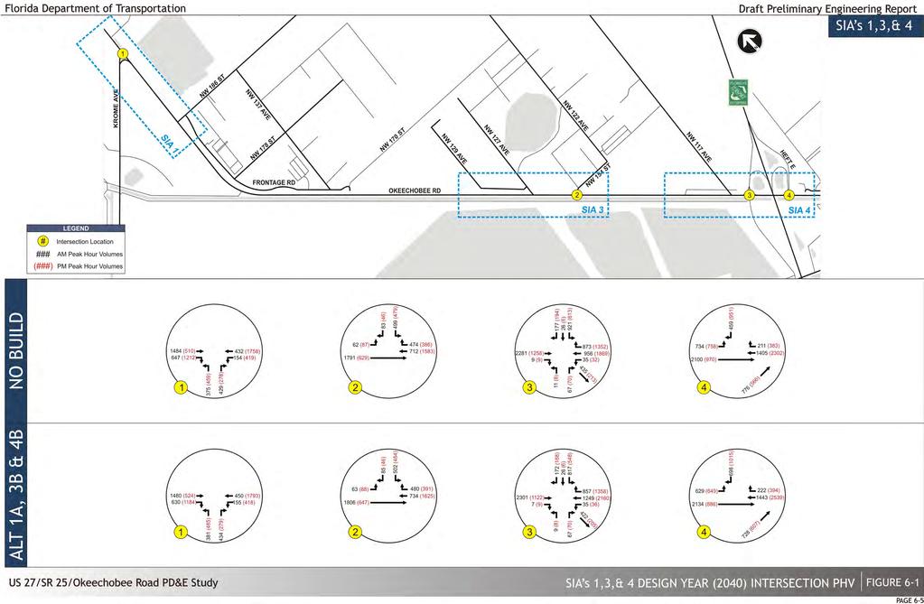
114

115 This space was left blank intentionally. Recommended Alternative Draft Preliminary Engineering Report 6-6


116 Recommended Alternative Draft Preliminary Engineering Report 6-7

117

118
119
120 Table 6-4 Recommended Traffic Factors Road Segment Standard K Factor D Factor T Factor Okeechobee Road (from Krome Avenue to SR 821/HEFT) Okeechobee Road (from SR 821/HEFT to NW 103 rd Street) Okeechobee Road (from NW 103 rd Street to NW 79 th Avenue) SR 821/HEFT SB On/Off Ramps SR 821/HEFT NB On/Off Ramps SR 997/Krome Avenue SR 997/Krome Avenue Ramps to NB/SB Okeechobee Road SR 932/NW 103 rd Street Frontage Road 9.0 n/a 4 NW S River Drive 9.0 n/a NW 154 th Street NW 118 th Avenue 9.0 n/a 40 NW 138 th Street NW 107 th Avenue 9.0 n/a 26 NW 121 st Way 9.0 n/a 26 NW 116 th Way/Hialeah Gardens Boulevard NW 105 th Way 9.0 n/a 40 NW 87 th Avenue 9.0 n/a 6 NW 95 th Street 9.0 n/a 6 NW 79 th Avenue 9.0 n/a Future Operational Analysis The roadway network for the No-Build/Build scenarios includes the following system modifications identified from Miami-Dade County Metropolitan Planning Organization Transportation Improvement Program (TIP): widen NW 87 th Avenue to 4-lanes with extension to connect from NW 74 th Street through to the Frontage Road and NW 103th Street, including a new bridge over the Miami Canal; widen NW 82 nd Avenue/W 24 th Avenue north of NW 103 rd Street; construct a new 6-lane NW 74 th Street between SR 826 and HEFT; add managed lanes to SR 826, and extend Gratigny Parkway west from I-75 to HEFT. The three Build network alternatives are composed of the following components: Build 1 (Alternatives 1B, 3B, 4A, 5A, 6B, 7A and 8A), Build 2 (Alternatives 1A, 3A, 4B, 5B, 6D, 7C and 8A/8B) and Build 3 (Alternatives 1A, 3A, 4B, 5C, 6D, 7C/7C Modified and 8A/8B) Intersection Analysis The intersection analysis was conducted using Synchro 8. Synchro optimizes traffic signal timing and performs capacity analysis for individual intersections, an arterial, or a complex network. It also provides outputs such as volume to capacity ratios, LOS, delays and queue lengths. The Synchro analysis included all major intersections within the project area of influence. A separate Synchro file was established for each target year and peak hour under all future scenarios. Along with No-Build, the analysis results have been summarized in Table 6-5 according to the SIAs previously established. For the No-Build alternative, the roadway network was assumed to remain the same as existing with the system modifications discussed previously. In addition, signal timing optimization was performed for each intersection in the future. In general, the results reflect that west of the HEFT capacity improvements aren t as critical as they are to the east. Outside the urban development boundary the recommended alternative generally meets the adopted LOS C standard west of HEFT for the thru movements along Okeechobee Road and at the intersections. Overall intersection delays within SIAs 1 and 3 that do not meet the LOS standard are Okeechobee Road and Krome Avenue during the PM peak hour under the No Build alternative and Okeechobee Road at NW 154 th Street during the PM peak hour under the No Build alternative. SIA 4 encompasses the improvements from the HEFT PD&E Study previously mentioned and operates at acceptable levels throughout the analysis year 2040 and time of day with the exception of Okeechobee Road at the HEFT eastbound on ramp during the PM peak hour in the year For SIA 5, the No-Build option would generally operate adequately until 2030 (with the exception of the Okeechobee Road at NW 138 th Street intersection). However, heavy congestion would be prevalent by the design year resulting in an unacceptable LOS for the intersections of Okeechobee Road at NW 138 th Street, Frontage Road at NW 138 th Street and Okeechobee Road at NW 107 th Avenue. Alternative 5C would provide much lower delays as compared to No Build, however the intersection of Okeechobee Road at NW 138 th Street will still operate at an unacceptable level of service. It should be noted that although Alternative 5B provides better operational results than Alternative 5C, it affords a very short weaving distance for the traffic from NW 138 th Street and NW 107 th Avenue destined to the HEFT. Recommended Alternative Draft Preliminary Engineering Report 6-11
121 Table 6-5 Intersection LOS Summary (Year 2040) Table 6-5 Intersection LOS Summary (Year 2040) (Cont'd) SIA Intersection 1 Okeechobee Rd & Krome Ave 3 Okeechobee Rd & NW 154 St Okeechobee Rd & NW 118 Ave/ SR 821 Okeechobee Rd & HEFT E Frontage Rd & NW 138 St Okeechobee Rd & NW 138 St Okeechobee Rd & NW 107 Ave NW South River Dr & NW 127 St Okeechobee Rd & NW 121 Way NW South River Dr & NW 121 Way Okeechobee Rd EB Off-Ramp & Frontage Road Okeechobee Rd WB On-Ramp & Frontage Rd Okeechobee Rd WB Off-Ramp & Frontage Road Frontage Rd & Hialeah Gardens Blvd Okeechobee Rd & NW 116 Way/Hialeah Gardens Blvd NW 122 St & NW 92 Ave Frontage Rd & NW 92 Ave NW South River Dr & NW 116 Way NW South River Dr & NW 122 St LOS below adopted LOS C standard. LOS below adopted LOS D standard. No signal Peak Period 2040 Analysis Scenario No Build Recommended Build AM C C PM E C AM B B PM E C AM D C PM D D AM B B PM E E AM F C PM E D AM E E PM F F AM F D PM F C AM A A PM A A AM F E PM C C AM F C PM D B AM A PM B AM C PM B AM C PM D AM F C PM F C AM F PM F AM F F PM F F AM F B PM F B AM E C PM C C AM B B PM B B SIA 7 8 Intersection Okeechobee Rd & NW 105 Way Okeechobee Rd & NW 106 St NW South River Dr & NW 105 Way NW 87 Ave & NW 103 St Frontage Rd & NW 103 St Frontage Rd & NW 87 Ave Okeechobee Rd & NW 103 St Okeechobee Rd & NW 87 Ave NW South River Dr & NW 87 Ave NW 87 Ave & NW 106 St NW 87 Ave & NW 114 St NW South River Dr & NW 106 St Frontage Rd & NW 95 St Connector Okeechobee Rd & NW 95 St Connector Okeechobee Rd & NW 79 Way NW South River Dr & NW 79 Ave/ NW 79 Way Frontage Rd & NW 95 St LOS below adopted LOS C standard. LOS below adopted LOS D standard. No signal 2040 Analysis Scenario No Build Recommended Build AM F PM E AM F PM D AM E D PM F C AM F D PM F D AM F PM F AM F D PM F E AM F PM D AM F E PM F E AM F E PM F E AM F PM F AM D D PM D D AM F D PM C D AM C C PM E C AM C C PM E B AM F D PM F E AM F D PM F E AM F C PM F D Peak Period Recommended Alternative Draft Preliminary Engineering Report 6-12
122 For SIA 6, the No-Build option would result in high delays throughout most intersections by 2030 with forced flow conditions by the design year. Alternative 6B Modified would yield acceptable levels of service for all intersections with the exception of Okeechobee Road/NW 121 st Way during the AM peak hour, and NW 122 nd Street at NW 92 nd Avenue during the AM and PM peak hours. For SIA 7, No-Build option would result in high delays throughout most intersections by 2030 with forced flow conditions by the design year. According to the results obtained in Alternative 7C Modified only the AM peak delays for the Okeechobee Road/NW 106 th Street intersection would fail with a LOS F. It should be noted that the alternative provides a significant improvement to the No Build option at these intersections (i.e. the 2040 No Build option at the NW 87 th Avenue/NW 103 rd Street intersection would result in a d elay of seconds compared to 38.4 seconds with Alternative 7C modified). Build network, the travel speed measure of effectiveness becomes outweighed by the networks inability to process the demand. 6.3 Structural Analysis The following sections serve to provide a preliminary structural analysis of all existing and proposed bridges. The concept plans in Appendix F2 include the proposed structural plans. Table 6-7 provides a summary of the proposed structures as well as the proposed improvements to existing structures. For SIA 8, No-Build option would result in high delays and failing LOS at the Okeechobee Road/NW 79 th Way intersection in opening year. As expected, alternative 8B generates better results Segment and Network Analysis VISSIM model runs were performed for the recommended alternative for opening (2020), interim (2030) and design (2040) years. The traffic conditions were evaluated based on simulation outputs and summary data related to speed, travel time and processed volumes. Travel speed and processed volume results for are summarized in Table 6-6. Based on the network summary tables, motorists traveling eastbound from Krome Avenue to HEFT would experience travel speeds all within acceptable levels of service during all analysis years. However, due to the projected increase in volumes and directional peaks, westbound traffic would experience speeds below the adopted threshold during the PM peaks. This space was left blank intentionally. In general terms, travel speeds along Okeechobee Road east of HEFT in the No Build option operate below acceptable thresholds throughout all analysis years. Improvements along Okeechobee Road such as grade separation and turbo lanes along the mainline reduce the disruption of traffic flow throughout the project corridor thus resulting in higher levels of service. It should be noted, that although some results of the No Build network are superior to those in the Recommended Alternative Draft Preliminary Engineering Report 6-13
123 Direction Eastbound Table 6-6 Segment MOE Summary (Year 2040) Road Segment Krome Ave to NW 154 St NW 154 St to HEFT West Turnpike West to HEFT East Turnpike East to NW 138 St NW 138 St to NW 107 Ave NW 107 Ave to NW 121 Way NW 121 Way to NW 116 Way NW 116 Way to NW 105 Way NW 105 Way to NW 103 St NW 103 St to NW 95 St NW 95 St to NW 79 Ave New Elevated US 27 (NW 87 Ave to HGB) Krome Ave to NW 79 Ave Peak Period Proc Vol Analysis Scenario No Build Recommended Build AVG Speed LOS Proc Vol. AVG Speed AM A B PM A A AM B B PM B B AM C B PM B A LOS AM E D PM D D AM C E PM B C AM D F PM F B AM F B PM F B AM E D PM D C AM F A PM F A AM B A PM B A AM C F PM C D AM C PM B AM C C PM D B AM E E HEFT West to NW 79 Ave PM E B *LOS using HCM thresholds and Vissim speeds are provided for informational purposes only ** It should be noted that no-build conditions are so saturated that the network processes substantially less vehicles than the build condition. Thus, it falsely shows from a travel time perspective that it is superior to the build option at various locations LOS below adopted LOS C standard. LOS below adopted LOS D standard. Direction Westbound Table 6-6 Segment MOE Summary (Year 2040) (Cont d) Road Segment NW 79 Ave to NW 95 St NW 95 St to NW 103 St NW 103 St to NW 105 Way NW 105 Way to NW 116 Way NW 116 Way to NW 121 Way NW 121 Way to NW 107 Ave NW 107 Ave to NW 138 St NW 138 St to HEFT East Peak Period Proc Vol Analysis Scenario No Build Recommended Build AVG Speed LOS Proc Vol. AVG Speed LOS AM C B PM F B AM C A PM F A AM F C PM E A AM D A PM E A AM B B PM B B AM B A PM B A AM D C PM E C AM C C PM C C HEFT East to HEFT West AM D D PM D B HEFT West to NW 154 St AM B A PM C B NW 154 St to Krome Ave AM B B PM B C New Elevated US 27 AM B (NW 87 Ave to HGB) PM A NW 79 Ave to Krome Ave AM C B PM D B NW 79 Ave to HEFT West AM D B PM E B *LOS using HCM thresholds and Vissim speeds are provided for informational purposes only LOS below adopted LOS C standard. LOS below adopted LOS D standard. Recommended Alternative Draft Preliminary Engineering Report 6-14
124 No. Bridge ID No. Bridge Name Direction Facility Crossed Table 6-7 Proposed Recommendations for Structures Super Structure Type Sub- Structure Type NW 138th St over Miami Canal EB/WB C-6 Canal Flat Slab 18" Pile Bents NW 107th Ave over Miami Canal NB/SB C-6 Canal AASHTO Type II Beams 18" Pile Bents NW 121st Way over Miami Canal NB/SB C-6 Canal Flat Slab 18" Pile Bents 4 B-4* SB NW 116th Way to EB Okeechobee Rd Flyover 5 B-5* WB Okeechobee Rd over EB Off Ramp WB SB NW 116th Way, Frontage Road, WB Okeechobee Rd EB Off Ramp at NW 116th Way Steel Plate-I Girders, Steel Plate Box Girders, Segmental Units, & Post-Tensioned Curved Concrete Girders has been considered Radial Single Column Piers, Integral Steel Straddle Pier Cap Bridge Width (ft) Varies Varies Varies min. Bridge Length (ft) No. of Spans Span Lengths Min. Vertical Clear. OWS / DWS (ft)** Min Horizontal Clearance Ft Ft Ft Summary / Bridge Widening / Bridge Widening , 38.17, / , , , , , , Florida-I 72 Beam 18 Pile Bents B-6* WB Okeechobee Rd over NW 116th Wy WB NW 116th Way Florida-I 72 Beam 18 Pile Bents B-5* WB Okeechobee Rd over EB On Ramp WB 8 B-8* EB Okeechobee Rd over EB Off Ramp EB EB On Ramp at NW 116th Way EB Off Ramp at NW 116th Way Florida-I 72 Beam 18 Pile Bents Florida-I 96 Beam 18 Pile Bents B-7* EB Okeechobee Rd over NW 116th Wy EB NW 116th Way Florida-I 72 Beam 18 Pile Bents B-7* EB Okeechobee Rd over EB On Ramp EB EB On Ramp at NW 116th Way NW 116th Way over Miami Canal NB/SB C-6 Canal Flat Slab 18" Pile Bents 12 B-12* NW 106th Street over Miami Canal NB/SB C-6 Canal 20" Solid CIP Slab 18" Sq. Piles 13 B-13* 14 B-14* NB NW 87 Ave to WB Okeechobee Road Flyover SB NW 87 Ave to WB Okeechobee Road Flyover 15 B-15* Okeechobee Rd over NW 87th Ave EB/WB NB SB NW South River Dr., C-6 Canal, Okeechobee Rd Frontage Rd, N Okeechobee Rd NW 87th Ave, NB NW 87th Ave flyover, SB NW 87th Ave flyover Florida-I 72 Beam 18 Pile Bents Steel Plate-I Girders, Steel Plate Box Girders, & Concrete Segmental Box Girders has been considered Steel Plate-I Girders, Steel Plate Box Girders, & Concrete Segmental Box Girders has been considered Florida-I 72 Beam, and Steel Plate Girders or Steel Boxes Radial Single Column Piers, Integral Steel Straddle Pier Cap Radial Single Column Piers, Integral Steel Straddle Pier Cap Multicolumn Piers and Hammer Head Type Piers Varies 105 min. Varies min , 38.59, / Bridge Widening, Addition of a through lane, Superstructure replacement New Structure, (1) 15' lane New Structure Overpass New Structure Overpass New Structure Overpass New Structure Overpass New Structure Overpass New Structure Overpass Slab Reconstruction and Widening / New Structure , , , , , , at , 1 at New Structure, (1) 15 lane New Structure, (1) 15 lane New Structure NW 79th Ave over Miami Canal NB/SB C-6 Canal Flat Slab 18" Pile Bents , 40.00, / Bridge Widening NW 105th Way over Miami Canal SB C-6 Canal Flat Slab/ Pre. Slab Units 18" Pile Bents NW 105th Way over Miami Canal NB C-6 Canal Flat Slab/ Pre. Slab Units 18" Pile Bents *See Plan Sheet Number in the Concept Plans located in Appendix F **Only applies for bridges over the Miami Canal Structure to be Demolished Structure to be Demolished Recommended Alternative Draft Preliminary Engineering Report 6-15
125 HEFT Bridges over Miami Canal and Okeechobee Road As mentioned in Section 3, the existing pier columns are within the setback distance and are not theoretically capable of resisting a vehicular impact force of 600 kips. As per the Structures Design Guidelines Section C.2, pier protection barriers following Index 411 or other TL-5 barriers should be evaluated to shield the existing columns for the following reasons: These bridges are considered to be critical since Florida s Turnpike is a high speed limited access facility Due to the heavy truck traffic along Okeechobee Road The calculated annual frequency for pier impact is greater than This can be further evaluated during final design. For purposes of this preliminary evaluation, the AASHTO Type II beams at a similar spacing as the existing beam were chosen for the widening. It is recommended to provide intermediate diaphragms to maintain the same type of framing as the existing bridge such that the stiffness of the bridge is maintained consistent between the existing and widened sections. Widening is being proposed on both the west and east fascias of the bridge. The west fascia improvements will allow for a greater shoulder for the traffic from eastbound Okeechobee Road making a r ight turn onto NW 107 th Avenue. The existing plans show that the transverse reinforcing along the west fascia consists of #4 size reinforcing bars at 5¼ spacing. 1. NW 138th Street over the Miami Canal (Bridge No ) Proposed improvements at this bridge include bridge widening in order to accommodate two WB-62FL trucks turning from westbound Okeechobee Road to southbound NW 138 th Street (dual eastbound/westbound left turn lanes proposed along Okeechobee Road at NW 138 th Street). The bridge was built in 2012 with a 20-inch flat slab and 18-inch pile bents. Major reconstruction of the existing superstructure would be required to adequately provide sufficient room for the reinforcing steel in a reinforced concrete flat slab. This should be further evaluated during the preparation of the Bridge Development Report. See sheets B1-1 and B1-2 of the concept plans for more details on this bridge. 2. NW 107th Avenue over Miami Canal (Bridge No ) This bridge is to be widened utilizing AASHTO Type II beams. Two beam options are viable, AASHTO Type II and Florida FIB-36. Due to the complexity of the beam framing, a tighter beam spacing that matches the original beam design is preferred. FIB-36 beams will not be efficiently used unless larger beam spacing is utilized, thus there is a potential for adding more load on the widened deck slab since it would distribute the loading to the beams. However, although the FIB-36 beams may have adequate strength, there could be a greater differential stiffness between the existing AASHTO Type II beams and the proposed FIB-36. This reinforcing is insufficient to carry the traffic barrier impact loads from the barrier to the deck slab associated with a T L-4 loading. Therefore, the deck slab needs to be removed from the centerline of the first interior beam such that enough reinforcing is placed in the first interior bay that continues onto the overhang that will satisfy the requirements of the Structures Design Guidelines for deck reinforcing at the overhangs for TL-4 loading. I n addition, the overhang increases in Span 3 to approximately 9-9 due to the turning radius, therefore, the fascia beam is expected to be replaced due to the higher loads associated with the larger overhang. To avoid a vertical clearance variation, modified type II beams may be required to meet the minimum of 2 feet of vertical clearance at End Bent 4. The east fascia widening improvements will provide a flared 8 inch concrete deck which allows trucks to turn on a flatter curve for the traffic movement turning onto Okeechobee Road eastbound. However, a c oncern with the flare at this location is that the width of the deck increases substantially as you travel the length along the flares diaphragms. Since the AASHTO beams will chord the flare, it is important to limit the increase in deck width that occurs with the use of the flare. The increase in width will cause the cantilever overhang to vary along the beam. Therefore, End Bent 4 widening is proposed to be angled towards Bent 3. This allowed for the cantilever overhang at End Bent 4 to be limited to a designable length (approximately 5 feet). Due to the flare, the cantilever length quickly decreases along the beam to a minimum of 18 inches from the centerline of the beam. During final design, the required spacing of the proposed beams can be determined based on load rating calculations of both the proposed and Recommended Alternative Draft Preliminary Engineering Report 6-16
126 existing exterior bridge beams that become interior beams after the widening. See sheets B2-1 and B2-2 of the concept plans for more details on this bridge. 3. NW 121st Way over Miami Canal (Bridge No ) Proposed improvements at this bridge include the addition of a through lane in the southbound direction, and larger turning radius for truck movements to and from South River Drive and Okeechobee Road. In order to accommodate these improvements, bridge widening and superstructure replacement options were considered. The existing bridge was originally built in 1970 with prestressed slab units and was then widened to both sides in 1990 with a reinforced concrete flat slab. Reinforced concrete flat slab superstructure would be the viable option for the proposed widening due to the curved horizontal geometry. Flat slabs will also maintain a l ow vertical profile over the canal. The proposed bridge width will vary significantly throughout the entire bridge length to accommodate the improved turning radii. Major reconstruction of the existing superstructure would be required to adequately provide sufficient room for the reinforcing steel in a reinforced concrete flat slab. Retrofitting or widening of prestressed slab units is also not desirable by the Department and approval from the State Structures Engineer will be required due t o the poor performance of these types of superstructures and significant maintenance required. Because of this reconstruction and mix of existing superstructure types, it is recommended to replace the entire superstructure. The existing substructure is in satisfactory condition and can be evaluated to support the proposed superstructure. In addition, the increased bridge width would require the existing profile to be raised to meet the required vertical clearances over the Miami Canal set forth by SFWMD. For these reasons, complete superstructure replacement with a r einforced concrete slab is recommended. This should be further evaluated during the preparation of the Bridge Development Report. See sheets B3-1 and B3-2 of the concept plans for more details on this bridge. Within SIA 6 there are 6 new bridge structures proposed as part of alternative 6D: 4. Southbound NW 116th Way to eastbound Okeechobee Road Flyover: The bridge will serve as a direct connection between SB NW 116th Way to EB Okeechobee Road and will carry one (1) 15-0 lane, 6-0 shoulders and 1-6½ barriers for a total bridge width of The proposed bridge length is ¾ consisting of nine (9) spans with varying lengths. Superstructure options to be considered in the Bridge Development Report include steel plate-i girders, steel plate box girders, segmental units and p ost-tensioned curved concrete girders. Radial single column piers shall be considered for the substructure type. Integral pier caps will most likely be r equired for the spans over Okeechobee Road. There are existing overhead power lines that will be in conflict with the construction of the proposed flyover and will need to be relocated. See sheets B4-1 through B4-5 of the concept plans for more details on this bridge. 5. Westbound Okeechobee Road over the EB Off Ramp: The proposed overpass will carry two (2) 12-0 lanes, 10-0 outside shoulder, 6-0 inside shoulder and 1-6 ½ barriers for a total bridge width of Using wrap around MSE walls at the abutments, the proposed bridge length is with little skew and c an span the ramp with a s ingle span. With this span length, Florida-I beams will m ost likely be the preferred superstructure type due to their economy, ease of construction, and acceptable aesthetics. Based on the span length, Florida-I 72 beams would be the most cost effective beam type for this bridge. See sheets B5-1 through B5-3 of the concept plans for more details on this bridge. 6. Westbound Okeechobee Road over NW 116th Way: The proposed overpass will carry two (2) 12-0 lanes, 10-0 outside shoulder, 6-0 inside shoulder and 1-6 ½ barriers for a total bridge width of Using wrap around MSE walls at the abutments, the proposed bridge length is with little skew and c an span NW 116 th Way with a single span. With this span length, Florida-I beams will most likely be the preferred superstructure type due to their economy, ease of construction, and acceptable aesthetics. Based on the span length, Florida-I 72 beams would be the most cost effective beam type for this bridge. See sheets B6-1 through B6-3 of the concept plans for more details on this bridge. 7. Westbound Okeechobee Road over the EB On Ramp: The proposed overpass will carry two (2) 12-0 lanes, 10-0 outside shoulder, 6-0 inside shoulder and 1-6 ½ barriers for a total bridge width of Using wrap around MSE walls Recommended Alternative Draft Preliminary Engineering Report 6-17
127 at the abutments, the proposed bridge length is 150-6½ with little skew and can span the ramp with a s ingle span. With this span length, Florida-I beams will m ost likely be the preferred superstructure type due to their economy, ease of construction, and acceptable aesthetics. Based on the span length, Florida-I 72 beams would be the most cost effective beam type for this bridge. See sheets B5-1 through B5-3 of the concept plans for more details on this bridge. 8. Eastbound Okeechobee Road over the EB Off Ramp: The proposed overpass will carry two (2) 12-0 lanes, 10-0 outside shoulder, 6-0 inside shoulder and 1-6 ½ barriers for a total bridge width of Using wrap around MSE walls at the abutments, the proposed bridge length is 197-9½ with little skew and can span the ramp with a s ingle span. With this span length, Florida-I beams will m ost likely be the preferred superstructure type due to their economy, ease of construction, and acceptable aesthetics. Based on the span length, Florida-I 63 beams may be us ed, but Florida-I 72 beams were selected to match the WB Okeechobee Road bridges. See sheets B8-1 through B8-3 of the concept plans for more details on this bridge. 9. Eastbound Okeechobee Road over NW 116th Way: The proposed overpass will carry two (2) 12-0 lanes, 10-0 outside shoulder, 6-0 inside shoulder and 1-6 ½ barriers for a total bridge width of Using wrap around MSE walls at the abutments, the proposed bridge length is with little skew and can span NW 116th Way with a single span. With this span length, Florida-I beams will most likely be the preferred superstructure type due to their economy, ease of construction, and acceptable aesthetics. Based on the span length, Florida-I 63 be ams may be us ed, but Florida-I 72 beams were selected to match the WB Okeechobee Rd. bridge over NW 116th Way. See sheets B7-1 through B7-3 of the concept plans for more details on this bridge. 10. Eastbound Okeechobee Road over the EB On Ramp: The proposed overpass will carry two (2) 12-0 lanes, 10-0 outside shoulder, 6-0 inside shoulder and 1-6 ½ barriers for a total bridge width of Using wrap around MSE walls at the abutments, the proposed bridge length is with little skew and can span the ramp with a s ingle span. With this span length, Florida-I beams will m ost likely be the preferred superstructure type due to their economy, ease of construction, and acceptable aesthetics. Based on the span length, Florida-I 63 be ams may be us ed, but Florida-I 72 beams were selected to match the WB Okeechobee Road bridges. See sheets B7-1 through B7-3 of the concept plans for more details on this bridge. 11. NW 116th Way over Miami Canal (Bridge No ) Proposed improvements at this bridge include the elimination of the left turn lanes to Okeechobee Road, the addition of through lanes in both directions, and larger turning radius for truck movements to and from South River Drive. In order to accommodate these improvements, bridge widening and superstructure replacement options were considered. The existing bridge was originally built in 1974 with prestressed slab units and was then widened in 1994 to the east side with a reinforced concrete flat slab. Reinforced concrete flat slab superstructure would be the viable option for the proposed widening due to the curved horizontal geometry. Flat slabs will also maintain a low vertical profile over the canal. The proposed bridge width will vary significantly throughout the entire bridge length to accommodate the improved turning radii. Major reconstruction of the existing superstructure would be r equired to adequately provide sufficient room for the reinforcing steel in a reinforced concrete flat slab. Retrofitting or widening of prestressed slab units is also not desirable by the Department and approval from the State Structures Engineer will be required due to the poor performance of these types of superstructures and significant maintenance required. Because of this reconstruction and mix of existing superstructure types, it is recommended to replace the entire superstructure. The existing substructure is in good condition and can be evaluated to support the proposed superstructure. In addition, the increased bridge width would require the existing profile to be raised to meet the required vertical clearances over the Miami Canal set forth by SFWMD. For these reasons, complete superstructure replacement with a reinforced concrete slab is recommended. This should be further evaluated during the preparation of the Bridge Development Report. There are several utility impacts with the proposed improvements at this bridge. The impacts include 24 FM, 18 WM and strain poles supporting overhead power lines all located on the east side of the bridge. These utilities will need to be relocated. See sheets B8-1 through B8-3 of the concept plans for more details on this bridge. Recommended Alternative Draft Preliminary Engineering Report 6-18
128 Within SIA 7 there are 4 new bridge structures proposed as part of alternative 7C Modified. It should be noted that the NW 87 th Avenue bridge over the Miami Canal is being constructed as part of the NW 87 th Avenue widening project and will be constructed to accommodate the improvements required as part of this SIA. 12. Realignment of the Existing NW 105 th way bridge to NW 106 th street Bridge over Miami canal The existing bridges at NW 105 th Way will be removed once the new realigned NW 106 th Street Bridge is built over the Miami Canal. The new bridge will consist of three equal spans of 39-2, aligning with the existing bridges in the canal and will carry 3 lanes to the north and 4 lanes to the south. The superstructure will be continuous 20 solid CIP concrete slab, supported by two intermediate bents with prestressed concrete piles. 13 and 14. Northbound/southbound NW 87 th Avenue to westbound/eastbound Okeechobee Road Flyovers: Two proposed single lane flyover ramps will provide access from northbound NW 87 th Avenue to westbound Okeechobee Road and from southbound NW 87 th Avenue to eastbound Okeechobee Road. The ramps consist of a 15 travel lane, 6 shoulders on both sides and 1-6½ barriers for a total bridge width of Both ramps cross the proposed NW 87 th Avenue. The alignment of the southbound to eastbound flyover ramp has the placement of a pier within the median of the proposed roadway. This flyover has to span under the entire third level roadway resulting in a maximum span of For the northbound to westbound flyover, a straddle pier can be placed before and after the NW 87 Avenue over the Miami Canal Bridge since it is outside the NW 87 th Avenue Bridge footprint, reducing maximum span length to a maximum span of Due to tight geometrical constraints in the area, special attention must be paid to pier structures of the flyovers. Different types of pier structures will be required to accommodate the underlying roadways and structures. For pier two (2) of the northbound to westbound flyover (sheets B11-1 and B11-2 of the concept plans) an integral cantilever pier will likely be required to clear the proposed westbound local access ramp NW 87 th Avenue. For piers four (4) and five (5) integral straddle piers will likely be required in order to span NW 87 th Avenue. For the southbound to eastbound flyover (sheets B12-1 and B12-2 of the concept plans), piers two (2) and three (3) may not have adequate foot print for typical prestressed piles to be constructed; therefore high capacity single drilled shaft may be a possible solution. Construction of the flyovers needs to be closely coordinated with construction of the third level section. Although the construction of the components for the flyovers can be c onstructed independently to the third level, others will be affected by the third level roadway during the construction. Three superstructure alternates can be considered for the flyover bridges: Steel Plate Girders, Steel Box Girders, and Concrete Segmental Box Girders. R efer to the concept plans in Appendix F2 for typical sections and corresponding pier shapes. 15. Okeechobee Road Mainline Third Level over Proposed NW 87 th Avenue crossing: Two proposed third level bridges will carry four 12-0 lanes, 10-0 outside shoulders, 6-0 inside shoulders, a 2 median barrier wall and 1-6½ barriers for a total bridge width of The proposed bridge length is 2,390-0, with a total of (21) long spans and one span over 87 th Avenue. Florida-I 45 beams will most likely be the preferred superstructure type due to their economy, ease of construction, and acceptable aesthetics for the 100 spans. The overall length of Spans 9, 10 and 11 is a total of and this can be accomplished utilizing Steel Plate Girders or Steel Boxes. The proposed vertical profile for this bridge is controlled by the proposed NW 87 th Avenue northbound to westbound Okeechobee Road flyover and NW 87 th Avenue southbound to eastbound Okeechobee Road flyover which cross underneath span 10. Wrap around MSE walls are utilized with a maximum wall height of 40 feet at each bridge approach. The construction of this structure can be accomplished in phases. Substructure options include multicolumn piers as presented in the plans. Hammer head type piers are also feasible for this bridge. Recommended Alternative Draft Preliminary Engineering Report 6-19
129 16. NW 79th Avenue over the Miami Canal (Bridge No ) NW 79 th Avenue Bridge over the Miami Canal (C-6), is to be widened on both sides utilizing the same 18 concrete flat slab structure depth and type. The widening improvements will provide a flared concrete deck which allows trucks to turn on a flatter curve. However, a concern with the use of flares, particularly at the end bridge span, is that the width of the slab increases substantially as you travel the length along the flares. It is important to limit the increase in width that occurs with the use of flares. At End Bent 4, the slab widening is reduced by introducing an angle in the bent towards Bent 3. This allows a t wo-fold benefit: (a) the span length along the flare is maintained the same length as the maximum length along the flare of the existing bridge and (b) the increase in slab width is reduced. This two-fold benefit allows the same structure type and depth to be utilized for the widening and determined to be structurally adequate. At End Bent 1, the bent widening is also angled to create a 5 offset. The reason for this angle is to avoid a minimal encroachment in the vertical clearance. Due to the widening, the vertical clearance may be below the 2 minimum SFWMD requirement and will need to be evaluated in the design phase and coordinated with the agency Geotechnical Considerations A Preliminary Geotechnical field exploration report dated December 5, 2013 was prepared and included NW 116 th Way, NW 103 rd Street and NW 79 th Avenue intersections to assist in the PD&E Study. Based on this report, the environmental classification should be similar to all bridge locations. Based on environmental corrosion test results on t he water samples from the Miami canal, the environmental classifications per the FDOT Structures Design Guidelines are as follows: Superstructure = Slightly Aggressive, Substructure = Moderately Aggressive for both steel and concrete. The Preliminary Geotechnical field exploration report dated December 5, 2013 also provided 100 ft deep Standard Penetration Test (SPT) borings B-1, B-2 and B -3 at the three intersections mentioned above. At NW 116 th Way (Boring B-1), the boring shows soil capacities near 300 tons for 18 square piles and over 400 tons for 24 square piles. At NW 103 rd Street (Boring B-2), the boring shows soil capacities near 250 tons for 18 square piles and slightly over 350 tons for 24 square piles. At NW 79 th Avenue (Boring B-3), the boring shows soil capacities slightly over 200 Tons for 18 square piles and slightly over 300 T ons for 24 square piles at 100 ft depths. Boring B-3 developed these capacities within the first 50 ft, but once the hard lime rock layer is broken, there is a loss of about 100 Tons of capacity that is recuperated within the next 50 ft. There was no borings taken at the other intersections within the project limits. Based on the borings performed, the new piles should be able to achieve adequate capacity for the proposed new bridges and bridge widenings. For the proposed widenings, it is assumed that the widening can be accomplished by matching the existing substructure foundations with either 18 or 24 square concrete piles. The 18 square piles match the existing piles and are preferred since they will not obstruct the current flow. F or the new bridges, 18-inch or 24-inch prestressed piles and drilled shafts should be further evaluated during final design. 6.4 Utility Impact Potential To determine the extent of utility adjustments from project improvements, local utility companies with known facilities within the project limits were contacted and requested to submit the location of their existing and planned facilities. Refer to Table 3-3 (page 3-9) for a list of utilities present within the project limits. It should be noted that this information is not to be used for construction activities. Please contact each utility company prior to digging. There are an extensive amount of buried utilities with various critical trunk lines within the study area that may be impacted by the proposed improvements. Most overhead utilities run along the north side of Frontage Road with two lines crossing Okeechobee Road to Town of Medley. There are locations, especially at the Frontage Road intersections, where the overhead utilities directly abut Okeechobee Road. There is a high likelihood that these utility poles will require relocation. There are some known discontinuous utility easements along the project corridor. Further coordination is required to confirm this information. There are several potential utility impacts at the NW 121 st Way bridge including an existing Florida City Gas substation located at the northwest corner of the NW 121 st Way/NW S River Drive intersection. In addition a Town of Medley sewer lift station is located at the southwest corner of the intersection. Additionally, gas lines and strain poles supporting overhead power lines are located on Recommended Alternative Draft Preliminary Engineering Report 6-20
130 the west side of the bridge. These utilities may require relocation. Strain poles located along the NW 107 th Avenue bridge may also require relocation. A 36-inch water main with a 54-inch casing is currently proposed to be constructed by the Miami Dade County Water and Sewer Department along NW 87 th Avenue crossing Okeechobee Road. After coordination with MDWASD, they have indicated that they will likely modify the design of the water main so as to ensure that they are below the deepest possible structure in order to avoid any potential conflicts. This will help to mitigate the risk of conflicts due to potential changes in the placement of the columns during the design phase. A structural depth analysis was performed to estimate the maximum possible depth of all structures being proposed as part of the improvements. The anticipated boring tip elevations that will be required at the proposed drill shaft were determined to be the controlling depth at -105 feet. Coordination with MDWASD will continue through all phases of the project. Table 6-8 Basin Summary Basin Water Quality Water Quantity Total Volume Required (ac-ft) Estimated (ac-ft) Provided (ac-ft) 1A B A B * 0.22 (french drain) 5A B 0.18 * 0.34 (french drain) 6A 0.10 * 0.21 (french drain) 6B * 3.01 (french drain) 7A 0.16 * 0.21(french drain) 7B 0.66 * 2.08 (french drain) 8A B 0.08 * 0.20 (french drain) *There are limited areas available for linear ponds. Based on coordination with SFWMD, the Total Volume Provided (ac-ft) shall at least be provided for the additional impervious area within this Basin to satisfy their criteria. French Drains are utilized to meet water quality requirements. 6.5 Drainage A Pond Siting Report, a c ompanion document to this PD&E Study, was prepared as part of this study. Drainage basin delineations have been maintained to match the existing permitted basins. The proposed stormwater management facilities will provide water quality and quantity volumes for the proposed improvements. The required water quantity has been calculated using ICPR basin hydrographs for the existing and proposed conditions (refer to Appendix G for basin calculations). Exfiltration trenches (french drain) will be pr ovided at the bottom of the ponds to assist recovery. Table 6-8 provides the water quality and quantity requirements as well as the total pond storage capacity information. A map of the basins was shown in Section 3.1.3, Figure 3-6 of this report and the proposed ponds and location of proposed french drains are include in Appendix G. For the bridge work over the Miami Canal, a detailed bridge hydraulic analysis shall be performed during the final design phase to identify the design headwater elevations, and the scour depth. This analysis will require the taking of canal cross sections upstream and downstream of the proposed bridge. The location of this bridge will be on property belonging to SFWMD. As such a right of way occupancy permit will be required Permit Requirements Prior to construction, permit approvals must be obtained by the following applicable regulatory agencies. USACE This federal agency constructs public works projects and infrastructure and requires a Section 408 permit to grant permission to alter, occupy, or use any of those USACE properties. Additionally, USACE requires permits for construction activity involving dredge and f ill within waters of the United States. Dredge and fill activity may be required at locations where bridge work is proposed and where sheet pile walls are required. Permit Type Requirement: Section 408 and Section 404 SFWMD This agency acts on behalf of FDEP and requires permits for new and/or modified stormwater management systems as well as dredge and fill activities in wetlands or surface waters via an E RP. They also regulate dewatering activities, which is reviewed with the ERP application. Additionally, SFWMD regulates right-of-way occupancy permitting for work conducted within SFWMD Canal right-of-way. Permit Type Requirement: ERP, Dewatering permit, right-of-way permit (for work in Miami/C-6 Canal right-of-way). Recommended Alternative Draft Preliminary Engineering Report 6-21
 must be s ubmitted prior to construction activities that disturb more than one acre of soil that involves stormwater discharge.")
131 FDEP This state agency regulates water pollution via National Pollutant Discharge Elimination System (NPDES) program. A Notice of Intent (NOI) must be s ubmitted prior to construction activities that disturb more than one acre of soil that involves stormwater discharge. Permit Type Requirement: NPDES NOI, Stormwater pollution prevention during construction DRER This local agency regulates any construction activity within Miami-Dade County-owned canal right of way and work for this project is anticipated within Miami-Dade County canal right of way. Additionally, the Miami-Dade Water Control Section requested that FDOT obtain a DRER Class V permit if dewatering activities are to be performed. This permit is not strictly required of FDOT and will be obt ained upon request of Miami-Dade County. Permit Type Requirement: Class III permit, Class V permit Figure 6-8 ITS Concept Layout 6.6 Potential Intelligent Transportation System (ITS) Features The proposed ITS system on Okeechobee Road will consist of typical ITS devices and will be added to the existing FDOT ITS system on SR 826 that is currently connected to the FDOT District Six RTMC. Two connection alternatives were evaluated for the proposed ITS system: one utilizing a wireless network scheme, the second utilizing fiber optic cable network. The proposed ITS devices and communications infrastructure Conceptual ITS Layout is shown in Figure 6-8. The Conceptual ITS Layout should be used as a base for the final ITS design. The Conceptual ITS Layout consists of the following ITS field components: ADMS: Arterial Dynamic Message Signs (ADMS) are described as electronic message signs used along roadways to provide motorist with important information about traffic congestion, incidents, road work, travel times and special events on a specific highway segment. This study identified a need of 6 ADMS: Eastbound and westbound approaching the SR 826 (2) Eastbound and westbound approaching the SR 821 (2) Eastbound and Westbound approaching Krome Avenue (2) Recommended Alternative Draft Preliminary Engineering Report 6-22
132 CCTV: The Closed Circuit Television (CCTV) cameras main purpose is to monitor traffic within the corridor to help detect congestion and incidents. The proposed CCTV system should be designed, constructed, and integrated to provide the RTMC staff 100% video coverage of the corridor. The Verification CCTV camera (V-CCTV) will be installed to exclusively monitor the ADMS signs. 11 CCTV camera locations are recommended to be installed in intervals no greater than one and a half mile apart and should be arranged in an al ternating pattern, so that every other CCTV camera will be located on the opposite side of the roadway. Six V-CCTV cameras will be required to view the ADMS. The CCTV poles included in the Concept ITS Layout and cost estimate are equipped with lowering devices to facilitate and minimize the cost of maintenance and lane closures. If the wireless alternative is chosen, the height of the CCTV poles shall be considered during the design process to ensure clear line of sight, a minimum of 75 feet above ground height may be required. MVDS: The Microwave Vehicle Detection Sensors (MVDS) will provide volume, lane occupancy and speed information in multiple detection zones. Each vehicle detection device will collect and process the data on a lane-by-lane basis. The vehicle detectors will automatically identify and detect incidents along the road and send an alert to the operator at the TMC. An MVDS is proposed to be installed on every camera pole, whenever possible and shall detect both directions of traffic. If the CCTV pole is near an intersection, additional MVDS poles may be required. The Concept ITS Layout proposes 31 MVDS to be installed within the project limits, at approximately 1/3 mile spacing. TTS: The Travel Time System (TTS) is used in travel time analysis by detecting MAC addresses from Bluetooth enabled devices in traveling vehicles. TTS is a wireless device that utilizes devices such as cell phones, headsets, navigation systems and computers. The data is collected and analyzed automatically providing the operator at the RTMC the travel time from different points in a system. These times are presented to the motorist via the ADMS. 17 TTS are proposed to be installed within this project. Power System: The electrical design consists of commercially available power sources and constructed power services at each device location. Disconnects and a service meter is to be installed at all locations. The wire sizes will be determined during the design phase with a maximum voltage drop of 5%. All power services will be designed with Surge Protective Devices (SPD) and will conform to all NEC requirements. ITS Alternative 1 Fiber Optic Communication: The Okeechobee Road communications network will leverage the existing FDOT fiber optic communications backbone infrastructure along the SR 826 corridor. The new underground fiber optic system will consist of 24 Single Mode (SM) fiber optic cable and will run along Okeechobee Road inside 2-2 HDPE conduits and locate system. The underground communication is to be designed and constructed according the FDOT Standard Specifications for Road and Bridge Construction (latest edition) and the FDOT Design Standards. The connection to the existing fiber is to be do ne inside a s plice vault located at the intersection of SR 826 and Okeechobee Road. ITS Alternative 2 Wireless Communication: A wireless network can be used as the backbone for communication with the proposed ITS devices. The network is based on point-to-point broadband wireless Ethernet technology. The wireless backbone network shall provide a minimum 150 Mbps throughput with interface expansion modules for Gigabit Ethernet connection to the Department's fiber optic based Ethernet communication network. The wireless communication network will support all video and data transmitted between the Okeechobee Road Project subsystems and the District 6 Sunguide Transportation Management Center. The connection will be done by utilizing an existing CCTV pole and cabinet located at the intersection of SR 826 and Okeechobee Road. Figure 6-8 provides an overview of the wireless layout. Additionally, during final design the below are to be evaluated for implementation: Service Patrol during construction and once project is complete, operational and ready to be maintained/operated by the Department Emergency Stopping Sites Enhanced Reference Location Markers for incident management purposes Other considerations such as Express Bus, freight ITS features, signal system upgrades, etc. Recommended Alternative Draft Preliminary Engineering Report 6-23
133 6.6.1 ITS Concept Layout Cost Estimate As part of this study, a high-level cost analysis was completed to determine the preliminary funding requirements for the deployment of the ITS system. The costs that were captured in this analysis include: Capital Investment, Operations, Maintenance and Life Cycle Replacement. As part of the costing effort, a c alculation of a 10-year plan was generated in order to accommodate lifecycle costs. Note that a 3-5% a year price increase from this estimate should be included in final design. Capital Improvements: For capital improvements, there are a number of items included to ensure a functioning and e fficient full deployment of the ITS system. The capital cost price used in this calculation utilized the FDOT 12 months average prices (07/01/ /30/2014). As part of the capital cost, a 10% cost of mobilization, a 10% cost of design, a 15% cost of Construction Engineering Inspector (CEI) and a 1 0% contingency was included. Below is the list of the primary items: Fiber Optic Cable and Fiber Equipment (Alternative 1 only) Power Service and Conduit for new Power Connection Fiber Optic Cable ( Alternative 1 only) CCTV Cameras Microwave Vehicle Detection System (MVDS) Travel Time System (TTS) Field Ethernet Switches Cabinets Wireless Access Point (Alternative 2 only) Operations and Maintenance: Operations and maintenance are essential to ensure the success of the ITS deployment. For maintenance, this plan includes ITS preventative maintenance and equipment repair. Operations cost include software, day-to-day operations, utility cost and data management. Since District Six already has an ITS system in place, operations funding is relatively low. overstated, since a technology upgrade can directly correlate to the efficiency of the arterial network. Since technology typically dictates a m aximum lifecycle of 10 years, 10 years was utilized as the overall timeframe prior to lifecycle replacement. Table 6-9 shows the preliminary cost estimate for each category: Capital Cost Table 6-9 ITS Cost Estimate Maintenance & Operations Cost (Per Year) Life Cycle Replacement Cost (Year 10) ITS Alternative 1 $6,035, $174, $2,347, ITS Alternative 2 $5,290, $153, $2,890, Additionally, an ITS Master Plan is currently being developed for the Okeechobee Road corridor. 6.7 Right-of-Way Impacts Four (4) businesses would likely be di splaced as a r esult of this project; three (3) are located at NW 87 th Avenue, and one trucking business located at NW S. River Drive. Relocation services will be pr ovided and w ill include appropriate Advisory Services as well as Relocation Assistance. Property acquisitions and relocation services will be c onducted in accordance with the Uniform Relocation Assistance and Real Property Acquisition Policies Act of 1970, as amended (the Uniform Act), and relocation resources in the form of relocation advisory services. Relocation assistance will be pr ovided to displaced residential and business entities without discrimination. Relocation costs are estimated to cost approximately $42,000 (details included in Appendix H). The right-of-way cost includes the expenditures associated with right-of-way acquisition such as land costs, severance damage, court awards and settlement, as well as relocation costs. The total R/W cost estimate is currently $66,928,000 (details are also included in Appendix H). Lifecycle Replacement: Currently, maintenance lifecycle costs are not typically considered as a par t of the arterial signal system planning process. The significance of lifecycle planning on an arterial system cannot be Recommended Alternative Draft Preliminary Engineering Report 6-24
134 6.8 Construction Cost Estimate The construction cost estimate for this project was calculated utilizing the FDOT's Long Range Estimate (LRE). Because of the fact that many of the improvements can be done as standalone improvements and for future phasing and prioritization of the improvements, the entire study corridor was broken into 5 separate construction projects. Table 6-10 describes each construction segment and its current funding year. These projects are not currently funded for construction. Table 6-10 Future Construction Segments Financial Management SIA Segment Limits Funding Number FM# , 2, 3 From West of Krome Avenue (M.P ) to East of access to NW 117 Design FY 2016 Avenue (M.P ) FM # , 5 From east of access to NW 117 Avenue (M.P ) to East of NW 107 Design FY 2016 Avenue (M.P ) FM# From east of NW 107 Avenue (M.P ) to east of NW 116 Way (M.P. Design FY ) FM# From east of NW 116 Way (M.P ) to west of NW 95 Street (M.P. Design FY ) FM# From West of NW 95 Street (M.P. 9.34) to NW 79 Avenue (M.P ) Design FY 2017 Table 6-9 provides a summary of the construction cost estimate for each of the design projects. It should be noted that the construction cost estimate assumes full reconstruction from the northbound HEFT ramp to NW 79 th Avenue in order to include rigid pavement. It also assumes rigid pavement at the Krome Avenue and NW 154 th Street intersections. The detailed LRE can be found in Appendix H2. Additional costs associated with the proposed project are estimated as the following: $25,915,000 for design, $28,504,000 for construction engineering and inspection (CEI), $1,750,000 in environmental and park mitigation costs, and $3,000,000 in potential utility relocation costs. Table 6-11 Construction Cost Estimate by Design Segment COMPONENT Segmental Improvement Area Sub-Totals Earthwork $1,721,708 $2,758,946 $9,133,915 $3,670,807 $2,466,171 $19,751,547 Roadway $16,521,170 $16,919,539 $22,914,115 $25,395,408 $11,839,835 $93,590,067 Drainage $852,511 $1,587,531 $1,854,005 $4,432,445 $754,948 $9,481,440 Signing $192,370 $221,585 $450,085 $235,645 $87,660 $1,187,345 Signalization $227,610 $501,930 $652,367 $801,440 $1,410,660 $3,594,007 Lighting $448,200 $311,322 $310,255 $790,357 $367,223 $2,227,357 Retaining Walls $ - $ - $8,632,010 $12,047,400 $2,113,500 $22,792,910 Bridges $ - $2,444,681 $ 13,795,722 $45,716,704 $1,058,684 $63,015,791 MOT $ 1,996,357 $2,474,553 $8,661,371 $13,963,531 $2,009,868 $29,105,679 Mobilization $ 2,195,993 $2,722,009 $9,960,576 $16,058,060 $2,210,855 $33,147,493 Unknowns $2,415,592 $2,994,210 $15,272,884 $24,622,359 $3,647,911 $48,952,956 Contingency $150,000 $ 150,000 $ 150,000 $150,000 $150,000 $750,000 TOTAL $26,721,511 $33,086,306 $91,787,305 $147,884,156 $28,117,315 $327,596,592 R/W TOTAL $3,538,300 $2,596,200 $7,840,500 $38,204,100 $14,748,900 $66,928, Cost and Schedule Risk Analysis (Section to be updated pending results of CSRA Update from December 2015) As part the risk management process, a Cost Risk Analysis (CRA) was conducted to identify and quantify risks and uncertainties associated with the cost and schedule for intersection improvements along Okeechobee Road from Krome Avenue to NW 79 th Avenue There have been two Cost Risk Workshops to date, one was held on April of 2014 and an u pdated Cost and Schedule Risk Assessment (CSRA) was held on December of An update to this section will be provided once the final report for the CSRA has been completed. These improvements have been separated into 5 construction segments (Segments 2, 3, 4, 5 & 6) as delineated by the respective final digits in the FPIDs. The project is analyzed and reported on a project level, but construction results are also presented on a segment level. It should be noted that the base construction cost estimate has since been updated and some of the risks have been eliminated. As shown in Table 6-12, the 70th percentile total project cost is not expected to exceed $475.8 million, which is an i ncrease of $65.8 million over the base cost estimate. Right-of-way carries a base cost of $53.9 million, but there is 70 percent likelihood that right-of-way costs could be as much as $62.8 million, an increase of $8.9 million over the base cost. There is no funding allocated to Recommended Alternative Draft Preliminary Engineering Report 6-25
135 Public Involvement in the base cost, but there is 30 percent likelihood that Public Involvement cost will be at least $1.2 million. As shown in Table 6-13, the non-escalated base construction cost is $295.2 million. The 70th percentile construction cost is $339.6 million, an increase of $44.4 million over the base cost. Segment 4 is the largest construction contract, with a 70th percentile construction cost of $183.0 million, or $24.7 million above the base cost of $158.3 million. Table 6-12 Summary of Risk Analysis Results Project Risk-Adjusted Cost (Not Escalated), $ millions Base Cost Project Cost Category Probability of Not Exceeding (Not Escalated) 10% 50% 70% 90% Environmental Mitigation $1.6 $1.0 $1.6 $1.8 $2.1 Design $22.2 $16.6 $24.8 $28.5 $33.5 Right-of-Way $53.9 $53.2 $60.2 $62.8 $66.3 Utilities $3.0 $3.4 $4.5 $4.9 $5.6 Construction $295.2 $292.8 $325.7 $339.6 $359.1 CEI $31.3 $25.7 $36.1 $40.7 $47.3 PD&E $2.8 $2.8 $2.8 $2.8 $2.9 Public Involvement $0.0 $0.0 $0.9 $1.2 $1.5 Total Project $410.0 $410.6 $456.4 $475.8 $503.4 Note: The total will not be the sum of the individual cost category values for the individual cost categories as distributions estimated separately with Monte Carlo Simulations are not additive. The Construction cost category sums the cost of the five separate segments. Table 6-13 Summary of Risk Analysis Results Construction Cost by Segment Project Cost Category Risk-Adjusted Cost (Not Escalated), $ millions Base Cost (Not Escalated) Probability of Not Exceeding 10% 50% 70% 90% Construction - FPID -2 $18.7 $18.3 $20.2 $21.1 $22.2 Construction - FPID -3 $20.7 $20.4 $22.7 $23.7 $25.1 Construction - FPID -4 $158.3 $153.6 $174.1 $183.0 $195.3 Construction - FPID -5 $69.7 $69.0 $76.8 $80.1 $84.8 Construction - FPID -6 $27.8 $27.5 $30.8 $32.4 $36.7 Construction $295.2 $292.8 $325.7 $339.6 $359.1 Note: The total will not be the sum of the individual cost category values for the individual cost categories as distributions estimated separately with Monte Carlo Simulations are not additive. The Construction cost category sums the cost of the five separate segments. A summary of the project schedule is given in Table There is 70 percent likelihood that NTP for construction will occur by December 2021, or within 17.1 months of the base schedule. Construction on the Urban Section has a base duration of 36.0 months, but there is a 90 percent probability that construction will take at least 3.4 months longer than the base schedule. The Urban Section has a base completion date of July 2023, but there is a 70 percent likelihood that the completion date could be as late as February 2026, or 30.9 months after the base schedule. Construction on the rural section also has a base duration of 36.0 months but there is 70 percent likelihood that the rural section is completed either on-time or early. There is 70 percent likelihood that the project is completed by October 2027, or within 27.8 months of the base completion date. Table 6-14 Summary of Risk Analysis Results Schedule Milestones/ Activity Duration Schedule Summary Baseline Date/ Duration Risk-Adjusted Date/ Duration in Months Probability of Not Exceeding 10% 50% 70% 90% NTP Jul-2020 Sep-2020 Jul-2021 Dec-2021 Apr-2022 Urban Section Construction Duration Urban Section Complete Jul-2023 Aug-2024 Aug-2025 Feb-2026 Aug-2026 Rural Section Construction Duration Open to Traffic Jul-2025 Feb-2026 May-2027 Oct-2027 Jul-2028 This report presents the results of the baseline risk assessment. Going forward, the project team should look to investigate, identify, and develop risk response strategies into the project development to minimize or avoid potential project risks. Risk owners should be assigned to track and monitor key risk factors. As the project progresses, the CRA can be updated to understand the implications of changes in the project s risk profile as well as the effectiveness of risk response strategies. 6.9 Maintenance of Traffic Maintenance of Traffic will be a critical component for the various commercial and industrial land uses that abut the project corridor. Sequence of construction plans are necessary in order to demonstrate the ability to properly and s afely implement the proposed improvements while maintaining the facility open t o traffic. Figures 6-9 through 6-29 show and ex plain conceptual construction sequence schemes along Okeechobee Road, Frontage Road and intersections for the preferred alternative. Recommended Alternative Draft Preliminary Engineering Report 6-26

136
137
138
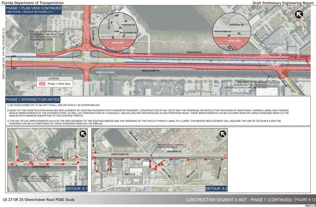
139
140
141

142

143
144

145
146

147
148
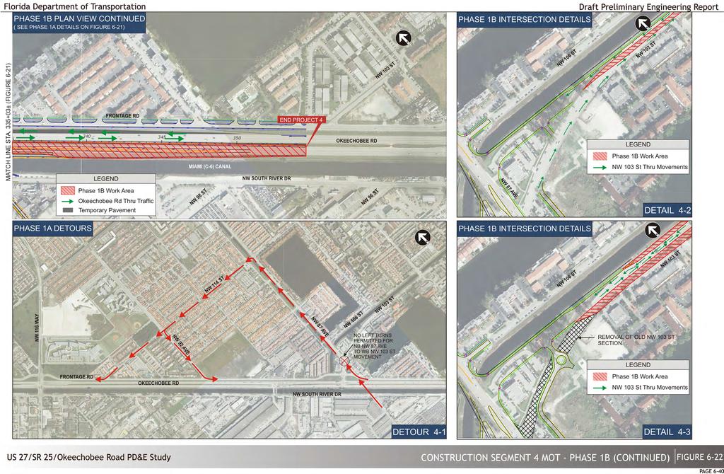
149
150

151

152
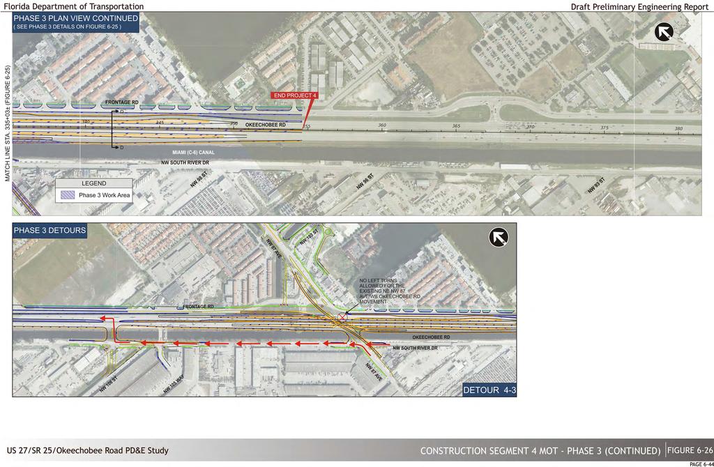
153

154
155
156
157 6.10 Environmental Impacts Aesthetics For the proposed bridges, Aesthetic Level One is anticipated for the low level bridges crossing the Miami Canal. Aesthetic Level Two is anticipated for the new flyover bridges at NW 116 th Way and NW 87 th Avenue as well as the third level Okeechobee Road mainline over NW 87 th Avenue. Although there is little room for significant landscaping improvements throughout the corridor, landscaping should be considered in some key areas during the final design (i.e. NW 116 th Way and NW 87 th Avenue) Section 4(f) Resources A Section 4(f) Determination of Applicability (DOA), a companion document to this PD&E Study, was prepared for this project and is available for review at the FDOT District Six offices in Miami. It identifies several potential Section 4(f) properties, which are described below, and provides information required by the FDOT PD&E Manual and FHWA Guidelines in the Section 4(f) DOA. It was determined by FHWA (see Appendix B) that only one pr operty, the Hialeah Gardens Bernie Wilson Park, qualifies as a Section 4(f) resource. The only Section 4(f) property that is anticipated to be impacted by the proposed improvements is the City of Hialeah Gardens Bernie Wilson Park; therefore, a N et Benefit Programmatic Section 4(f) Evaluation is currently being developed. No significant direct, indirect, or cumulative impacts are anticipated for the rest of the properties identified in the DOA. Hialeah Gardens Linear Park (Elisabeth Brotons Park) This property is located between NW 87 th Court and the NW 87 th Avenue Canal s west bank, and extends approximately 0.7 miles from NW 106 th Terrace to NW 117 th Street. Portions of this park are in public ownership and would qualify under the protections of Section 4(f), while other sections of the park are in private ownership and would not qualify as Section 4(f) properties. None of the areas of Hialeah Gardens Linear Park that qualify for protection under Section 4(f) would be us ed or impacted by the proposed project. Graham Dairy House No taking of the Graham Dairy Property or improvements directly adjacent to it are anticipated. Because the Graham Dairy House is confined to the home site, which is located within a commercial and industrial area, it is believed that there will be no adv erse effect to this property. T herefore, there will be no Section 4(f) use. Miami Canal The Miami Canal (8DA6525) has been previously determined to be National Register eligible by the SHPO. The history, existing condition, and impacts to this resource are summarized here and described in detail in the CRAS that was prepared as part of this PD&E study. As one of the six primary canals of the Everglades Drainage District, the Miami Canal is a significant example of an early water management system. It is eligible for listing in the National Register under Criterion C in the category of Engineering. The canal is also eligible for listing in the National Register under Criterion A in the category of Community Planning and Development for its role in the development of South Florida. Because of the nature of this project and the number of crossings which already exist over the Miami Canal, it is believed that there will be no adverse effect to this resource. Therefore, there will be no Section 4(f) use of the Miami Canal. CERP North Lake Belt Storage Area, Central Lake Belt Storage Area, Lake Belt In-Ground Reservoir Technology Pilot, Broward County Water Preserve Areas These areas are designated for water management and conservation purposes in the Comprehensive Everglades Restoration Project (CERP) and are located adjacent to the western portion of the project corridor, west of the Florida Turnpike. C oordination with the officials with jurisdiction occurred through phone conversations with Ms. Nirmala Jeyakumar and Mr. Jorge Jaramillo from the SFWMD in April These areas represent pre-planning conceptual locations of future water reservoir sites as submitted to the United State Congress in A search conducted using the Miami-Dade property appraiser website determined that all parcels of the Central Belt Storage Area adjacent to the south side of the Okeechobee Road Corridor are owned by the rock mining company Rinker Material Corp., with the exception of Folio No , a small triangular parcel just north of NW 118th Avenue which is owned by the Central and Southern Florida Flood Control District. On the north side of Okeechobee Road, the only publicly owned parcels along the corridor are Folio Nos and within Recommended Alternative Draft Preliminary Engineering Report 6-48
158 the North Lake Belt Storage Area and just south of NW 154th Street, as well as Folio Nos and which are part of the Lake Belt In-Ground Reservoir Technology Pilot. These publicly owned parcels will not be di rectly impacted by any of the alternatives under consideration. According to Mr. Jaramillo, the exact locations of future reservoirs within these CERP areas are still under evaluation. A lthough the main purpose and goal as stated in their Project Management Plans (PMP) is the restoration and preservation of the natural hydrology of southern Florida and the Everglades, CERP requires a r ecreational component which may include public access and recreational facilities. According to Mr. Jaramillo, such component has yet to be determined due to the preliminary phase of the project. No designated parking areas, signage or access is currently provided to the general public for their recreational use. No plans exist at the current time for the recreational use of these areas, the majority of which is still privately owned. Furthermore, FHWA determined that no direct impacts are expected to publicly owned parcels within these CERP areas. Therefore, it is assumed that these sites do not meet the requirements to be considered Section 4(f) properties. project and avoids impacts to Bernie Wilson Park. The six (6) avoidance alternatives were evaluated in terms of how they address the operational deficiencies and safety concerns as well as their impacts to the environment and the community. The results of the evaluation of the avoidance alternative indicated that a feasible and prudent avoidance alternative does not exist. There are unique problems or unusual factors involved in the utilization of alternatives that avoid Bernie Wilson Park and the traffic operational, social, economic, or environmental impacts, as well as community disruption resulting from such alternatives reach extraordinary magnitudes. Thus Alternative 7C Modified was further evaluated to determine the best option to minimize harm which may entail both alternative design modifications that reduce the amount of the Section 4(f) property used and mitigation measures that compensate for residual impacts. Although the design modifications do continue to address the needs of the project, they are inferior options (undesirable geometric alignment and t ypical section), and they do not minimize harm enough since they continue to impact the majority of the park as well as its main functions. Hialeah Gardens Bernie Wilson Park Alternative 7C Modified directly converts approximately 0.35 hectares (0.87 acres) or 71 percent of Bernie Wilson Park for transportation development by incorporation into the proposed realigned NW 103 rd Street, including the areas with playground equipment, picnic tables, and shelter. Thus, a Section 4(f) evaluation was performed in an attempt to develop an alternative that addresses the needs of the project while avoiding or minimizing impacts to Bernie Wilson Park to the greatest extent possible. An avoidance alternative is any alternative that would not require the use of any Section 4(f) property. A feasible and prudent avoidance alternative does not cause other severe problems of such a magnitude that substantially outweigh the importance of protecting Section 4(f) properties. Although Alternatives 7A and 7B were previously eliminated in the alternatives evaluation, they were re-evaluated with more stringent criteria as Avoidance Alternative 2, due to the fact that they avoid impacts to Bernie Wilson Park. In addition to the No Build (Avoidance Alternative 1) and Alternatives 7A and 7B (Avoidance Alternative 2) four (4) additional avoidance alternatives were developed and evaluated in order to determine the best alternative that both addresses the purpose and need of the This project included planning and analysis to minimize impacts to Bernie Wilson Park resulting from transportation use; however, it is not possible to impact only part of Bernie Wilson Park and leave sufficient park land to maintain its recreational functions. Due to the constraints imposed by existing development and lack of alternatives that meet the project purpose and need, as well as coordination with the owner of the resource (the City of Hialeah Gardens), FDOT preliminarily concludes that there are no feasible and prudent alternative to avoid the use of land from Bernie Wilson Park for transportation development and the proposed action includes all possible planning to minimize harm from such use. Based on on-going discussions with the City of Hialeah Gardens, two opportunities for creating a new park space in close proximity to the existing park have been identified (M1 & M2) for the mitigation of impacts to Bernie Wilson Park. It should be noted that a third site, referred to as the Machado property (owned by Machado Family LTD Partnership), was also considered but eventually rejected as a potential mitigation site. The Machado property is approximately 2.95 acres and is currently undeveloped. It is located south of NW 103 rd Street and immediately east of the fire station and Hialeah Gardens City Hall. This site was considered for mitigation but was ultimately Recommended Alternative Draft Preliminary Engineering Report 6-49

159 rejected because the owners of the property are not willing sellers and pr oceeding with condemnation could result in a potential lengthy legal battle with an uncertain outcome at this time. If the outlook for the purchase of the Machado property changes in the future, the site can be further considered as a potential mitigation site. Converting the M1 property into a park that housed the recreational facilities currently at Bernie Wilson Park could effectively compensate for the loss of Bernie Wilson Park. This mitigation strategy is contingent upon review by FHWA. Figure 6-30 Potential Mitigation Site (M1) Potential Mitigation Site M1 A potential mitigation site, hereby referred to a M1, located west of NW 87th Avenue and the proposed southbound to eastbound flyover and east of the C7 Canal connector (Figure 6-30). This site is currently owned by the State. The property currently houses a Shell gas and service station, Havana Grill Restaurant, and Marketplace Express which will be al lowed to remain onsite via a lease with the State until such time that the land is required for either a transportation or mitigation use. This site can also be supplemented by a portion of Frontage Road that will be abandoned in the proposed condition. This additional area (hatched in blue in Figure 6-30) is approximately 0.4 acres. The 0.76 hectares (1.88 acres) M1 site, could also accommodate relocation of the playground equipment, covered area, picnic tables, walking trail, and monuments from Bernie Wilson Park. This site has several additional attributes which would potentially enhance the quality and functions of this facility as a new park site, as follows: The M1 site could accommodate additional facilities including the nearby Brothers to the Rescue City monument (currently planned for relocation), which when relocated to this site would allow for improved pedestrian access compared to its existing location. The M1 site is larger than the existing park and can accommodate at amenities of equal or greater value than the existing park currently provides. The M1 site would look to enhance current park facilities such as sidewalks, benches, trees, and lights. The M1 site is off set from the main state arterial (NW 103 rd Street) which provides a safer condition for the park users. The M1 site is within walking distance of the current Park and directly adjacent to City Hall. Potential Mitigation Site M2 A second potential mitigation site, hereby referred to as M2, is located west of NW 102 nd Avenue and south of NW 138 th Street (Figure 6-31). This privately owned 9.73 acre vacant parcel is situated 2.5 miles northwest of Bernie Wilson Park and lies within an existing residential community within the City of Hialeah Gardens. This site provides for safe and direct access to City residents. The vacant parcel s location within a zoned residential area versus the commercial land use surrounding Bernie Wilson Park makes this a much more desirable location for the relocation of the Park. Recommended Alternative Draft Preliminary Engineering Report 6-50

160 Mitigation site M2 is much larger in size than the Bernie Wilson site, 9.73 acres versus 1.23 acres. Preliminary State performed appraisals place a similar monetary value on both the Bernie Wilson parcel and the M2 site because of the differences in zoning. Figure 6-31 Potential Mitigation Site (M2) The M2 site is located within a residential community and will provide safe and direct access to large numbers of City residents. The M2 site is off set from heavily traveled principal arterials which provides a safer condition for the park users. The M2 site could accommodate additional facilities including the nearby Brothers to the Rescue City monument (currently planned for relocation), which when relocated to this site would allow for improved pedestrian access compared to its existing location. The M2 site would look to enhance current park facilities such as sidewalks, benches, trees, and lights. Due to its size and location the M2 site has the potential to develop overtime into a significant community resource as additional local funds become available to fully develop the 9.73 acre park site. Because of these enhancements in recreational functions, the City of Hialeah Gardens expressed that a new park facility at the M2 site would not only replace but improve the existing Bernie Wilson Park, and would result in a Net Benefit. Converting the M2 property into a park that housed the recreational facilities currently at Bernie Wilson Park could effectively compensate for the loss of Bernie Wilson Park. This mitigation strategy is contingent upon review by FHWA. The M2 site has several additional attributes, as identified by the City, which would enhance the quality and functions of this facility as a new park site and result in a direct Net Beneficial Use of Bernie Wilson Park. Those attributes include: The M2 site is approximately eight times the size of the existing park and c an easily accommodate amenities of equal or greater value than the existing park currently provides. This is the preferred mitigation site of the Official with Jurisdiction, the Mayor and the City Commission. As detailed in the attached meeting minutes from the February 12, 2014, August 14, 2014, April 1, 2015, May 28, 2015 and September 23, 2015 meetings, the Mayor of Hialeah Gardens, the City s Director of Public Works and Director of Planning and Zoning all stated that the new realigned NW 103 rd Street with the relocated Bernie Wilson Park behind City Hall would be supported by the City of Hialeah Gardens. Furthermore, the City of Hialeah Gardens City Council signed a City Resolution on December 1 st, 2015 supporting the proposed action as well as the proposed mitigation strategy. Development of a Memorandum of Agreement (MOA) between the Florida Department of Transportation and the City of Hialeah for the Relocation of Bernie Wilson Park is currently being drafted, a copy of the draft MOA has been included in Appendix I7. Recommended Alternative Draft Preliminary Engineering Report 6-51